

- Ocean morphology is the study of the shape and relief of the ocean basins: the size, form and arrangement of the features that make up the sea floor. Areas of the floor that share a common relief and origin are grouped as marine (physiographic) provinces.
- The ocean floor is not the flat, featureless plain early navigators imagined. It carries the longest mountain chain (the mid-ocean ridge system), the deepest depressions (trenches) and the flattest plains (abyssal plains) on the planet.
- Its relief is built by the same forces that shape the continents, tectonic, volcanic and depositional, but with one key difference: there is almost no subaerial weathering. Volcanic and faulted forms therefore keep their sharp original shapes.
- The sea floor is also young. Oceanic crust is created at ridges and destroyed at trenches, so almost none of it is older than about 180 million years, while continental rocks reach 4 billion years.
Studying the Ocean Floor

Bathymetry: measuring ocean depth
- Bathymetry (Greek bathos, depth + metron, measure) is the measurement of ocean depths and the mapping of submarine relief. It is the marine counterpart of hypsometry, which measures land heights.
- Hypsometry records positive relief above sea level; bathymetry records negative relief below it.
- Line (wire) sounding was the only method for centuries. A weighted hemp line, and later piano wire, was lowered until it touched bottom.
- It was slow, since one deep sounding took hours, and inaccurate, because currents bowed the line. Its one advantage was that it could bring up a bottom sample.
- Matthew Fontaine Maury used such soundings to publish the first bathymetric chart of the North Atlantic (1854), which helped route the trans-Atlantic telegraph cable (1858).
- The Challenger Expedition (1872–76), led scientifically by Charles Wyville Thomson, made the first systematic deep soundings of the Atlantic, Pacific and Indian Oceans.
- Echo sounding times a sound pulse to the bottom and back: depth = ½ × speed of sound in seawater (about 1,500 m/s) × travel time.
- The German Meteor Expedition (1925–27) made the first systematic echo-sounding survey of an ocean, running repeated profiles across the South Atlantic. It revealed the rugged, continuous form of the Mid-Atlantic Ridge.
- Precision depth recorders (1950s) gave continuous profiles from moving ships.
- Modern methods map swaths and whole basins rather than single lines:
- Multibeam echo sounders map a strip several kilometres wide beneath the ship.
- Side-scan sonar (for example the long-range GLORIA system) images the texture of the floor.
- Satellite altimetry measures tiny bulges and dips in the sea surface produced by the gravity of seamounts and trenches, and so maps the whole ocean floor at coarse resolution.
- Seismic reflection and deep-sea drilling (the Glomar Challenger from 1968, and its successors) reveal the sediments and crust below the floor.
- Mapping is still incomplete. The international Seabed 2030 project reported in April 2026 that only about 28.7% of the world’s sea floor has been mapped by direct measurement. The rest is known only from satellite-derived estimates.
- Marie Tharp and Bruce Heezen drew the first physiographic diagrams of the ocean floors (1950s–1977). Their maps made the global ridge and rift system visible, and so prepared the ground for sea-floor spreading.
| Method | Principle | Strength | Limitation |
|---|---|---|---|
| Line sounding | Weighted line lowered to the bottom | Brings up a bottom sample | Slow; one point at a time; inaccurate in deep water |
| Single-beam echo sounding | Time of a sound echo | Continuous profile from a moving ship | Only a line beneath the ship |
| Multibeam and side-scan sonar | Fan of sound beams | Swath maps of relief and texture | Ship-based, costly, slow to cover the ocean |
| Satellite altimetry | Sea-surface height reflects gravity of the floor | Whole-ocean coverage | Coarse; small features missed |
The hypsographic curve
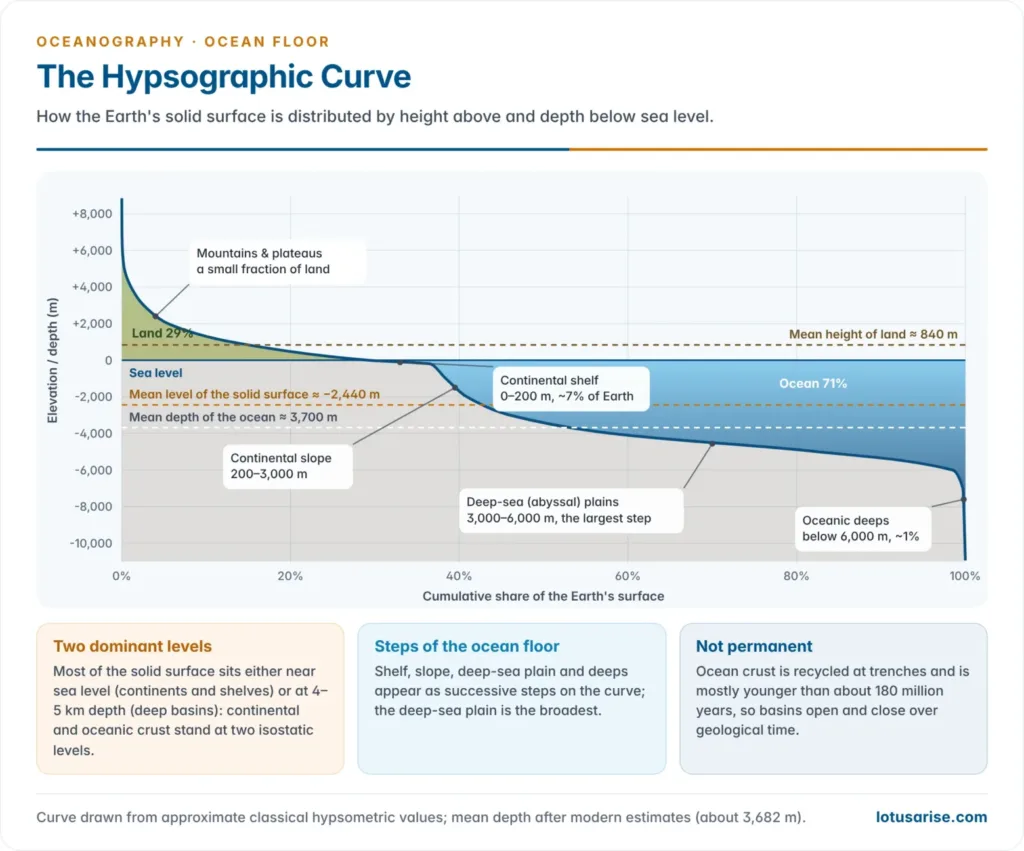
- The hypsographic (hypsometric) curve plots the cumulative percentage of the Earth’s surface against elevation above and depth below sea level.
- About 29% of the surface is land and 71% is ocean.
- The mean height of land is about 840 m. The mean depth of the ocean is about 3,700 m (a 2010 recalculation gives 3,682 m).
- The mean level of the solid surface, if all relief were levelled, lies about 2,440 m below sea level.
- On the ocean side the curve shows four steps: the continental shelf, the continental slope, the deep-sea plain and the oceanic deeps. The deep-sea plain, at about 3–6 km, is by far the broadest step.
- The curve has two dominant levels, one near sea level and one at 4–5 km depth.
- This reflects two kinds of crust floating at different isostatic levels: thick, light continental (granitic) crust and thin, dense oceanic (basaltic) crust.
- Are these units permanent? The older idea of the permanence of continents and ocean basins has been abandoned.
- Oceanic crust is continually created and consumed, so ocean basins open, widen and close over Wilson cycles of a few hundred million years. The Atlantic is opening while the Pacific is shrinking.
- Continental margins are not fixed either. Sea-level change floods or exposes the shelves, which were dry land at the last glacial maximum.
Marine provinces: classifications
- The classical four-fold division, read off the hypsographic curve, is: continental shelf, continental slope, deep-sea plain and oceanic deeps.
- A modern three-fold, process-based division is now common:
- continental margins (shelf, slope and rise);
- deep-ocean basins (abyssal plains, abyssal hills, seamounts, guyots and trenches);
- mid-ocean ridges.
- Combining the two gives the scheme used here, which treats submarine canyons, the continental rise, ridges and trenches as distinct elements.
| Scheme | Units | Basis | Weakness |
|---|---|---|---|
| Classical (four-fold) | Shelf, slope, deep-sea plain, deeps | Depth zones of the hypsographic curve | Ignores ridges and the rise |
| Modern (three-fold) | Continental margin, deep-ocean basin, mid-ocean ridge | Crust type and plate setting | Lumps very different forms together |
| Combined (used here) | Shelf, slope, canyons, rise, abyssal floor, seamounts and guyots, trenches, ridges | Form and origin | Longer, but complete |
The Continental Margin
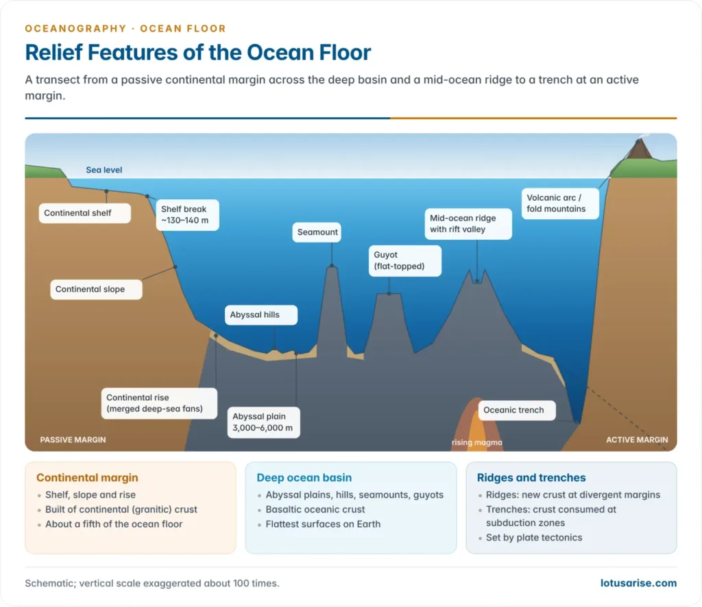
- The continental margin is the submerged edge of a continent: shelf, slope and rise.
- Geologically it is still continent, built of continental crust and a wedge of land-derived sediment, even though it lies under the sea.
- Taken together, the margins cover roughly a fifth of the ocean floor.
- There are two types of margin, depending on their plate setting:
| Feature | Passive (Atlantic-type) margin | Active (Pacific-type) margin |
|---|---|---|
| Plate setting | Inside a plate; an old rifted edge | At a convergent or transform plate boundary |
| Shelf | Wide | Narrow or absent |
| Slope and rise | Gentle slope; broad rise of coalesced fans | Steep slope; little or no rise |
| Next to the deep floor | Abyssal plain | Oceanic trench |
| Activity | Quiet: few earthquakes, no volcanoes | Earthquakes, volcanoes, young fold mountains |
| Examples | East coasts of the Americas; India’s east and west coasts | West coast of South America; Japan; Sumatra–Java |
Continental shelf
- The continental shelf is the gently sloping, shallow submerged platform that fringes a continent. It runs from the shore out to the shelf break, where the gradient steepens sharply.
- Gradient: very gentle, on average about 0.1° (roughly 2 m per km) and rarely more than 1°.
- Depth at the break: averages about 130–140 m. It is traditionally taken as the 100-fathom (about 180–200 m) line, and reaches about 350 m around Antarctica, where the weight of the ice sheet has pushed the crust down.
- Width: averages about 70–80 km, but ranges from almost nothing to more than 1,200 km. The broadest shelves are off northern Siberia in the Arctic, the Sunda Shelf of South-East Asia, and the Yellow and East China Seas.
- Area: about 7–8% of the ocean floor. It is proportionately largest in the Atlantic, with its many marginal seas, and smallest in the Indian Ocean.
- Width is controlled by the coast behind it:
- Narrow where young fold mountains run along the coast. The shelf off Chile and Peru is often under 20 km wide because the Andes rise straight from the sea at an active margin.
- Wide off broad lowlands, large deltas and glaciated coasts, as on the Atlantic coast of North America and in the North Sea.
- The shelves were dry land during glacial periods.
- At the last glacial maximum (about 20,000 years ago) sea level stood about 120–130 m lower. Most shelves were exposed, crossed by rivers and grazed by animals; mammoth teeth are still dredged from the North Sea.
- Drowned river valleys, relict beaches and terraces survive on many shelves.
- The shelf has great economic and strategic value:
- Sunlight reaches the bottom and nutrients arrive from land, so shelves yield most of the world’s fish catch. Examples are the Grand Banks, Dogger Bank (North Sea) and Sunda Shelf.
- Their thick sediments hold a large share of offshore oil and gas (Mumbai High, about 160 km off Mumbai; North Sea; Gulf of Mexico) and placer deposits such as tin off Malaysia and Indonesia, and ilmenite and monazite sands along the Kerala coast and inner shelf.
- They give coastal states sovereign rights over the legal continental shelf under UNCLOS.
- A broad, shallow shelf slows and heightens tides and storm surges. This is why the head of the Bay of Bengal suffers some of the world’s highest cyclone surges.
Origin of continental shelves
- No single process explains all shelves. Most are polygenetic:
| View | Process | Typical example |
|---|---|---|
| Drowning (submergence) | Rise of sea level or sinking of the continental edge floods the coastal plain | Most shelves after the post-glacial sea-level rise |
| Constructional (depositional) | Rivers build a wedge of sediment that grows seaward while the margin slowly subsides under its load | Off the Amazon and Ganga–Brahmaputra |
| Wave-cut and wave-built | Waves cut a platform; the eroded debris builds a terrace at its outer edge | Narrow shelves round Iceland and the Faroes |
| Glacial control (Reginald Aldworth Daly) | Pleistocene sea-level fall exposed margins to glacial and wave erosion; the platforms were drowned when the ice melted | Glaciated shelf off Norway, with deep troughs and moraines |
| Faulting | Coast-parallel faults let the margin subside | Red Sea; west coast of India |
| Delta growth | A fast-growing delta extends a local shelf | Mississippi delta |
| Coral-built | Reef growth forms a platform with a very steep outer slope | Lakshadweep, Gulf of Mannar, Great Barrier Reef |
- The modern explanation comes from plate tectonics. A passive-margin shelf is the top of a thick sediment wedge resting on stretched continental crust.
- The crust was thinned when the continents rifted apart. It has subsided as it cooled, and the wedge has kept pace through sedimentation.
- Quaternary sea-level swings have repeatedly planed and drowned its surface.
Continental shelf of India
- The west coast shelf is far wider than the east coast shelf.
- The west coast shelf is widest off Gujarat and Maharashtra, where it forms the Bombay offshore basin.
- The east coast shelf is narrow, especially off the deltas of the Ganga, Mahanadi, Godavari, Krishna and Kaveri, where sediment builds outward and the slope plunges quickly.
- Different processes shaped different stretches:
- faulting and subsidence along the west coast, part of the rifted margin left when India broke from Madagascar and the Seychelles;
- deltaic growth off the east-coast rivers;
- sedimentation with subsidence along the Coromandel coast;
- coral growth around Lakshadweep, the Andaman–Nicobar Islands and the Gulf of Mannar.
Continental slope
- The continental slope descends from the shelf break (about 130–200 m) to about 2,000–3,000 m. It is the true edge of the continent, where continental crust gives way to oceanic crust.
- Gradient: averages about 4° and ranges from 1° to over 25°. It is steepest off volcanic islands and active margins, where it averages above 5° around the Pacific, and gentlest off large deltas.
- Area: about 8.5% of the ocean floor.
- Relief: the slope is cut by submarine canyons and scarred by slumps and slides.
- Sediments are thin for three reasons: material slides or is carried down to the rise, the slope lies far from land-derived supply, and turbidity currents sweep it clean.
- With little light, plant life is scarce and benthic life is sparse.
- The slope has more than one origin:
- Fault scarps, mainly on active and rifted margins.
- The prograding front of the sediment wedge, mainly on passive margins.
- Down-warping (flexure) of the continental edge.
- Reef talus below coral platforms.
Submarine canyons
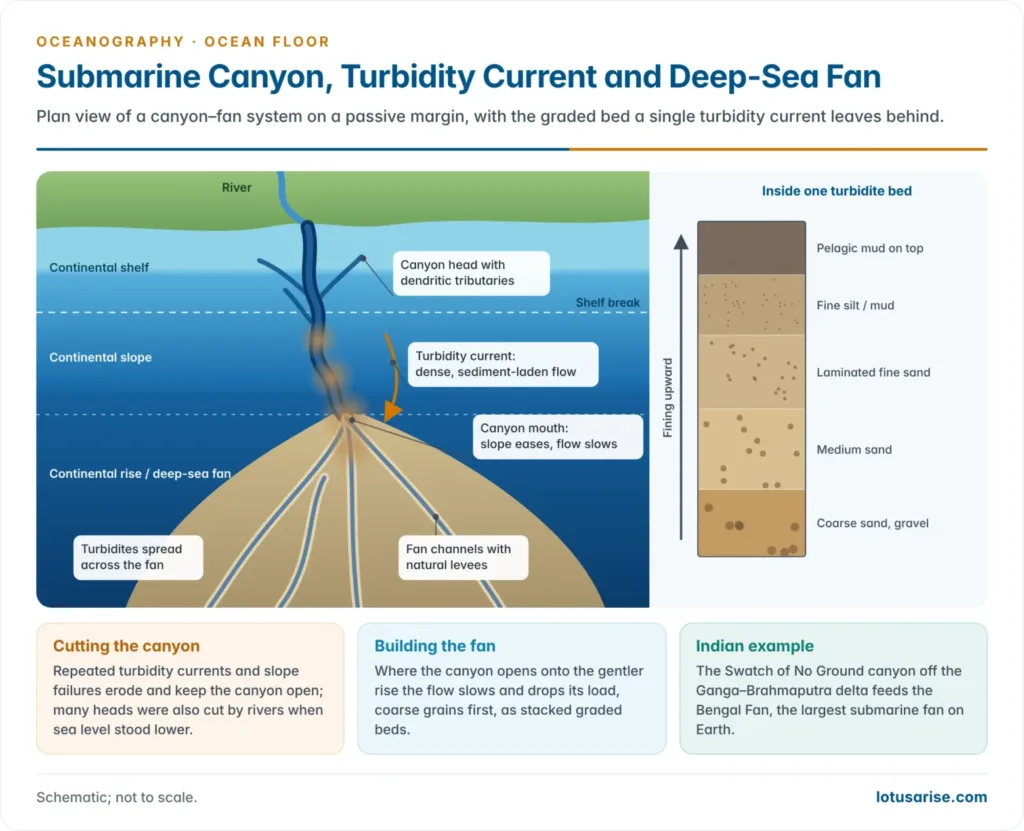
- Submarine canyons are long, narrow, steep-walled, V-shaped valleys cut into the continental shelf and slope. They often run on to the rise and the deep-sea fans.
- Many are comparable in size to the Grand Canyon of the Colorado. Monterey Canyon off California is the classic example.
- Most run at right angles to the coast and many lie opposite large river mouths, such as the Hudson, Congo and Indus. Others have no river connection.
- Some are winding. Many have dendritic tributaries at their heads, like land valleys.
- Their walls expose rocks of many ages, from soft shales to granite. Their floors carry coarser sediment (sand, gravel, pebbles) than the shelf on either side, which shows that strong currents pass through them.
- Size and form:
- Average length is a few tens of kilometres. Large canyons extend for hundreds, and the Congo Canyon continues seaward as a fan valley for hundreds of kilometres.
- Wall height is commonly a few hundred metres to over 1,000 m.
- Longitudinal gradient is steeper than that of land canyons. It averages a few per cent and is steepest off islands.
- Distribution:
- No latitudinal control. Canyons are common along straight coasts of both stable and active margins.
- Major areas are the US Atlantic coast from Cape Cod to Cape Hatteras, California and Mexico, Japan and the Aleutians, the northern Mediterranean, the Bay of Biscay and Portugal (Nazaré Canyon, one of Europe’s deepest), and West Africa.
- Hudson Canyon was the first to be described, in 1885.
- Indian examples:
- The Swatch of No Ground is a canyon cutting diagonally across the shelf south of the Ganga–Brahmaputra delta. Its flat floor is about 5–7 km wide and about 1,200 m deep at the shelf edge. It is a channel that feeds sediment to the Bengal Fan, and a known cetacean habitat.
- Smaller east-coast canyons lie off the Mahanadi (Paradip), Godavari, Krishna, Penneru, Palar, Puducherry and Cuddalore coasts.
- The Indus Canyon lies off the Indus delta on the western margin.
Theories of origin of submarine canyons
- Glacial canyons are broad troughs cut by ice on high-latitude shelves, as off Norway and in the Arctic. They are easy to explain. The debate concerns the far more numerous non-glacial canyons:
| Theory | Main proponents | Mechanism | Criticism |
|---|---|---|---|
| Subaerial erosion (drowned river valleys) | James Dwight Dana; Francis Parker Shepard (early view) | Rivers cut valleys across the exposed shelf and slope when sea level was low; the valleys were later drowned | Pleistocene sea level fell only about 120–130 m, which cannot explain canyons cut to 2,000 m and more. Shepard later accepted that several processes are involved |
| Diastrophic (tectonic) | De Andrade, Andrew Cowper Lawson, John Walter Gregory, Jacques Bourcart | Faulting, warping and graben formation along the margin | Faults usually run parallel to the coast, canyons across it; dendritic tributaries are not tectonic; many canyons lie on quiet Atlantic margins |
| Density currents | François-Alphonse Forel (for lake trenches) | Dense river water flowing along the floor erodes a channel and builds levees | Such currents are weak and are mostly confined to lakes and enclosed seas |
| Turbidity currents | Reginald Aldworth Daly (1936); later Philip Henry Kuenen, Bruce Heezen and Maurice Ewing | Dense, sediment-laden flows rush down the slope, erode the floor and keep canyons open | Early doubts that they could cut hard rock; now regarded as the main agent of canyon cutting below the shelf |
| Slumps and mudflows | Shepard and Kenneth Orris Emery | Slope failures and mudflows deepen and widen canyons | Deepen existing canyons rather than create them |
| Spring sapping | Douglas Wilson Johnson (1939) | Groundwater emerging on the slope dissolves and undermines rock | Too slow and too local to explain canyons worldwide |
| Tsunami currents | — | Powerful backwash of tsunamis scours the slope | Tsunamis are mostly a Pacific phenomenon, while canyons are found worldwide |
- The 1929 Grand Banks earthquake proved the turbidity-current idea. A slope failure off Newfoundland broke trans-Atlantic telegraph cables in sequence, farther and farther downslope over about 13 hours.
- From the timing of the breaks, Bruce Heezen and Maurice Ewing (1952) showed that a turbidity current had raced down the slope at tens of kilometres per hour, spreading a graded sand layer over the abyssal plain.
- Present-day monitoring confirms it. A 2015–17 instrumented study of Monterey Canyon recorded 15 flows.
- Most began near the canyon head in under about 300 m of water. The three largest ran more than 50 km down the canyon.
- The study found that the upper metres of the canyon floor itself move as a dense, fluid sediment layer. The dilute sediment cloud above is only a secondary effect.
- The accepted view is polygenetic, close to the position of Philip Henry Kuenen:
- Many canyon heads began as river valleys cut at low sea levels.
- Turbidity currents, slumps and other mass flows have deepened and extended them down the slope.
- Tectonics decides where canyons form on active margins.
Continental rise and deep-sea fans
- Deep-sea (submarine) fans are fan- or cone-shaped piles of sediment at the mouths of submarine canyons, at the foot of the slope. They are the marine counterpart of alluvial fans.
- They are built by turbidity currents, which slow and spread out where the canyon opens onto the gentler floor.
- Each flow leaves a turbidite, a bed that fines upward from coarse sand at the base to silt and mud at the top (graded bedding).
- The fan surface is crossed by channels flanked by natural levees that branch like distributaries, and by abandoned channels.
- Coalescing fans form the continental rise:
- a gentle apron with a gradient of about 1:100 to 1:800, between about 1,500 and 5,000 m deep, up to several hundred kilometres wide, merging seaward into the abyssal plain;
- well developed in the Atlantic and Indian Oceans;
- rare in the Pacific, where trenches at the foot of the slope trap the sediment before it can spread.
- The Indian Ocean has the world’s two largest fans:
- The Bengal Fan is the largest submarine fan on Earth, about 3,000 km long and 1,400 km wide, with sediment up to about 16.5 km thick. It is built of Himalayan sediment delivered by the Ganga–Brahmaputra through the Swatch of No Ground.
- The Indus Fan in the Arabian Sea is the second largest.
- Both are a record of Himalayan uplift and monsoon erosion over tens of millions of years.
The Deep Ocean Floor
Abyssal plains
- Abyssal (deep-sea) plains are very flat, sediment-covered surfaces at about 3,000–6,000 m. They are the flattest surfaces on Earth, with slopes gentler than 1:1,000, flatter than any land plain.
- How they form:
- Turbidity currents and slow pelagic settling blanket the rough basaltic crust and bury the abyssal hills beneath hundreds of metres of sediment.
- Turbidites spread from the rise. Far from land, the floor carries pelagic oozes made of plankton shells, and red clay, which is fine wind-blown and volcanic dust in the deepest basins.
- Their extent differs between the oceans:
- Extensive in the Atlantic and Indian Oceans. Their passive margins let land sediment reach the deep floor; the Bengal and Indus fans feed the Indian Ocean plains.
- Limited in the Pacific. Trenches round its rim trap the sediment, so the Pacific floor is dominated by abyssal hills.
- Even the “plains” carry relief. Continuous echo sounding shows hills, seamounts, fracture zones and channels rising sharply from them.
Abyssal hills, seamounts and guyots
- Abyssal hills are the most widespread landform on Earth, covering much of the deep floor on the ridge flanks.
- They are low hills, usually under 1,000 m high and a few kilometres across, arranged in lines parallel to the ridge.
- Most are fault blocks and small volcanoes formed as new crust is stretched at the ridge axis. They are best exposed in the Pacific, where little sediment buries them; such areas are called abyssal hill provinces.
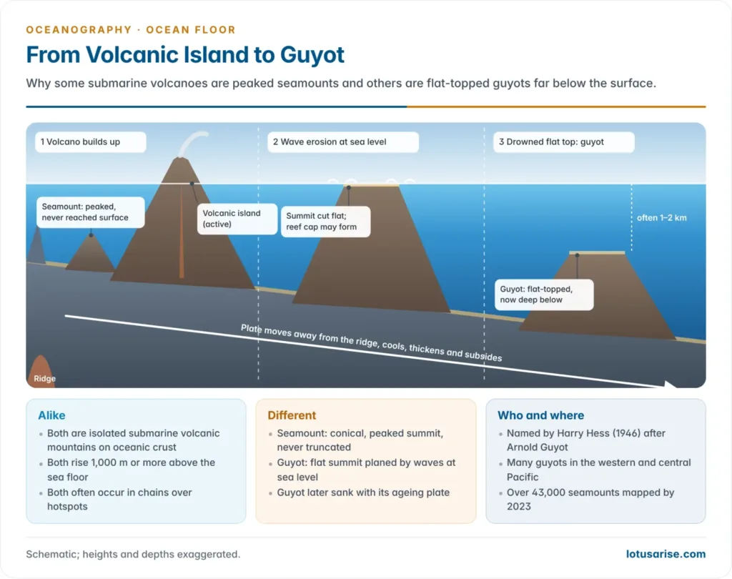
- Seamounts are isolated submarine volcanoes, conventionally more than 1,000 m high, with peaked, conical summits that stay below sea level. Smaller ones are called knolls.
- They occur singly or in chains over hotspots. The Hawaiian–Emperor chain records the Pacific Plate moving over the Hawaiian hotspot.
- Satellite gravity mapping in 2023 added about 19,300 new seamounts, bringing the catalogue to about 43,000. Many thousands more are thought to remain undetected.
- Seamounts are biological hotspots, because currents deflected up their flanks bring nutrients up. They are also targets for cobalt-rich ferromanganese crusts.
- Guyots (tablemounts) are flat-topped seamounts. The term was coined by Harry Hammond Hess (1946), after the geographer Arnold Henry Guyot.
- Their origin, as Hess explained it:
- The volcano grows into an island near a ridge or over a hotspot.
- Once extinct, its summit is planed flat by waves at sea level, and a coral reef may cap it.
- The plate carries it away and cools and subsides, so the flat top sinks, often 1–2 km below the surface.
- Dredged shallow-water fossils, rounded cobbles and reef limestone from guyot tops confirm that the summits were once at sea level.
- Guyots are most numerous in the western and central Pacific, between Hawaii and the Marianas.
- Their origin, as Hess explained it:
| Feature | Seamount | Guyot |
|---|---|---|
| Origin | Submarine volcano | Submarine volcano that once reached sea level |
| Summit | Peaked, conical | Flat, wave-planed, sometimes reef-capped |
| Depth of summit | Never reached the surface | Commonly 1–2 km below sea level after subsidence |
| Evidence | Volcanic rock | Shallow-water fossils, beach cobbles, reef limestone |
| Link to coral atolls | — | A drowned atoll is one route to a guyot when subsidence outpaces reef growth |
- The link to atolls is the same subsidence that Charles Darwin invoked for coral reefs and atolls. A guyot is in effect a reef platform that sank too fast for coral growth to keep pace.
Oceanic trenches and deeps
- Trenches are long, narrow, steep-sided, arc-shaped depressions, the deepest parts of the ocean, commonly 6,000–11,000 m deep.
- Troughs are broader, gentler-sided depressions. Deeps are the deepest spots within a trench.
- Form: trenches are asymmetric. The landward (arc-side) wall is steeper than the seaward wall. They run parallel to young fold mountains or to the convex side of island arcs.
- Origin: trenches mark subduction zones, where oceanic lithosphere bends down beneath another plate.
- This explains their belts of deep earthquakes (the Wadati–Benioff zone), the volcanic arcs beside them, and their concentration round the Pacific Ring of Fire.
- They are rare in mid-ocean. In the Atlantic they occur only at the Puerto Rico and South Sandwich arcs, and in the Indian Ocean mainly at the Java (Sunda) Trench off Sumatra and Java.
- The deepest point on Earth is the Challenger Deep in the Mariana Trench. A 2021 NOAA analysis put it at about 10,935 m, so Mount Everest would sink with about 2 km of water to spare.
- It was first reached in 1960 by Jacques Piccard and Don Walsh in the bathyscaphe Trieste.
- India’s Deep Ocean Mission is building the crewed submersible Matsya-6000, designed for 6,000 m.
| Ocean | Deepest point | Approximate depth (m) |
|---|---|---|
| Pacific | Challenger Deep, Mariana Trench | 10,935 |
| Atlantic | Puerto Rico Trench | 8,376 |
| Southern | South Sandwich Trench (southern end) | 7,434 |
| Indian | Java (Sunda) Trench | 7,192 |
| Arctic | Molloy Deep, Fram Strait | 5,550 |
- Other very deep trenches are all in the Pacific: the Tonga (about 10,800 m), Philippine (about 10,500 m), Kuril–Kamchatka and Kermadec trenches.
Mid-ocean ridges
- The mid-ocean ridge system is the longest mountain range on Earth, about 65,000 km long. It winds through every ocean like the seam of a ball and rises about 2–3 km above the abyssal floor.
- It is 1,000–4,000 km wide, broad and gentle rather than peaked, and occupies about a third of the ocean floor.
- It is not always central. The Mid-Atlantic Ridge and the Carlsberg and Central Indian Ridges lie near mid-ocean, but the East Pacific Rise lies well to the east of the Pacific’s centre.
- Where it is built up by excess volcanism it rises above sea level, as in Iceland and the Azores.
- Origin: ridges are divergent plate boundaries. As plates move apart, pressure on the hot mantle falls, it partly melts, and basaltic magma wells up to form new oceanic crust (pillow lavas on the sea floor).
- Hot, young crust stands high. It cools, thickens and subsides as it moves away. This is why ocean depth increases with crustal age and why ridges are broad swells.
- Spreading rate shapes the crest:
| Feature | Slow-spreading ridge (Mid-Atlantic Ridge) | Fast-spreading ridge (East Pacific Rise) |
|---|---|---|
| Spreading rate | About 2–5 cm/yr | Up to about 15 cm/yr |
| Crest | Deep axial rift valley 1–3 km deep, rugged flanks | Smooth, broad rise with no deep rift valley |
| Profile | Narrower, steeper | Broader, gentler |
- Transform faults offset the ridge into segments. Their inactive extensions, fracture zones such as the Romanche in the equatorial Atlantic, form long scarps and troughs at right angles to the ridge.
- Hydrothermal vents were first found in 1977 on the Galápagos Rift, by the submersible Alvin.
- Seawater seeping into the hot crust is heated and returns rich in dissolved metals.
- Black smokers vent water at about 350–400 °C, laden with metal sulphides. White smokers are cooler and rich in barium, calcium and silica.
- Vents support chemosynthetic ecosystems of tube worms, clams and bacteria, independent of sunlight.
- They build polymetallic sulphide deposits. India holds an International Seabed Authority contract (2016) to explore these on the Central and South-West Indian Ridges.
Relief features compared
| Feature | Typical depth | Gradient or form | Origin |
|---|---|---|---|
| Continental shelf | 0 to about 130–200 m | About 0.1° | Drowned continent, sediment wedge, sea-level change |
| Continental slope | 200 to about 3,000 m | About 4° | Edge of continental crust; faulting, prograding sediment |
| Submarine canyon | Cuts shelf and slope | V-shaped, steep-walled | Low-sea-level rivers plus turbidity currents and mass flows |
| Continental rise and fans | About 1,500–5,000 m | 1:100 to 1:800 | Coalescing turbidite fans |
| Abyssal plain | 3,000–6,000 m | Under 1:1,000 | Sediment burying rough oceanic crust |
| Seamount and guyot | Summit below the surface | Conical or flat-topped | Intraplate or ridge volcanism; guyots subsided after wave planation |
| Trench | 6,000–11,000 m | Narrow, asymmetric | Subduction of oceanic lithosphere |
| Mid-ocean ridge | Crest about 2,500 m | Broad swell, rift or rise | Sea-floor spreading at divergent boundaries |
Previous Year Questions
2026How are seamounts and Guyots the same and different? Comment.2010Explain the scientifically sound methods of bathymetry and give an account of the bottom topography of the Atlantic Ocean.1999Write short note: Submarine canyons.1996Explain and illustrate the ocean floor topography and give a detailed account of the Mid-Atlantic Ridge.1991Draw a hypsographic curve to represent the major physiographic units of the ocean and comment on their permanency.1989Write short note on ocean bottom relief in about 200 words.




