1. Continents And Ocean Basins: Distributional Characteristics
Before any theory of origin can be evaluated, the examiner expects you to first establish what the present-day distribution actually looks like, because every theory (Taylor, Wegener, Plate Tectonics) is ultimately judged by how well it explains this observed pattern. Continents and ocean basins are together called “relief features of the first order” — the largest-scale relief features on the planet, larger than mountains, plateaus or plains, which are “relief features of the second order.”
1.1 The Basic Area Split
- Oceans occupy 70.8% of the Earth’s total surface area; continents occupy the remaining 29.2%.
- This split is not uniform between hemispheres — it varies sharply depending on how you divide the globe.
1.2 Land Hemisphere vs Water Hemisphere
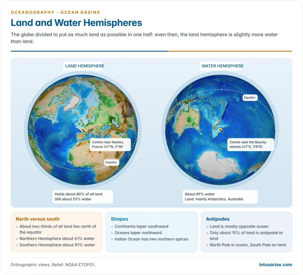
If the globe is divided into two hemispheres such that the “north pole” of this division is placed in the English Channel and the “south pole” of this division is placed near New Zealand, then:
- The hemisphere containing the English Channel pole becomes the Land Hemisphere, containing 83% of the world’s total land area.
- The opposite hemisphere (containing the New Zealand pole) becomes the Water Hemisphere, containing 90.6% of the world’s total oceanic area.
This shows that land and water are not just unevenly distributed between the geographic North and South hemispheres, but are concentrated even more sharply when hemispheres are drawn to maximise the contrast.
1.3 Hemispheric Asymmetry (Geographic N–S Split)
- More than 75% of the world’s total land area lies north of the equator, i.e., in the Northern Hemisphere.
- Correspondingly, water bodies dominate the Southern Hemisphere.
- The North Pole is surrounded entirely by oceanic water (the Arctic Ocean sits over the pole).
- The South Pole, in contrast, is surrounded by a landmass — the Antarctic continent.
This asymmetry is geologically significant because it affects heat distribution, ocean circulation patterns, and — importantly for this chapter — it becomes one of the key “facts to be explained” by any drift theory.
1.4 Triangular Shape of Continents and Oceans
A distinctive and often-tested observation is that both continents and oceans have a roughly triangular outline, but oriented oppositely:
Continents — base in the north, apex pointing south:
- North + South America together: form an equilateral triangle with base along the Arctic Sea and apex at Cape Horn. Taken separately, each also forms its own triangle.
- Eurasia: base along the Arctic Sea, apex near the East Indies.
- Africa: base towards the north, apex at the Cape of Good Hope.
- Exceptions: Australia and Antarctica do not follow this triangular, north-base/south-apex pattern.
Oceans — base in the south, apex pointing north (the reverse of continents):
- Atlantic Ocean: base extends between Cape Horn and the Cape of Good Hope; apex lies to the east of Greenland.
- Indian Ocean: base in the south, but it has two apices — one in the Bay of Bengal, one in the Arabian Sea (a distinctive bifurcated apex pattern, unlike the single-apex Atlantic/Pacific).
- Pacific Ocean: base lies in the south, apex near the Aleutian Islands.
This continent–ocean shape complementarity is one of the observational puzzles that any comprehensive theory of the earth’s surface must explain, and it is precisely this puzzle that motivated early theorists like Lowthian Green to propose alternative (now discarded) explanations such as the Tetrahedral Hypothesis.
1.5 Antipodal Arrangement
“Antipodal” refers to points diametrically opposite each other on the globe (through the Earth’s centre). The data here is counter-intuitive and worth memorising exactly:
- Only 44.6% of oceans lie antipodal (opposite) to other oceans.
- Only 1.4% of the total land area lies antipodal to other land.
- This means more than 95% of the world’s land area is antipodal to water, not to other land.
- Exceptions to this general antipodal-to-water rule (only two cases exist):
- Patagonia (southern South America) is antipodal to a part of northern China.
- New Zealand is antipodal to Portugal and Spain (the Iberian Peninsula).
1.6 The Pacific Problem
- The Pacific Ocean basin alone occupies almost one-third of the entire surface area of the globe — it is the single largest relief feature on Earth.
- The Pacific, together with its associated island arcs and festoons (curved chains of islands, e.g., Japan, Philippines, Kuriles), represents the single most difficult observational problem that any drift/origin theory must account for. This is precisely why Lowthian Green’s Tetrahedral Hypothesis was proposed (though it is now discarded along with the views of Kelvin, Sollas, and Love, since they rest on obsolete assumptions).
1.7 Why This Data Matters for Answer-Writing
Any theory of continental drift or plate tectonics that you write about should ideally be evaluated against these seven observational facts:
- (i) hemispheric land–water asymmetry,
- (ii) pole coverage asymmetry,
- (iii) triangular shape complementarity,
- (iv) antipodal arrangement,
- (v) the Pacific’s disproportionate size,
- (vi) presence of island arcs/festoons, and
- (vii) the broad north–south alignment of fold mountains.
Only Plate Tectonic Theory today is considered capable of coherently explaining all of these; the older theories (contraction theory, Taylor’s, Wegener’s, Tetrahedral Hypothesis) each explain only part of the picture, which is exactly why they were superseded.
2. Pre-Plate-Tectonic Theories Of Continental Drift
2.1 F.B. Taylor’s Continental Drift Theory (1908/1910)
Historical context and aim: F.B. Taylor’s concept of the “horizontal displacement of continents” was formulated in 1908 but published only in 1910. Unlike Wegener (whose primary concern was climate), Taylor’s motivating problem was purely structural/orogenic: he wanted to explain the peculiar distributional pattern of the Tertiary fold mountains. Specifically, two observations troubled him:
- The north–south alignment of the Rockies and Andes along the western margins of North and South America.
- The west–east alignment of the Alpine mountain systems of Eurasia (Alps, Caucasus, Himalayas).
The prevailing explanation of the time — the Contraction Theory (mountains form because the Earth is cooling and shrinking, wrinkling its crust like a drying apple) — could not satisfactorily explain this directional contrast in mountain orientation. Taylor therefore proposed his own “drift” or “displacement” theory as an alternative. Note: although Taylor is usually credited as the pioneer of continental drift thinking, Antonio Snider had actually proposed a drift idea even earlier, in 1858 in France, in order to explain the similarity between Carboniferous coal-seam fossils of North America and Europe — but Snider’s idea did not develop into a full theory the way Taylor’s and later Wegener’s did.
The theory itself:
- Taylor started his reconstruction from the Cretaceous period, at which point he assumed there were two landmasses: Lauratia (located near the North Pole) and Gondwanaland (located near the South Pole).
- The continents, in his view, were composed of sial, a material that was “practically absent” in the oceanic crust — this sial/sima distinction (borrowed and later refined by Wegener) is central to nearly all early drift theories.
- Taylor proposed continents drifted in two directions simultaneously:
- Equatorward movement — continents move from the poles towards the equator.
- Westward movement — continents also drift from east to west.
- The driving force for both types of movement, according to Taylor, was the tidal force of the Moon.
Mechanism:
- Lauratia began moving away from the North Pole because of the Moon’s enormous tidal pull acting radially towards the equator.
- This equatorward movement generated tensional stress near the North Pole, causing stretching, splitting, and rupture of the landmass — this is how Baffin Bay, the Labrador Sea, and the Davis Strait were formed.
- Similarly, Gondwanaland’s displacement from the South Pole towards the equator caused splitting, forming the Great Australian Bight and the Ross Sea around Antarctica.
- The Arctic Sea formed between Greenland and Siberia due to the equatorward movement of Lauratia.
- The Atlantic and Indian Oceans were supposedly formed by the filling of gaps that opened up between the drifting continents.
- Taylor assumed the landmasses moved in a lobe-like form while drifting through “zones of lesser resistance,” and mountains/island arcs formed at the frontal edges of these moving lobes. Thus: the Himalayas, Caucasus, and Alps formed during the equatorward movement of Lauratia and Gondwanaland (from north and south poles respectively), while the Rockies and Andes formed due to the westward movement of the landmasses.
Critical Evaluation:
- ✗ Scale problem: Taylor described displacement of landmasses over thousands of kilometres, but the actual amount of horizontal movement needed to produce fold mountains would only require 32–64 km of displacement — Taylor’s proposed scale was wildly excessive for the phenomenon he was trying to explain.
- ✗ Force problem: If the Moon’s tidal force during the Cretaceous was strong enough to displace landmasses by thousands of kilometres, it would also have been strong enough to brake the Earth’s rotation — and A. Holmes pointed out that such a force would have stopped Earth’s rotation within a single year, which obviously did not happen. Holmes concluded that neither tidal force nor any other external force can drift continents; the responsible force must originate from within the Earth (a conclusion later vindicated by mantle convection theory).
- ✓ Positive legacy: Despite these flaws, Taylor is given credit for forcefully and deductively challenging the then-dominant “permanency of continents and ocean basins” doctrine, and for directly objecting to the contraction theory — opening a new line of inquiry. As A. Holmes remarked: “Taylor must be given credit for making an independent and slightly an earlier start in this precarious field.”
2.2 Alfred Wegener’s Continental Drift Theory
Who was Wegener and what was his aim: Alfred Wegener was a German meteorologist (not a geologist) — this is an important and often-asked fact, because it explains why his central concern was climatic, not structural. He first proposed his concept in 1912, but it only became widely known after his 1922 book Die Entstehung der Kontinente und Ozeane (“The Origin of Continents and Oceans”), translated into English in 1924.
His displacement hypothesis was built by synthesising evidence from a wide range of fields — geology, palaeo-climatology, palaeontology, palaeobotany, and geophysics. The central problem Wegener wanted to solve was: why does the geological record show major climatic changes across Earth’s history (e.g., glacial deposits found in currently tropical regions)? He identified two logically possible explanations:
- Continents remain stationary; climatic zones shift — i.e., a fixed region experiences different climates over geological time because the climate belts themselves move.
- Climatic zones remain stationary; continents move (drift) — i.e., a region’s climate seems to “change” only because the land itself has physically moved into or out of that climatic zone.
Wegener rejected the first option (because it required believing continents/ocean basins are permanent, a view he found untenable) and adopted the second — displacement hypothesis. Thus, unlike Taylor (who wanted to explain mountain distribution) or the later plate tectonics theory (which is driven by geophysical evidence), Wegener’s motivating question was fundamentally about explaining past climate.
Basic premise — the three-layer Earth (borrowed from Edward Suess):
- Sial (silica + aluminium) — outer layer, forms continental crust; light, floats.
- Sima (silica + magnesium) — intermediate layer, forms oceanic crust; denser.
- Nife (nickel + iron) — inner layer/core.
Wegener believed the sialic continental masses were floating on sima without any frictional resistance — a claim that, as we shall see in the evaluation, later became one of the theory’s biggest internal contradictions.
Pangaea and Panthalasa: Using evidence from palaeoclimatology, palaeontology, palaeobotany, geology, and geophysics, Wegener proposed that all landmasses were united into a single supercontinent, Pangaea, during the Carboniferous period. Several smaller inland seas were scattered across Pangaea, and the entire supercontinent was surrounded by one vast ocean, which Wegener named Panthalasa — representing the primeval Pacific Ocean.
- Lauratia = present-day North America + Europe + Asia → formed the northern part of Pangaea.
- Gondwanaland = South America + Africa + Madagascar + Peninsular India + Australia + Antarctica → formed the southern part of Pangaea.
- The South Pole was located near present-day Durban (Natal, southern Africa) during the Carboniferous period — this specific detail is important because it later explains the pattern of Carboniferous glaciation.
Importantly, Wegener’s reconstruction begins from the Carboniferous period — he does not claim to know the exact pre-Carboniferous configuration, though he did not necessarily disbelieve in pre-Carboniferous drift; he simply held that evidence before this period was too uncertain (J.A. Steers, 1961). The Pangaea supercontinent was disrupted during subsequent geological periods, and the broken landmasses drifted apart to eventually reach their present positions.
Evidences Supporting the Theory:
- Geographical/jig-saw fit: Wegener observed that the coastlines on either side of the Atlantic Ocean show a striking geographical similarity — the eastern coast of South America and the western coast of Africa can be fitted together much like two pieces of a torn sheet of paper or two cut pieces of wood refitted together.
- Geological continuity across the Atlantic: The Caledonian and Hercynian mountain systems found on the western (American) and eastern (European) coastal areas of the Atlantic are structurally similar and identical in age/composition. Similarly, the Appalachian Mountains of north-eastern North America are geologically compatible with the mountain systems of Ireland, Wales, and north-western Europe — suggesting these mountain belts were once continuous before the Atlantic opened up and separated them.
- Du Toit’s detailed coastal study: The South African geologist Alex du Toit, after detailed study of the eastern coast of South America and western coast of Africa, confirmed that the geological structures of both coasts are broadly similar. However, he clarified that the landmasses cannot be brought together in a perfect fit — a gap of 400–800 km would remain even in the “joined” reconstruction, because this gap corresponds to the width of the continental shelves and slopes of the two landmasses (which are technically part of the continents but get “used up” in the fitting process).
- Fossil and vegetation similarity: There is marked similarity in the fossils and vegetation remains found on the eastern coast of South America and the western coast of Africa — species that could not plausibly have crossed a vast ocean naturally are found on both sides.
- Geodetic (drift-rate) evidence: Geodetic surveys reported that Greenland is drifting westward at a rate of about 20 cm per year. (Note for critical evaluation: this specific claim was later found to be based on measurement error, but the general fact of continental movement was subsequently confirmed independently through post-1960 seafloor spreading evidence.)
- Lemming migration behaviour: The lemmings (small rodents) of northern Scandinavia show a tendency to migrate westward when their population increases sharply, and they are frequently found drowned in the sea beyond the Norwegian coast because there is no land beyond it. Wegener’s supporters argued this instinctive westward migration behaviour is a biological “memory” of a time when the landmasses were physically continuous, allowing the animals to migrate to far-off places in the western direction over land.
- Glossopteris flora distribution: The fossil fern Glossopteris is found distributed across India, South Africa, Australia, Antarctica, and the Falkland Islands — regions now separated by vast oceans. This flora could not have spread across open ocean, proving these landmasses were once contiguous, unified as part of Pangaea.
- Carboniferous glaciation evidence: There is extensive geological evidence of large-scale glaciation during the Carboniferous period across Brazil, the Falkland Islands, Southern Africa, Peninsular India, and Australia — regions that are geographically far apart today and, in most cases, currently lie in warm/tropical latitudes. Wegener explained this by pointing out that since the South Pole (in his Pangaea reconstruction) was located near present-day Durban, i.e., roughly in the middle of the assembled Gondwana landmass, ice sheets would have spread outward from this central polar location, covering all these now-separated regions simultaneously, when they were geographically close together and near the pole. This is considered one of Wegener’s strongest and most elegant pieces of evidence, because it directly answers his original motivating question about climate change.
Mechanism / Driving Forces (Process of the Theory):
Wegener proposed the continents, after breaking away from Pangaea, moved in two directions:
- Equatorward movement: caused by the interplay of gravitational differential force and force of buoyancy. Since continental blocks (sial) were lighter than the underlying sima and floated on it without friction, their equatorward drift depended on the relationship between the centre of gravity and the centre of buoyancy of the floating continental mass. Normally these two forces act in opposite directions, but because the Earth is ellipsoidal (not a perfect sphere), these forces are not in exact opposition — the net resultant force is directed toward the equator (J.A. Steers, 1961).
- Westward movement: caused by the tidal (attractional) force of the Sun and the Moon, which is maximum when the Moon is nearest to the Earth. This tidal force drags the outer sialic crust over the Earth’s interior, towards the west.
Wegener himself acknowledged that identifying a sufficiently powerful force was the weakest point of any drift theory — he admitted the tidal force involved is “extraordinarily small,” but argued that, as with other small but cumulative geological forces, its effect over immense spans of geological time could still be significant.
Phenomena Wegener attempted to explain using drift (beyond climate):
- Origin of fold mountains: the equatorward movement of Eurasia and Africa (together with Peninsular India) caused folding of the Alpine ranges (Alps, Caucasus, Himalayas) — noting that the equator at that time passed through the Tethys Sea. However, Wegener held contradictory positions here: he initially claimed sial floats on sima without any friction, but later, to explain mountain-building, he claimed mountains form due to friction and resistance at the frontal edges of drifting continental blocks. This is a serious unresolved contradiction in his theory (see evaluation below).
- Origin of island arcs and festoons: Wegener attributed island arcs (like Japan, Kuriles, Philippines, and the West Indies/southern Antilles) to differential rates of continental drift. For example, as the Asiatic block (part of Angaraland) moved westward, its eastern margin could not keep pace with the westward-moving major landmass and was left “lagging behind” — forming the island arcs and festoons of Sakhalin, Kurile, Japan, and the Philippines. Similarly, portions of North and South America that lagged behind during westward drift formed the island arcs of the West Indies and southern Antilles.
- Carboniferous glaciation: explained via the central-polar-position argument described above (evidence #8).
Critical Evaluation of Wegener’s Theory (essential for high-scoring answers):
General assessment: Wegener’s theory represented a radical departure from the orthodox 19th-century geological consensus and from the long-accepted thermal contraction theory of mountain building — naturally, believers in contraction theory strongly resisted it. Wooldridge and Morgan (1959) made a pointed criticism: “It is now widely agreed that he [Wegener] handled his case as an advocate rather than as an impartial scientific observer, appearing to ignore evidences unfavourable to his ideas and distort other evidences in harmony with the theory.”
Specific flaws:
- Insufficient forces: The gravitational, tidal (Sun and Moon), and buoyancy forces that Wegener invoked are simply not powerful enough, in terms of measurable physics, to actually drift continents across thousands of kilometres of solid sima.
- Contrasting/contradictory viewpoints on sial-sima friction: As noted above, Wegener’s claim of frictionless flotation directly contradicts his later claim that friction at the leading edges of drifting blocks causes mountain-building. This internal inconsistency was never resolved within the theory.
- Imperfect “jig-saw fit”: The coasts of the Atlantic Ocean cannot actually be fitted together perfectly (as Du Toit’s 400–800 km gap shows), which weakens the visual/intuitive appeal of the fit argument.
- No chronological sequence: Wegener could not specify the precise direction and time-sequence in which different continents separated and moved — his reconstruction remained largely qualitative.
- Polar wandering later invalidated: The idea that the poles themselves wandered (rather than continents moving relative to fixed poles) was disproved in the 1960s by evidence from seafloor spreading and palaeomagnetism, which conclusively showed that it is the continents that move, while the relative position of the poles only appears to change because of this continental movement — not because the poles themselves physically wander.
Balanced final verdict: Despite these serious flaws, the assessment of J.A. Steers (1961) is widely quoted: “even if all the matter of his [Wegener’s] theory is wrong, geologists and others can but remember that it is largely to him that we owe our more recent views on world tectonics.” Although most of the specific mechanistic details of Wegener’s theory were rejected, its central theme — horizontal displacement of continents — was retained and became the conceptual seed from which Plate Tectonic Theory grew after 1960. Wegener is thus given historical credit as the thinker who opened up this “precarious field,” even though the scientifically rigorous explanation came only decades later.
3. Plate Tectonics: The Unifying Modern Theory
3.1 Why Plate Tectonics Superseded Earlier Theories
The ocean basins are characterised by four physiographic regions: continental shelves, continental slopes, deep-sea (abyssal) plains, and ocean deeps/trenches. Of these, the most characteristic features are the mid-ocean ridges and the deep ocean trenches — and it is precisely these two features that neither Taylor’s nor Wegener’s theory could satisfactorily explain, because neither had access to detailed seafloor topographic and geophysical data (which only became available with post-WWII sonar/magnetometer technology).
- Mid-ocean ridges: comprised of volcanic (igneous, mostly basaltic) rocks, running almost continuously through the central positions of the oceans. They represent zones of seafloor spreading and continuous creation of new oceanic crust through the constant upwelling of magma — hence mid-ocean ridges are, in effect, “spreading zones.” These ridges rise up to 2,500 m (2.5 km) above the surrounding ocean floor, and at some places (e.g., Iceland) they emerge above sea level entirely. They also represent zones of active volcanism and the youngest basalt rocks on the ocean floor — as you move away from a mid-ocean ridge, the basaltic crust becomes progressively older.
- Ocean trenches: represent zones of subduction, where crust is being consumed/destroyed as one plate is forced beneath another due to convergence. Trenches are, correspondingly, the centres of loss of ocean crust, and they also represent the deepest parts of the oceans.
This complementary pair — creation of crust at ridges, destruction of crust at trenches — is the central organising insight of plate tectonics, and it is the evidence for exactly this process (via seafloor spreading and palaeomagnetism) that finally gave the old idea of “continental drift” a scientifically rigorous mechanical foundation.
3.2 Basic Terminology and Historical Development
- The rigid, solid crustal slabs of the lithosphere are technically called “plates.” The entire process governing their evolution, motion, and interactions is called “plate tectonics.”
- A useful analogy (Strahler & Strahler, 1978): “Moving over the weak asthenosphere, individual lithospheric plates glide slowly over the surface of the globe; much as a pack of ice of the Arctic Ocean drifts under the dragging force of currents and winds.”
- Plate tectonic theory, a landmark scientific achievement of the 1960s, rests on two major scientific concepts: (i) the concept of continental drift (inherited from Wegener), and (ii) the concept of seafloor spreading (the new geophysical contribution).
- The lithosphere is internally composed of rigid plates. Six major plates have been identified: Eurasian, Indian-Australian, American, Pacific, African, and Antarctic, along with roughly 20 minor plates (e.g., Nazca, Cocos, Juan de Fuca, Caribbean, Scotia, Arabian, Philippine).
- Key milestones:
- The term “plate” was first used by Canadian geophysicist J.T. Wilson in 1965.
- McKenzie and Parker (1967) worked out the detailed mechanism of plate motion using Euler’s geometrical theorem, and proposed the “paving stone” hypothesis, wherein oceanic crust is treated as newly created at mid-ocean ridges and destroyed at trenches — i.e., the plates behave like rigid “paving stones” moving over the Earth’s curved surface.
- Isacks and Sykes (1967) provided seismological confirmation of the paving stone hypothesis.
- W.J. Morgan and Le Pichon (1968) elaborated the various further aspects of plate tectonics, essentially completing the formal theoretical framework.
- H. Hess himself had already postulated the foundational concept of “plate tectonics” in 1960, in direct support of continental drift.
3.3 Types of Plate Boundaries (Detailed)
Tectonically, plate boundaries (margins) are the most important zones on Earth because virtually all tectonic activity — seismic events, volcanism, mountain building, faulting — occurs precisely along these boundaries, not within the interior of stable plates. Plate boundaries are classified into three types:
(1) Constructive or Divergent Plate Boundaries (also called accreting plate boundaries)
- These represent zones of divergence, where there is continuous upwelling of molten material (lava/magma), and thus new oceanic crust is continuously created. Oceanic plates literally split apart along the mid-ocean ridges and move in opposite directions.
- There is continuous creation of new crust at the trailing ends of the divergent plates as they move away from the ridge — this is why divergent boundaries are also called “accreting” boundaries (crust is being added).
- Divergent margins are “constructive” because there is continuous formation of new crust along these margins, due to the cooling and solidification of basaltic lava that rises as magma when plates rift apart along mid-ocean ridges.
- Resultant features of divergent movement: (i) volcanic activity in the form of fissure-type flow of basaltic magma, (ii) creation of new oceanic crust, (iii) formation of submarine mountain ridges and rises, (iv) creation of transform faults, (v) occurrence of shallow-focus earthquakes (because the crust here is thin and brittle), (vi) continuous drifting apart of oceanic plates.
(2) Convergent Plate Boundaries (also called destructive or consuming plate boundaries)
- Two plates move towards each other, or converge along a line; the leading edge of one plate overrides the other, and the overridden plate is subducted (thrust) into the mantle — so part of the crust (plate material) is permanently lost into the mantle. These convergence/subduction zones are the centres of deep ocean trenches.
- The zone of collision at a convergent boundary is also called the “collision zone,” “subduction zone,” or “Benioff zone” (named after the scientist Hugo Benioff).
- Convergence, collision, and the resultant subduction of the heavier plate margin under the lighter plate margin results in: (i) explosive-type volcanic eruptions, (ii) deep-focus earthquakes, (iii) formation of fold mountains, island arcs and festoons, and oceanic trenches.
Three sub-types of plate collision:
- (a) Ocean–Ocean collision: collision between two convergent plates, both having oceanic crust. One oceanic crust, being relatively denser, is subducted into the upper mantle. This type of collision and subduction occurs, for example, along East Asia, and produces deformation of crustal rocks, volcanism, metamorphism, formation of oceanic trenches, island arcs and festoons, and earthquakes.
- (b) Ocean–Continent collision: collision between one plate with oceanic crust and another with continental crust, occurring along a Benioff (subduction) zone. Resultant tectonic expressions include deformation of crustal rocks, metamorphism, volcanic eruptions, formation of fold mountains, and deep-focus earthquakes. The collision of the American and Pacific plates is a classic example, producing the majestic Western Cordillera of North America and the Andes of South America. One notable manifestation of continent–oceanic plate collision is obduction — the exposure/thrusting-up of deep ocean floor rocks onto the continental mass — which is the opposite process to subduction (subduction = thrusting down; obduction = thrusting up).
- (c) Continent–Continent collision: collision between two continental plates along a Benioff zone. Since continental crust is too buoyant/light to be subducted, this results in massive crustal thickening and the creation of fold mountains, along with earthquakes of varying magnitude. The collision of the Asiatic-Indian plates (forming the Himalayas) and the European-African plates (forming the Alpine mountain chains) are the textbook examples.
(3) Conservative Plate Boundaries (also called shear plate boundaries or transform boundaries)
- Here, two plates simply slide/pass past one another along transform faults — crust is neither created nor destroyed at this type of boundary (hence “conservative”).
- The key tectonic expression is the creation of transform faults, which move, on average, parallel to the direction of plate motion. Transform faults commonly offset mid-oceanic ridges (i.e., break the otherwise continuous ridge line into segments).
- Besides oceanic transform faults, there are also continental transform faults, e.g., the San Andreas Fault (California, USA) and the Alpine Fault (New Zealand/Africa region). The San Andreas Fault is specifically described as a “ridge-to-ridge transform fault.”
- Other manifestations of conservative margins include: no volcanic activity, occurrence of seismic events, and the creation of ridge-and-valley/fracture zone topography — importantly, the absence of volcanism is a key distinguishing feature that separates conservative boundaries from both constructive and destructive boundaries.
3.4 Forces Responsible for Plate Movement
It has now been firmly established (and this represents the resolution of the “weak force” problem that plagued both Taylor’s and Wegener’s theories) that the forces driving plate movement cannot be external (like tidal forces from the Moon/Sun) — they must originate from within the Earth. It is commonly agreed that thermal convective currents originating in the upper mantle are responsible for dragging plates in different directions:
- In opposite directions (this produces divergent movement of plates).
- In face-to-face direction (this produces convergent movement of plates).
- Laterally and parallel, but in opposite directions (this produces the shearing/conservative movement of plates).
Mechanism in detail:
- Divergent movement is caused by rising (ascending) thermal convective currents. These ascending currents diverge just below the mid-ocean ridges, dragging the ocean crust apart in opposite directions. This causes the spreading of the seafloor and the upwelling of magma in the form of basaltic lava, which cools and solidifies to form new basaltic ocean crust — the process of accretion of plates.
- Convergent movement is caused by two sets of thermal convective currents coming from opposite directions and converging below the crust. This makes the plates collide, and subduction occurs at the subduction/Benioff zone, resulting in the formation of mountain ranges and deep ocean trenches.
4. Evidence For Plate Tectonics
Plate tectonic theory rests on two major independent lines of geophysical evidence: (1) seafloor spreading, and (2) palaeomagnetism. Both must be explained in detail because together they represent the crucial quantitative, testable evidence that finally elevated “continental drift” from a speculative hypothesis (Taylor, Wegener) to an empirically robust scientific theory.
4.1 Seafloor Spreading
Origin of the concept: The concept of seafloor spreading was first propounded by Professor Harry Hess of Princeton University in 1960. His concept synthesised the research findings of numerous marine geologists, geochemists, and geophysicists. Critically, Mason of the Scripps Institute of Oceanography obtained detailed information about the magnetism of Pacific seafloor rocks using a magnetometer, surveying a long stretch of the Pacific floor from Mexico to British Columbia along the western coast of North America. When the resulting magnetic anomaly data was plotted on a chart, it revealed clear, well-defined striped patterns.
Hess’s interpretation: Based on this striped-pattern data, Hess proposed that mid-oceanic ridges sit atop rising thermal convection currents originating from the mantle. Oceanic crust moves in opposite directions away from these mid-oceanic ridges, and there is continuous upwelling of new molten material (lava) along the ridge crest. This molten lava cools and solidifies to form new crust along the trailing edges of the divergent plates. Thus, there is continuous creation of new crust along the mid-oceanic ridges, while, correspondingly, expanding crust (older plate material) is destroyed along the oceanic trenches. This dual process — creation at ridges, destruction at trenches — proves that continents and ocean basins are in a state of constant motion, not permanently fixed as earlier geologists had assumed.
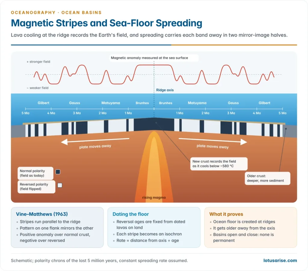
Vine and Matthews’ refinement (1963) — the critical confirming study: W.G. Vine and Matthews conducted a magnetic survey of the central part of the Carlsberg Ridge in the Indian Ocean in 1963, and computed theoretical magnetic profiles based on general magnetism principles. When they compared these computed profiles with the profiles of actual magnetic anomalies observed during the survey, they initially found a sizeable mismatch. However, when they re-plotted the profiles assuming alternating bands of normal and reversed magnetism, in separate stripes of about 20 km width on either side of the ridge, they found complete parallelism between the computed and observed profiles. This was the decisive confirmation of the theory.
The Vine-Matthews mechanism, explained fully: Vine and Matthews argued — building on the earlier ideas of Deitz and Hess — that when molten hot lava rises up along the mid-oceanic ridges via ascending thermal convection currents, and subsequently cools and solidifies, this newly formed rock also gets magnetised at the same time, in accordance with whatever the prevailing geomagnetic field direction happened to be at that moment. Because the Earth’s magnetic field periodically reverses its polarity, successive batches of newly formed crust get magnetised in alternating directions over time. As new lava continues to be upwelled at the ridge, it divides the previously formed basaltic layer into two equal, mirror-image halves that slide horizontally away from the ridge in opposite directions. This produces the characteristic striped pattern of alternating normal and reversed magnetic anomalies, symmetrically arranged on either side of the mid-ocean ridge.
Key validating studies: The findings of Cox, Doell and Dalrymple (1964), Opdyke (1966), and Heirtzler (1966) together validated four crucial facts: (i) There is genuine reversal in the Earth’s main magnetic field (known technically as the geocentric dipole magnetic field). (ii) Normal and reversed magnetic anomalies are found in a strictly alternating manner on either side of the mid-oceanic ridges. (iii) There is complete parallelism in the pattern of magnetic anomalies on either side of any given mid-oceanic ridge (i.e., the pattern on one side is a mirror image of the pattern on the other side). (iv) There is parallelism in the time sequence of palaeomagnetic epochs and events, calculated for up to 4.5 million years, based on the magnetism of basaltic and sedimentary rocks.
Rates of Plate Movement and Seafloor Spreading — Calculation Method: The rate of seafloor spreading is calculated using two related bases:
- (a) The age of isochrons — isochrons are lines that join points of equal-age magnetic stripes as plotted on a map.
- (b) The distance between two isochrons of known age difference.
Importantly, the rate of spreading calculated this way represents expansion on only one side of the mid-ocean ridge — you must double this figure to get the total rate of spreading of the ocean as a whole (since the ridge spreads symmetrically in both directions). For example, if the reported rate is 1.0 cm/year, the total spreading of the ocean is 1 + 1 = 2 cm/year.
Region-wise spreading rates (memorise these exact figures — high-yield for prelims and mains):
| Region | Rate (one side only) |
|---|---|
| Eastern Pacific Ridge (between equator and 30°S) | 6 to 9 cm/year (the maximum recorded rate anywhere) |
| Western North American coast | 2.5 to 3 cm/year |
| Southern Atlantic Ridge | 2 cm/year |
| Indian Ocean | 1.5 to 3 cm/year |
| Red Sea (Vine’s 1966 calculation) | ~1 cm/year (total ~2 cm/year); Alen and Morelli’s 1969 estimate: 1.1 cm/year (total 2.2 cm/year) |
| Gulf of Aden | 0.9 to 1.1 cm/year (total 1.8 to 2.2 cm/year) |
4.2 Palaeomagnetism
Palaeomagnetism refers to the preservation of magnetic properties in older rocks. When any rock — whether sedimentary or igneous — is formed, it gets magnetised in proportion to the iron content present in it, and this magnetism is “frozen” (preserved) once the rock cools below a critical temperature called the Curie point (generally around 600°C).
Definition and basic physics
Historical discovery: It was in 1600 AD that William Gilbert, physician to Queen Elizabeth I, first postulated that the Earth behaves like a giant magnet, with its magnetism produced in the Earth’s interior. The Earth’s magnetic field behaves like a giant bar magnet of dipoles located at the Earth’s core, aligned approximately along the Earth’s axis of rotation. Where the long axis of this notional bar magnet intersects the Earth’s surface, it produces two points called the north and south magnetic poles. Note the counter-intuitive but important detail: the Earth’s magnetic south pole is located near the geographic north pole, and vice versa — this is why an ordinary compass needle’s north-seeking end is attracted toward the geographic north (because opposite magnetic poles attract).
(1) Source of the Geomagnetic Field: The origin of the geomagnetic field is not related to the mantle — it is related to the Earth’s outer core. This is proven by the fact that there is a gradual westward migration of the geomagnetic field at a rate of about 0.18° per year, which is slower than the Earth’s own rotation. This proves that the core (which generates the magnetic field) rotates at a slightly different (slower) rate than the overlying mantle. Since a magnetic field cannot be a permanent, unchanging property of core material (it must be continuously produced and maintained), the mechanism must involve continuous generation of electrical currents — which requires materials of high electrical conductivity. Such conditions exist in the outer core, which is composed of metallic liquid material functioning as a “self-exciting dynamo.” The energy from the core is thus transformed into electrical currents, which, in association with the metallic liquid substances, produce the geocentric dipole magnetic field.
(2) Remanent Magnetism: The geocentric axial dipole field accounts for about 95% of the Earth’s total magnetism; the remaining portion consists of irregular, scattered, and weak local magnetic fields. There is no literal giant bar magnet inside the Earth — rather, there is a concentration of magnetism in core-region rocks, behaving as if there were a bar magnet. When hot, liquid lava/magma (with high ferromagnesian mineral content) cools and solidifies into igneous rock, it gets magnetised, and this record is preserved (frozen) in the rock — this preserved magnetism is called remanent magnetism or palaeomagnetism. Crucially, newly formed rocks are magnetised in the direction of the geomagnetic field that existed at the time of their formation — so the magnetic inclination/dip of a rock matches the geomagnetic field’s inclination/dip at that historical moment. The intensity of this remanent magnetism depends on (i) the mineral composition of the lava/magma and (ii) the intensity of the geomagnetic field at that time. Sedimentary rocks are also magnetised at the time of their formation, though the intensity depends on the amount of ferromagnesian minerals present, and this magnetism is sometimes destroyed by later chemical changes. Remanent magnetism is measured/recorded using a galvanometer.
(3) Reconstruction of Palaeomagnetism — the methodology: The reconstruction process involves collecting rock samples of the same age from different locations and determining/recording their magnetic orientation. Using a magnetometer, the magnitude, declination, and inclination of the local magnetic force are measured. It is assumed that, at the time of a rock’s magnetisation, the geomagnetic field was approximately dipolar, and there was rough correspondence between the average geomagnetic field position and the contemporary geographical poles.
Based on this assumption, the average palaeomagnetic inclination (dip) of rocks from a certain place and time is used to determine the latitude of that place at that historical time, using the formula:

where I = magnetic inclination and λ = latitude.
The latitude thus determined helps calculate the distance of the (then-existing) magnetic pole from the sample location, while the direction of the pole is determined from the palaeomagnetic declination (D). Combining distance and direction gives the position of the pole (relative to that sample location) at the time the rock was formed.
Sources of error and correction: Errors can arise because (i) only the geomagnetic field’s dipolar component is typically considered, ignoring minor field irregularities; (ii) sampled rocks might have undergone later magnetic alteration; (iii) orientation errors during sampling. To minimise these errors, multiple rock samples of the same age are collected, and the pole position is determined statistically as an average value.
(4) Reversal of Polarity: Palaeomagnetic study revealed that magnetisation in some rocks does not match the direction expected from the contemporary geomagnetic field — i.e., some rocks were found magnetised in the opposite direction to the “main” geomagnetic field. During the 1950s–60s, it was established that this reversely-magnetised phenomenon is not rare but is actually universal — roughly 50% of crustal rocks have been found magnetised opposite to the current field direction. Two possible explanations were considered:
- Self-reversal: the idea that individual rocks, over time, might spontaneously reverse their own magnetisation direction independent of the actual geomagnetic field. This possibility could not be substantiated by available field data, although Neel suggested a few theoretical mechanisms by which it might occur.
- Geomagnetic field reversal: the idea that the Earth’s actual magnetic field itself periodically reverses direction (north-south becomes south-north), and rocks simply record whatever field direction prevailed at the time of their formation. This is the mechanism that is generally accepted by most scientists. Field reversal is believed to occur at broadly regular (though not perfectly periodic) intervals.
Scientists have measured magnetic polarity of rocks going back 4.5 million years, establishing a definite, well-calibrated time sequence — rocks formed during the same time period, on any continent, show the same polarity, which is itself a powerful confirming piece of evidence for the global (not local) nature of geomagnetic reversal.
(5) Polar Wandering and its Resolution: The palaeomagnetic reconstruction method allows scientists to determine where the magnetic pole appeared to be located at various points in the geological past, for different continents. This produces “polar wandering curves” for each continent.
The critical logical test is this: if there had been no continental drift, then the polar wandering curves of different continents, for the same time period, should be identical to each other (since the poles and continents would have maintained the same relative positions throughout). But if continental drift did occur, then these curves should be different for each continent (since the continents’ relative positions to the poles changed over time).
When actually plotted, the polar wandering curves for different continents, for the same time period, were found to differ considerably from each other. This proves conclusively that it is not the poles that moved — it is the continents that changed their relative positions, while the magnetic poles remained comparatively stable (near the rotational axis). This is the final, decisive resolution to Wegener’s unresolved “polar wandering” confusion, and it simultaneously validates: (i) the fact of continental drift itself, (ii) the disruption of Wegener’s Pangaea, and (iii) the large-scale separation and displacement of continents.
5. The Chronological/Evolutionary History Of Ocean Basins
Although the precise, evidence-based sequence of continental displacement (based on palaeomagnetism and seafloor spreading data) is only reliably available for the last 200 million years, the general mechanism of plate tectonics — combined with corroborating continental geological evidence — allows scientists (notably Valentine and Moores, 1970, and Hallam, 1972) to reconstruct the earlier sequence of events as well.
5.1 The Two-Pangaea Model
- ~700 million years ago: All landmasses were united into a single giant supercontinent, referred to as Pangaea I.
- ~600–500 million years ago: Pangaea I broke apart due to thermal convective currents originating from within the Earth (most likely the mantle), and the resulting landmasses drifted apart from each other.
- These landmasses were subsequently reunited through further plate motions into a second single landmass known as Pangaea II, roughly 300–200 million years ago.
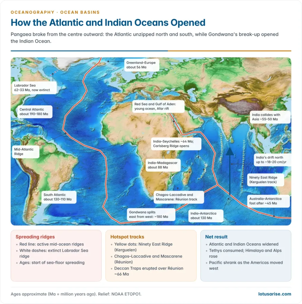
- According to A. Hallam, this second Pangaea began to break apart again during the early Jurassic period, with north-western Africa separating from North America.
5.2 The Detailed Break-up Sequence
- The zone of seafloor spreading continued to extend both northward and southward from the initial rift.
- The separation of South America and Africa was accomplished during the middle Cretaceous period.
- North America and Europe began moving apart from each other around the same broad period.
- The opening of the North Atlantic occurred in multiple distinct phases, not as a single event:
- After North America separated from Africa, Europe and Greenland broke away from Labrador during the late Cretaceous period (~80 million years ago), forming the Labrador Sea as a northern extension of the growing Atlantic Ocean.
- The Rockall Plateau separated from Greenland during the Tertiary period (~60 million years ago).
- The Labrador Sea and North Atlantic continued expanding between Europe and Greenland up to the middle Miocene period, as the European and American plates continued moving eastward and westward respectively.
- Spreading of the Labrador Sea stopped by the middle Miocene period (~47 million years ago), but the North Atlantic continued to expand and, notably, is still expanding today (has been continuously expanding for the last ~200 million years).
5.3 The Indian Ocean’s Evolution
- The Indian Ocean did not exist before the Cretaceous period.
- The Indian plate began moving southward (away from Africa) through the “Tethys Sea,” while the Australian-Antarctic plates also broke away from the African plate and moved southward, during the Cretaceous period.
- Dan McKenzie and John Sclater, using magnetic anomaly data, reconstructed the chronological sequence of the Indian Ocean’s evolution. According to their reconstruction, the Indian plate moved northward at a rate of about 18 cm/year during the early Tertiary period, but this rapid movement stopped during the Eocene period — precisely when the Indian plate’s northward journey ended in collision with the Asian/Eurasian plate, forming the Himalayas (the continent-continent collision case discussed in Section 3.3).
- At roughly the same time, Antarctica broke away from Australia.
- As a net consequence of the simultaneous expansion of the Atlantic and Indian Oceans, the Pacific Ocean began to shrink in size — since the total surface area of the Earth is fixed, expansion in one ocean basin must be compensated by contraction in another, and the Pacific (via subduction along its margins) is the ocean that has been “absorbing” this contraction.
5.4 The Mediterranean and Tethys Sea
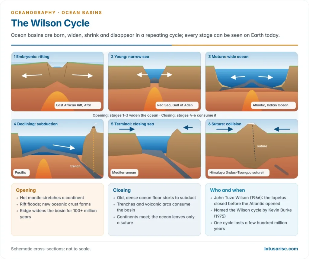
The Mediterranean Sea is understood to be the shrunken residual remnant of the once-vast Tethys Sea, which formerly separated Lauratia (north) from Gondwanaland (south) in the Pangaea reconstruction. As Africa and Eurasia converged (part of the same broad convergence that produced the Alpine-Himalayan mountain chain), the Tethys Sea was progressively squeezed and closed, leaving the much-reduced Mediterranean as its surviving fragment today.
5.5 Regional Case Studies (Detailed — each is independently examinable)
Red Sea and Gulf of Aden: The Red Sea is a classic textbook example of an axial trough located between Africa and the Arabian Peninsula. Surveyed magnetic anomalies in this region show a pattern of stripes similar to those found in true ocean basins — even though the Red Sea is a comparatively young and narrow feature — confirming that it is a genuine site of active seafloor spreading, essentially a nascent ocean basin.
- F.J. Vine (1966) calculated the Red Sea’s spreading rate, based on magnetic anomaly data, at about 1 cm/year on each side (2 cm/year total), sustained over the past 3–4 million years.
- Alen and Morelli (1969) recalculated this at 1.1 cm/year per side (2.2 cm/year total).
- The Gulf of Aden’s spreading rate, similarly calculated from magnetic stripe data, is 0.9 to 1.1 cm/year per side (1.8 to 2.2 cm/year total).
- Geologically, the Red Sea and Gulf of Aden sit at the junction of three plates: the Nubian plate, the Somali plate, and the Arabian plate. The Nubian and Somali plates are themselves separated by the Ethiopian Rift/Fault. This makes the region a classic triple junction.
Gulf of California and the San Andreas Fault: The Pacific Ocean is described as a “waning” ocean — i.e., one that is continuously contracting in size, because of the gradual westward encroachment of the American plates via subduction along its margins. It is believed that, similar to the Mid-Atlantic Ridge, there might once have been a continuous mid-oceanic ridge within the Pacific Ocean as well, but this has now been substantially deformed/disrupted by subsequent plate movement.
- A magnetic survey of the Gulf of California revealed a clear striped magnetic anomaly pattern, validating two important facts: (i) the East Pacific Rise (ridge) is located within/extends into the Gulf of California, and there has been continuous spreading of the Gulf along this ridge for the past four million years; and (ii) Baja California (the Californian peninsula) was previously joined to mainland North America, but later broke away from the continent due to this ongoing seafloor spreading — Baja is thus, in effect, a “rider” on the Pacific plate being carried away from the North American plate.
- The San Andreas Fault in California is the classic example of a conservative/transform plate boundary, described specifically as a “ridge-to-ridge transform fault” (it connects the East Pacific Rise segment in the Gulf of California with the Juan de Fuca/Mendocino ridge segment further north), where the Pacific Plate and North American Plate slide past each other laterally.
Iceland — a “living laboratory” of seafloor spreading: Iceland presents an ideal natural example of seafloor spreading in action, because it is physically situated astride the Mid-Atlantic Ridge — the ridge (locally called the Reykjanes Ridge) passes directly through the middle of the island, and magma continuously upwells along this axis.
- The eruption of the Helgafell volcano in 1973 provided direct observational evidence in support of ongoing spreading.
- Iceland’s surface area is continuously growing due to fresh basaltic lava — it is estimated the island has grown by about 400 km since the beginning of the Tertiary period (65 million years ago), indicating an average growth rate of roughly 0.6 cm/year.
- Critically, the age of lava increases with distance from the ridge: lava close to the ridge axis is as young as 2 million years, while lava at the outer margins of the island is as old as 65 million years — this age gradient is a direct, visible demonstration of the spreading mechanism.
Volcanic Islands of the Atlantic — Age-Distance Relationship: The volcanic islands scattered across the floor of the Atlantic Ocean are, without exception, associated with the Mid-Atlantic Ridge system. The most active volcanic islands are found nearest to the ridge (where magma supply is freshest), while dormant and extinct volcanoes are found at the farthest distance from the ridge (where the magma supply has long since been cut off by continued spreading).
- The oldest lava of the Azores islands (located close to the Mid-Atlantic Ridge) is about 4 million years old.
- The oldest lava of Cape Verde (located near the African coast, i.e., farthest from the ridge) is about 120 million years old. This confirms a clean, direct relationship: distance from ridge is proportional to the age of the underlying volcanic rock, exactly as predicted by the seafloor spreading mechanism.
Hawaiian Islands — the Hotspot/Mantle Plume Exception: The Hawaiian volcanic chain presents an interesting case that does not fit neatly into the standard plate-boundary framework (since Hawaii is located in the middle of the Pacific plate, far from any plate boundary), and the problem is resolved by invoking the concept of a stationary mantle plume (“hotspot”).
- Hawaii is understood as the south-eastern extension of a much longer chain — the Midway Island–Emperor Seamounts–Kamchatka Island Arc system.
- Hawaii itself, located far from the East Pacific Ridge, is characterised by currently active volcanism, whereas the other islands in this chain (further along, closer to Kamchatka) are dominated by dormant volcanoes with ancient lava (25 to 75 million years old).
- The explanation: there is believed to be an active mantle plume (a fixed, deep magma source) located beneath present-day Hawaii, which has continuously supplied molten magma to the surface for the last 70 million years. Because of ongoing plate movement, the Pacific oceanic floor (after separating from the East Pacific Ridge) has continued to move in a north-westerly direction at a rate of about 9 cm/year. As the plate moves over the stationary plume, the volcanic peak sitting above the plume also appears to migrate north-westward relative to the plume — but in reality, it is being carried away by plate motion while the plume itself stays fixed. The plume continuously “burns through” the moving plate, creating a fresh active volcano at the current location (Hawaii), while all previously formed volcanoes, having moved away from the stationary magma source, become progressively dormant, extinct, and eventually eroded/subsided into seamounts. This is the origin of the entire linear Hawaiian–Emperor seamount chain, and it is a widely cited example in mains answers on intraplate volcanism.
6. Seamounts And Tablemounts (Guyots)
Seamounts and tablemounts (guyots) are significant, mobile topographic features of volcanic origin found on ocean floors. They are direct results of plate movement and constitute physical “witnesses” of seafloor spreading — in effect, they are testimony to plate tectonics in action.
Seamounts:
- Tall volcanic peaks with a cone-shaped (conical) top.
- Generally not visible above sea level, though occasionally they do project above the sea surface.
Tablemounts / Guyots:
- Flat-topped volcanic peaks, named after the Swiss scientist Arnold Guyot.
- Always submerged, and characteristically covered with shallow-water deposits on their flat tops.
- It is believed guyots were originally conical in shape (like seamounts) but were subsequently flattened by marine (wave) erosion while they were still near sea level, before eventually subsiding below the surface as the seafloor spread and carried them away from the ridge/magma source.
The origin of both seamounts and guyots is directly associated with tectonic activity occurring at mid-ocean ridges, which represent active spreading zones caused by divergent plate movement, itself driven by divergent thermal convective currents originating within the Earth’s mantle.
Common origin mechanism
Detailed formation sequence:
- Active volcanoes form near mid-oceanic ridge crests, associated with the rising thermal convection currents there.
- As two oceanic plates diverge from the ridge crest, the confining pressure of the overlying (superincumbent) load is released, lowering the melting point of mantle material and causing partial melting of the upper mantle, forming tholeiite basalt.
- This basalt rises through the ascending convection currents and appears as fissure-type flow of basaltic lava at the surface.
- After cooling and solidification, this forms new oceanic crust, and the accompanying volcanic activity builds up a conical volcanic peak (seamount) near the ridge.
- As seafloor spreading continues, these volcanic peaks are gradually carried away from the ridge crest and its magma source.
- Once they move far enough away, the magma supply is effectively cut off, and volcanic activity ceases — the peak becomes dormant/extinct.
- If the peak had been close enough to sea level, wave erosion flattens its top, producing a guyot; if it remains fully submerged throughout, it stays a conical seamount.
- Not all volcanic peaks submerge completely — a few project as much as 1,500 to 3,000 m above sea level, remaining visible as true volcanic islands (rather than becoming fully submerged seamounts/guyots).
6.1 Island Arc Volcanism (Related but Distinct Phenomenon)
Island arcs, together with their associated oceanic trenches, form via a different mechanism — not divergent seafloor spreading, but convergent subduction. When an oceanic plate is subducted beneath a continental (or another oceanic) plate, seismic shocks and frictional heat are generated at depths of around 700 km, due to the friction between the continental plate and the subducted oceanic plate. This friction and heat causes melting of the upper mantle, the basaltic oceanic crust, and overlying sediments together, producing magma of a distinctly different composition from ridge-derived magma.
Composition difference (important distinguishing fact):
- Volcanic peaks of island arcs are characteristically formed of sodium-rich basalt/andesite, which is covered with andesite — a rock of relatively lower density but richer in silicon compared to the underlying basalt. This sodium-rich basalt forms specifically because the volcanic eruption is occurring within an oceanic-water environment.
Two competing theories on the origin of the andesite-dacite-rhyolite suite (associated with the circum-Pacific “Ring of Fire” fold mountain chain):
- Ringwood (1974): proposed that andesite-dacite-rhyolite rocks form due to partial melting of amphibolite in the subducted Benioff zone, combined with the melting of quartz eclogite at greater depth within the mantle.
- Gilluly: proposed instead that these rocks form due to partial melting of oceanic tholeiite, amphibolite, or eclogite, mixed with ocean-floor sediments such as sandstone, chert, and radiolarian ooze.