

- The Indian Ocean is the third largest ocean, about 70.6 million km² (roughly a fifth of the world ocean) with a mean depth of about 3,740 m. Most of it lies in the Southern Hemisphere.
- It is land-locked in the north. Asia closes it at about 30°N, barely beyond the Tropic of Cancer, and the Indian Peninsula splits this northern end into the Arabian Sea and the Bay of Bengal. In the south it opens widely to the Atlantic and Pacific.
- By convention its boundary with the Atlantic runs south from Cape Agulhas along 20°E, and its boundary with the Pacific runs south from Tasmania along about 147°E.
- Most of its shores are rigid blocks of Gondwanaland (Africa, Arabia, the Deccan, Western Australia). Only the Sumatra–Java arc in the north-east, fringed by young fold mountains, is an active margin.
- It is the youngest of the three major ocean basins, opened as Gondwana broke up and India drifted north. Hence its forked ridge, hotspot ridges, microcontinents and giant fans.
Shape, Margins and Shelves
Three-part layout
- The ridge system divides the floor into an African (western), an Australian (eastern) and an Antarctic (southern) part.
- The western part is broken by ridges, banks, microcontinents and islands, fragments left behind as India pulled away.
- The eastern part is deeper and smoother, with long basins and few islands.
- An older scheme names three zones: an island-studded western zone, a central ridge zone and a deeper eastern zone with narrow, steep shelves.
- Compared with the Pacific and the Atlantic, it has fewer marginal seas, fewer islands and only one major trench.
| Feature | Indian Ocean | Atlantic | Pacific |
|---|---|---|---|
| Mid-ocean ridge | Inverted Y with a triple junction | S-shaped, central | Off-centre East Pacific Rise |
| Trenches | One major (Java) | Two short (Puerto Rico, South Sandwich) | Many, round the rim |
| Margins | Mostly passive plateau edges | Mostly passive | Mostly active |
| Marginal seas | Few | Several large | Many, behind island arcs |
| Islands | Few; continental and hotspot | Few; ridge and continental | Very many; arcs, hotspots, atolls |
Continental shelves
- Shelves are mostly narrow, because plateau edges and rifted margins drop steeply to deep water. They widen only off big rivers and stable lowlands.
- India’s west coast shelf is far wider than its east coast shelf.
- The western shelf is widest off Gujarat and Mumbai and narrows towards Kerala; its break lies at about 60–150 m. The Gulfs of Kachchh and Khambhat are drowned parts of it.
- The eastern shelf is narrow, and the slope plunges quickly off the deltas of the Ganga, Mahanadi, Godavari, Krishna and Kaveri.
- The Gulf of Mannar and Palk Bay share one shallow shelf with Sri Lanka, crossed by the shoals of Adam’s Bridge.
- Elsewhere:
- the Persian Gulf lies wholly on the shelf, about 50 m deep on average and about 90 m at most;
- the Sahul Shelf off north-western Australia is very broad;
- the Sunda Shelf lies mostly behind the arc, under the Java and South China seas, while the Indian Ocean side of Sumatra and Java is narrow and steep;
- the shelf is broader round Madagascar than along most of Africa;
- the Antarctic shelf is unusually deep (400–500 m), pressed down by ice.
- Coral reefs fringe many tropical shelves, and canyons such as the Swatch of No Ground in the Bay of Bengal and the Indus Canyon cut the outer edge and slope.
Economic significance of the shelf
- The shelf is the most productive part of the ocean floor: thick sediments trap hydrocarbons, rivers bring placers, and sunlit water supports fisheries.
| Resource | Main areas |
|---|---|
| Oil and gas | Persian Gulf; Mumbai High; Krishna–Godavari and Cauvery basins; NW Australian shelf |
| Placer minerals | Ilmenite, monazite and zircon sands (Kerala, Odisha); tin (Andaman Sea–Sunda region) |
| Fisheries | Upwelling coasts of Somalia, Oman and Kerala; Bay of Bengal shelf |
| Building material | Shelf sand, shell and reef limestone |
- The Persian Gulf holds the world’s largest cluster of oil and gas fields. India’s offshore output began with Mumbai High, found in 1974, and now includes Krishna–Godavari deep-water gas.
- Monazite in Kerala and Odisha sands is India’s source of thorium for its nuclear programme.
- Monsoon upwelling makes the Somali, Omani and Kerala shelves rich fishing grounds among the ocean’s marine resources.
- Coastal states hold sovereign rights over the shelf under UNCLOS, which makes its outer limit a strategic issue.
The Ridge System
Mid-ocean ridges: an inverted Y
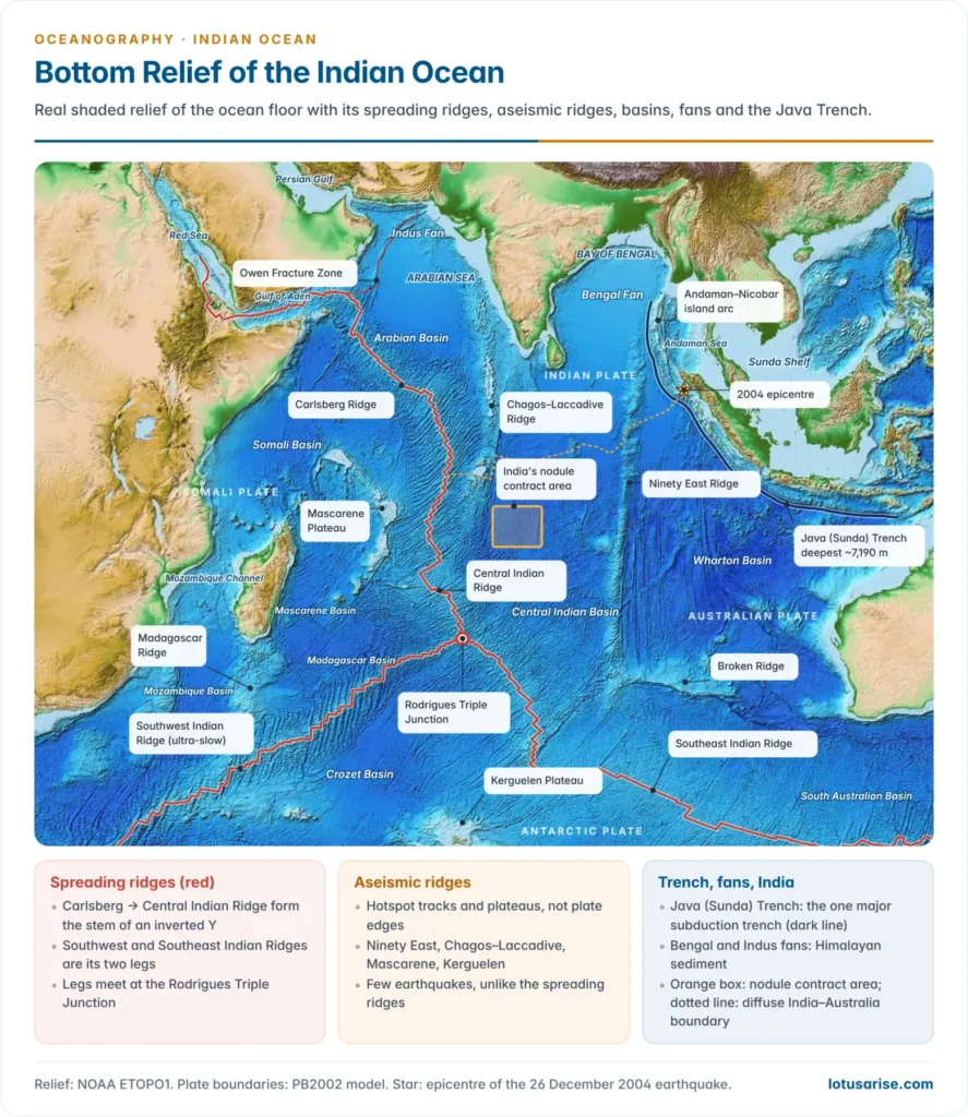
- The spreading ridges form an inverted Y:
- Stem: the Carlsberg Ridge runs south-east from the Gulf of Aden to near the equator and continues south as the Central Indian Ridge.
- Fork: at the Rodrigues Triple Junction (about 25.5°S, 70°E) it splits in two. All three arms are spreading ridges, so it is a ridge–ridge–ridge junction.
- Legs: the Southwest Indian Ridge runs to the South Atlantic and the Mid-Atlantic Ridge; the Southeast Indian Ridge runs south of Australia towards the Pacific–Antarctic Ridge.
- These are divergent plate boundaries where sea-floor spreading makes new crust, with rift valleys, transform faults and shallow earthquakes.
- The Owen Fracture Zone links the Carlsberg Ridge to the Sheba Ridge of the Gulf of Aden and on to the Red Sea rift.
- The Amsterdam and St Paul islands are volcanic peaks on the Southeast Indian Ridge.
| Ridge | Plates separated | Spreading | Note |
|---|---|---|---|
| Carlsberg | Indian–Somali | Slow | Rugged, deep rift valley |
| Central Indian | Capricorn/Indian–Somali | About 5 cm/yr | Hydrothermal vents, sulphides |
| Southwest Indian | Somali/African–Antarctic | About 1.6 cm/yr | Ultra-slow, among the slowest on Earth |
| Southeast Indian | Australian–Antarctic | About 6 cm/yr | Fastest, smoothest leg |
- Spreading rate shapes the relief. The slow Carlsberg and ultra-slow Southwest Indian ridges are rugged, with deep axial valleys; the faster Southeast Indian Ridge has a smoother crest.
- South of Australia it has one deep, rough stretch over cooler mantle, the Australian–Antarctic Discordance.
- The ridges carry hydrothermal vents and sulphide deposits, such as the Kairei field on the Central Indian Ridge. China (2011) and India hold sulphide exploration contracts on them.
- The old single “Mid-Indian Ridge” from Kanyakumari to Antarctica joined two different things. Its northern part, the Chagos–Laccadive Ridge, is not a spreading ridge.
| Older regional name | Present understanding |
|---|---|
| Laccadive–Chagos (Maldive) Ridge | Aseismic hotspot ridge, not a spreading ridge |
| Socotra–Chagos Ridge | Carlsberg Ridge (spreading) |
| Chagos–St Paul Ridge | Central Indian Ridge (spreading) |
| Amsterdam–St Paul Plateau | Crest of the Southeast Indian Ridge |
| Seychelles–Mauritius Ridge | Mascarene Plateau (microcontinent and hotspot banks) |
| Madagascar and Prince Edward–Crozet ridges | Aseismic plateaus beside the Southwest Indian Ridge |
| Kerguelen–Gaussberg Ridge | Kerguelen Plateau (large igneous province) |
- The old Indo-Australian Plate has split into Indian, Capricorn and Australian plates along a wide zone of diffuse deformation in the Central Indian and Wharton basins.
- The April 2012 Wharton Basin earthquake (Mw 8.6), the largest strike-slip and intraplate earthquake ever recorded, marks this boundary in the making. An Mw 8.2 shock followed within hours.
Aseismic ridges and plateaus
- Aseismic ridges are submarine ridges and plateaus with no earthquakes, because they are not plate boundaries. Most are hotspot tracks or continental fragments of Gondwana.
| Feature | Location and size | Origin |
|---|---|---|
| Ninety East Ridge | About 5,000 km along 90°E, 9°N to 31°S | Kerguelen hotspot track, about 82–37 million years old, oldest in the north |
| Chagos–Laccadive Ridge | About 2,550 km along 73°E, 14°N to 10°S | Réunion hotspot track; volcanism about 66 million years ago, with the Deccan Traps |
| Mascarene Plateau | About 2,000 km arc, Seychelles to Réunion | Granite microcontinent (Seychelles) in the north; hotspot banks (Saya de Malha, Nazareth) in the south |
| Kerguelen Plateau | Over 2,200 km long, about 1.2 million km² | Kerguelen large igneous province, with continental slivers |
| Broken Ridge | About 31°S, west of Australia | Rifted twin of the Kerguelen Plateau |
| Madagascar Ridge | South of Madagascar | Shallow submarine plateau |
Hotspot tracks: how India drew its ridges
- As the Indian Plate moved north, it passed over two mantle plumes. Each left a line of volcanoes whose ages fall towards the plume active today.
- Réunion track: the plume first erupted the Deccan Traps about 66 million years ago, then built the volcanic banks of the Laccadives, Maldives and Chagos as India moved over it.
- About 35 million years ago the Central Indian Ridge crossed the plume. The track then continued on the African side as the southern Mascarene Plateau, Mauritius (about 8 million years old) and Réunion, still active.
- Kerguelen track: the plume erupted the Rajmahal Traps about 118 million years ago and built the Kerguelen Plateau. India’s drift then drew out the dead-straight Ninety East Ridge.
- The Southeast Indian Ridge split the plateau from Broken Ridge about 40 million years ago. The plume is still active under Heard Island.
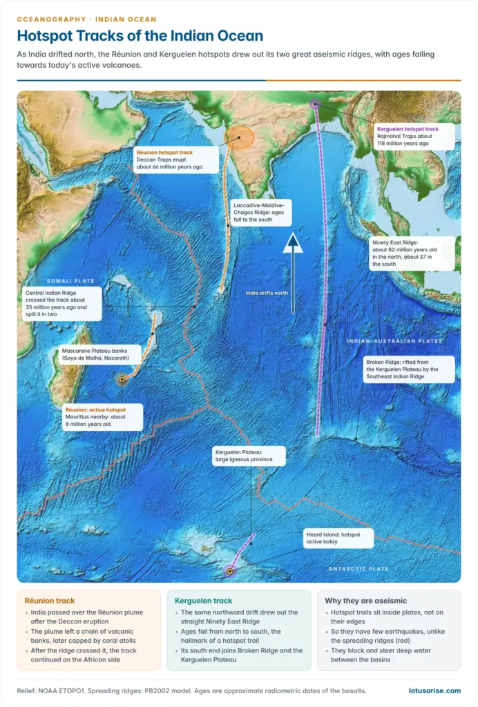
- The Lakshadweep, Maldives and Chagos atolls stand on the Chagos–Laccadive Ridge. Their coral caps grew as the volcanic banks sank, as the subsidence theory predicts.
- A 2024 dating study showed that the Kerguelen hotspot itself moved several hundred kilometres while it built the Ninety East Ridge.
- Continental fragments hide in the western floor:
- the granite Seychelles, split from India about 64 million years ago as the Carlsberg Ridge opened;
- the Laxmi Ridge, a continental sliver off India’s west coast;
- Mauritia, a buried microcontinent revealed in 2017 by 2.5–3-billion-year-old zircons in young Mauritian lavas.
- The 85°E Ridge in the Bay of Bengal is a second aseismic ridge, buried under the Bengal Fan; its origin is still debated.
Basins, Trenches and Fans
Ocean basins
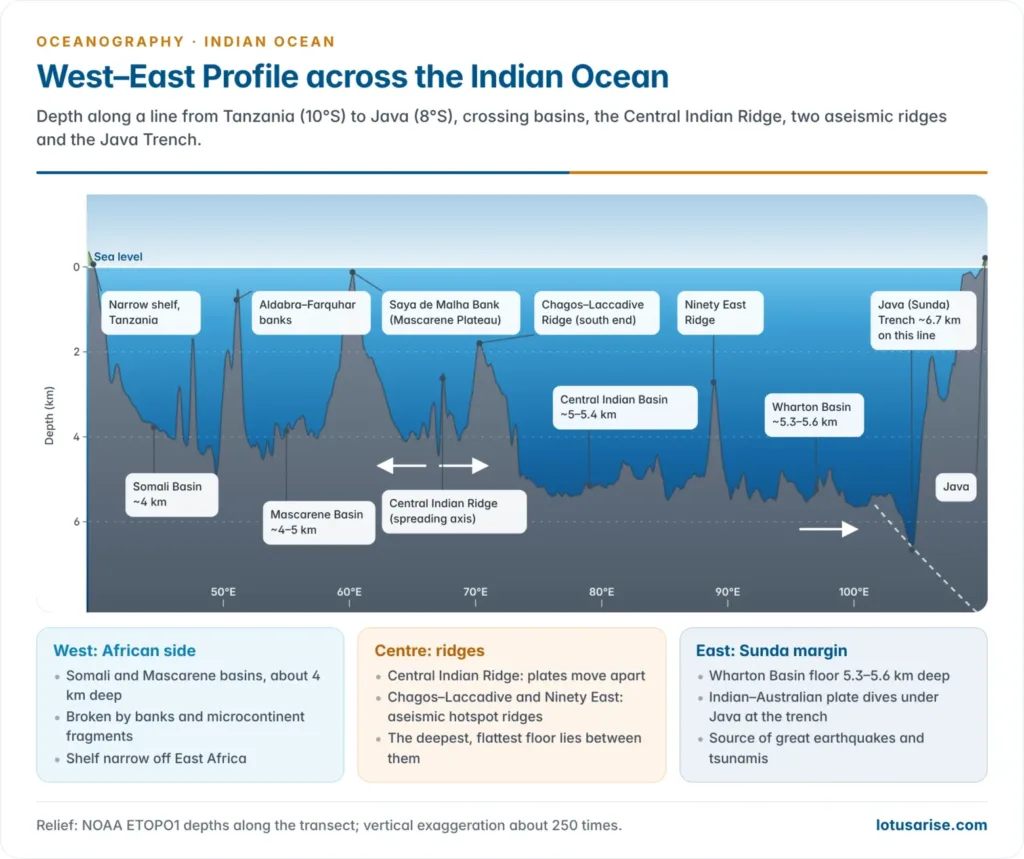
- The ridges enclose deep basins, mostly 4,000–6,000 m deep, floored by abyssal plains where sediment is thick and abyssal hills where it is thin. The western basins are smaller and broken; the eastern ones are larger and deeper.
- About half the floor is deep-sea plain. The main abyssal plains are the Somali, Ceylon (Sri Lanka), Indian (Central Indian) and Argo plains.
- The Argo Abyssal Plain off north-western Australia holds the oldest known Indian Ocean sediments, of Late Jurassic age, laid down when the ocean first opened there.
| Basin | Setting | Key features |
|---|---|---|
| Oman | Off the Gulf of Oman | Small basin north of the Owen Fracture Zone |
| Arabian | Between the Carlsberg and Chagos–Laccadive ridges | Partly buried by the Indus Fan |
| Somali | Off Somalia and Kenya | About 4–5 km deep |
| Mascarene | Between Madagascar and the Mascarene Plateau | Floor from the Madagascar–India break-up |
| Madagascar | South-east of Madagascar | Between the Central Indian and Madagascar ridges |
| Mozambique, Natal and Agulhas | Off south-east Africa | Bounded by the Mozambique and Madagascar ridges |
| Crozet | South of the Southwest Indian Ridge | Beside the Crozet and Kerguelen plateaus |
| Central Indian | Between the Chagos–Laccadive and Ninety East ridges | Distal Bengal Fan; nodules; diffuse deformation |
| Wharton (West Australian) | Between the Ninety East Ridge and Australia | Broad, deep; 2012 earthquake |
| South Australian | South of Australia | Australian–Antarctic rift floor |
| Enderby and South Indian (Australian–Antarctic) | Off Antarctica | Deep floor south of the ridge legs |
Trenches and deeps
- Trenches are rare, because nearly all the margins are passive. The one major trench is the Java (Sunda) Trench:
- about 3,200 km long, from off the Andamans past Sumatra and Java to the Lesser Sunda Islands;
- formed where the Indian and Australian plates subduct beneath the Sunda Plate, raising the Sumatra–Java volcanic arc;
- deepest south of Java at about 7,190 m, the deepest point of the Indian Ocean, measured on a crewed dive in April 2019 that replaced the older 7,450 m figure.
- The same survey put the Dordrecht Deep in the Diamantina Fracture Zone, off south-west Australia, at about 7,020 m.
- Lesser troughs include the Chagos and Amirante trenches.
- The Andaman–Nicobar Islands are the outer arc of the same subduction zone, continuing the Arakan Yoma. The Andaman Sea behind them is a back-arc basin.
- The 26 December 2004 earthquake (Mw about 9.1–9.3) began off north-western Sumatra and ruptured about 1,300 km of the megathrust to the Andamans. Its tsunami killed over 2.2 lakh people.
- The Andaman and Nicobar Islands sank by about 1 m. India’s tsunami warning centre at INCOIS, Hyderabad, followed in 2007.
- A second great quake (Mw 8.6) struck off Nias in March 2005, on the next segment south.
Bengal and Indus fans
- The ocean holds the two largest submarine fans on Earth, built of Himalayan sediment by turbidity currents:
- the Bengal Fan, about 3,000 km long, about 1,000 km wide and up to about 16.5 km thick, from the Swatch of No Ground into the Central Indian Basin;
- the Indus Fan in the Arabian Sea, with over 9 km of sediment near the slope.
- Their layers record Himalayan uplift and monsoon erosion; ocean drilling in 2015 recovered a Bengal Fan record back to the late Oligocene.
Islands
- Islands are fewer than in the Pacific and lie mostly in the north and west; the deep east is almost empty, except for Christmas Island and the Cocos (Keeling) Islands.
| Type | Examples | Origin |
|---|---|---|
| Continental | Madagascar, Sri Lanka, Socotra, Zanzibar, Seychelles | Fragments of Gondwana or the shelf |
| Volcanic | Mauritius, Réunion, Comoros, Kerguelen, Heard, Crozet, Prince Edward | Hotspots and ridges; Réunion and Heard still active |
| Coral | Lakshadweep, Maldives, Chagos, Aldabra, Cocos (Keeling) | Reefs on subsided volcanic ridges |
| Island arc | Andaman–Nicobar, Mentawai | Outer arc of the Sunda subduction zone |
- Mauritius and Réunion are steep volcanic cones rising from the deep floor.
- Behind the Andaman arc rise Barren Island, India’s only active volcano (minor eruptions in September 2025), and dormant Narcondam.
- The low coral islands of Lakshadweep and the Maldives are highly exposed to sea-level rise.
Marginal seas
- True marginal seas are few, because the coasts are mostly plateau edges without island festoons. Only the Red Sea and the Persian Gulf are fully enclosed.
| Sea | Nature |
|---|---|
| Red Sea | A young ocean in the Africa–Arabia rift, over 2,700 m deep; a shallow sill at Bab-el-Mandeb |
| Persian Gulf | Shallow basin on continental crust in front of the Zagros; narrow Strait of Hormuz |
| Gulf of Aden | Spreading gulf along the Sheba Ridge |
| Andaman Sea | Back-arc basin behind the Andaman–Nicobar arc |
| Arabian Sea, Bay of Bengal | Open northern arms of the ocean, not true marginal seas |
| Mozambique Channel | A broad strait between Africa and Madagascar |
- The Red Sea is an ocean being born, with hot (about 60°C) brines over metal-rich muds in its axial trough. The Hanish Sill near Bab-el-Mandeb is only about 137 m deep.
- The Persian Gulf is a shallow foreland trough; the Oman Peninsula pinches the Strait of Hormuz to about 39 km.
India and the Indian Ocean Floor
| Interest | Facts |
|---|---|
| Exclusive Economic Zone | Over 2 million km², nearly 30% round the Andaman and Nicobar Islands; coastline re-measured at 11,098.81 km (2025) |
| Extended continental shelf | Claim beyond 200 nautical miles before the UN Commission; revised central Arabian Sea submission in 2025 |
| Polymetallic nodules | First registered pioneer investor (1987); ISA contract from 2002, extended 2022, for 75,000 km² in the Central Indian Ocean Basin, about 366 million tonnes |
| Polymetallic sulphides | 10,000 km² around the Central and Southwest Indian ridges (2016); 10,000 km² on the Carlsberg Ridge (2025) |
| Cobalt crusts | Application for the Afanasy-Nikitin Seamount (2024) |
| New features | Ashoka Seamount, Kalpataru and Chandragupt ridges, found by Indian surveys and named in 2024 |
- The nodule field lies at about 5,000 m, rich in copper, nickel and cobalt.
- Under the Deep Ocean Mission (2021), NIOT, Chennai, is building the crewed submersible Matsya-6000 and a nodule-mining system, while NCPOR, Goa, leads the ridge-sulphide surveys.
- Matsya-6000 passed harbour wet tests in 2025, with a 500 m trial planned for 2026 before the 6,000 m dive. Two Indian aquanauts trained on French dives to about 5,000 m in August 2025.
Significance of the floor relief
- Resources: shelf oil, gas, placers and fish; deep-sea nodules, sulphides and crusts for India’s Blue Economy.
- Hazards: the Sunda subduction zone is the ocean’s earthquake and tsunami belt.
- Circulation: aseismic ridges and plateaus wall off the basins and steer Antarctic bottom water north through gaps.
- Climate archive: the Bengal and Indus fans store the record of Himalayan uplift and monsoon strength.
- Strategy: a UK–Mauritius treaty signed in May 2025 recognises Mauritian sovereignty over the Chagos while keeping the Diego Garcia base; the Andaman–Nicobar arc overlooks the Malacca approaches.
Previous Year Questions
2024With suitable sketches elaborate the bottom topography of the Indian Ocean.2009Examine economic significance of the resource of the Continental shelf of the Indian Ocean.2003Present a concise account of bottom relief of the Indian Ocean.




Great content and information as usual. You are blessing for geography optional students… thanks a lot sir/mam.
Most Welcome, Keep Reading.