

- An ocean current is a persistent, mainly horizontal flow of sea water along a fairly fixed path, much like a river running through the sea. Currents are the main way the ocean moves water, heat, salt, nutrients and organisms from one region to another.
- The sea moves in three ways. Ocean waves make water particles oscillate, tides raise and lower it once or twice a day, and only currents carry water over long distances.
- Ocean water moves both horizontally (currents) and vertically, where it rises (upwelling) or sinks (downwelling). The two are parts of one circulation.
- Because they redistribute heat, currents shape coastal climates, fisheries, navigation, fog and the behaviour of air masses.
Nature and Types of Ocean Currents
Characteristics
- Speed: most surface currents move at a few centimetres to about 30 cm per second. The fastest, such as the Gulf Stream, reach about 2–2.5 m/s at the surface.
- Volume: flow is measured in sverdrups (Sv), named after Harald Ulrik Sverdrup. One sverdrup is 1 million m³ of water per second, roughly the combined discharge of all the world’s rivers.
- Observation: currents are tracked by surface drifters, moored current meters, Argo floats and satellite altimetry.
- The SWOT satellite (launched December 2022) maps sea-surface height at a few kilometres’ resolution. Its data showed in 2025 that eddies and fronts 1–100 km across move more heat, carbon and nutrients between the surface and the deep sea than had been assumed.
Types of ocean currents
By temperature
- Warm and cold are relative terms. A current is warm if it is warmer than the water around it and the air above it, and cold if it is cooler.
- Warm currents flow from low to high latitudes. In low and middle latitudes they wash the east coasts of continents; in the high latitudes of the Northern Hemisphere they reach the west coasts (the North Atlantic Drift off Norway).
- Cold currents flow from high to low latitudes. They wash the west coasts in low and middle latitudes, and the east coasts in high northern latitudes (the Labrador and Oyashio currents).
| Feature | Warm current | Cold current |
|---|---|---|
| Direction | Poleward | Equatorward |
| Usual coast (low and mid latitudes) | East coast of continents | West coast of continents |
| Effect on coastal air | Warms and moistens it | Cools and dries it |
| Examples | Gulf Stream, Kuroshio, Brazil, Agulhas, East Australian | Canary, Benguela, Peru (Humboldt), California, Labrador |
By depth
- Surface currents occupy roughly the upper 400 m and hold about 10% of the ocean’s water. They are driven mainly by wind.
- Deep currents move the remaining 90% below the pycnocline. They are driven by density differences, which come from temperature and salinity, and form the thermohaline circulation.
By speed and form
| Type | Speed | Boundaries | Cause | Example |
|---|---|---|---|---|
| Drift | Slow, about 15–25 km a day | Broad, vague | Prevailing winds dragging the surface | North Atlantic Drift, West Wind Drift |
| Current | Faster, a few km an hour | More definite | Part of the circulation squeezed into a belt | Florida Current |
| Stream | Fastest, river-like | Sharp, especially on the landward side | Large volume confined to a narrow path | Gulf Stream |
By position in the circulation
- Equatorial currents flow westward under the trade winds. Between them, equatorial countercurrents flow eastward, and beneath them, equatorial undercurrents run east at about 50–200 m depth.
- The Pacific’s Cromwell Current was discovered by Townsend Cromwell in 1952.
- Western boundary currents (Gulf Stream, Kuroshio) and eastern boundary currents (Canary, California) form the sides of the gyres.
- Transverse currents link the two across the ocean: the North Atlantic Drift and the North Pacific Current under the westerlies.
Forces Behind Ocean Currents
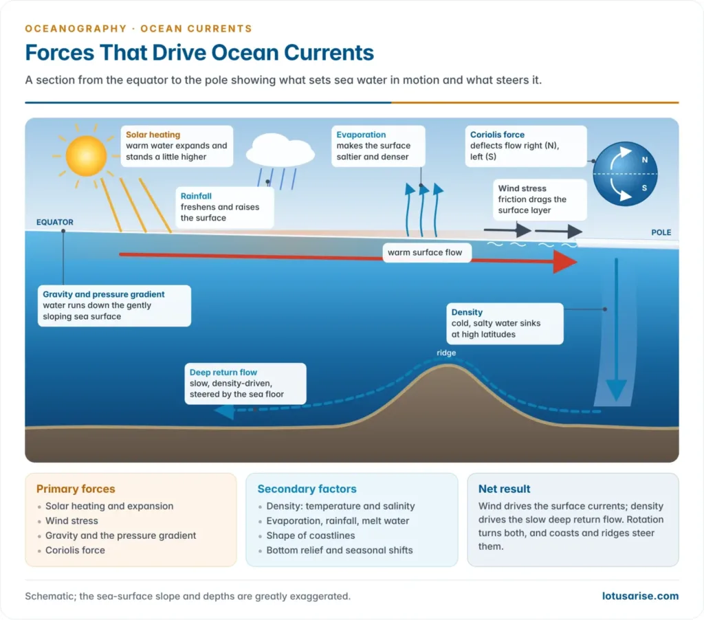
- No single cause explains any current. Wind, density, gravity and the Earth’s rotation act together, and coasts and the sea floor then steer the flow.
- Theory grew in stages. Karl Zöppritz (1878) first treated wind-driven currents mathematically but ignored the Earth’s rotation. Vilhelm Bjerknes (1898) gave the circulation theorem for density-driven flow. Vagn Walfrid Ekman (1905) added rotation to wind drift. Harald Sverdrup (1947), Henry Stommel (1948) and Walter Munk (1950) then explained the basin-wide gyres.
- Two groups of factors are usually distinguished:
| Generating (primary) forces | Modifying (secondary) factors |
|---|---|
| Solar heating and thermal expansion | Shape and direction of coastlines |
| Wind stress | Bottom relief: ridges, sills, shelves |
| Gravity and the pressure gradient | Seasonal shifts of winds and pressure belts |
| Coriolis force | Density differences from temperature, salinity, evaporation, rain and melt water |
Primary forces
Solar heating
- Heated water expands, so the warm low-latitude ocean stands slightly higher than the cool high-latitude ocean. Water tends to flow down this gentle slope.
Wind stress
- Wind blowing over water drags the surface by friction. The stress grows with the square of the wind speed, and a steady wind produces a surface current of about 2–3% of its own speed.
- The planetary winds set the broad pattern:
- the trade winds push the equatorial currents westward;
- the westerlies drive the eastward drifts of middle latitudes;
- the polar easterlies drive westward flow near Antarctica.
- Maps of planetary winds and surface currents therefore match closely. The wind supplies almost all the energy of the surface circulation.
- The clearest proof is the north Indian Ocean, where the currents reverse with the monsoon, eastward in summer and westward in winter.
Gravity and the pressure gradient
- Wherever the sea surface is tilted, gravity pulls water from the higher to the lower part. The resulting pressure gradient keeps currents moving after the wind that piled the water up has weakened.
- Atmospheric pressure tilts the surface too. Each hectopascal of extra pressure depresses the sea by about 1 cm.
- Currents that flow down such slopes are gradient currents. Martin Knudsen explained the outflow from the Baltic, where heavy river inflow and lower pressure keep the surface above that of the North Sea.
Coriolis force
- The Earth’s rotation deflects any moving water to the right in the Northern Hemisphere and to the left in the Southern Hemisphere. The effect was described by Gaspard-Gustave de Coriolis in 1835.
- The Coriolis force is zero at the equator and greatest at the poles, and it acts only on water that is already moving. It changes direction, not speed.
- It turns the wind-driven flow into closed loops (gyres) and produces the Ekman spiral.
Secondary forces
Temperature, salinity and density
- Cold or salty water is dense and sinks; warm or fresh water is light and spreads over it. Differences in salinity and sea-water density therefore drive both vertical movement and slow horizontal flow.
- Evaporation and rainfall alter both level and density. Where rain exceeds evaporation, as near the equator, the surface is higher and fresher; under the subtropical highs evaporation makes it saltier and denser.
- Enclosed seas show the mechanism best:
- at Gibraltar, light Atlantic water flows in at the surface while dense, salty Mediterranean water flows out below;
- the Red Sea exchanges with the Gulf of Aden the same way through the Bab-el-Mandeb;
- the Baltic reverses the pattern, with fresh surface water flowing out and salty North Sea water creeping in at depth.
- Melt water lowers salinity and raises the sea level locally. It helps drive the East Greenland Current.
Shape of coastlines
- A coast lying across a current splits or turns it parallel to the shore.
- The South Equatorial Current of the Atlantic divides at Cape São Roque in Brazil. One branch feeds the Caribbean and the Gulf Stream system; the other turns south as the Brazil Current.
- The Gulf Stream follows the trend of the US east coast to Cape Hatteras before turning out to sea.
Bottom relief
- Ridges, sills and shallow shelves steer currents, especially deep ones and those of middle and high latitudes.
- The Wyville Thomson Ridge between Scotland and the Faroes deflects the North Atlantic Drift.
- The Antarctic Circumpolar Current swings sharply round the Macquarie Ridge south of New Zealand.
- The shallow Bering Strait, only about 50 m deep, allows little exchange between the Pacific and the Arctic. Sills near Iceland hold back the dense bottom water of the Arctic basin.
Seasonal changes
- The seasonal shift of the pressure and wind belts moves the equatorial currents north and south with the sun, and in the monsoon realm reverses whole current systems.
Dynamics of Wind-Driven Circulation
Ekman spiral and Ekman transport
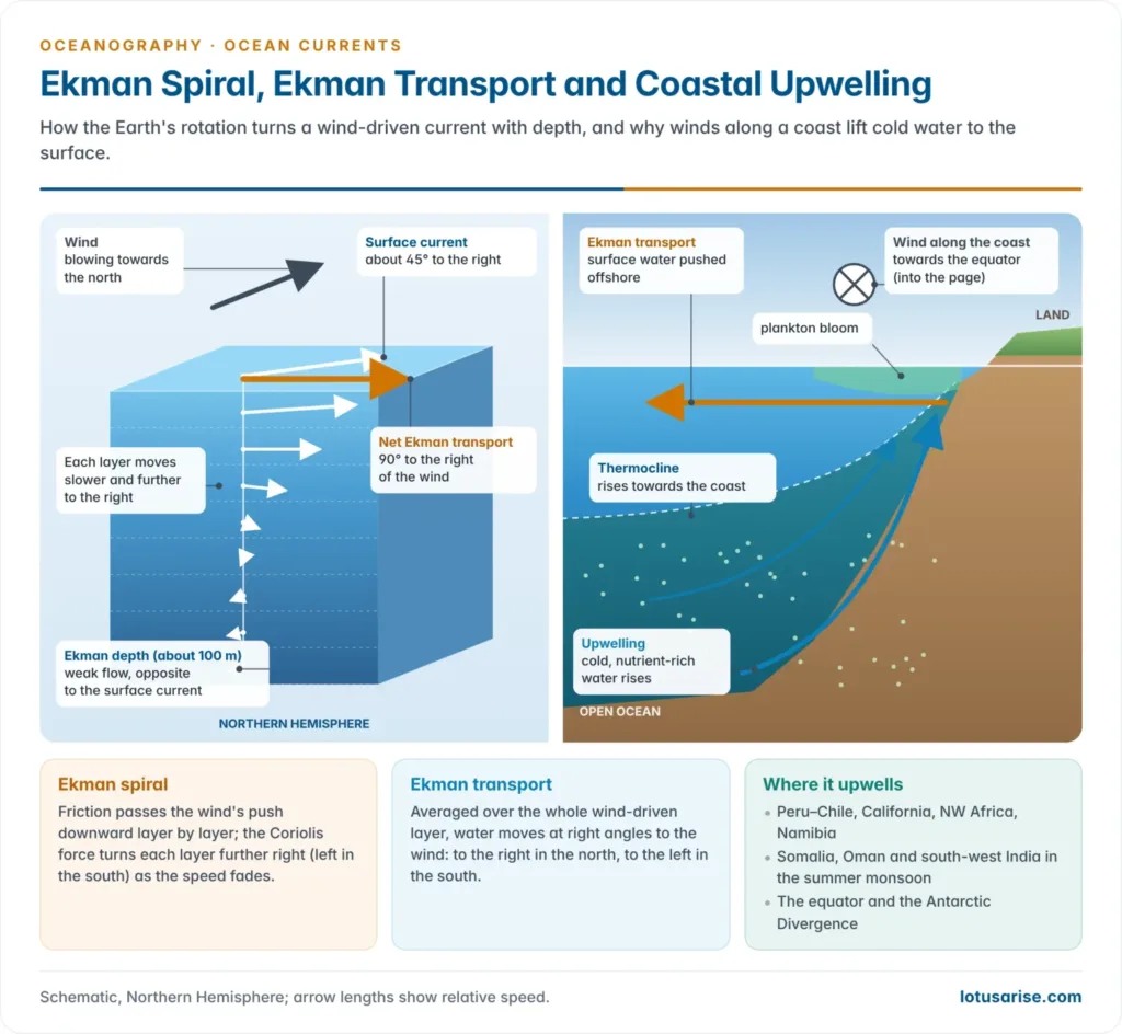
- During the Fram expedition (1893–96), Fridtjof Nansen noticed that drifting sea ice moved 20–40° to the right of the wind, not with it.
- Vagn Walfrid Ekman (1905) explained this:
- the wind drags the top layer, which the Coriolis force deflects about 45° to the right in the Northern Hemisphere (to the left in the Southern);
- each layer drags the one below, which moves more slowly and further to the right;
- the current vectors therefore trace a spiral that fades out at the Ekman depth, commonly about 100 m, where the weak flow runs opposite to the surface current.
- The net movement of the whole wind-driven layer, the Ekman transport, is at right angles to the wind: to the right in the Northern Hemisphere and to the left in the Southern.
- The real ocean departs from the ideal. Surface currents usually lie less than 45° from the wind, and the transport less than 90°, especially in shallow coastal water, where friction with the bottom keeps the flow closer to the wind direction.
Upwelling and downwelling
- Upwelling brings cold, nutrient-rich water from below the thermocline to the surface. Downwelling carries surface water down, taking oxygen to the deep sea but leaving the surface poor in nutrients.
- Coastal upwelling occurs where Ekman transport moves surface water away from the coast. This happens on the eastern margins of oceans, where winds blow towards the equator along the shore:
- Peru and Chile (Humboldt), California, North-West Africa (Canary) and Namibia (Benguela) form the four great eastern boundary upwelling systems. Together they cover about 1% of the ocean but supply up to a fifth of the world’s wild fish catch.
- In the summer monsoon the south-westerlies drive strong upwelling off Somalia and Oman, and a weaker band off south-west India. This band supports Kerala’s oil sardine and mackerel.
- Open-ocean upwelling occurs where currents diverge:
- along the equator, where Ekman transport moves water north and south away from the line;
- at the Antarctic Divergence, between the eastward West Wind Drift and the westward East Wind Drift.
- Downwelling occurs where surface water converges: along coasts where the wind drives water shoreward, and in the centres of subtropical gyres, where Ekman flow piles water up and forces it down (Ekman pumping). Subpolar gyres do the reverse and draw deep water up.
Geostrophic currents
- In a subtropical gyre, Ekman transport pushes surface water towards the centre. It builds a broad hill of water about a metre higher than the gyre’s edges.
- Gravity pulls water down the slope of the hill, and the Coriolis force turns it until the two forces balance. The water then flows along the slope, round the hill, not down it. This is a geostrophic current.
- Most large currents are partly wind-driven and partly geostrophic. The geostrophic part keeps a gyre turning even when the wind slackens.
- The calm, warm, clear centre of the North Atlantic hill is the Sargasso Sea, named after its floating Sargassum weed.
Gyres
- A gyre is a closed loop of surface currents round an ocean basin, centred on the subtropical high-pressure belt.
- There are five great subtropical gyres: the North and South Atlantic, the North and South Pacific, and the Indian Ocean.
- Each has four limbs: a westward equatorial current, a poleward western boundary current, an eastward transverse current under the westerlies, and an equatorward eastern boundary current.
- Subpolar gyres turn the other way under the subpolar lows: the Alaska Gyre, the Labrador–Irminger Gyre, and the Weddell and Ross gyres off Antarctica.
- The Antarctic Circumpolar Current has no land in its way. It flows unbroken round the globe and is the largest current by volume, more than four times the Gulf Stream.
- Gyres concentrate floating debris. The Great Pacific Garbage Patch in the North Pacific gyre is the best-known accumulation of plastic.
| Feature | Northern Hemisphere gyre | Southern Hemisphere gyre |
|---|---|---|
| Rotation | Clockwise | Anticlockwise |
| Deflection | To the right | To the left |
| Poleward limb | Gulf Stream, Kuroshio | Brazil, East Australian, Agulhas |
| Poleward closure | North Atlantic Drift, North Pacific Current | West Wind Drift (Antarctic Circumpolar Current) |
| Shape | Broken by land; subpolar gyres beside them | More regular; open to the circumpolar flow |
Westward intensification
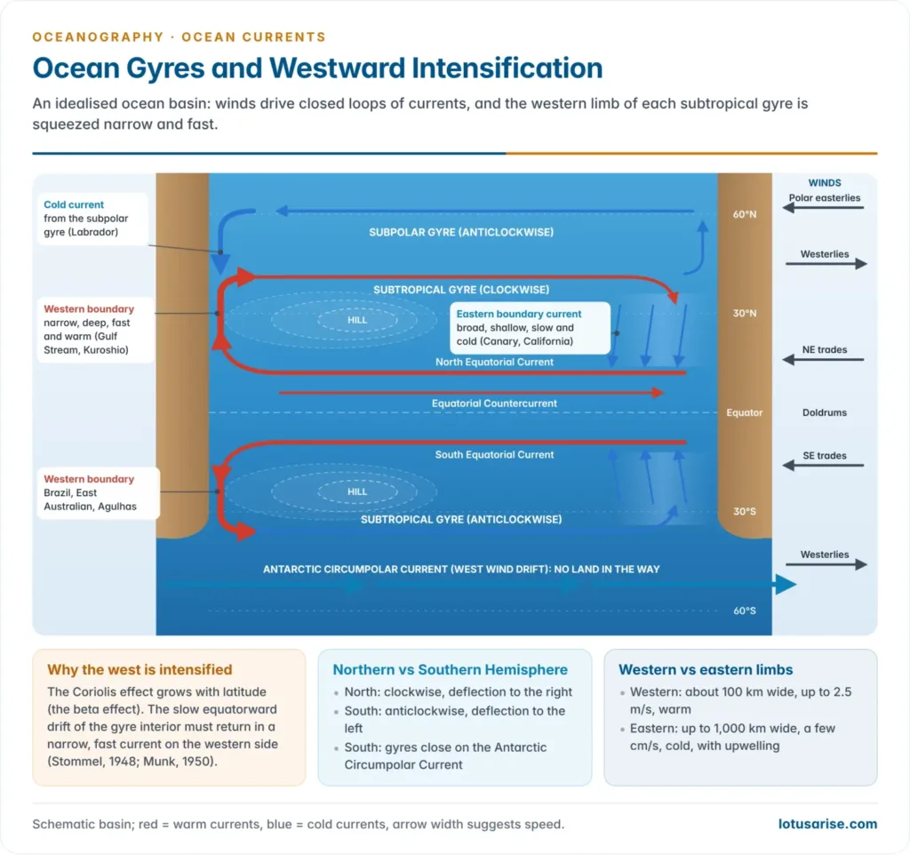
- The currents on the western side of every subtropical gyre are narrow, deep and fast. Those on the eastern side are broad, shallow and slow. Both carry about the same volume, so continuity is kept.
- The Gulf Stream is about 100 km wide, reaches about 1 km deep and flows at up to 2.5 m/s. Its transport grows from about 30 Sv in the Florida Straits to about 150 Sv south of Newfoundland.
- The Canary Current spreads over hundreds of kilometres at a few centimetres per second.
- Cause: Henry Stommel (1948) showed that the intensification comes from the increase of the Coriolis effect with latitude (the beta effect), rather than from rotation alone.
- In the open interior, the wind’s twisting effect pushes water slowly equatorward. This is the Sverdrup balance (1947).
- The return flow can only be squeezed into a narrow western boundary current. Walter Munk (1950) added realistic winds and lateral friction and reproduced a Gulf Stream–like current.
- The summit of the gyre’s hill lies west of centre, so the slope and the geostrophic flow are steepest on the western side.
- Fast western boundary currents meander and pinch off rings. Warm-core rings form on the cold side of the Gulf Stream and spin clockwise; cold-core rings form on the warm side and spin anticlockwise.
| Feature | Western boundary current | Eastern boundary current |
|---|---|---|
| Width | Narrow, under about 100 km | Broad, up to 1,000 km |
| Depth | Deep, about 1–2 km | Shallow, under about 500 m |
| Speed | Fast, up to about 2.5 m/s | Slow, a few cm/s |
| Temperature | Warm | Cool |
| Nutrients and fish | Low in nutrients; poor fishing | Upwelling; rich fishing |
| Examples | Gulf Stream, Kuroshio, Agulhas | Canary, California, Benguela, Peru |
Currents of the individual oceans
- Every basin repeats the gyre plan with local variations: the Gulf Stream and North Atlantic Drift, the Kuroshio–Oyashio meeting, the Humboldt along Peru, and the Agulhas round southern Africa.
- The north Indian Ocean currents are the exception, because they reverse with the monsoon, and the Somali Current becomes one of the fastest currents on Earth in July and August.
Effects of Ocean Currents
Climate and heat transport
- Currents carry heat poleward. With the winds, they move the low-latitude heat surplus to the high-latitude deficit and so help balance the Earth’s heat budget. The ocean’s share is largest in the tropics.
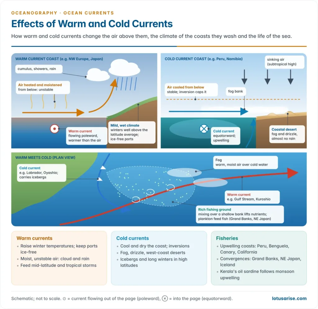
- Warm currents raise winter temperatures well above the average for the latitude.
- The North Atlantic Drift keeps the coast of Norway and the port of Murmansk, north of the Arctic Circle, ice-free in winter. Labrador, at the latitude of Britain but washed by a cold current, is ice-bound for months.
- Air passing over warm water picks up moisture, so warm-current coasts are humid, cloudy and rainy: north-west Europe, south-east USA, Japan and south-east Brazil.
- Cold currents lower temperatures and suppress rain.
- They chill the air from below and create a temperature inversion that blocks the rise of air. Combined with subsiding air under the subtropical high, this produces the west-coast deserts: the Atacama (Peru Current), the Namib (Benguela), the coastal Sahara (Canary) and Baja California (California).
- The Atacama is the driest non-polar desert on Earth. Some coastal stations average only a few millimetres of rain a year.
- Cold currents carry icebergs and sea ice far south, and in high latitudes bring long, snowy winters to the coasts they wash, as the Labrador and Oyashio currents do.
- Changes in currents change climate. When the Peru Current and its upwelling weaken during El Niño, the desert coast of Peru receives heavy rain and the fishery collapses.
Fog, air masses and storms
- Fog forms where warm, moist air crosses cold water, or where warm and cold currents meet. Air is chilled below its dew point to form advection fog.
- The Grand Banks of Newfoundland, where the Gulf Stream meets the Labrador Current, are among the foggiest places at sea. The same happens off Hokkaido and the Kuril Islands, where the Kuroshio meets the Oyashio.
- Cold upwelling gives the summer fogs of San Francisco and the coastal fogs that sustain life in the Namib and Atacama.
- Currents modify air masses that cross them:
- Over a warm current, the air is heated and moistened from below. It becomes unstable, giving cumulus clouds, showers and stronger storms.
- Over a cold current, the air is cooled from below. It becomes stable, with an inversion, low stratus, fog and drizzle but little rain.
- Warm currents feed storms. The heat and moisture of the Gulf Stream and Kuroshio deepen winter mid-latitude cyclones. Warm surface water above about 26–27 °C fuels tropical cyclones, which are rare off cold-current coasts.
Fisheries
- The richest fishing grounds lie where nutrients reach sunlit water. Two settings provide this:
- Convergences of warm and cold currents over shallow shelves, where mixing stirs up nutrients and plankton blooms:
- the Grand Banks (Gulf Stream and Labrador Current);
- the seas north-east of Japan (Kuroshio and Oyashio);
- the waters round Iceland (North Atlantic Drift and East Greenland Current).
- Upwelling coasts, above all Peru, where the anchoveta fishery is among the largest single-species fisheries on Earth. Others are the Benguela, Canary and California systems.
- Convergences of warm and cold currents over shallow shelves, where mixing stirs up nutrients and plankton blooms:
- The Southern Hemisphere has similar meetings of currents but fewer rich grounds, because it has few broad shallow shelves and less land-derived nutrient. The Patagonian Shelf, where the Falkland and Brazil currents meet, is the main exception.
- Currents also distribute life. They carry plankton, larvae and fish eggs, and set the migration routes of tuna and eels.
- India’s fisheries depend on the same processes. Monsoon upwelling off the south-west coast brings the oil sardine and mackerel. Kerala’s oil sardine catch swings with the strength of upwelling and with fishing pressure; it fell to about 3,300 tonnes in 2021, the lowest since 1994.
Navigation and trade
- Sailing ships followed currents and winds. Early routes, such as the trade-wind passage to the Caribbean and the return by the Gulf Stream, were shaped by them. Modern ships still plan routes to ride favourable currents and save fuel.
- Hazards: fog where currents meet, and icebergs carried south by the Labrador Current. The Titanic sank in this iceberg zone south of the Grand Banks in April 1912, and the International Ice Patrol has watched the area since 1914.
- Forecasting: INCOIS issues current forecasts for Indian waters. Its Search and Rescue Aid Tool (SARAT) uses modelled currents and winds to predict where a person or boat lost at sea will drift, for the Coast Guard, the Navy and fishermen.
- Pollution: currents carry oil spills and plastics far from their source and gather floating debris in the gyres.
Currents in a warming ocean
- Atlantification of the Arctic. Warmer, saltier Atlantic water entering through the Barents Sea and Fram Strait has been rising closer to the surface. It melts sea ice from below and weakens the cold, fresh layer that once protected it.
- Work led by Igor Polyakov (2017, 2023) showed this spreading into the Eurasian Basin. It also showed that a shift in winds since 2007 has temporarily slowed the process by strengthening the fresh surface layer.
- The Antarctic Circumpolar Current may slow. A 2025 modelling study projected a slowdown of about 20% by 2050 under high emissions, as meltwater from Antarctica freshens the Southern Ocean.
- The Atlantic Meridional Overturning Circulation is projected to weaken through this century as Greenland melt and warming make North Atlantic surface water lighter. A slower overturning would also slow the northward flow of the Gulf Stream system.
Previous Year Questions
2025What are the fundamental differences among ocean wave, ocean current and tide?2023How are ocean currents generated? Discuss their effects on coastal climates with special reference to the Pacific Ocean.2022What is the relationship between ocean currents and global surface wind systems? Explain with examples how does the gyre in the Northern Hemisphere differ from the one in the Southern Hemisphere.2017Discuss the impacts of ocean currents on air mass behaviour.2016“The relationship between the winds and the currents is best seen in the Indian Ocean.” Justify.2011“Temperature, salinity and density differences in ocean water are the prime causes of ocean water circulation.” Elaborate.2009Comment on marine heat budget and the oceanic circulation system.





Very Summarised, Kudos to the Team.
Thanks Gunjan
by accidentally find this site and now coming here again and again for best material …thanks to the team
Most of the people find this site accidentally 🙂 Keep Learning
I ALSO FOUND ACCIDENTLY AND FEELING LUCKY
Me also accidentally visited the site
Me too same
Me too the same accidental visit
same here
i learned quite a bit after finding this page in my science class. Thanks for all the learnign
It’s very important thing
what a great content! you’ll soon beat all coaching institutes
😊
is these notes contains each and evry topics for upsc
Hello admin, I accidentally found this site and honestly it’s very useful. Please do some advertising or publicity of this content so that more students can be benefitted
Here it’s easy way to understand these ocean currents.. Briefly
By accidentally visited to this
Hi sir why you have left Economy notes? please provide it as soon as u can!
And Thanks a lot sir from the bottom of my heart for your great efforts!❣️
Sure
What the great content! You will beat all coaching institutes so soon!
god bless u sir
Thank you very much for your efforts sir ❤️
How come i discovered this website so late?
Great and crisp content.
Hellow SIr,
Indian, pacific and Atlantic ocean currents are not covered?
based