

- Ocean water is never still. Its movements are grouped by what drives them:
- Waves are oscillations of the surface that carry energy, not water.
- Ocean currents are horizontal streams that carry water itself over thousands of kilometres.
- Tides are the periodic rise and fall of sea level caused by the Moon and the Sun.
- Upwelling and sinking move water vertically, driven by winds and density differences.
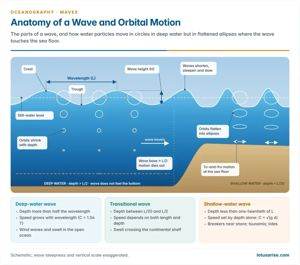
- An ocean wave is a rhythmic undulation of the water surface, produced when energy from a disturbing force, usually wind, passes from particle to particle. Each particle moves in a near-closed orbit and returns almost to its starting point.
- Waves are the ocean’s main agent of coastal erosion and deposition, a chief hazard to shipping and coasts, and a large untapped source of energy.
Nature and Generation of Waves
Kinds of waves in the ocean
- Waves are classed by the disturbing force and the restoring force that pulls the water back to rest. Walter Munk (1950) arranged them in one energy spectrum by period, from ripples lasting under a second to tides lasting a day.
- Most of the ocean’s wave energy lies in wind waves with periods of about 1–30 seconds.
| Type | Disturbing force | Restoring force | Typical period |
|---|---|---|---|
| Capillary waves (ripples) | Light wind | Surface tension | Under 0.1 s |
| Wind waves: sea and swell | Wind | Gravity | 1–30 s |
| Seiches | Wind, pressure change, earthquakes | Gravity | Minutes to hours |
| Tsunamis | Earthquakes, landslides, volcanic eruptions | Gravity | 10 minutes to about an hour |
| Storm surges | Cyclone winds and low pressure | Gravity | Hours |
| Tides | Gravity of the Moon and Sun | Gravity, Coriolis force | About 12 or 24 hours |
| Internal waves | Tides over ridges, currents, storms | Gravity at a density boundary | Minutes to hours |
Parts of a wave
| Term | Meaning |
|---|---|
| Crest and trough | The highest and lowest points of a wave |
| Still-water level | The level the surface would take with no waves |
| Wave height (H) | Vertical distance from trough to crest |
| Amplitude | Half the wave height: the rise of the crest above still-water level |
| Wavelength (L) | Horizontal distance between two successive crests or troughs |
| Wave period (T) | Time for two successive crests to pass a fixed point |
| Frequency | Number of waves passing a point per second (1/T) |
| Wave speed or celerity (C) | Distance the wave form travels per unit time; C = L/T |
| Steepness | Ratio of height to length, H/L |
- Steepness has a limit. A wave breaks when H/L exceeds about 1/7, when its crest has narrowed to about 120°, a limit worked out by John Henry Michell (1893). In the open sea the breaking crests are whitecaps.
Motion of water particles
- Water particles move in orbits, not forward with the wave. A floating bird bobs up and forward under a crest, then down and back under the trough, and ends almost where it began.
- Ocean waves are orbital waves: they combine the to-and-fro motion of longitudinal waves with the up-and-down motion of transverse waves.
- At the surface the orbit diameter equals the wave height.
- Orbits shrink rapidly with depth. At half the wavelength they are only about 4% of the surface size. This depth, L/2, is the wave base; below it even storm waves are not felt.
- The orbits do not quite close. Particles move slightly faster under the crest than under the trough, giving a small net forward drift of water, the Stokes drift, after George Gabriel Stokes (1847).
Deep-water and shallow-water waves
- How a wave behaves depends on the ratio of water depth (d) to wavelength (L):
| Feature | Deep-water wave | Transitional wave | Shallow-water wave |
|---|---|---|---|
| Depth | d > L/2 | L/20 < d < L/2 | d < L/20 |
| Particle orbit | Circles, shrinking to nothing at the wave base | Ellipses | Flat ellipses; to-and-fro motion at the bottom |
| Feels the sea floor? | No | Partly | Yes, through the whole column |
| Speed depends on | Wavelength (or period) only | Both wavelength and depth | Depth only |
| Speed | C = 1.56 T m/s | Between the two | C = √(g d), about 3.1 √d m/s |
| Examples | Wind waves and swell in the open ocean | Swell crossing the outer shelf | Breakers near shore; tsunamis and tides everywhere |
- In deep water, longer waves travel faster. Since L = 1.56 T² metres, a swell of period 10 s is about 156 m long and travels at about 56 km/h.
- In shallow water, speed depends on depth alone. So tsunamis and tides, with wavelengths of hundreds of kilometres, behave as shallow-water waves even over the deepest ocean.
Generation of wind waves
- Wind passes energy to the water by friction and by pressure differences across the uneven surface.
- A light breeze first raises capillary waves: ripples shorter than about 1.7 cm, with rounded crests and V-shaped troughs, restored by surface tension.
- Ripples give the wind a grip. Beyond 1.7 cm, gravity becomes the restoring force and they grow into gravity waves with pointed crests and rounded troughs. Height grows faster than length until whitecaps shed the excess energy.
- How the wind does it has been explained in stages:
- Harold Jeffreys (1925): the sheltering hypothesis, in which air presses on the windward face of a wave and eddies form in its lee.
- Owen Phillips (1957): pressure fluctuations in turbulent wind start waves by resonance.
- John Miles (1957): waves then grow through an instability in the sheared airflow above them. The modern view combines the two.
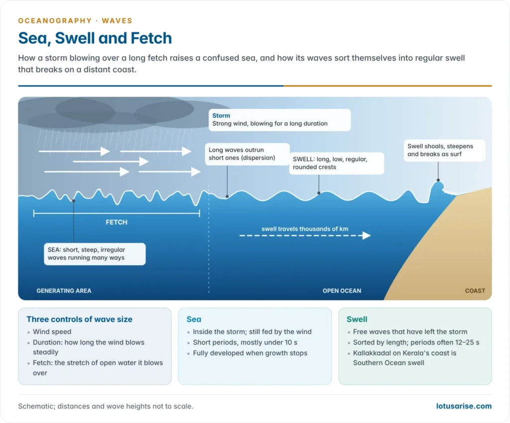
- Three factors set how much energy the waves gain: wind speed, duration (how long it blows steadily) and fetch (the stretch of open water it blows over).
- The fully developed sea. For a given wind speed, waves stop growing once fetch and duration are long enough, because they lose as much energy by breaking as they gain. Stronger winds need far longer fetches and durations:
| Wind speed (km/h) | Fetch needed (km) | Duration needed (hours) |
|---|---|---|
| 20 | 24 | 2.75 |
| 40 | 176 | 11.5 |
| 60 | 660 | 27.5 |
| 80 | 1,682 | 50 |
| 90 | 2,446 | 65 |
- The Southern Ocean has the highest average waves on Earth, because the westerlies of the Roaring Forties, Furious Fifties and Screaming Sixties blow over an almost unbroken fetch.
- On India’s west coast, the south-west monsoon raises high, steep waves from June to September, when beaches erode and fishing is restricted.
- The Beaufort scale of Francis Beaufort (1805) describes sea state from 0 (calm, mirror-like) through 6 (large waves, whitecaps everywhere) to 12 (hurricane, sea white with spray).
Sea and swell
- Sea is the confused surface inside the generating area: short, steep, irregular waves running in many directions.
- Swell forms as waves leave the storm:
- Long waves travel faster than short ones, so the waves sort themselves by wavelength (dispersion). Short waves lag and die out.
- What remains is long-crested, regular, low and rounded, with long periods, often 12–25 s.
- Swell loses little energy and can cross whole oceans. Swell from Southern Ocean storms has been traced to Alaska, more than 10,000 km away.
- It travels as wave trains. In deep water a group moves at half the speed of its individual waves, which appear at its back and die out at its front.
- From a swell’s period and arrival time, forecasters can locate the distant storm that raised it.
- Interference. Where swells meet, heights add (constructive) or cancel (destructive). Most meetings are mixed, so sets of large waves arrive between smaller ones (surf beat).
- Significant wave height (Hs), the average height of the highest third of the waves, is the figure used in forecasts.
| Feature | Sea | Swell |
|---|---|---|
| Where | Inside the wind area | Outside it, often thousands of km away |
| Form | Short, steep, irregular, peaked crests | Long, low, regular, rounded crests |
| Period | Short (mostly under 10 s) | Long (often 12–25 s) |
| Direction | Many directions at once | One dominant direction |
| Energy supply | Still being fed by the wind | Free waves, slowly losing energy |
Waves of oscillation and waves of translation
- In a wave of oscillation, the form moves forward but the water does not; particles trace closed orbits. All wind waves and swell in deep water are of this kind.
- In a wave of translation, the water itself moves forward with the wave.
- It forms where a breaking crest topples forward and throws a mass of water ahead, so the shoreward rush of broken waves is a wave of translation.
- The ideal case is the solitary wave, a single hump with a crest and no trough, first described by John Scott Russell (1834), who followed one along a Scottish canal.
- Such waves carry sand and shingle landward and build beaches. They matter little at sea but dominate on gently shelving coasts.
| Feature | Wave of oscillation | Wave of translation |
|---|---|---|
| Movement of water | Particles move in orbits and return to their place | Water is carried forward with the wave |
| Form | Crest and trough | Crest only (solitary hump) or a broken bore |
| Where | Open ocean, deep water | Surf zone, after breaking; shallow coasts |
| Energy | Transmitted with little loss | Spent in moving water and sediment |
| Work | Little; can stir the bed near the wave base | Transports sediment, runs up the beach as swash |
| Examples | Wind waves and swell at sea | Swash, surf bores, solitary waves |
Waves at the Coast
Shoaling and breaking
- Shoaling. In water shallower than half its wavelength, a wave touches bottom.
- Its speed and wavelength fall while its period stays the same, so the energy is squeezed into a shorter wave and its height increases.
- Crests become narrow and pointed, troughs wide and flat, and orbits flatten into ellipses.
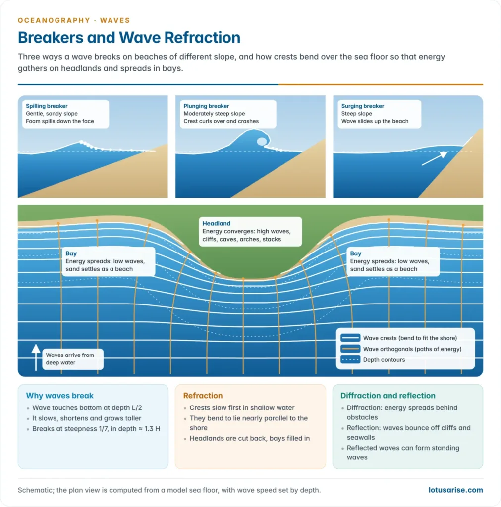
- Breaking. The crest, moving faster than the slowed base, outruns its support and topples. A wave breaks when its steepness passes about 1/7, in water roughly 1.3 times its own height deep.
- Surf is the zone of breaking waves. The broken water rushes up the beach as swash and drains back by gravity as backwash.
- Distant swell gives regular lines of breakers; local storm waves break farther out as rough, irregular surf.
- The calema of the Gulf of Guinea, raised by South Atlantic swell, long made landing difficult on that harbourless coast.
- Surf-zone currents: longshore currents run along the beach where waves arrive at an angle and drive longshore drift; rip currents are narrow seaward jets that return the piled-up water and are the main danger to swimmers.
Types of breakers
| Breaker | Beach slope | Deep-water steepness of the wave | How it breaks |
|---|---|---|---|
| Spilling | Gentle, flat, sandy | Steep | Crest spills down the front as foam over a wide surf zone; energy lost gradually |
| Plunging | Moderately steep | Moderate, long swell | Crest curls over an air pocket and crashes into the trough; sudden energy release |
| Surging | Steep | Low, long | Wave does not break fully; it slides up the beach as a rising wall of water |
| Collapsing | Steep | Low | Between plunging and surging; the face collapses just before the shore |
Constructive and destructive waves
| Feature | Constructive waves | Destructive waves |
|---|---|---|
| Source | Long swell from distant storms | Local storms and onshore gales |
| Form | Low, long, gentle; 6–8 per minute | High, short, steep; 10–14 per minute |
| Breaker | Spilling | Plunging |
| Swash and backwash | Strong swash, weak backwash | Weak swash, strong backwash |
| Result | Sand pushed up; beach built up and steepened | Material dragged seaward; beach cut back and flattened |
| Season (Indian west coast) | Fair-weather months | South-west monsoon |
Refraction, diffraction and reflection
- Wave refraction is the bending of wave crests in shallow water, because the part of a crest in shallower water slows first. Crests swing round to become nearly parallel to the shore.
- At a headland the floor shoals sooner, so crests bend towards it from both sides. Wave energy converges there, waves are high and erosion is intense.
- In a bay crests spread apart, energy diverges, waves are low and sediment settles.
- Headlands are cut back and bays filled, so refraction straightens an irregular coast.
- Wave diffraction is the sideways spreading of wave energy along a crest into sheltered water behind a breakwater, island or harbour mouth, so smaller waves reach water the obstacle seems to shield.
- Wave reflection occurs where waves strike a steep cliff, seawall or breakwater and bounce back with little energy loss.
- Reflected and incoming waves of the same length form standing waves (clapotis), with nodes where the surface stays level and antinodes where crest and trough alternate in place.
- Reflection off vertical seawalls scours the beach in front of them, as on armoured stretches of the Kerala and Puducherry coasts.
Work of waves
- Erosion works by hydraulic action (water and compressed air forced into joints), abrasion (sand and shingle hurled at rock), attrition and solution.
- Waves undercut cliffs, leaving a wave-cut notch and platform, and carve caves, arches and stacks at headlands.
- Deposition builds beaches, spits, bars and tombolos where wave energy is low or sediment is plentiful.
- Wave energy can be harnessed. India’s first wave-power plant, a 150 kW oscillating water column, was built by IIT Madras at Vizhinjam, Kerala (1991). Wave power remains experimental in India, as waves are moderate outside the monsoon.
Special Waves and Wave Hazards
Internal waves
- Internal waves travel along a density boundary inside the ocean, usually the pycnocline between light surface water and dense water below.
- The density difference is tiny, so the restoring force is weak. They are slow, with periods of minutes to hours, and much taller than surface waves, often tens of metres and sometimes over 100 m.
- The largest known, about 170 m high, are raised by tides flowing over ridges in the Luzon Strait and cross the South China Sea. Those of the Andaman Sea show from space as bands of rough and smooth water.
- They mix heat and nutrients across the thermocline and can jolt submarines and offshore rigs.
Seiches
- A seiche is a standing wave in an enclosed or partly enclosed basin: a lake, bay, harbour or gulf. The whole surface sloshes back and forth like water in a rocked tray.
- It is set off by winds piling water at one end, a sudden change in air pressure, an earthquake, a tsunami or a landslide.
- Water rises and falls at the ends about a nodal line where the level does not change.
- The period depends on basin length and depth (Merian’s formula: period = 2 × length ÷ √(g × depth)), from minutes in harbours to hours in large lakes.
- The term comes from Lake Geneva, where François-Alphonse Forel studied them from the 1870s. Harbour seiches can snap mooring lines; lake seiches flood shores without warning.
- In September 2023 a rockslide into Dickson Fjord, East Greenland, raised a tsunami about 200 m high that settled into a seiche about 7 m high, sloshing every 92 seconds for nine days and recorded by seismometers worldwide.
Storm surges
- A storm surge is an abnormal rise of sea level above the predicted tide, caused by a tropical cyclone or severe storm. Surge plus tide is the storm tide.
- Causes:
- Wind set-up: strong onshore winds drive water against the coast. This is the larger part.
- Low pressure: the sea rises about 1 cm for every hectopascal fall in pressure (the inverse barometer effect).
- Wave set-up: breaking waves raise the mean water level near shore.
- Surges are highest where the shelf is broad and shallow, the coast is funnel-shaped, and an intense, slow cyclone crosses at right angles at high spring tide.
- The head of the Bay of Bengal has all these conditions and is the world’s most surge-prone coast.
- The Bhola cyclone (1970) drowned an estimated 300,000–500,000 people in present-day Bangladesh, the deadliest cyclone on record.
- The Odisha, Sundarbans and Andhra delta coasts are India’s most exposed, as the Odisha super cyclone (1999) showed. IMD now issues storm-surge guidance with every cyclone warning, and warnings with evacuation have sharply cut deaths since.
| Feature | Storm surge | Seiche |
|---|---|---|
| Nature | Progressive rise of sea level that moves ashore with the storm | Standing wave oscillating in an enclosed basin |
| Cause | Cyclone winds and low pressure | Wind, pressure jumps, earthquakes, landslides |
| Setting | Open coasts with broad shelves | Lakes, bays, harbours, fjords |
| Duration | A few hours, one main rise | Repeated oscillations for hours or days |
| Period | Not periodic | Set by basin length and depth |
| Example | Bay of Bengal, 1970; Odisha, 1999 | Lake Geneva; Lake Erie; Dickson Fjord, 2023 |
Rogue waves
- A rogue (freak) wave is a single wave more than twice the significant wave height of the sea around it. It appears without warning, often as a steep wall of water ahead of a deep trough.
- Causes: constructive interference of waves of different lengths and directions; wave–current interaction, as where Southern Ocean swell meets the Agulhas Current off south-east Africa; and non-linear focusing, where one wave draws energy from its neighbours.
- Measured cases:
- The Draupner wave (1 January 1995), about 25.6 m high in a sea of about 12 m significant height, struck a North Sea gas platform. It was the first rogue wave measured by instruments.
- A wave of about 34 m was measured from the US Navy tanker Ramapo in the North Pacific on 7 February 1933, the largest wind wave reliably observed at sea.
- The highest significant wave height recorded by a buoy, 19 m, was measured between Iceland and the UK on 4 February 2013, as certified by the World Meteorological Organization.
- Splash waves from landslides are taller still. A rockfall into Lituya Bay, Alaska (9 July 1958) sent water 524 m up the opposite slope, the highest wave run-up on record.
Tsunamis
- A tsunami is a series of waves raised when a large volume of water is suddenly displaced, mostly by vertical sea-floor movement in a submarine earthquake, and also by landslides, eruptions or impacts. It has nothing to do with tides.
- Its wavelength is 100–200 km, so it is a shallow-water wave even in the deep ocean. Over 4,000 m of water it travels at about 700 km/h, yet is usually under 1 m high and passes ships unnoticed.
- Near land it slows and piles up into a fast-rising flood many metres high, often after the sea first draws back.
- The Indian Ocean tsunami (26 December 2004), from a magnitude 9.1 earthquake off Sumatra, killed about 230,000 people in 14 countries, over 10,000 of them in India. It led to the Indian Tsunami Early Warning Centre at INCOIS, Hyderabad (2007), which also serves other Indian Ocean rim countries.
- The magnitude 8.8 Kamchatka earthquake of 30 July 2025 set off Pacific-wide warnings; most coasts saw waves of a metre or less.
Swell surges (kallakkadal) on India’s coast
- Kallakkadal (Malayalam: “thief sea”) is the fishers’ name for sudden coastal flooding by long-period swell on calm, clear days, with no local storm or warning sign. The term is now used in science.
- The swell is raised by intense storms in the Southern Ocean and South Atlantic, south of about 30°S, often around 10,000 km away, and takes five to six days to reach India’s southern tip.
- It shoals and surges over beaches and seawalls, mostly on the Kerala and southern Tamil Nadu coasts, chiefly in the pre-monsoon months.
- The 2024 events. Swell surges flooded houses on the Kerala and Kanniyakumari coasts on 31 March 2024 and again in April. For 4–5 May 2024 INCOIS issued the first-ever red alert for a swell surge in Kerala, for swell from a South Atlantic storm with periods of about 24 s.
- These warnings come from the INCOIS Swell Surge Forecast System (2020).
Forecasting and monitoring waves
- INCOIS runs India’s Ocean State Forecast of wave height, period and direction, swell, winds and currents, several days ahead, from numerical wave models.
- High wave alerts and swell-surge warnings go to coastal states and fishers. The Small Vessel Advisory and Forecast Services System (2020) warns small boats of zones where they risk capsizing.
- Wave-rider buoys, moored buoys and satellite altimeters, such as the Indo-French SARAL-AltiKa (2013), measure wave height and feed the models.
- Waves are changing. Satellite and buoy records for 1985–2018 show extreme wave heights in the Southern Ocean rising by about 30 cm (about 5%) as the westerlies strengthened, sending more energetic swell to distant coasts such as India’s.
Waves, Currents and Tides Compared
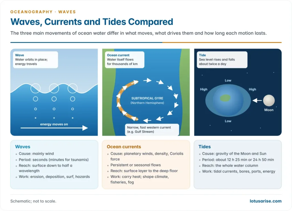
| Basis | Waves | Ocean currents | Tides |
|---|---|---|---|
| Nature | Oscillation of the surface | Steady horizontal flow of water | Periodic rise and fall of sea level |
| What moves | Energy; water only orbits | Water itself, over long distances | Sea level; tidal currents flow in and out |
| Main cause | Wind (also earthquakes, landslides) | Planetary winds, density differences, Coriolis force | Gravity of the Moon and Sun, Earth’s rotation |
| Time scale | Seconds (wind waves) to minutes (tsunamis) | Persistent or seasonal | About 12 h 25 min or 24 h 50 min cycles |
| Depth affected | Surface layer down to half a wavelength | Surface currents to about 1 km; deep currents to the floor | Whole water column |
| Spatial scale | Metres to hundreds of kilometres | Ocean-basin gyres | Planetary bulges; local range set by coast shape |
| Effects | Coastal erosion and deposition, surf, hazards | Climate, fisheries, fog, navigation | Navigation, tidal bores, ports, tidal energy |
| Examples | Monsoon waves on the Kerala coast; 2004 tsunami | Gulf Stream; Somali Current | Gulf of Khambhat’s large range; Hooghly bore |





Awesome explaination
Sir, its a really commendable job that you are using…I really appreciate it..I want to extend my heartiest support to you… But ,I don’t have money to join coaching classes also… Once again thank you…and sorry…
But when ever I am capable ,I will really contribute to your hard work 🙏🙏🙏🙏
Also Sir,the pending topics explaination will be coming until when??? Pls update on this..
Very Soon!
Cant thankyou enough for these beautiful notes….Very well explained….All of my doubts are answered here.
You guys are the best!
Rise and Shine Lotus arise Team.
We love you!
We will make you feel proud.
Definitely I will contribute you soon sir! Iam really weak particularly in geography and mains due to lack of notes supplement but you make a hope to me sir …thank you sir …hard work never in vain sir …definitely you get a good fame in upsc websites at soon sir
I am extremly thankfull to you for providing us such amazing content explained with such simple wordings. before i was worried about the content than universes landed me into this website.
“You’re very welcome. It’s a pleasure.” Keep Reading
Doesnt the strength of the current , increase the wave hight …does orbital velocity or intensity increase wave height
thnq so much sir
Thank you so much sir for such an excellent content!🙏❤️