

- Tides are the rhythmic, periodic rise and fall of sea level, normally twice a day, produced by the gravitational pull of the Moon and the Sun on a rotating Earth.
- The rise with its landward flow is the flood; the fall with its seaward flow is the ebb.
- A tide is a wave of enormous length: its crest is the high tide and its trough the low tide, and one wavelength spans half the globe. Even in the deepest ocean it behaves as a shallow-water wave, whose speed depends only on depth.
- Unlike wind waves, tides move the whole water column from surface to sea floor. They are the most regular and predictable of all movements of the sea, because they follow the known motions of the Earth, Moon and Sun.
- Three kinds of motion compared: wind waves have periods of seconds and stir only the surface layer; ocean currents are steady, one-way flows driven by winds and density; tides are astronomical, with periods of about 12 or 24 hours.
Tide-Producing Forces
Basic terms
| Term | Meaning |
|---|---|
| High water (high tide) | Highest level reached in one tidal cycle |
| Low water (low tide) | Lowest level reached in one tidal cycle |
| Tidal range | Vertical difference between a high water and the next low water |
| Flood and ebb | Rising tide with landward flow; falling tide with seaward flow |
| Slack water | Brief spell of weak or no tidal current when the flow turns |
| Tidal interval | Time between two successive high waters, about 12 h 25 min |
| Tidal (lunar) day | Time between two successive passages of the Moon over a meridian, about 24 h 50 min |
| Intertidal zone | Shore strip covered at high water and exposed at low water |
- Stages of a tide: the sea rises for about six hours and floods the intertidal zone (flood), stands briefly at high water, falls for about six hours and exposes the shore (ebb), and stands again at low water.
Gravity and the tide-generating force
- The link between the Moon and the tides was noticed in antiquity; Pytheas of Massalia related them around 330 BCE. Isaac Newton explained it in the Principia (1687) through his law of universal gravitation.
- Gravitational attraction is proportional to the product of the masses and inversely proportional to the square of the distance between their centres.
- The tide-generating force is not gravity itself but the difference in the pull across the Earth’s diameter. It therefore varies with the inverse cube of the distance, so distance matters even more than mass.
- Why the Moon dominates: the Sun is about 27 million times as massive as the Moon but about 390 times as far away.
- 27 million ÷ 390³ gives about 0.46, so the Sun’s tide-raising force is about 46% of the Moon’s. Lunar tides are a little more than twice as strong as solar tides.
- The force is tiny, about one ten-millionth of the Earth’s gravity.
- Its vertical component only slightly lightens or adds to gravity and moves little water.
- Its horizontal (tractive) component drags water across the surface towards two points, and this is what piles up the bulges.
The Earth–Moon system and the two bulges
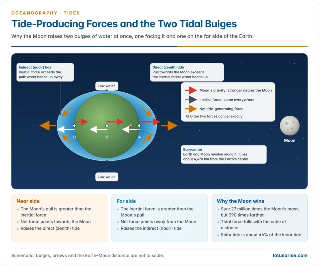
- The Earth and Moon revolve around a common centre of mass, the barycentre.
- The Earth is about 81 times as massive as the Moon, so the barycentre lies inside the Earth, about 4,670 km from its centre, or roughly 1,700 km below the surface on the side facing the Moon.
- Every point of the Earth moves in a circle of the same radius about the barycentre, so the inertial (centrifugal) force of this revolution is equal in size and direction everywhere and points away from the Moon.
- The Moon’s gravity is not uniform. It is strongest on the side facing the Moon and weakest on the far side.
- At the Earth’s centre the two forces exactly balance, which keeps the Earth and Moon in orbit.
- Near side: gravity exceeds the inertial force. The net force pulls water towards the Moon and raises the direct (zenith) tide.
- Far side: the inertial force exceeds gravity. The net force pushes water away from the Moon and raises the indirect (nadir) tide.
- Between them, on the circle 90° from the line joining Earth and Moon, water is drawn off towards the bulges and low water results.
- The Sun raises its own pair of solar bulges in the same way, about half as high.
Timing of tides
- The Earth turns beneath the two bulges, so most places get two high and two low waters in each turn.
- The tides are about 50 minutes later each day. The Moon orbits eastward, about 12.2° a day (360° ÷ 29.53 days), so after one rotation of 24 hours the Earth must turn for about another 50 minutes to bring a place back under the Moon.
- The tidal day is therefore about 24 h 50 min, high waters come about 12 h 25 min apart, and high and low water are a little over six hours apart.
- Declination and the diurnal inequality: the Moon’s orbit is tilted about 5° to the ecliptic, so the Moon swings up to about 28.5° north and south of the equator each month.
- The 18.6-year cycle of the Moon’s orbit varies this maximum declination between about 18.5° and 28.5°.
- When the Moon stands well north or south, the two bulges sit off-centre. A place away from the equator then passes through a thick part of one bulge and a thin part of the other, so its two daily high waters differ in height. This is the diurnal inequality.
- Tides at maximum declination, when the inequality is greatest, are tropic tides. Tides with the Moon over the equator, when the two daily tides are nearly equal, are equatorial tides.
Rhythms and Types of Tides
Spring and neap tides
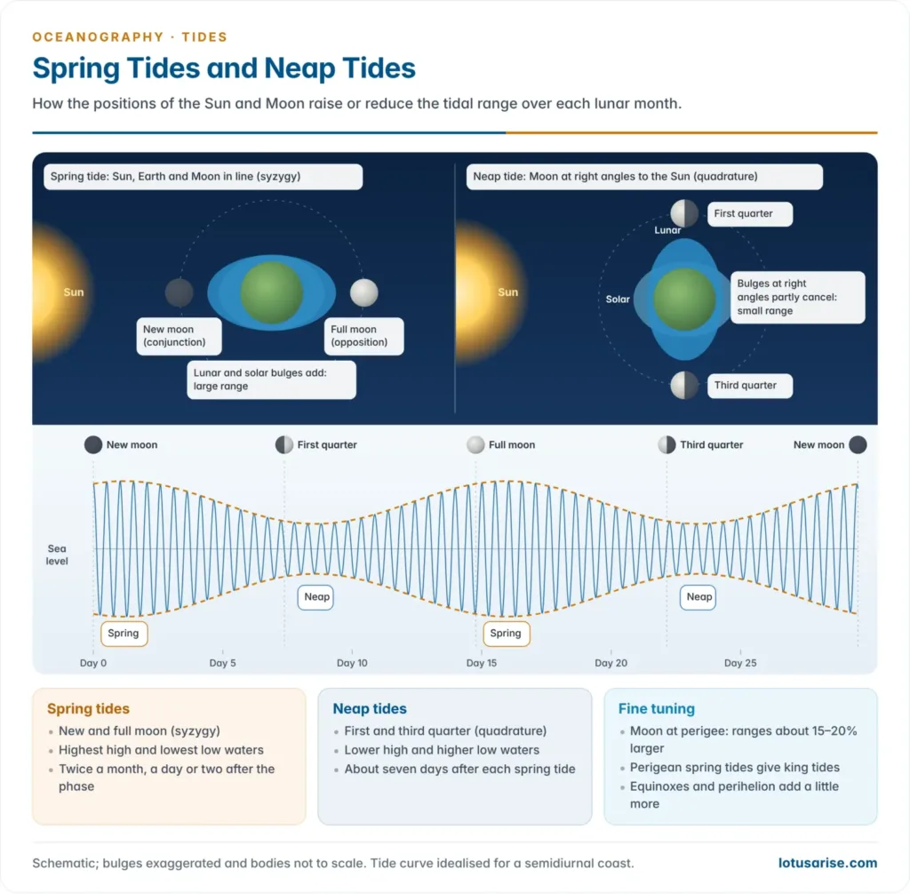
- Spring tides have the largest range: higher high waters and lower low waters. They occur when the Sun, Earth and Moon lie in a straight line (syzygy), so the solar and lunar bulges add together.
- Conjunction: the Moon lies between the Earth and the Sun at new moon (amavasya).
- Opposition: the Earth lies between the Sun and the Moon at full moon (purnima).
- Spring tides come twice a lunar month, about every 14.8 days, and are commonly about 20% above the mean range. “Spring” means a welling up of water, not the season.
- Neap tides have the smallest range. At the first and third quarter moons the Moon stands at right angles to the Sun (quadrature), so the solar bulge falls in the lunar trough and partly cancels it.
- They also come twice a month, about seven days after each spring tide, and are commonly about 20% below the mean range.
- Age of the tide: the largest tides usually arrive a day or two after new and full moon, not on the day itself, because the ocean takes time to respond to the forcing.
Perigean and apogean tides
- The Moon’s orbit is an ellipse. Its distance swings between perigee, about 356,500–370,000 km, and apogee, about 404,000–406,700 km, over the 27.55-day anomalistic month.
- Because the force varies with the cube of the distance, perigean tides have ranges roughly 15–20% above average, and apogean tides fall about as far below it.
- Perigean spring tides come when perigee coincides with new or full moon (a “supermoon”). They give the year’s highest high waters, often called king tides, and lead to high-tide flooding on low coasts, especially when a storm adds a surge.
- Apogean neap tides give the smallest ranges of all.
Perihelion, aphelion and equinoctial tides
- The Earth is nearest the Sun at perihelion (about 3 January) and farthest at aphelion (about 4 July). The solar tidal force is about 10% stronger at perihelion, so ranges are slightly larger in the northern winter.
- Equinoctial spring tides: near the March and September equinoxes the Sun is over the equator. Spring tides then have small diurnal inequality and rank among the year’s largest.
- Solstitial tides: near the solstices the Sun’s declination is greatest and diurnal inequality increases.
- Long cycles: the 18.6-year lunar nodal cycle slightly raises and lowers tidal ranges over the decades. A NASA–University of Hawaii study (2021) projected that, combined with sea-level rise, it would bring a sharp jump in high-tide flooding on US coasts in the mid-2030s.
| Configuration | Cause | Effect on range | Frequency |
|---|---|---|---|
| Spring tide | Syzygy (new and full moon) | Largest | Twice a month |
| Neap tide | Quadrature (quarter moons) | Smallest | Twice a month |
| Perigean tide | Moon nearest the Earth | About 15–20% larger | Once a month |
| Apogean tide | Moon farthest from the Earth | About 15–20% smaller | Once a month |
| Tropic tide | Moon at greatest declination | Large diurnal inequality | Twice a month |
| Equatorial tide | Moon over the equator | Little diurnal inequality | Twice a month |
| Equinoctial spring tide | Sun over the equator at spring tide | Among the year’s largest | March and September |
Diurnal, semidiurnal and mixed tides
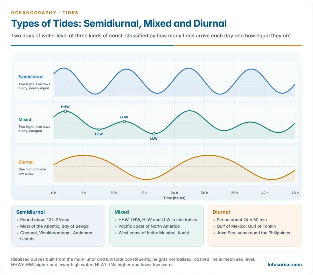
- How many tides a place gets each day depends on how its ocean basin responds to the forcing, and so varies from one coast to another.
- Semidiurnal tide: two high and two low waters each tidal day, with nearly equal heights. It is the most common type.
- Examples: the Atlantic coasts of Europe and North America, West Africa and much of the Bay of Bengal, including Chennai, Visakhapatnam and the Andaman Islands.
- Diurnal tide: one high and one low water each tidal day.
- Examples: the Gulf of Mexico, parts of South-East Asia such as the Gulf of Tonkin and Java Sea, the seas round the Philippines, and parts of the Alaskan coast.
- Mixed tide: two high and two low waters a day of markedly unequal heights. A tide table lists them as higher high water, lower high water, higher low water and lower low water.
- Examples: the Pacific coast of North America, many Pacific islands, and much of the Indian Ocean, including the west coast of India. Mumbai and Kochi have mixed, mainly semidiurnal tides.
- Harmonic constituents: each type is a blend of partial tides.
- The main ones are the principal lunar semidiurnal M2 (12.42 h), the principal solar semidiurnal S2 (12.00 h), and the lunisolar diurnal K1 (23.93 h) and principal lunar diurnal O1 (25.82 h).
- The form factor, F = (K1 + O1) ÷ (M2 + S2), classifies a tide: below 0.25 semidiurnal; 0.25–1.5 mixed, mainly semidiurnal; 1.5–3 mixed, mainly diurnal; above 3 diurnal.
- Local anomalies arise from shallow water and coastal shape:
- Southampton has a double high water. A second high follows about two hours after the first, so high water stands for over three hours. The shallow Solent distorts the tide and adds short-period overtides to it.
- Portland, on the Dorset coast, has a double low water.
- Prediction: William Thomson (Lord Kelvin) introduced harmonic analysis of tides in the 1860s and built a mechanical tide-predicting machine in the 1870s. Arthur Thomas Doodson (1921) set out the tide-generating potential as several hundred harmonic constituents.
- Reliable constants need records spanning the 18.6-year nodal cycle. In India the Survey of India publishes the annual Indian Tide Tables.
| Type | High waters a day | Heights | Typical coasts |
|---|---|---|---|
| Semidiurnal | 2 | Nearly equal | North Atlantic coasts; Bay of Bengal |
| Mixed | 2 | Markedly unequal | Pacific North America; west coast of India |
| Diurnal | 1 | — | Gulf of Mexico; Gulf of Tonkin; Java Sea |
Theories of Tides
- Working out the forces is an astronomical problem with an exact answer. Working out the ocean’s response to them, which gives the actual time and height of the tide at each coast, is a hydrodynamic problem. The theories below are successive attempts to solve it.
Equilibrium theory
- Proposed by Isaac Newton (1687); Daniel Bernoulli later worked out its static form.
- Assumptions: the Earth is wholly covered by a deep ocean of uniform depth, with no continents and no friction, and the water adjusts instantly to the tide-producing forces.
- Mechanism: water heaps up into two bulges, one under the Moon and one opposite, with low water midway. As the Earth turns, each meridian passes under both bulges, giving two high and two low waters each lunar day. The Sun adds a smaller pair.
- The calculated equilibrium range is only about 54 cm for the lunar tide and about 25 cm for the solar tide.
- Merits:
- It identifies the tide-producing forces correctly.
- It explains the periodicities: the semidiurnal rhythm, the 50-minute daily lag, spring and neap tides, perigean and apogean tides, and the diurnal inequality caused by declination.
- It remains the starting point for tide prediction and for every later theory.
- Criticisms:
- The ocean is not continuous. Continents running north–south block the free travel of the bulges.
- The ocean is too shallow to keep up. A tide wave travels at √(gd), about 200 m/s or 700 km/h in water 4 km deep. To keep pace with the Moon at the equator, about 1,600 km/h, the ocean would need to be about 22 km deep. The bulges can never take up their equilibrium positions.
- High water does not occur when the Moon crosses the meridian, as the theory predicts. It arrives hours earlier or later, and the lag differs from place to place.
- Places on the same meridian have tides at different times. Liverpool and Leith, on almost the same longitude, have high water at quite different times.
- It cannot explain real ranges, from almost nothing in the Mediterranean to about 16 m in the Bay of Fundy, nor why some coasts have diurnal tides.
- It ignores friction, the Coriolis force, depth and bottom relief, and the natural oscillations of each ocean basin.
Dynamic theory
- Put forward by Pierre-Simon Laplace (1775). In 1776 he wrote the Laplace tidal equations, which describe how a rotating, fluid ocean actually moves under the tide-producing forces.
- Key ideas:
- Only the horizontal (tractive) components of the force matter for moving water.
- The ocean responds as a forced oscillation. Its response depends on depth, on the Earth’s rotation, and on how near each basin’s natural period lies to the period of the forcing.
- Every partial tide of the tide-generating potential sets up an oscillation of the same period in the ocean. This is why harmonic prediction works.
- What it explains: why tides lag behind the Moon; why ranges differ so much; why the diurnal tide is weak on the Atlantic coast of Europe, as at Brest, while it is strong in parts of the Pacific and Indian Oceans; and why low water, not high water, can occur under the Moon.
- Limitations: Laplace could solve his equations only for idealised ocean basins of simple shape. The real ocean, with its coasts and relief, was beyond hand calculation.
- Later work by Henri Poincaré, Robert von Sterneck, Albert Defant, Joseph Proudman and Walter Hansen extended the theory. Today the equations are solved by computer and checked against satellite altimetry.
- Modern tidal science is the dynamic theory, solved numerically for the real ocean.
Progressive wave theory
- Advanced by William Whewell (1833) from observations rather than calculation. At his urging, tide readings were taken at hundreds of stations on both sides of the Atlantic in June 1835, and he drew the first map of co-tidal lines.
- Mechanism:
- The Southern Ocean is the only belt of unbroken water round the globe. There the tide-producing forces raise two primary tidal waves that travel east to west, following the Moon.
- As they pass the mouths of the Atlantic, Pacific and Indian Oceans, they send secondary (derived) waves northward into each ocean. These branch again into the marginal seas and gulfs.
- The crest of a wave arriving at a coast gives high water and the trough low water. The wave travels at √(gd), faster in deep mid-ocean water than near the shore, so the co-tidal lines bow northward in the middle of the Atlantic.
- The age of the tide, the delay after the Moon’s transit, should increase northward as the waves travel farther.
- George Biddell Airy developed the related canal theory in Tides and Waves (1842). It treats tides as waves in channels of given depth and width, with friction.
- Criticisms:
- Spring tides arrive at almost the same time at Cape Horn and Cape Farewell in Greenland. A wave travelling north would reach Greenland many hours later.
- The theory cannot explain why the type of tide changes from place to place, such as the strong diurnal inequality off California or the tide at Tahiti, which stays nearly fixed at midday and midnight and follows the Sun.
- The branch waves lose too much energy to raise the large tides of the North Atlantic.
- Whewell himself later withdrew his pure progressive-wave map under the influence of Airy’s work. Tides are now seen as regional responses of each basin, not a single wave born in the south.
Stationary wave theory
- Proposed by Rollin Arthur Harris of the US Coast and Geodetic Survey in the early 1900s. He treated tides as standing oscillations in natural basins.
- The analogy of a tilted tray: if a tray of water is tilted and set down, the water rocks to and fro, rising at one end while it falls at the other, but does not travel.
- The nodal line across the middle shows no change of level. Range is greatest at the ends.
- A basin may rock about one nodal line, a uninodal system, or about two, a binodal system with high water in the middle while both ends are low.
- Natural period: a closed basin oscillates with a period T = 2L ÷ √(gh), where L is its length and h its depth (Merian’s formula). A bay open at one end has a period of about 4L ÷ √(gh).
- Core idea: resonance. Each ocean is divided into oscillating areas. Where an area’s natural period is close to the period of a tide-producing force, it resonates and gives large tides.
- Places near a nodal line have small ranges; places far from it have large ones.
- The Bay of Fundy and Gulf of Maine have a natural period of about 13 hours, close to the 12.42-hour lunar semidiurnal period. This near-resonance helps explain the world’s largest tides at the head of the bay.
- The Red Sea, a long, narrow and deep basin, behaves almost exactly as a standing wave predicts. Range is very small near its middle, between Port Sudan and Jeddah, and larger at both ends.
- Merits: it explains local differences in range, type and timing and treats tides as regional, not global, phenomena.
- Criticisms:
- It assumed neighbouring oscillating areas do not interact, which is wrong.
- In its simple form it ignored the Earth’s rotation. Its emphasis on resonance was nonetheless a major advance, and it led directly to the modern amphidromic picture.
Amphidromic systems: the modern synthesis
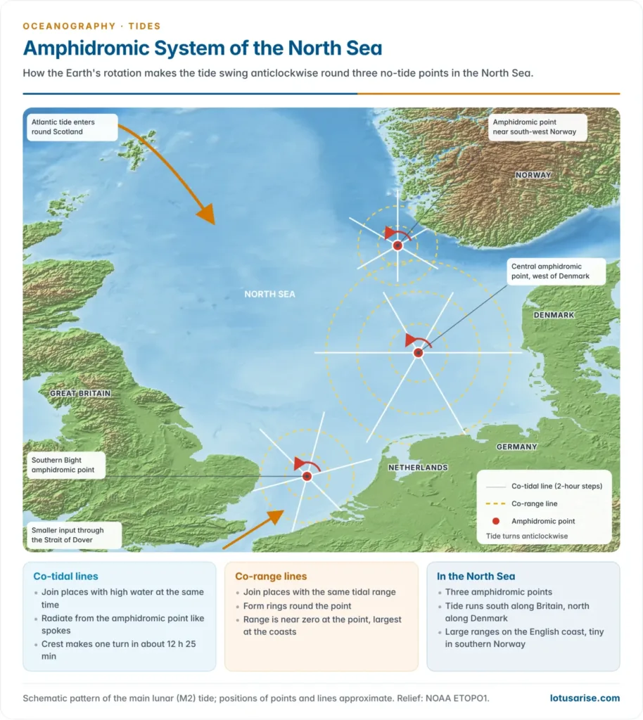
- In a basin as large as an ocean, the Coriolis force turns a standing oscillation into a tide that rotates around a point. The tidal crest sweeps round the basin as a Kelvin wave, hugging the coast on its right in the Northern Hemisphere.
- Amphidromic point: a point of zero or near-zero tidal range at the centre of the rotation. The name comes from Greek amphi, around, and dromos, running.
- Co-tidal lines join places where high water occurs at the same time. They radiate from the amphidromic point like the spokes of a wheel, one line for each hour of the tide.
- Co-range lines join places of equal tidal range. They form roughly concentric rings round the point, and range increases outward to the coasts.
- The crest makes one full turn each tidal period, about 12 h 25 min for the main lunar tide.
- Rotation is anticlockwise in the Northern Hemisphere and clockwise in the Southern Hemisphere, though local exceptions occur.
- The North Sea is the classic example. Whewell inferred a no-tide point there from his co-tidal lines in the 1830s. It has three amphidromic points:
- one in the Southern Bight between East Anglia and the Netherlands;
- one in the central North Sea west of Denmark;
- one close to south-western Norway.
- The tide enters from the Atlantic round Scotland and runs south down the British coast, where ranges reach several metres. It then turns east and north along the Dutch, German and Danish coasts.
- Range is smallest near the amphidromic points, which is why the southern coast of Norway has very small tides.
- Other examples: an amphidromic point in the North Channel of the Irish Sea, and the several points in the North Atlantic charted by Robert von Sterneck (1920) and Günter Dietrich (1944). Some large islands such as Madagascar and New Zealand have tides that circle them in about 12.5 hours.
- Satellite altimetry has mapped the global amphidromic pattern since TOPEX/Poseidon was launched in 1992, and tide models now match observations to within a few centimetres in the open ocean.
| Theory | Proponent and year | Main idea | Main weakness |
|---|---|---|---|
| Equilibrium | Isaac Newton, 1687 | Two static bulges under and opposite the Moon | Ignores continents, depth, friction and inertia |
| Dynamic | Pierre-Simon Laplace, 1775–76 | Ocean as a forced oscillation of a rotating fluid | Solvable then only for simple basins |
| Progressive wave | William Whewell, 1833 | Waves born in the Southern Ocean travel north | Timing of tides does not lag northward |
| Canal | George Biddell Airy, 1842 | Tide waves in channels, with friction | Real oceans are not channels |
| Stationary wave | Rollin Arthur Harris, early 1900s | Basins resonate as standing waves | Ignored rotation and interaction |
| Amphidromic (modern) | Kelvin-wave view of the dynamic theory | Tides rotate round no-tide points | Needs numerical models and observations |
Tides at the Coast
Controls on tidal range
- Open ocean: the range is small, usually under 1 m, and is lowest on mid-ocean islands, where tides typically reach only about 0.3–0.6 m.
- Width and depth of the continental shelf: as the tide wave moves onto a broad, shallow shelf it slows, shortens and grows higher. Wide shelves therefore have higher tides than narrow ones.
- Shape of the coast: funnel-shaped bays and estuaries squeeze the incoming tide into a narrowing space and amplify it. The Bay of Fundy, the Severn estuary and the Gulf of Khambhat are examples.
- Resonance: a basin whose natural period is near 12.4 hours has very large tides.
- Position in the amphidromic system: ranges are small near an amphidromic point and large far from it.
- Earth’s rotation: in the Bay of Fundy the Coriolis effect makes tides higher on the south-eastern shore than on the north-western.
- Enclosed seas with narrow entrances have very small tides. Not enough water passes the strait to raise the whole sea, and the sea is too small to generate much tide of its own.
- Examples: the Mediterranean (Strait of Gibraltar), the Baltic and the Black Sea. Strong tidal currents can still race through the strait itself.
- Weather: wind and low air pressure add a storm surge to the astronomical tide. A surge that coincides with a spring high tide is the most destructive combination.
- Classes of coast by spring tidal range, after John Lindsay Davies (1964): microtidal below 2 m; mesotidal 2–4 m; macrotidal above 4 m.
| Place | Approximate maximum range (m) |
|---|---|
| Bay of Fundy (Minas Basin), Canada | About 16 |
| Ungava Bay, Canada | About 15–16 |
| Severn estuary, Britain | About 14–15 |
| Gulf of St Malo (Rance estuary), France | About 13 |
| Gulf of Khambhat, India | About 11 |
| Mediterranean Sea | A few tens of centimetres or less |
Tides along the Indian coast
- The Gulf of Khambhat has India’s largest tides: about 11 m at springs, with a mean range of about 7 m. It is a funnel-shaped, shallow gulf that amplifies the tide as it narrows.
- The Gulf of Kachchh follows, with ranges of about 4–9 m. Kandla (Deendayal Port) lies near its head.
- The Sundarbans and Hooghly have ranges of about 4–7 m. Tidal influence reaches far up the Hooghly, beyond Kolkata.
- The rest of the coast is microtidal: about 1 m on the Coromandel coast at Chennai and Puducherry, and less than 1 m along Kerala.
- Tide types also differ:
- semidiurnal in the Bay of Bengal and round the Andaman and Nicobar Islands;
- mixed, mainly semidiurnal along the Arabian Sea coast, as at Mumbai and Kochi.
Tidal currents
- Tidal currents (tidal streams) are the horizontal flows that go with the rise and fall of the tide.
- The flood current runs landward as the tide rises; the ebb current runs seaward as it falls.
- Slack water is the short pause when the current turns. It does not always coincide with high or low water, because most real tides combine progressive and standing waves.
- Rotary currents: in the open sea the current never stops. It turns through all points of the compass once each tidal period, usually clockwise in the Northern Hemisphere. It is weak, typically a few tens of centimetres a second.
- Reversing (rectilinear) currents: in straits, estuaries and inlets the coast confines the flow to two opposite directions, and friction with the bottom slows the turn.
- Speeds can be very high. Saltstraumen in Norway, often called the world’s strongest tidal current, reaches about 40 km/h. Fast flows through narrow gaps raise eddies and whirlpools, such as the Maelstrom off Norway and Corryvreckan in Scotland.
- Strength depends on the tidal prism, the volume of water that enters and leaves each cycle, and on the cross-section it must pass through. A large range forced through a narrow gap gives the fastest current.
- Compensating currents: where the tide is at different stages at the two ends of a strait, the difference in level drives a strong current through it.
- Effects of tidal currents:
- They move sediment: waves stir up the bottom and tidal currents carry it along. They build tidal sand waves and sandbanks on shelves and keep channels open.
- They are important for shipping, because they change a ship’s speed over the ground and can drive it off course. Steep seas form where wind waves run against a strong current.
- They mix shelf waters and spread plankton and nutrients.
- Internal tides: where the tide flows over ridges, seamounts and continental slopes, it raises waves on the density layers inside the ocean.
- TOPEX/Poseidon data showed (2000) that about 1 terawatt, roughly a quarter to a third of all tidal energy, is lost in the deep ocean, mostly in this way.
- This deep mixing helps lift dense deep water back towards the surface. It is one of the energy sources of the thermohaline circulation.
Tides in bays, gulfs and enclosed seas
- In long, gently shelving bays, the tide usually enters as a progressive wave. High water comes later towards the head, and friction may lower the range inland.
- In narrow basins of the right size, a standing wave develops instead. High water then occurs at nearly the same time throughout, and range grows towards the head, as in the Bay of Fundy, where it rises about fourfold from mouth to head.
- Broad, shallow seas such as the North Sea develop amphidromic systems.
- Nearly enclosed seas such as the Mediterranean have tiny tides. The Gulf of Mexico, though more open, has only a small, mainly diurnal tide.
Tidal bores
- A tidal bore is a steep, wall-like wave front that rushes upstream against the river’s flow when a large flood tide enters a shallow, narrow, funnel-shaped estuary.
- How it forms: as the estuary narrows and shallows, the front of the tide wave slows while the deeper water behind it catches up. The river current opposes it as well. The front steepens into a step, often followed by a train of waves (an undular bore) or by a breaking, foaming front.
- The bore reverses the river’s flow for a time. It weakens upstream through friction until it dies out.
- Conditions that favour a bore:
- a large tidal range, usually more than about 5–6 m;
- a funnel-shaped estuary with a shallow, gently sloping bed;
- sandbars and shoals at the mouth;
- spring tides. Bores come on the flood and never on the ebb, and are weak or absent at neaps;
- low river discharge, since a strong flood of river water can suppress them.
- Range alone is not enough. The Bay of Fundy has the world’s largest tides but only a small bore, because its mouth is wide. The Amazon has a strong bore although its mouth is broad, because the mouth is shallow and dotted with islands and sandbars.
| River | Country | Local name | Notes |
|---|---|---|---|
| Qiantang | China | “Silver Dragon” | World’s largest bore: up to about 9 m high, up to about 40 km/h; largest around the 15th day of the eighth lunar month |
| Amazon | Brazil | Pororoca | Waves up to about 4 m; runs far upstream |
| Severn | Britain | Severn Bore | Up to about 2 m; famous for long surfing rides |
| Seine | France | Mascaret | Largely removed by dredging and embankment works in the 1960s |
| Petitcodiac | Canada | — | Weakened by a 1968 causeway; revived after its gates were opened in 2010 |
| Hooghly | India | Baan | India’s best-known bore, on spring tides in the monsoon months |
- Impacts of tidal bores:
- They endanger shipping: they can capsize boats and swamp small craft at moorings in estuaries.
- They are predictable in timing, since they follow the spring tides, but their height varies with river flow and weather. In August 2013 the Qiantang bore, swollen by Typhoon Trami, broke over a flood wall and injured many spectators.
- They stir up sediment and nutrients, which makes bore estuaries rich feeding grounds; birds and fish follow the bore front.
- They also draw tourists and surfers, as on the Qiantang and Severn.
Significance of tides
- Navigation and tidal ports:
- High water deepens harbour entrances and lets large ships cross shallow bars at river mouths, so ships time their entry and departure by the tide.
- River ports far inland depend on it. Kolkata’s Syama Prasad Mookerjee Port lies about 200 km up the Hooghly, and London on the Thames.
- Charts give depths below a chart datum set from the lowest tides, so tide prediction is part of every pilotage.
- Flushing and silting:
- Tidal currents scour channels and carry away sewage and waste from estuaries.
- They can also bring in silt. The Hooghly needs continuous dredging, and the Farakka Barrage (1975) was built partly to send more Ganga water down it to flush the channel.
- Coastal landforms and ecosystems:
- Tides shape tidal flats, salt marshes, tidal inlets and estuaries, and the creek networks of tide-dominated deltas such as the Ganga–Brahmaputra. Strong tides spread river sediment and so hinder delta growth.
- The intertidal zone supports mangroves, as in the Sundarbans, Bhitarkanika and the Gulf of Kachchh, along with mudflat feeding grounds for birds.
- Coastal salt works in Gujarat and Tamil Nadu use the tide to fill their pans.
- Fisheries: tidal currents mix nutrients and distribute plankton, and fishers time their work by the tides.
- Hazards:
- A high spring tide combined with heavy rain floods low coastal cities. In Mumbai the storm-water outfalls are closed on monsoon days with high tides above about 4.5 m, and rain then cannot drain away.
- Cyclone surges are worst on a spring tide. Cyclone Yaas reached the Odisha coast in May 2021 on a full-moon spring tide, which deepened flooding in Odisha and the Sundarbans.
- High tides also drive salt water up rivers and into aquifers.
- Science:
- Tide gauges record long-term sea-level change and help confirm tsunami warnings.
- Tidal friction slowly lengthens the day, by about 2 milliseconds a century, and makes the Moon recede from the Earth by about 3.8 cm a year.
Tidal energy
- Tidal energy is a predictable, carbon-free source. The rise and fall of the sea, and the currents that go with it, can be forecast years ahead.
- Three technologies are used:
- Tidal barrages dam an estuary and run water through turbines on the ebb, the flood or both. They need a range of roughly 5 m or more.
- Tidal stream turbines sit on the sea bed in fast currents, like underwater wind turbines.
- Tidal lagoons enclose part of the coast with a sea wall.
- Major plants:
| Plant | Country | Type | Capacity | Since |
|---|---|---|---|---|
| Sihwa Lake | South Korea | Barrage (flood generation) | 254 MW (largest in the world) | 2011 |
| La Rance | France | Barrage | 240 MW | 1966 |
| MeyGen, Pentland Firth | Scotland | Tidal stream | About 6 MW (first phase) | 2017 |
- India’s potential:
- A Central Electricity Authority study identified about 7,000 MW in the Gulf of Khambhat, about 1,200 MW in the Gulf of Kachchh and about 100 MW in the Sundarbans. Later reassessments put the theoretical potential at about 12,455 MW.
- A 3.75 MW demonstration plant at Durgaduani Creek in the Sundarbans was sanctioned in 2008, but West Bengal dropped it because of its high cost. A proposed tidal plant in the Gulf of Kachchh was also shelved.
- In August 2019 the Ministry of New and Renewable Energy (MNRE) declared ocean energy, including tidal energy, as renewable energy, so it counts towards renewable purchase obligations. No commercial tidal plant has yet been built in India.
- Limitations:
- Output is intermittent, with four slack periods a day, and shifts about 50 minutes daily.
- Suitable sites are few.
- Capital costs are high.
- Barrages alter mudflats, sediment flow and fish migration.





Thanks
very nice
great notes thanks for the efforts
Thank you so much sir.. beautiful and brief explanation with animated pictures..
Kya ye notes enough hai
Prelims and gs1 ke liye
Yes, of course