

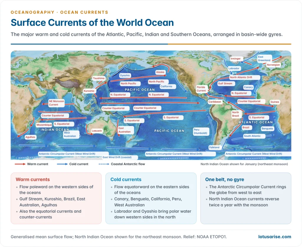
- Every ocean basin carries a system of surface currents: broad, wind-driven streams that move water, heat and salt over thousands of kilometres. The forces that set ocean currents in motion, wind stress, the Coriolis effect and density differences, produce the same basic pattern in each ocean, modified by its shape, its latitude and the winds over it.
- Each current is described by direction, temperature and cause. A warm current carries water from low to high latitudes and is warmer than the sea it enters; a cold current does the reverse.
- The label is relative. The Canary Current at 30°N is far warmer than the warm Norwegian Current at 65°N, yet it is cooler than the water around it.
- Transport is measured in sverdrups (Sv), after Harald Ulrik Sverdrup: 1 Sv is one million cubic metres of water per second, roughly the combined discharge of all the world’s rivers.
A common plan in every basin

- Equatorial currents flow westward under the trade winds: a North Equatorial Current and a South Equatorial Current in each ocean.
- Between them an Equatorial Counter Current flows eastward in the calm belt of the doldrums, returning water that the trades pile up against the western side.
- Because the thermal equator and the ITCZ lie north of the geographical Equator, the counter-current lies at about 3–10°N and the South Equatorial Current spills across the Equator.
- Subtropical gyres fill each basin between about 10° and 45°: clockwise in the Northern Hemisphere, anticlockwise in the Southern, centred under the subtropical highs.
- The western limb is narrow, deep, fast and warm: the Gulf Stream, Kuroshio, Brazil, East Australian and Agulhas Currents. This is westward intensification.
- The eastern limb is broad, shallow, slow and cold, with coastal upwelling: the Canary, California, Peru, Benguela and West Australian Currents.
- Subpolar gyres turn anticlockwise in the North Atlantic and North Pacific, bringing cold polar water south along the western sides (Labrador, Oyashio) and keeping the eastern sides warm (Norwegian, Alaska).
- The two hemispheres differ. The south has no subpolar gyres, because the open Southern Ocean lets the westerlies drive the Antarctic Circumpolar Current all round the globe. The North Indian Ocean has no permanent gyre at all, since its currents reverse with the monsoon.
| Feature | Northern Hemisphere gyre | Southern Hemisphere gyre |
|---|---|---|
| Sense of rotation | Clockwise | Anticlockwise |
| Poleward limb | Gulf Stream, Kuroshio (strong) | Brazil, East Australian, Agulhas (weaker, except Agulhas) |
| Poleward boundary | Westerly drifts feeding a subpolar gyre | West Wind Drift, part of the circumpolar current |
| Equatorward limb | Canary, California | Benguela, Peru, West Australian |
| Size | Bounded by continents to the north | Larger; open to the Southern Ocean |
The Atlantic Ocean
Currents of the North Atlantic
North Equatorial Current
- The warm North Equatorial Current flows westward between about 10° and 25°N, driven by the north-east trades. It is shallow, reaching a few hundred metres.
- It begins off north-west Africa, where the offshore trades push coastal water seaward and cold water upwells, so it starts cool and becomes warm and saline only as it crosses the open tropical ocean.
- Its path bends northward where it crosses the Mid-Atlantic Ridge near 15°N and back south beyond it, an example of bottom relief steering a surface current.
- Near the Lesser Antilles it splits:
- the Antilles Current runs north-west outside the Bahamas and joins the Florida Current;
- the Caribbean Current, reinforced by South Equatorial water carried across the Equator, crosses the Caribbean Sea and enters the Gulf of Mexico through the Yucatán Channel.
The Gulf Stream System
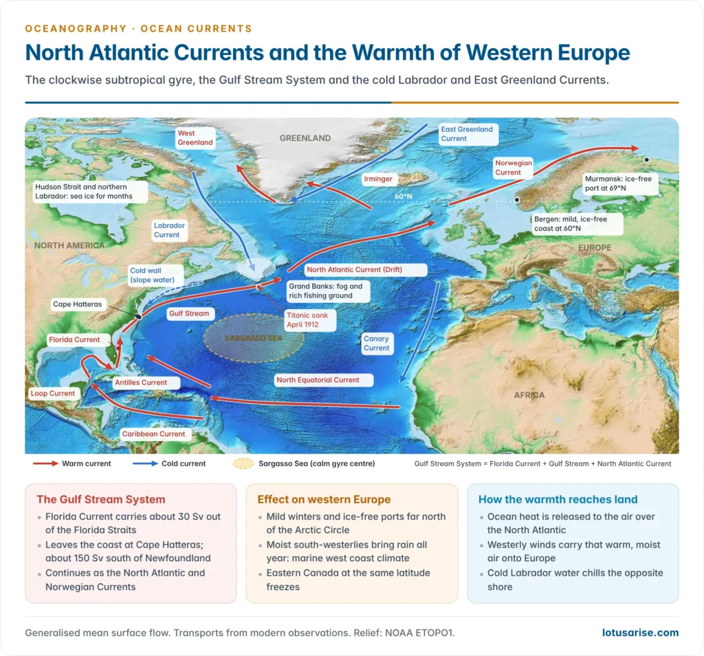
- The Gulf Stream System is the strongest warm current of the North Atlantic and the western limb of its subtropical gyre. It has three parts:
- the Florida Current, from the Florida Straits to Cape Hatteras;
- the Gulf Stream proper, from Cape Hatteras to the tail of the Grand Banks of Newfoundland;
- the North Atlantic Current (Drift), its eastward continuation towards Europe.
- Origin: water entering the Gulf of Mexico loops round as the Loop Current and leaves through the narrow Florida Straits.
- The trades pile water up in the Caribbean and the Gulf, so sea level there stands slightly higher than along the Atlantic coast, and the water rushes out as a jet.
- The deeper cause is westward intensification of the wind-driven gyre, explained by Henry Stommel (1948).
- Size and speed:
- The Florida Current carries about 30 Sv out of the Straits.
- Fed by the Antilles Current and by recirculating gyre water, the stream swells to about 150 Sv south of Newfoundland.
- It is about 100 km wide, reaches 800–1,200 m deep, and its surface speed is typically up to about 2.5 m/s, among the fastest of all ocean currents.
- Behaviour:
- It hugs the continental slope to Cape Hatteras (about 35°N), then leaves the coast and flows north-east into the open ocean.
- Beyond Hatteras it meanders and sheds warm-core rings to its north and cold-core rings to its south.
- Between the stream and the coast lies cold, fresher shelf and slope water partly fed by the Labrador Current, the cold wall. Here surface temperature can fall by 10 °C or more within a few tens of kilometres.
- History: the current was first recorded by the Spanish expedition of Juan Ponce de León off Florida in April 1513. Benjamin Franklin, with the Nantucket whaling captain Timothy Folger, printed the first chart of it in 1769–70 so that mail ships could avoid sailing against it.
- Recent change: cable measurements across the Florida Straits show the flow weakened by about 4% over roughly the past four decades. The finding was reported by Christopher Piecuch and Lisa Beal (2023).
- The Gulf Stream is the surface limb of the Atlantic Meridional Overturning Circulation, so its strength matters well beyond the Atlantic.
North Atlantic Current and its branches
- East of the Grand Banks the stream broadens into the North Atlantic Current, a slower, eddying drift pushed north-east by the westerlies and the Coriolis effect.
- It splits into several branches as it approaches Europe:
- the Norwegian Current flows along Norway into the Norwegian and Barents Seas; its extension, the North Cape Current, keeps the Murmansk coast ice-free;
- the Irminger Current runs west to south-west Iceland and Greenland, and feeds the West Greenland Current;
- smaller branches enter the Bay of Biscay, the English Channel and the North Sea;
- the southern branch turns south past the Azores and Iberia to become the Canary Current, closing the gyre.
- Part of the surface water enters the Mediterranean through the Strait of Gibraltar. Dense, salty Mediterranean water flows out beneath it at about 1,000 m and spreads through much of the North Atlantic.
Canary Current
- The cold Canary Current flows south along the coasts of Portugal and north-west Africa, from about Madeira to Cape Verde, and merges with the North Equatorial Current.
- It is cool for two reasons: it brings water from higher latitudes, and the offshore trades drive coastal upwelling that lifts cold, nutrient-rich water to the surface.
- Effects:
- It cools and dries the coast, reinforcing the aridity of the Sahara and the Western Sahara coast. It causes coastal fog.
- It gives the Canary Islands a mild, even climate.
- Its upwelling supports one of the world’s four great eastern-boundary fisheries, for sardine and anchovy.
Labrador and East Greenland Currents
- The cold Labrador Current flows south from Baffin Bay and the Davis Strait along Labrador and Newfoundland to the Grand Banks, where it meets the Gulf Stream. It carries Arctic water near freezing point and low in salinity.
- The East Greenland Current brings ice-laden water south from the Arctic through the Fram Strait, rounds Cape Farewell and partly joins it.
- Icebergs calved from Greenland’s glaciers drift south in the current every spring. The Titanic sank after striking one south of the Grand Banks in April 1912, and the International Ice Patrol was set up in 1914 to track them.
- Where the cold current meets the warm Gulf Stream:
- warm, moist air crossing cold water gives some of the densest sea fogs on Earth, a classic case of advection fog;
- mixing of nutrient-rich cold water with warm water made the Grand Banks one of the world’s richest cod fisheries, until overfishing caused its collapse and a moratorium in 1992.
- The current chills the coast of eastern Canada. Labrador’s coast is ice-bound for months at latitudes where western Europe stays mild.
The Gulf Stream and the climate of western Europe
- Western and northern Europe are far warmer in winter than their latitude suggests. The North Atlantic and Norwegian Currents keep the sea off Britain and Norway ice-free and much warmer than the latitude average.
- Ports stay open far north of the Arctic Circle: Narvik, Tromsø and Murmansk (69°N), while the Baltic and Hudson Bay freeze.
- Bergen (60°N) is mild and rainy, while northern Labrador and Hudson Strait at the same latitude carry sea ice for months.
- The effects reach well beyond temperature:
- Marine west coast climate: mild winters, cool summers and rain in all seasons from northern Portugal to Norway, with grassland, dairying and mixed farming suited to it. Nowhere else does this climate reach so far poleward.
- Rain and storms: the warm sea feeds the westerlies and their temperate cyclones with moisture.
- Fisheries: the shallow North Sea (Dogger Bank) and the waters off Norway and Iceland are rich fishing grounds.
- Navigation: the open sea routes to the Barents Sea depend on this warm water.
- How the warmth reaches land:
- The ocean gives up heat to the air over the North Atlantic, above all in winter.
- The prevailing south-westerlies carry that mild, moist maritime air mass onto Europe. Eastern North America, by contrast, receives cold continental air from the north-west.
- The current is not the whole story. Climate modelling by Richard Seager and colleagues (2002) showed that much of the winter contrast across the Atlantic comes from the atmosphere: the westerly winds, the wave pattern set up by the Rocky Mountains, and heat stored in the ocean’s mixed layer each summer.
- Ocean heat transport still adds a few degrees of winter warmth round the northern North Atlantic, most of all over the Norwegian Sea.
- This is why a weaker overturning circulation would cool north-west Europe even as the world as a whole warms.
The Sargasso Sea
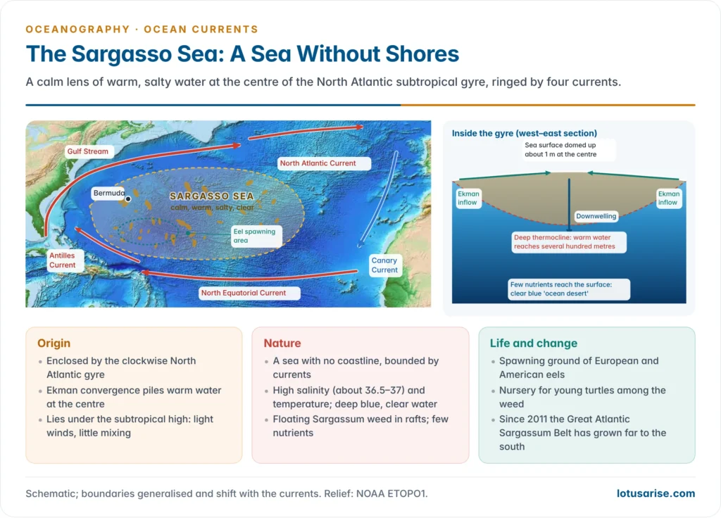
- The Sargasso Sea is the calm, warm water at the centre of the North Atlantic subtropical gyre. It is the only named sea with no coastline: its boundaries are four currents.
- the Gulf Stream to the west;
- the North Atlantic Current to the north;
- the Canary Current to the east;
- the North Equatorial Current to the south.
- Extent: it is commonly placed at about 20–40°N and 35–75°W, around Bermuda. Its edges shift because they are set by currents, not land.
- Origin:
- The clockwise gyre encloses the water and cuts it off from the rest of the ocean.
- Ekman transport of the surrounding winds drives surface water inward, so the sea surface stands about a metre higher at the centre and the water sinks slowly (downwelling).
- It lies under the subtropical high, where descending air brings light winds, clear skies and little mixing. These were the old “horse latitudes” in which sailing ships lay becalmed.
- Nature:
- The water is warm and highly saline (about 36.5–37), because evaporation is high and there is no inflow of fresh water.
- It is deep blue and very clear. Downwelling keeps nutrients deep, so the open water is an “ocean desert” with little plankton.
- It carries floating mats of the brown seaweed Sargassum, which reproduces without roots and drifts at the surface. The Portuguese sailors’ word sargaço gave the sea its name.
- Ecological value:
- The weed rafts shelter fish, crabs and young sea turtles.
- The southern Sargasso Sea is the only known spawning ground of the European and American eels. Johannes Schmidt located it in the 1920s from larval catches, and in 2022 satellite-tagged European eels were tracked into the sea for the first time.
- The Hamilton Declaration (March 2014) set up an international commission to protect the sea, which lies mostly beyond national jurisdiction.
- Recent change: since 2011 a separate Great Atlantic Sargassum Belt has bloomed across the tropical Atlantic from West Africa to the Caribbean. It reached a record in 2025, and its strandings now choke Caribbean and Gulf of Mexico beaches each year.
- Studies suggest an unusual wind pattern around 2010 carried weed from the Sargasso Sea into the tropics, where it now blooms on its own, fed by nutrients from the Amazon and African dust and by warmer water.
Currents of the Equatorial and South Atlantic
Equatorial currents
- The South Equatorial Current is stronger, steadier and broader than its northern partner, flowing west from the Gulf of Guinea between about 4°N and 15–20°S under the south-east trades.
- Off the eastern tip of Brazil (Cabo de São Roque) it divides:
- the North Brazil Current carries water across the Equator into the Northern Hemisphere and on to the Caribbean;
- the southern branch becomes the Brazil Current.
- The Equatorial Counter Current flows east at about 3–10°N. It is strong in the northern summer and weak or broken in winter, and continues as the Guinea Current along the coast of West Africa.
- Beneath the westward surface flow at the Equator, a thin, fast Equatorial Undercurrent runs east at about 100 m depth.
Brazil, Falkland and South Atlantic Currents
- The warm Brazil Current flows south along Brazil and is warm and highly saline. It is a weak western boundary current, carrying only a small fraction of the Gulf Stream’s water, because the South Atlantic gyre is weaker and much equatorial water leaks into the north.
- The cold Falkland (Malvinas) Current is a branch of the circumpolar current. It flows north along Patagonia and brings Antarctic water, and sometimes icebergs, towards the Río de la Plata.
- The two meet head-on at the Brazil–Malvinas Confluence (about 38°S), one of the most energetic, eddy-rich regions of the ocean and a rich fishing ground for squid and hake.
- The South Atlantic Current carries the combined flow east under the westerlies, along the northern edge of the West Wind Drift, to close the gyre.
Benguela Current
- The cold Benguela Current flows north along south-west Africa from the Cape of Good Hope towards Angola. It is fed by the South Atlantic Current and by strong coastal upwelling under the south-east trades.
- Effects:
- Its cold water is the main reason the Namib Desert is so dry. Air cooled over it is stable and gives coastal fog instead of rain, and the fog is a lifeline for Namib plants and beetles.
- Its upwelling makes it one of the most productive marine ecosystems, for sardine, anchovy and hake.
- Occasional warm intrusions from the north, called Benguela Niños, disrupt the fishery.
- Agulhas rings pinched off south of Africa carry warm, salty Indian Ocean water into the South Atlantic. This “leakage” adds salt to the upper limb of the overturning circulation.
| Feature | North Atlantic | South Atlantic |
|---|---|---|
| Gyre | Clockwise | Anticlockwise |
| Western boundary current | Gulf Stream: strong, about 30–150 Sv | Brazil Current: weak |
| Eastern boundary current | Canary (upwelling) | Benguela (stronger upwelling) |
| Poleward closure | North Atlantic Current to Europe and the Arctic | South Atlantic Current and West Wind Drift |
| Cold current on the western side | Labrador | Falkland |
| Gyre-centre sea | Sargasso Sea | No equivalent calm sea |
The Pacific Ocean
Equatorial Pacific
- The Pacific is the widest ocean, so its equatorial currents are the longest and largest.
- The North Equatorial Current flows west from off Mexico to the Philippines at about 8–20°N, a distance of more than 12,000 km. It is fed by the California Current at its eastern end and grows westward.
- East of the Philippines it divides: the Kuroshio turns north, and the Mindanao Current turns south to feed the counter-current.
- The South Equatorial Current is stronger and straddles the Equator, from about 4°N to 15–20°S. Off New Guinea it branches: one branch feeds the counter-current, and others turn south as the East Australian Current.
- The North Equatorial Counter Current flows east at about 3–10°N all year and is best developed in the northern summer. It carries some 20–25 Sv back towards Central America.
- The Equatorial Undercurrent (Cromwell Current) is a ribbon of fast eastward flow about 100–200 m below the westward surface current, described by Townsend Cromwell in the early 1950s. It is one of the strongest currents in the open ocean.
- The equatorial Pacific is the stage of ENSO.
- The trades push warm water west, so the western Pacific warm pool stands higher and warmer and the east upwells cold water.
- When the trades weaken, warm water surges east and suppresses the cold upwelling off Peru. This is El Niño, and its reverse is La Niña.
- The old name “El Niño current” first described a warm southward coastal flow off Ecuador and northern Peru around Christmas.
Currents of the North Pacific
The Kuroshio System
- The warm Kuroshio (“Black Current”, from the deep indigo of its clear water) is the Pacific counterpart of the Gulf Stream.
- It flows north-east from east of Taiwan past the Ryukyu Islands and along southern Japan, about 100 km wide, with a mean surface temperature near 24 °C.
- Its transport rises from about 25–30 Sv in the East China Sea to about 65 Sv south-east of Japan, where gyre water recirculates into it.
- It leaves the coast near the Bōsō Peninsula (about 35°N) and continues east as the meandering Kuroshio Extension, which merges into the North Pacific Current.
- Branches:
- The Tsushima Current enters the Sea of Japan through the Korea Strait. Winter monsoon air crossing this warmed sea picks up moisture and dumps heavy snow on Japan’s western coast.
- A Kuroshio Counter Current recirculates south-west on its seaward side.
- The Kuroshio switches between paths. Its large meander, a southward loop off central Japan, began in August 2017 and ended in April 2025. At 7 years and 9 months it was the longest since records began in 1965, and it shifted fishing grounds and raised coastal sea levels.
- Effects: it warms and moistens the climate of southern and eastern Japan and Taiwan, nourishes coral reefs as far north as about 33°N, and fuels the typhoons that cross it.
Oyashio and the fishing grounds off Japan
- The cold Oyashio (“parent current”, for the life it nourishes) flows south-west from the Bering Sea and the Sea of Okhotsk past Kamchatka and the Kuril Islands to north-eastern Japan. It is cold, fresh and rich in nutrients, the Pacific counterpart of the Labrador Current.
- It meets the Kuroshio off Sanriku (north-eastern Honshu) in a broad mixed-water zone of fronts and eddies.
- This confluence is one of the world’s great fishing grounds, for saury, sardine, mackerel, squid and salmon. Japan’s fishing industry grew round it.
- Warm air crossing the cold Oyashio brings dense summer sea fog to Hokkaido and the Kurils, as off Newfoundland.
North Pacific, Alaska and California Currents
- The North Pacific Current (Drift) carries Kuroshio water east under the westerlies to about 150°W, where it divides.
- The warm Alaska Current turns north into the Gulf of Alaska and runs anticlockwise round the subpolar gyre. As the Alaskan Stream it flows west along the Aleutians.
- It keeps the coast of southern Alaska mild and its ports ice-free; Valdez is the northernmost ice-free port of the United States.
- The cold California Current flows south from about 48°N to Baja California, then turns west into the North Equatorial Current.
- From spring to late summer the northerly winds drive coastal upwelling. Upwelled water is coldest off northern California and supports rich fisheries and kelp forests.
- Moist air crossing the cold water gives the famous summer fogs of San Francisco. The current also keeps the summer dry and cool, the hallmark of a Mediterranean climate.
- In winter, when upwelling stops, a coastal counter-current, the Davidson Current, flows north inshore.
- Recent change: a persistent marine heatwave, “the Blob”, spread across the north-east Pacific from 2013 to 2016. It caused toxic algal blooms, seabird die-offs and fishery closures along the California Current.
Currents of the South Pacific
East Australian Current
- The warm East Australian Current flows south along Australia’s east coast from the Coral Sea. It is a western boundary current, but weaker and far more eddy-dominated than the Gulf Stream or Kuroshio.
- Near 30–35°S it separates from the coast and turns east across the Tasman Sea towards New Zealand, while warm eddies carry on south towards Tasmania.
- It warms the coast of New South Wales. It is strengthening and pushing further south, and the Tasman Sea has become a global warming hotspot, carrying tropical fish and marine heatwaves towards Tasmania.
Peru (Humboldt) Current
- The cold Peru Current, also called the Humboldt Current, flows north along Chile and Peru and turns west into the South Equatorial Current near the Equator.
- It is named after Alexander von Humboldt, who measured its coldness in 1802.
- It is a broad, slow eastern boundary current, up to about 900 km wide, fed by the West Wind Drift and by sub-Antarctic water.
- Upwelling under the south-east trades is strongest between about 5° and 15°S off Peru, bringing cold, nutrient-rich water to the surface.
- It supports the world’s largest single-species fishery, the Peruvian anchoveta, and the seabird colonies whose guano was once a major export.
- Effects on the coast:
- Air cooled from below becomes stable, so rain is almost unknown. The Atacama Desert is one of the driest places on Earth.
- Low stratus and drizzle, called garúa in Peru and camanchaca in Chile, hang over the coast for much of the year. In places, fog-catching nets harvest the water.
- The coast is far cooler than its tropical latitude suggests.
- El Niño breaks the system. When warm water spreads east, upwelling stops, the anchoveta crash, seabirds starve, and heavy rain floods the normally dry coast of Peru and Ecuador.
West Wind Drift
- The cold West Wind Drift, also called the South Pacific Current, flows east between about 40° and 55°S under the Roaring Forties, from Tasmania and New Zealand towards South America.
- Off Chile it divides: part turns north to feed the Peru Current, and part passes round Cape Horn into the Atlantic.
Pacific currents and coastal climates
- Warm currents on the western side of the Pacific warm and moisten the coasts they wash. Cold currents on the eastern side cool, stabilise and dry them.
| Coast | Current | Climatic effect |
|---|---|---|
| Peru and northern Chile | Peru (cold) | Atacama aridity, garúa fog, cool coast; anchoveta fishery |
| California | California (cold) | Summer fog, cool dry summers, Mediterranean climate |
| Southern Alaska and British Columbia | Alaska (warm) | Mild, very wet winters; ice-free ports |
| Southern and eastern Japan, Taiwan | Kuroshio (warm) | Warm, humid; typhoon fuel; reefs far north |
| Hokkaido, Kurils, Kamchatka | Oyashio (cold) | Cold coast, summer sea fog, frozen winter seas |
| Eastern Australia | East Australian (warm) | Warm, humid; rain on the east coast |
| Ecuador and Peru in El Niño years | Warm water replaces upwelling | Floods on a desert coast; fishery collapse |
| Feature | Gulf Stream | Kuroshio |
|---|---|---|
| Ocean | North Atlantic | North Pacific |
| Origin | Florida Straits (Florida Current) | East of Taiwan (from the North Equatorial Current) |
| Leaves the coast | Cape Hatteras, about 35°N | Bōsō Peninsula, about 35°N |
| Transport | About 30 Sv, rising to about 150 Sv | About 25–30 Sv, rising to about 65 Sv |
| Continuation | North Atlantic Current to Europe and the Arctic | Kuroshio Extension and North Pacific Current |
| Cold partner | Labrador Current | Oyashio |
| Distinctive behaviour | Rings and meanders; weakening by about 4% in 40 years | Large meander of 2017–25 |
The Indian Ocean
How the Indian Ocean differs
- The Indian Ocean is closed by Asia at about 25°N. Its northern half is two tropical seas, the Arabian Sea and the Bay of Bengal, under the reversing monsoon winds.
- As a result, three features set it apart:
- North of about 10°S, currents reverse twice a year with the monsoon. No permanent North Equatorial Current or northern gyre exists.
- The mean winds at the Equator are weak westerlies, not trades, so the South Equatorial Current lies well south, at about 10–20°S.
- It receives warm Pacific water through the Indonesian seas, the Indonesian Throughflow. The INSTANT measurements of 2004–06 put it at about 15 Sv, through the Lombok and Ombai Straits and the Timor Passage.
- South of about 10°S the circulation is a steady anticlockwise gyre, like those of the South Atlantic and South Pacific.
North Indian Ocean: the monsoon currents
Southwest (summer) monsoon, June to September
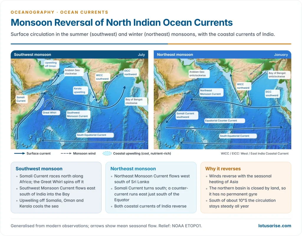
- The Somali Current reverses and flows north along the coast of Somalia as one of the fastest currents in the ocean, with speeds of 3.5 m/s or more (about 7 knots) in June.
- It is fed by the East African Coastal Current from the south, and swings offshore in the Great Whirl, a clockwise eddy 400–600 km across at about 5–10°N.
- The strong south-westerly Findlater jet along the coast drives intense upwelling off Somalia and Oman, cooling the sea by 5 °C or more.
- This makes the western Arabian Sea one of the most productive seas on Earth, and its decaying plankton leave a vast oxygen minimum zone at mid-depth.
- The Southwest Monsoon Current flows east south of India and Sri Lanka, then turns north-east into the Bay of Bengal.
- Arabian Sea: the circulation is clockwise. The West India Coastal Current (WICC) flows southward, and upwelling off Kerala feeds the oil sardine and mackerel catch.
- Bay of Bengal: the East India Coastal Current (EICC) flows northward. It is strongest in March–April, before the monsoon, when it runs as a western boundary current of a clockwise gyre; during the monsoon it is weaker and broken by eddies.
Northeast (winter) monsoon, November to February
- The Northeast Monsoon Current (also called the Winter Monsoon Current) flows west south of Sri Lanka and India, carrying low-salinity water from the Bay of Bengal into the south-eastern Arabian Sea.
- The Somali Current reverses and flows south. It meets the northward East African Coastal Current near the Equator and turns east as the Equatorial Counter Current, at about 2–8°S, from off Zanzibar towards Sumatra.
- Bay of Bengal: the EICC flows southward (October to January) and the circulation is anticlockwise. It carries fresh Bay water round Sri Lanka.
- Arabian Sea: the WICC flows northward (poleward), against the prevailing wind, and the circulation is anticlockwise.
- Coastal waves from the Bay of Bengal drive this reversal, and they also form a sea-level high off south-west India in winter, the Lakshadweep High, and a low in summer, the Lakshadweep Low.
Transition seasons: the Wyrtki jets
- In the gaps between the monsoons, in May and November, westerly winds over the equatorial ocean drive a strong eastward surface jet along the Equator.
- These are the Wyrtki jets, first described by Klaus Wyrtki (1973). They often exceed 1 m/s and carry warm water towards Sumatra.
- They deepen the warm layer in the east, and their strength is tied to the Indian Ocean Dipole, which in turn affects the Indian monsoon.
| Feature | Southwest monsoon (summer) | Northeast monsoon (winter) |
|---|---|---|
| Wind | South-westerly, strong | North-easterly, weaker |
| Main open-ocean current | Southwest Monsoon Current, eastward | Northeast Monsoon Current, westward |
| Somali Current | Northward, very fast; Great Whirl | Southward, weak |
| Arabian Sea circulation | Clockwise | Anticlockwise |
| Bay of Bengal circulation | Clockwise (EICC northward) | Anticlockwise (EICC southward) |
| West India Coastal Current | Southward | Northward |
| Upwelling | Strong off Somalia, Oman and Kerala | Weak |
| Equatorial Counter Current | Merged with the monsoon current | Distinct, eastward at about 2–8°S |
- Why the link between winds and currents is clearest here:
- The ocean responds to a wind reversal within weeks, so the whole current system flips with the season, which happens nowhere else on this scale.
- Land closes the north, so there is no steady gyre to smooth the change.
- The trade-wind-driven south of the ocean stays steady, which shows by contrast how directly the north follows the wind.
- Observing it from India:
- INCOIS (Hyderabad) is a partner in the RAMA moored-buoy array across the tropical Indian Ocean and issues daily Ocean State Forecasts of currents and waves.
- It also issues Potential Fishing Zone advisories, which track fronts and upwelling.
- Its Search and Rescue Aided Tool (SARAT), upgraded in February 2025, uses forecast currents to predict where a drifting boat or person will be.
South Indian Ocean
- The South Equatorial Current flows west at about 10–20°S all year, fed by the Indonesian Throughflow. It is strongest in the southern winter.
- At Madagascar it divides:
- the East Madagascar Current runs south along the island’s east coast;
- flow through the Mozambique Channel moves mainly as a train of large eddies, the older “Mozambique Current”.
- Both feed the warm Agulhas Current, which flows south-west along the coast of South Africa.
- It is the strongest western boundary current of the Southern Hemisphere, carrying about 70 Sv, a narrow jet under 100 km wide.
- South of Africa it turns sharply back (retroflects) into the Indian Ocean as the Agulhas Return Current.
- Giant Agulhas rings that break off the retroflection carry warm, salty water into the Atlantic, an estimated 2–15 Sv.
- Where storm swells from the Southern Ocean run against the fast current off the Wild Coast, freak waves have damaged large ships.
- The West Wind Drift (here also called the South Indian Current) carries water east at about 40–50°S under the Roaring Forties.
- West Australian waters: the gyre’s broad, weak, cool West Australian Current flows north offshore.
- Inshore, the Leeuwin Current, unusually for an eastern boundary, carries warm tropical water south along the coast and round Cape Leeuwin, strongest in the southern winter. It is driven by the higher sea level of the warm water that comes through the Indonesian seas.
- It suppresses upwelling, which is why Western Australia has no large upwelling fishery. It allows coral reefs as far south as the Houtman Abrolhos Islands.
- In 2011, during a strong La Niña, a surge of the current caused the Ningaloo Niño marine heatwave, with water up to about 5 °C above normal, coral bleaching and fish kills.
The Southern and Arctic Oceans
Antarctic Circumpolar Current
- The Antarctic Circumpolar Current (ACC), the West Wind Drift of older texts, is the only current that flows all the way round the Earth. It runs eastward between about 40° and 60°S, linking the Atlantic, Indian and Pacific Oceans.
- Origin:
- Driven by the strong westerlies of the Roaring Forties, Furious Fifties and Shrieking Sixties.
- Free to circle the globe because no land blocks the latitude band except the narrow Drake Passage (about 800 km wide) between Cape Horn and the Antarctic Peninsula.
- Steered by density: the dense, cold water round Antarctica makes the surfaces of equal pressure slope northward, and the current flows along that slope at all depths.
- Size: it is the largest current on Earth. Measurements across the Drake Passage put its mean transport at about 173 Sv, roughly 30% more than the older estimate of 134 Sv.
- It is slow, at a few tens of centimetres per second, but reaches to the sea floor.
- Bottom relief deflects it. The Kerguelen Plateau, the Macquarie Ridge and the Pacific–Antarctic Ridge bend its path, and branches turn north as the Falkland, Benguela and Peru Currents.
- Structure:
- It flows in jets along fronts: the Subantarctic Front and the Polar Front (Antarctic Convergence), where cold Antarctic surface water sinks beneath warmer water.
- Closer to the continent, the Antarctic Divergence lifts deep water to the surface.
- Next to the coast, the polar easterlies drive a westward Antarctic Coastal Current (East Wind Drift), which feeds the clockwise Weddell and Ross Sea gyres.
- Significance:
- It thermally isolates Antarctica, keeping its ice cap cold. Its onset, after the Drake Passage and the Tasmanian gateway opened around the Eocene–Oligocene boundary (about 34 million years ago), helped glaciate the continent.
- It mixes water between all three oceans and is a major sink for heat and carbon dioxide.
- A 2025 modelling study projected that meltwater from Antarctica could slow it by about 20% by 2050 under high emissions.
Arctic Ocean
- The Arctic Ocean has two main surface movements:
- the clockwise Beaufort Gyre north of Alaska and Canada, which stores fresh water;
- the Transpolar Drift, which carries ice and water from the Siberian shelves across the North Pole to the Fram Strait.
- Fridtjof Nansen proved the drift by letting his ship Fram freeze into the ice and drift with it (1893–96).
- Exchange with the other oceans:
- Out: water and ice leave through the Fram Strait as the cold East Greenland Current.
- In: warm Atlantic water enters through the Fram Strait (the West Spitsbergen Current) and the Barents Sea. A little Pacific water, about 1 Sv, enters through the Bering Strait.
- Atlantification: the warm, salty Atlantic inflow normally sinks beneath the fresher Arctic surface layer. It is now rising closer to the surface in the Barents Sea and the Eurasian basin, so sea ice is melted from below as well as from above. India studies these changes from its Arctic station Himadri at Ny-Ålesund, Svalbard.
Major currents at a glance
| Ocean | Warm currents | Cold currents |
|---|---|---|
| North Atlantic | North Equatorial, Antilles, Caribbean, Florida, Gulf Stream, North Atlantic, Norwegian, Irminger | Labrador, East Greenland, Canary |
| South Atlantic | South Equatorial, North Brazil, Brazil, Guinea | Falkland, Benguela, South Atlantic (West Wind Drift) |
| North Pacific | North Equatorial, Kuroshio, Tsushima, North Pacific, Alaska | Oyashio, California |
| South Pacific | South Equatorial, East Australian, Counter Equatorial | Peru (Humboldt), West Wind Drift |
| Indian Ocean | Monsoon currents, Somali (outside upwelling), South Equatorial, Agulhas, Mozambique and East Madagascar, Leeuwin | West Australian, West Wind Drift; upwelled water off Somalia and Oman |
| Southern Ocean | — | Antarctic Circumpolar Current, Antarctic Coastal Current |
| Arctic Ocean | Norwegian and West Spitsbergen inflow | Transpolar Drift, East Greenland |
Previous Year Questions
2023How are ocean currents generated? Discuss their effects on coastal climates with special reference to the Pacific Ocean.2022What is the relationship between ocean currents and global surface wind systems? Explain with examples how does the gyre in the Northern Hemisphere differ from the one in the Southern Hemisphere.2020Explain the currents of the North Atlantic Ocean and their significant role in the climate of western Europe.2016“The relationship between the winds and the currents is best seen in the Indian Ocean.” Justify.2014Illustrate the origin and nature of Sargasso Sea and Lagoon.2006Write short note: ocean currents of Northern Atlantic Ocean.1987Give a reasoned account of the currents of the Atlantic Ocean and their impact on the climatic conditions of the coastal regions.




