

- A temperate cyclone is a low-pressure system of the middle and high latitudes (about 35°–65° N and S), with air converging and rising round a low centre: anticlockwise in the northern hemisphere and clockwise in the southern.
- It forms where warm tropical and cold polar air masses meet along the polar front, and it carries warm, cold and occluded fronts. Its other names reflect this: extratropical cyclone, mid-latitude cyclone, frontal cyclone, wave cyclone or simply depression.
- Carried eastward by the westerlies and steered by the jet stream above, a procession of these cyclones and the highs between them produces the changeable, cloudy and rainy weather of the temperate lands and much of their annual precipitation.
- Its energy comes from the horizontal temperature contrast between air masses, which makes it cold-core and fundamentally different from the warm-core tropical cyclone.
Characteristics and Distribution
Characteristics
- Shape: isobars are roughly circular or elliptical; in many depressions they bend into a V-shape (a V-shaped depression), with the long axis aligned south-west to north-east. Very broad, shallow lows appear as troughs.
- Size: highly variable, from about 150 to over 3,000 km across, most commonly 1,000–2,000 km; they are much larger than tropical cyclones and extend through the troposphere, about 10–12 km deep.
- Pressure: the central pressure is typically 10–20 hPa below the margins, and in deep winter storms 35 hPa or more; the deepest North Atlantic lows fall below 950 hPa.
- Winds: generally moderate, since the pressure gradient is gentle, but gales blow in deep lows, usually strongest on the southern side of the centre in the northern hemisphere.
- Movement: west to east with the westerlies, often curving north-east, at about 1,000 km a day on average (500–2,000 km), faster in winter. People in the westerly belt look west for the coming weather.
- Life span: about five to seven days; a cyclone takes two to four days to pass over a place.
- Season: most numerous and intense in winter, when the polar–tropical contrast is greatest; weaker and fewer, and displaced poleward, in summer.
- Formation: over both land and sea, unlike tropical cyclones, which form only over warm oceans.
Distribution and Tracks
| Breeding ground | Air masses involved | Track and effects |
|---|---|---|
| North-west Pacific (off Japan) and Gulf of Alaska | cP from Asia and mT from the Pacific | North-east to the Aleutian low; winter rain on the coast from Alaska to California |
| Lee of the Rockies: Alberta lows and Colorado lows; east of the Sierra Nevada | Regenerated Pacific lows meeting cP and mT air | East and north-east to the Great Lakes; blizzards, heavy snow, cold waves |
| Gulf of Mexico and Atlantic coast of the USA | mT from the Gulf and cP | North-east along the coast; nor’easters |
| North Atlantic (Iceland to the Barents Sea) | mP, mT and Arctic air | East over north-western Europe, Scandinavia and northern Russia; merge with the Icelandic low |
| Baltic Sea | Warm sea against cold land | Winter storms over northern Europe |
| Mediterranean basin | Cool European air and warm North African air | East and north-east to Russia, the Middle East and north-west India (western disturbances) |
| Southern Ocean | mP and Antarctic air | Round the Antarctic all year |
- The densest storm tracks converge on the Aleutian and Icelandic lows, the graveyards where old cyclones occlude and fill.
- In summer, the tracks shift poleward: subtropical and warm temperate areas get few cyclones, while the Bering Strait and the Arctic fringes of America and Russia get many.
Non-frontal Lows of the Middle Latitudes
- Not every mid-latitude low is a frontal wave cyclone:
- Thermal (heat) lows: shallow summer lows over hot deserts that hardly move, such as the low over the Persian Gulf–Pakistan region.
- Lee depressions: form where the westerlies cross a mountain barrier, such as the lows south of the Alps and east of the Rockies; they often acquire fronts later.
- Polar lows: small, intense winter storms in cold, unstable mP air over high-latitude seas.
- Decayed tropical cyclones entering the westerlies, which may re-intensify as extratropical storms.
Origin of Temperate Cyclones
Early Ideas
- Robert FitzRoy (1863) first linked these storms to the meeting of warm, humid air from the subtropics and cold, dry polar air.
- Ralph Abercromby (1887) drew a model cyclone showing the weather in its different sectors.
- William Napier Shaw and Rudolf Gustav Karl Lempfert (1906) traced the air currents feeding these storms and put the air-stream idea on a scientific footing.
Polar Front Theory
- Proponents: the Bergen school in Norway, led by Vilhelm Bjerknes, with Jacob Bjerknes, Halvor Solberg and Tor Bergeron. Jacob Bjerknes described the structure of moving cyclones in 1919; Jacob Bjerknes and Halvor Solberg (1922) set out their life cycle on the polar front. It is also called the wave theory, the frontal theory or the Norwegian cyclone model.
- Assumptions:
- The middle latitudes are a zone of convergence where cold polar air (from the polar highs) and warm tropical air (from the subtropical highs) meet along the polar front.
- The two air streams flow parallel to the front in opposite directions: easterly on the cold side, westerly on the warm side.
- The front is not fixed: it shifts north and south with the seasons and the jet stream.
- Mechanism:
- A small disturbance (relief, a temperature contrast, or a trough in the flow aloft) bends the front into a wave.
- Stable waves die out; unstable waves, with wavelengths of about 500–3,000 km, grow in amplitude.
- At the crest of the wave, warm air pushes poleward and upward over the cold air (the warm front), while cold air pushes equatorward, undercutting the warm air behind it (the cold front). The Coriolis force turns this into a cyclonic circulation round a deepening low.
- The cyclone draws its energy from the sinking of cold, dense air and the rising of warm, light air, which converts the potential energy of the temperature contrast into kinetic energy, together with the latent heat released in the rising air.
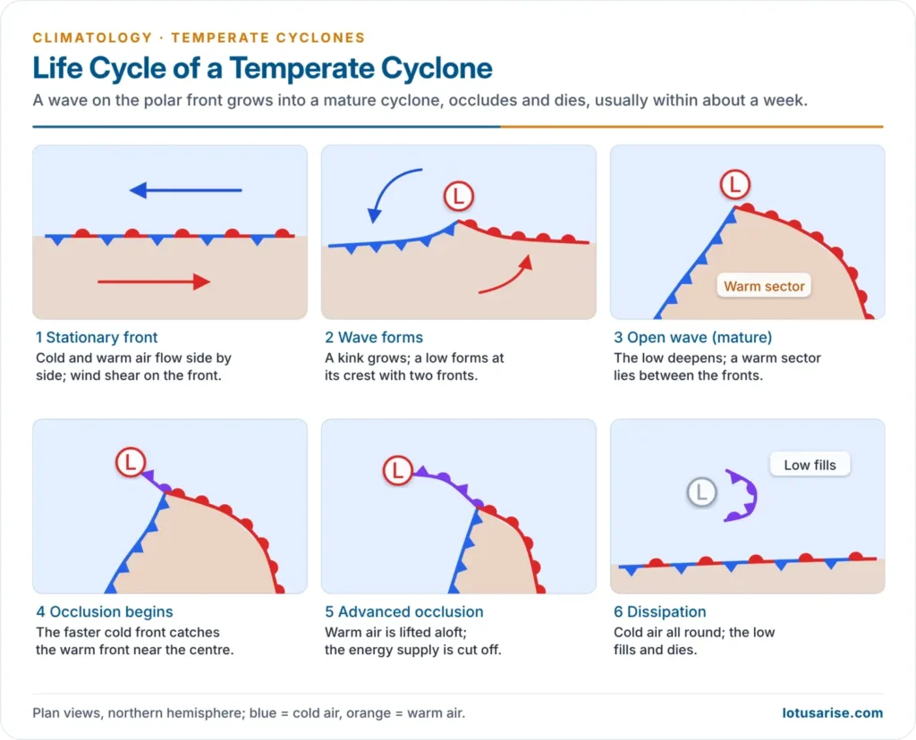
Life Cycle of a Temperate Cyclone
- Initial stage: a stationary front separates cold easterly and warm westerly air flowing parallel to it, with wind shear across the front. The weather is fair.
- Incipient (wave) stage: a wave forms; cold air turns equatorward and warm air poleward, and a weak cyclonic circulation develops round a new low at the wave’s apex (cyclogenesis). The warm and cold fronts appear.
- Mature (open-wave) stage: the low deepens; a well-defined warm sector lies between the warm front ahead and the cold front behind. Precipitation is broad and steady along the warm front and narrow and heavy along the cold front.
- Occlusion stage: the faster cold front catches up with the warm front, starting near the centre, and lifts the warm sector off the ground, forming an occluded front. The storm is often at its most intense as occlusion begins.
- Dissipating stage: with the warm air lifted aloft, the horizontal temperature contrast at the surface is gone, cutting off the cyclone’s energy supply. Cold air surrounds the centre, pressure rises and the cyclone becomes a feeble vortex that fills and dies.
Cyclone Families and Secondary Cyclones
- Temperate cyclones seldom come alone. A family of three to five cyclones forms along the trailing cold front, each at a more equatorward position than the last, the leading one occluded and the youngest incipient.
- A secondary cyclone may also develop on the trailing cold front or at the point of occlusion of a mature cyclone, and grow rapidly.
- The family ends with an outbreak of polar air that builds a polar-outbreak anticyclone; ridges of high pressure separate the members of the family and give spells of clear, fine weather between storms.
- Through such families, the cyclones carry much of the poleward transfer of heat and moisture in the middle latitudes.
Evaluation of the Polar Front Theory
- Strengths:
- It explained the structure, weather sequence and life cycle of the cyclone so well that it became the basis of weather forecasting and is still used on weather maps.
- It linked cyclones to air masses and fronts, uniting the two concepts.
- Limitations:
- It is based on surface observations; it does not explain why a wave grows on one part of the front and not another.
- Many cyclones form without a pre-existing front, and many intense oceanic storms do not occlude in the way it describes.
- Occlusion is not always the decay stage: storms often deepen while occluding.
- It ignored the controlling role of the upper-air flow.
Upper-Air (Dynamic) Theory
- Upper-air observations from the 1930s onward and later satellites showed that surface cyclones are tied to the waves of the upper westerlies.
- Rossby waves and the jet stream:
- The upper westerlies form large ridges and troughs, the long waves described by Carl-Gustaf Rossby (1939), with the jet stream at their core.
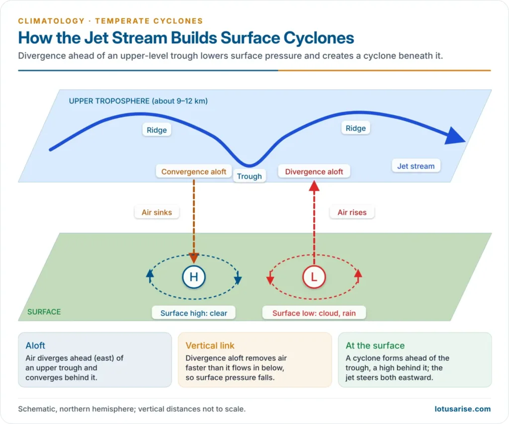
- Ahead (east) of an upper trough, air diverges aloft. Upper divergence removes air from the column faster than surface inflow replaces it, so surface pressure falls and a surface cyclone develops beneath, drawing air in and up.
- Behind the trough, air converges aloft and sinks, building a surface anticyclone.
- The surface cyclone therefore forms ahead of the upper trough and moves in the direction of the upper flow, so the jet stream steers the storm.
- Baroclinic instability: Jule Gregory Charney (1947) and Eric Thomas Eady (1949) showed mathematically that a westerly flow with a strong north–south temperature gradient is unstable to waves a few thousand kilometres long; these grow by releasing the potential energy of the temperature contrast. This is today’s core explanation of cyclogenesis.
- Link with frontogenesis: the deformation field along the polar front, with the isotherms packed along its axis of dilatation, concentrates the temperature gradient; this is the baroclinic zone on which the cyclone grows, and the circulation of the growing cyclone in turn sharpens its fronts.
- Conveyor belts: satellite studies show the cyclone as three air streams: a warm conveyor belt rising from the warm sector over the warm front (producing the main cloud shield and rain), a cold conveyor belt flowing westward beneath it ahead of the warm front, and a dry intrusion of sinking upper air behind the cold front that gives the comma-shaped cloud its clear slot.
- Shapiro–Keyser model: Melvyn A. Shapiro and Daniel Keyser (1990) described a second life cycle, common over the oceans: the cold front fractures from the warm front, a bent-back warm front wraps round the centre, and a warm seclusion forms instead of a classical occlusion.
- Explosive cyclogenesis: a cyclone whose central pressure falls by at least 24 hPa in 24 hours (adjusted to 60° latitude) is called a bomb, a definition set by Frederick Sanders and John R. Gyakum (1980). Storm Éowyn (24 January 2025) deepened explosively over the Atlantic and gave Ireland a record gust of 183 km/h at Mace Head.
Structure and Weather
Structure
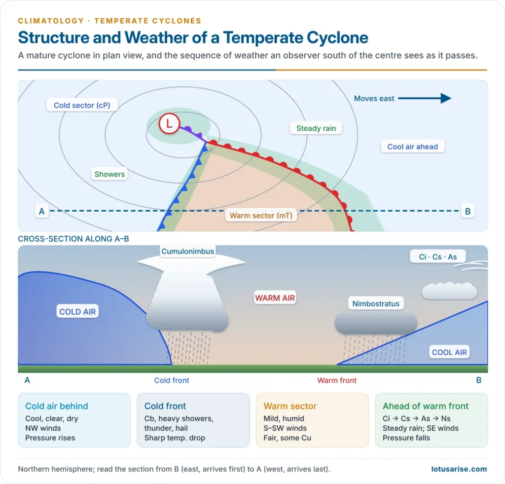
- In the northern hemisphere, a mature cyclone has:
- a warm sector of mT air in its southern part, bounded by the warm front to the east and the cold front to the west
- a cold sector of polar air surrounding the rest of the low, to the north, east and west of the centre
- Precipitation is widespread ahead of the warm front (several hundred km wide), concentrated in a narrow belt along the cold front, and prolonged near the occluded front north of the centre.
- Temperature, wind and weather are discontinuous: they change abruptly at each front.
Sequence of Weather
- The weather an observer sees depends on whether the centre passes to the north or the south.
- Centre passing to the north (observer in the path of the warm sector):
- Warm front approach: cirrus and cirrostratus with a halo appear 1,000 km or more ahead, then altostratus; the pressure falls, winds back to the south-east and freshen, and steady rain or snow falls from nimbostratus.
- Warm sector: after the warm front passes, the wind veers to the south or south-west, temperature and humidity rise, the rain stops and the sky clears partly; the pressure fall stops.
- Cold front: a wall of cumulonimbus gives heavy showers, thunder, hail and sometimes tornadoes, often preceded by a squall line.
- Cold sector: the wind veers sharply to the west or north-west, the temperature drops, pressure rises and the sky clears quickly in cold, dry polar air.
- Centre passing to the south (observer in the cold sector): there is no warm sector. The sky thickens from cirrus to nimbostratus, the weather stays cold, winds back from east through north to north-west, and prolonged rain, snow or ice storms fall from the slow-moving occluded front.
Anticyclones in the Cyclone Belt
- Anticyclones accompany temperate cyclones as ridges between members of a family and as polar-outbreak highs behind the last one; their subsiding, diverging air brings clear, dry weather, cold waves in winter and heat waves in summer.
- Blocking highs: large, deep warm-core highs over the eastern North Atlantic–Europe and the north-east Pacific block the eastward march of cyclones for days or weeks, diverting them north or south and causing prolonged droughts, heat waves or floods on either side.
Temperate and Tropical Cyclones Compared
| Feature | Temperate cyclone | Tropical cyclone |
|---|---|---|
| Latitude | About 35°–65° N and S | About 5°–30° N and S |
| Origin | Over land and sea, on the polar front | Only over warm seas (above about 26.5 °C) |
| Energy source | Horizontal temperature contrast (baroclinic) | Latent heat of condensation |
| Core | Cold-core; asymmetric | Warm-core; symmetric, with an eye |
| Fronts | Warm, cold and occluded fronts | No fronts |
| Size | Large: about 1,000–3,000 km | Smaller: a few hundred km |
| Isobars and gradient | V-shaped or oval; gentle gradient | Closely spaced circles; very steep gradient |
| Winds | Moderate; gales in deep lows | Very strong, strongest round the eye |
| Movement | West to east with the westerlies | East to west with the trades, then recurving poleward |
| Rain | Moderate, over large areas, for days | Torrential, near the centre, for a short time |
| Life span | About five to seven days | About a week; dies over land or cool water |
| Season | Mainly winter | Late summer and autumn |
- The two can turn into each other: a tropical cyclone moving poleward can undergo extratropical transition, acquiring fronts and a cold core, and rare lows like the medicanes of the Mediterranean show tropical features in a mid-latitude setting.
Western Disturbances
- Western disturbances (WDs) are the eastward-moving extratropical lows that bring winter weather to north-west India. They are upper-level troughs in the subtropical westerly jet, often linked with lows that form over the Mediterranean, are refreshed over the Caspian and Persian Gulf, and cross Iran, Afghanistan and Pakistan.
- By the time they reach India, they have usually lost their surface fronts; they appear as an upper trough with an induced low over Pakistan and Rajasthan.
- Frequency: about five to seven strong WDs a month cross northern India in winter (December–March), many more than in summer.
- Weather in India:
- Rain over Punjab, Haryana, Delhi and western Uttar Pradesh, and snow over Jammu and Kashmir, Ladakh, Himachal Pradesh and Uttarakhand; this water sustains the rabi wheat and mustard crops and the Himalayan snowpack.
- Cold waves, fog and frost follow as cold north-westerly air spreads behind them.
- Hailstorms and dust storms in late winter and spring can damage standing crops.
- When they fail, the winter turns dry: in January 2024, Himachal Pradesh recorded its driest January since 1901, and in January 2025 most of the WDs reaching north India lacked moisture and gave little rain.
- Interaction with the monsoon: a WD meeting monsoon air over the Himalaya produces extreme rain, as in the Uttarakhand (Kedarnath) disaster of June 2013 and the north Indian floods of July 2023 in Himachal Pradesh.
- Changing pattern: a 2024 study of records from 1950 to 2022 found winter WDs becoming more frequent over the western Himalaya and the season lengthening into April–July, because the subtropical jet has strengthened and retreats north later; June WDs have doubled in the last two decades, raising the risk of such monsoon-season floods.
Previous Year Questions
2026Examine the importance of axis of dilation of airmasses in frontogenesis and the origin of Temperate cyclones.2024Formation of temperate cyclone depends on the condition of axis of dilation. Elucidate.2021Explain the impact of tropical cyclones and western disturbances on the climate of India.2016Compare the origin and weather conditions associated with tropical and temperate cyclones.2012Compare and contrast tropical cyclone and temperate cyclone.2010What is ‘polar front’? How does cyclone develop along this front? Describe the weather conditions associated with it.2006Compare the structure and associated weather conditions of tropical cyclone with that of temperate cyclone.1999Make a comparative study of the tropical and temperate cyclones.1995Explain and illustrate the life-cycle of a temperate cyclone and also describe the weather associated with it.1989Explain the origin, characteristics and distribution of temperate cyclones.1987Discuss critically the characteristics of tropical cyclones and analyse the extent to which they differ from the temperate cyclones.





sir, I truly appreciate your dedication and unprecedented writings
one request if possible please continue the geography series especially Indian geo topics as my state commission exam is in jun21.
Ok, Raj. Thanks for your kind feedback.