

- A front is the sloping boundary zone between two air masses of different density (temperature and humidity). Unlike air masses meet along it but do not mix readily; the lighter, warmer air is always forced above the denser, colder wedge.
- The concept came from the Bergen school of Vilhelm Bjerknes, Jacob Bjerknes and Halvor Solberg around 1918–1919; the term was borrowed from the battle fronts of World War I, where two opposing armies meet.
- Fronts are typical of the middle latitudes (about 30°–65°), where polar and tropical air converge along the polar front; they are rare in the tropics, where air masses differ little in temperature.
Nature of Fronts
Front, Frontal Zone and Frontal Surface
- Frontal surface: the three-dimensional transition zone between the air masses, sloping upward over the cold air.
- Frontal zone: usually 15–200 km wide, very narrow compared with the air masses it separates, so weather maps show it as a single line, the surface front.
- Sharpness: the greater the temperature contrast, the thinner the frontal zone.
General Characteristics of Fronts
- Temperature: a marked change across the front; a frontal inversion occurs along the frontal surface, because warm air lies over cold.
- Pressure: fronts lie in troughs of low pressure; isobars kink sharply where they cross a front, with the bend pointing towards higher pressure.
- Wind shift: since wind follows the pressure field, it veers abruptly at a front, typically from south-west in the warm air to north-west in the cold air in the northern hemisphere. Forecasters treat a shift of 45° or more within 15 minutes, with sustained winds of 10 knots or more, as a wind shift.
- Clouds and precipitation: warm air rising up the frontal surface cools adiabatically, condenses and gives cloud and precipitation over hundreds of kilometres. Their type and intensity depend on the slope of the front and the moisture and stability of the rising warm air.
Frontogenesis and Frontolysis
- Frontogenesis is the formation of a new front or the regeneration of a decaying one; the term was introduced by Tor Bergeron (1928).
- Frontolysis is the weakening and dissolution of a front. Neither happens suddenly: each process must operate over hours to days.
- Frontogenesis is, in essence, the concentration of the horizontal temperature gradient into a narrow zone. It needs two conditions together:
- converging flow that brings air of contrasting temperature together
- a temperature contrast between the converging air streams
- Frontolysis occurs when either condition fails: the air streams diverge, or the temperature contrast is reduced (for example, by heating of the cold air from below). Fronts therefore dissolve when they enter the diverging air of the subtropical highs.
- Cyclonic wind shear and troughs favour frontogenesis; anticyclonic shear destroys existing fronts.
Deformation Field and the Axis of Dilatation
- Sverre Petterssen (1936) expressed frontogenesis as a measurable frontogenetic function, the rate at which the flow increases the horizontal temperature gradient. Its main kinematic term is deformation.
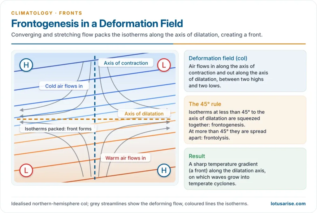
- Deformation field: a flow pattern, typically a col between two highs and two lows, in which air flows in along one axis and out along the axis at right angles to it:
- Axis of contraction (inflow): the air streams approach each other along it.
- Axis of dilatation (outflow, stretching): the air is drawn out along it.
- The 45° rule: the result depends on the angle between the isotherms and the axis of dilatation:
- Angle less than 45°: the inflow packs the isotherms together along the dilatation axis, so the gradient tightens and a front forms there (frontogenesis).
- Angle more than 45°: the flow spreads the isotherms apart (frontolysis).
- Other contributors: convergence across the isotherms tightens the gradient; tilting of the gradient by uneven vertical motion and uneven heating, such as cloud over one air mass and sunshine over the other, can strengthen or weaken it. Pure rotation (shear) only turns the isotherms without changing the gradient.
- Link with cyclones: along the polar front, the dilatation axis of the deformation field between the subtropical highs and subpolar lows is where the polar front is created and sharpened. The stretched, sharpened front then becomes unstable to the waves that grow into temperate cyclones.
How Frontogenesis Causes Weather Instability
- Forced ascent: convergence lifts warm, moist air over the cold wedge, releasing latent heat and turning conditionally unstable air absolutely unstable, with cumulonimbus, squall lines and thunderstorms.
- A secondary vertical circulation: a sharpening front drives rising air on its warm side and sinking air on its cold side, which concentrates cloud and precipitation into frontal rain bands.
- Steep gradients: concentrated pressure and temperature gradients bring strong winds, abrupt wind shifts and sudden temperature drops.
- Cyclogenesis: waves on the front deepen into frontal cyclones, the main source of the stormy, changeable weather of the middle latitudes.
- Indian example: in the hot season, dry north-westerly air meets moist air from the Bay of Bengal along a moisture front over east India; lifting along it releases the instability of the moist air as the violent Nor’westers (Kalbaisakhi) of Bengal, Odisha and Assam.
Types of Fronts
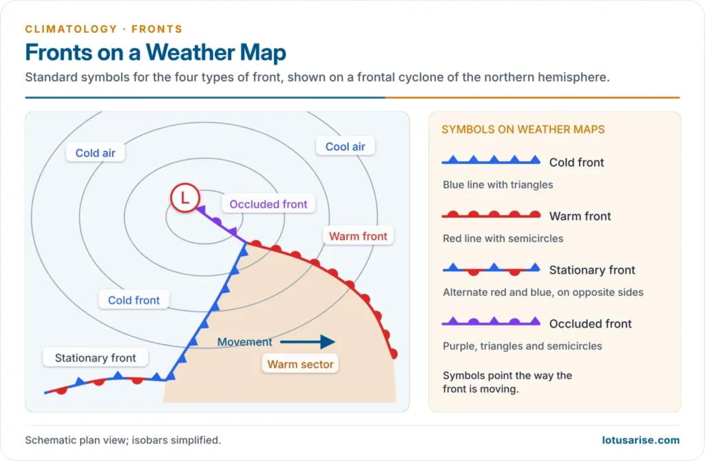
- Fronts are named by which air mass is advancing; it is the aggressor air mass that largely sets the weather.
Cold Front
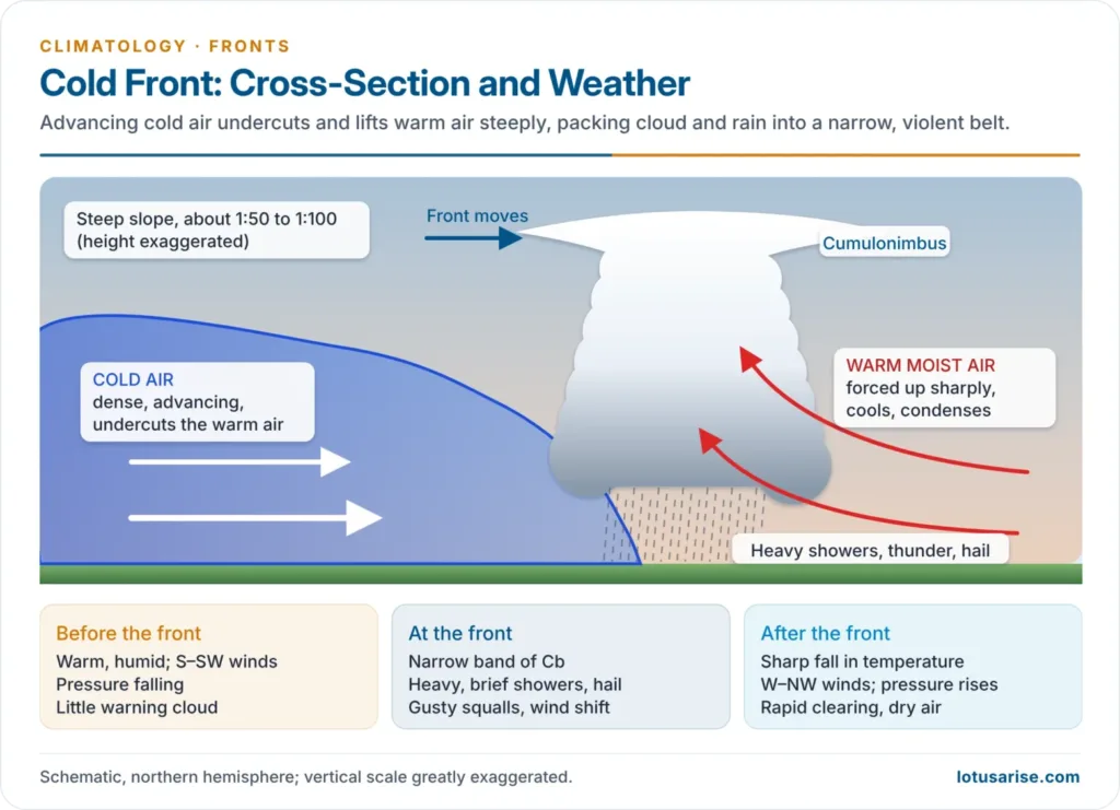
- Cold air advances and undercuts warm air, lifting it sharply.
- Slope: steep, about 1:50 to 1:100, because friction slows the surface air while the cold air above keeps moving, so the front’s nose steepens and bulges.
- Speed: cold fronts travel up to twice as fast as warm fronts.
- Weather:
- There is little advance warning: the front slopes backward, so few clouds appear ahead of it.
- A narrow band of towering cumulonimbus gives heavy showers, thunder and hail, and sometimes tornadoes in the warm air ahead.
- Over rough ground, the cold air aloft can run ahead of the surface front and set off a squall line of thunderstorms ahead of it.
- After passage: a sharp temperature drop, rising pressure, a wind shift from south or south-west to west or north-west, falling humidity and rapid clearing. In winter, a cold wave may follow.
Warm Front
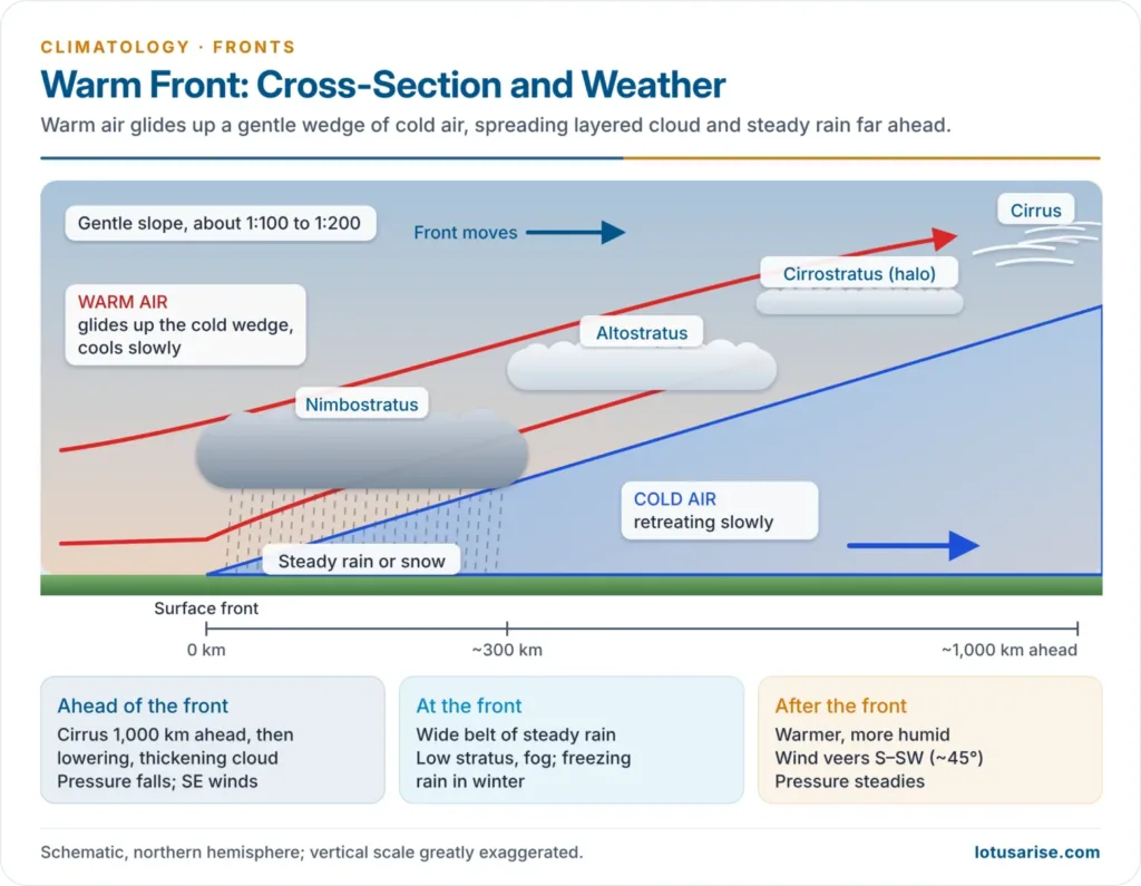
- Warm air advances and glides up over a retreating wedge of cold air (overrunning).
- Slope: gentle, about 1:100 to 1:200, since friction holds back the retreating cold air at the surface.
- Cloud sequence: cirrus appears 1,000 km or more ahead of the surface front, followed by cirrostratus (with a halo round the sun or moon), altostratus, and then nimbostratus and stratus about 300 km ahead, where steady precipitation begins.
- Unstable warm air gives a mackerel sky of cirrocumulus, and occasionally embedded thunderstorms in summer.
- Weather:
- Light to moderate, steady rain or snow over a wide belt lasting many hours.
- Rain evaporating into the cold air below gives low stratus and fog, with poor visibility.
- In winter, rain falling through sub-freezing air near the ground gives freezing rain and sleet.
- After passage: temperature and humidity rise, the pressure fall stops, and the wind shifts gradually, by about 45°, from south-east to south or south-west.
Stationary Front
- The boundary does not move, because the winds on both sides blow parallel to the front and neither air mass advances.
- Weather: warm air overrunning the cold side gives warm-front-type cloud and steady precipitation; because the front stays put for days, rain can cause flooding.
- It turns into a cold or warm front as soon as one air mass starts to advance, and is often the starting point of a frontal wave.
Occluded Front
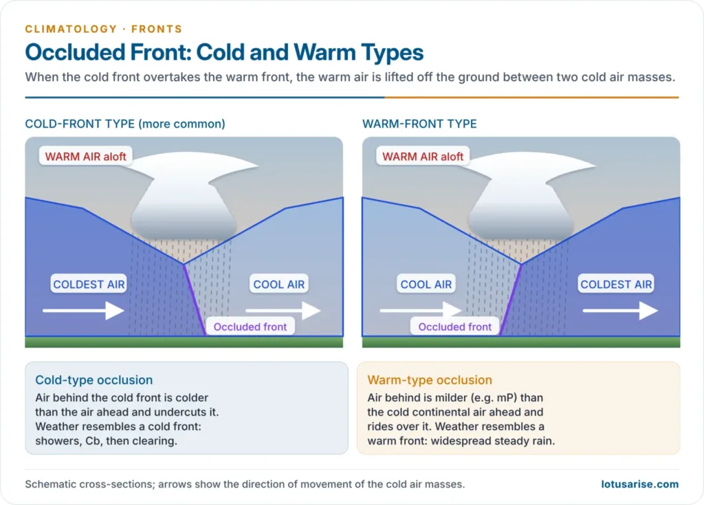
- An occluded front forms when the faster cold front overtakes the warm front and lifts the warm air off the ground; the warm sector survives only aloft.
- Cold-front-type occlusion: the air behind the cold front is colder than the cool air ahead; it undercuts that air. This is the common type, and its weather resembles that of a cold front.
- Warm-front-type occlusion: the overtaking air is less cold than the air ahead (for example, mild mP air reaching a continent chilled by radiation); it rides up over that air, and the weather resembles a warm front’s.
- Weather: complex, a mix of warm-front and cold-front weather, with the heaviest precipitation where the warm air is lifted. Occluded fronts are common over western Europe and the west coast of North America.
Comparison of Fronts
| Feature | Cold front | Warm front | Stationary front | Occluded front |
|---|---|---|---|---|
| Advancing air | Cold | Warm | Neither | Cold overtakes warm front |
| Slope | Steep (1:50–1:100) | Gentle (1:100–1:200) | Variable | Two cold masses, warm air aloft |
| Main clouds | Cumulonimbus | Ci → Cs → As → Ns | Stratiform | Mixed |
| Precipitation | Heavy, short, narrow belt | Light–moderate, steady, wide belt | Prolonged, may flood | Variable |
| After passage | Colder, clearer, pressure rises | Warmer, more humid | Little change | Cooler, clearing |
Drylines
- A dryline separates air masses that differ mainly in moisture, not temperature: dense dry air lifts the moister air like a cold front.
- The classic case lies over the US southern Great Plains in spring, between dry cT air from the south-west and moist mT air from the Gulf of Mexico, and triggers severe thunderstorms and tornadoes.
Principal Frontal Zones
- Fronts form where source regions of contrasting air masses lie close together, so the main zones are boundaries between the major air masses; they are strongest in winter, when contrasts peak, and shift poleward in summer (by about 10° over the western oceans).
- Polar fronts:
- Atlantic polar front: between cP and mT air, from the West Indies–Portugal line in the south to the Great Lakes–Iceland line in the north; its cyclones bring rain from eastern North America across the Atlantic to north-western Europe.
- Pacific polar fronts: one off Asia and one off North America in winter, producing the winter rains of the Pacific coast from Alaska to California.
- Arctic fronts: between Arctic and mP air, in winter from Iceland to the Barents Sea, and over North America between cP and Pacific mP air; in summer along the Arctic coasts of Siberia and North America.
- Mediterranean front: in winter, between cool European cP air and warmer North African air over the Mediterranean–Caspian region. Its disturbances move east to the Middle East and reach Pakistan and north-west India as western disturbances, which bring the region its winter rain and Himalayan snow.
- Southern hemisphere: the polar front lies near 45° S in January; frontal storms circle the Antarctic all year.
Previous Year Questions
2026Examine the importance of axis of dilation of airmasses in frontogenesis and the origin of Temperate cyclones.2024Formation of temperate cyclone depends on the condition of axis of dilation. Elucidate.2020Explain the characteristic features of Frontogenesis and Frontolysis.2015Discuss as to how frontogenesis contributes to weather instability.





thank you so much…
Sir… Pls cover whole syllabus of geography optional. Ur content is good and u are doing a good job for us, as I have taken optional class in 2018 but output is equal to Zero. So i have a request to you pls guide us properly and share books specially for paper 2 , by which I could complete geography optional with the help of self study. I don’t want to attend any optional class.
hi ravi are you preparing for 2023 upsc?
A complex mechanism is explained in a very easy-to-understand manner. All my doubts are solved. Thankyou!
Thank you Bhai
no where it is written that in stationary front cummulonimbus cloud can br seen, from where you have collected it?
Yes You’re right Nimbostratus, Altostratus, Cirrostratus are possible but not cumulonimbus cloud.