

- A thunderstorm is a local storm produced by a cumulonimbus cloud and always accompanied by lightning and thunder. It usually brings gusty winds, heavy showers and sometimes hail, and an individual cell seldom lasts more than one to two hours.
- Tornadoes and waterspouts are small, violently rotating columns of air hanging from such clouds, over land and over water respectively. They are the most violent winds on Earth, though very small in extent.
- These are mesoscale and local disturbances, too small for most weather charts. They release enormous energy in minutes, which makes them hard to forecast and highly destructive.
- About 1,800–2,000 thunderstorms are in progress over the globe at any moment, and the Earth receives about 44 lightning flashes every second.
Thunderstorms

Conditions for Development
- A thunderstorm works like a heat engine: the latent heat of condensation (and of freezing) released in rising moist air is turned into the kinetic energy of updrafts.
- Moisture: warm, humid air in the lower atmosphere supplies the latent heat.
- Instability:
- A steep lapse rate makes the air conditionally or convectively unstable, so a lifted parcel stays warmer than its surroundings and keeps rising.
- Meteorologists measure this as CAPE (convective available potential energy).
- Lifting (trigger):
- Something must start the air rising: surface heating (convection), mountain slopes (orographic lift), fronts, sea-breeze fronts, or the outflow of earlier storms.
- Cloud depth:
- The cloud must grow well above the freezing level, so that ice crystals, supercooled droplets and graupel coexist.
- This mixture is needed for heavy rain and for separating electric charge.
- Vertical wind shear:
- Shear decides how the storm is organised.
- Weak shear gives short-lived single cells, and strong shear gives long-lived multicells and supercells.
- Anything that suppresses convection blocks thunderstorms: an upper-air inversion, sinking air in subtropical highs, or cold ocean currents.
Life Cycle: Byers and Braham Stages
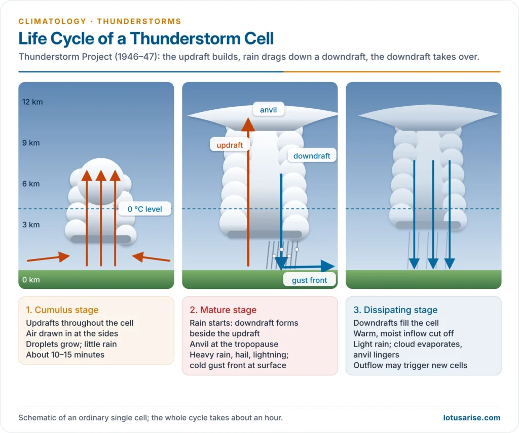
- The Thunderstorm Project (Florida 1946, Ohio 1947), led by Horace R. Byers and Roscoe R. Braham Jr., flew aircraft through storms and published the classic three-stage model in The Thunderstorm (1949).
- A thunderstorm is built of one or more convective cells, and each cell passes through three stages:
- Cumulus (developing) stage:
- The cell has updrafts throughout as a cumulus grows into cumulus congestus.
- Inflowing air is drawn in from the sides, and cloud droplets grow, but little rain reaches the ground.
- The stage lasts about 10–15 minutes.
- Mature stage:
- It begins when precipitation starts falling and its drag, together with evaporative cooling, creates a downdraft beside the updraft.
- The cloud reaches the tropopause and spreads into an anvil.
- Heavy rain, hail, lightning, thunder and strong gusts peak in this stage.
- The cold downdraft spreads out at the ground as a gust front, which brings a sudden drop in temperature and a squall.
- It is the most dangerous stage, including for aircraft.
- Dissipating stage:
- Downdrafts take over the whole cell and cut off the supply of warm, moist air.
- Rain becomes light, and the cloud evaporates, leaving the anvil behind.
- The cooling outflow often triggers new cells nearby.
Structure of a Mature Thunderstorm
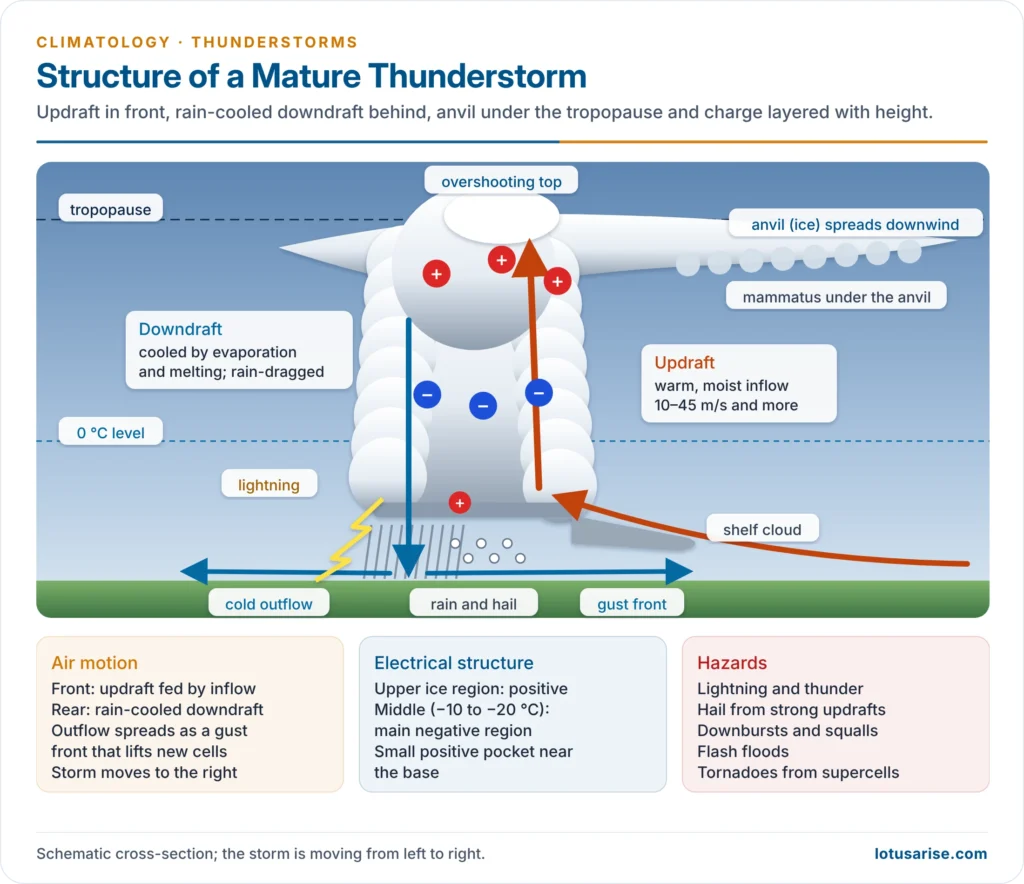
- Updraft:
- A tower of rising warm, moist air, at 10–30 m/s in ordinary storms and over 45 m/s in severe ones.
- It can lift the cloud top to 12–18 km in the tropics.
- Overshooting top: a dome above the anvil, which marks a very strong updraft.
- Anvil:
- A flat ice-crystal top spread out under the tropopause, where the rising air loses its buoyancy.
- It stretches downwind in the direction of storm motion.
- Mammatus: pouch-like clouds hanging under the anvil.
- Downdraft:
- Air cooled by evaporation and melting of rain and hail, and dragged down by the falling precipitation.
- Intense, small-scale downdrafts called downbursts (microbursts) were identified by Tetsuya Theodore Fujita in the 1970s. They are a major aviation hazard.
- Gust front:
- The leading edge of the cold outflow, often marked by a shelf or roll cloud.
- It lifts warm air ahead of it and seeds new cells.
- Electrical structure:
- The cloud has positive charge in the upper (icy) part, a main negative region in the middle (around −10 to −20 °C), and often a small positive pocket near the base.
Types of Thunderstorms
By Organisation
| Type | Structure | Life and severity | Example |
|---|---|---|---|
| Single-cell (ordinary, air-mass) | One updraft–downdraft cell, weak shear | 30–60 minutes; brief heavy shower, rarely severe | Summer afternoon storms in the tropics |
| Multicell cluster | Cells at different stages; new cells form on the gust front | Several hours; moderate hail, flash floods | Pre-monsoon storm clusters over north-east India |
| Squall line (multicell line) | A line of cells, often 100s of km long, along or ahead of a cold front | Several hours; damaging straight-line winds, shelf cloud; long-lived lines become derechos | Nor’wester lines over Bengal and Bangladesh |
| Supercell | A single giant cell with a rotating updraft (mesocyclone) in strong shear | Hours; giant hail, violent tornadoes | US Great Plains, Bangladesh |
By Origin
- Air-mass thunderstorms form within a single air mass, away from fronts:
- Local heat (convective) storms:
- These are caused by intense surface heating and peak in the afternoon over land and at night over the sea.
- They are most common in the equatorial belt all year, and rare beyond 45° latitude.
- Examples are the 4 o’clock rains of the equatorial lowlands and pre-monsoon storms over Kerala.
- Orographic storms:
- These form where moist air is forced up mountain slopes.
- They are larger and more persistent than heat storms and often stationary, as over the Western Ghats, the Himalayan foothills and the Shillong plateau.
- Advective storms:
- These form where warm air advected at low levels or cold air advected aloft steepens the lapse rate.
- Local heat (convective) storms:
- Frontal thunderstorms form where air masses meet at fronts:
- Cold-front storms:
- These are the most intense: the advancing cold wedge forces warm, moist air up steeply.
- Clearing and a drop in temperature follow quickly.
- Prefrontal squall lines form tens to hundreds of kilometres ahead of a cold front.
- Warm-front storms:
- These are weaker, form high above the ground, and are embedded in the warm-front cloud.
- Cold-front storms:
Lightning and Thunder
- Charge separation:
- The leading view, worked out in laboratory experiments by Tsutomu Takahashi (1978), is collisions between graupel (soft hail) and ice crystals in the presence of supercooled water.
- In the cold middle cloud, graupel takes negative charge and falls, while the light ice crystals take positive charge and are carried up to the anvil.
- Breaking raindrops and freezing add smaller amounts of charge.
- Discharge:
- Lightning is a giant spark that equalises charge within a cloud (most flashes), between clouds, or between cloud and ground (about a quarter of flashes).
- A cloud-to-ground flash begins with a stepped leader from the cloud, met by an upward streamer, followed by a brilliant return stroke.
- Thunder:
- The lightning channel heats the air to about 30,000 °C in microseconds.
- The air expands explosively, and the pressure wave is heard as thunder.
- Sound travels at about 340 m/s, so a 3-second gap between flash and thunder means about 1 km.
- Thunder is usually audible up to 15–25 km.
- Global hotspots:
- The highest flash density on Earth is over Lake Maracaibo, Venezuela, followed by the Congo basin.
- In India, lightning is most frequent over the north-east, West Bengal, Odisha, Jharkhand and Bihar, and over Kerala.
- Climate change: David Romps and colleagues (2014) projected about 12% more lightning for every 1 °C of warming over the United States.
Hail
- Hailstones grow when strong updrafts carry ice embryos repeatedly through layers of supercooled water. Each pass adds a layer of clear or opaque ice, until the stone is too heavy for the updraft to hold.
- Hail needs strong updrafts, a high water content and a low freezing level.
- Hail is rare in the humid tropics despite frequent storms, because the freezing level is high and stones melt on the way down. It is common in continental mid-latitudes and highlands.
- The heaviest hailstone on record weighed 1.02 kg and fell at Gopalganj, Bangladesh (1986).
- In India, February–April hailstorms regularly damage rabi crops in Maharashtra, Madhya Pradesh, Punjab and Haryana.
Distribution of Thunderstorms
- Most frequent in the humid tropics, where heat, moisture and light winds combine. Parts of equatorial Africa, Indonesia (Java) and Central America have over 150–200 thunderstorm days a year.
- Few in the subtropical deserts and west coasts (California, Chile, south-west Africa), which have subsiding air and cold currents, and rare poleward of 60°.
- In monsoon lands, storms cluster before and after the rainy season.
Thunderstorms in India
- Nor’westers (Kalbaisakhi):
- These are violent evening squall-line storms of the pre-monsoon season (March–May) over West Bengal, Odisha, Jharkhand, Assam (Bordoisila) and Bangladesh.
- Dry westerly air aloft overrides moist air from the Bay of Bengal, creating extreme instability.
- They bring useful rain for tea, jute and rice, along with hail and destructive squalls.
- Andhi:
- Dust storms of the hot season in Rajasthan, Punjab, Haryana and western Uttar Pradesh.
- The 2–3 May 2018 dust storms and thunderstorms killed more than 100 people, mainly in Rajasthan and Uttar Pradesh. A western disturbance over a superheated surface met moist easterlies from the Bay.
- Mango showers and blossom showers:
- These are pre-monsoon thunderstorms over Kerala and Karnataka that help ripen mangoes and bring coffee into flower.
- Lightning deaths:
- Lightning is India’s deadliest natural hazard in most years.
- NCRB recorded about 2,887 lightning deaths in 2022, about 36% of deaths due to forces of nature, led by Madhya Pradesh, Bihar, Odisha, Uttar Pradesh and Jharkhand.
- IMD counted about 1,300 lightning and thunderstorm deaths in 2024, with Bihar the worst-hit state.
- Most victims are farmers and labourers in open fields.
- Response:
- Lightning early-warning apps such as Damini, from the Indian Institute of Tropical Meteorology, give alerts.
- Nowcasts come from IMD’s radars, and lightning conductors protect buildings.
- Several states, such as Odisha and Bihar, run lightning action plans and awareness drives.
Tornadoes, Waterspouts and Dust Devils
Tornadoes
- Definition:
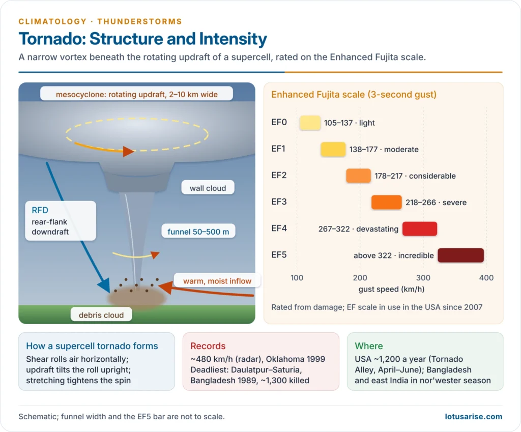
- A tornado is a violently rotating column of air extending from the base of a cumulonimbus to the ground.
- It is usually seen as a funnel cloud of condensed moisture, with a swirling debris cloud at its foot.
- The name comes from the Spanish tronada (thunderstorm).
- Dimensions:
- Usually 50–500 m wide, though a few exceed 2 km.
- They travel at 30–70 km/h along paths a few to tens of kilometres long, and usually last minutes.
- Intensity:
- Pressure in the core may fall about 100 hPa below that outside.
- Winds can reach about 480 km/h, the highest measured by mobile radar, at Oklahoma in 1999.
- Most damage comes from wind and flying debris. The old idea that buildings “explode” from the pressure drop is no longer accepted.
- Formation (supercell tornadoes):
- Vertical wind shear sets the low-level air rolling about a horizontal axis.
- A strong updraft tilts this roll upright, creating a rotating updraft, the mesocyclone, 2–10 km wide.
- The rotation is stretched and narrowed, and a rear-flank downdraft wraps around it, concentrating the spin into a tornado beneath a wall cloud.
- The ingredients are warm, moist air at the surface, dry air aloft above an inversion (a “lid”), strong shear and a lifting trigger such as a cold front or dryline.
- Non-supercell tornadoes (landspouts) are weaker and form along gust fronts and boundaries.
- Distribution:
- They occur on every continent except Antarctica.
- The United States has about 1,200 a year, the most in the world, concentrated in “Tornado Alley” (Texas–Oklahoma–Kansas–Nebraska) in April–June. There, cold, dry air from Canada, warm, moist air from the Gulf of Mexico and dry air off the Rockies meet over flat plains.
- Other tornado regions are Bangladesh and eastern India, Argentina, Europe, South Africa and Australia.
- Indian subcontinent:
- Tornadoes form in the nor’wester season.
- The Daulatpur–Saturia tornado in Bangladesh (26 April 1989) killed about 1,300 people, the deadliest on record.
- The Jalpaiguri (West Bengal) tornado of 31 March 2024 killed 5 and injured over 100.
- Forecasting: Doppler radar detects the mesocyclone and the debris signature, giving warnings tens of minutes ahead.
The Enhanced Fujita Scale
- Tetsuya Theodore Fujita (1971) devised the Fujita (F) scale to rate tornadoes from the damage they cause.
- The Enhanced Fujita (EF) scale, used in the United States since 2007, recalibrates the scale against engineering studies of 28 types of structure, using 3-second gusts:
| EF rating | Gust (km/h) | Damage |
|---|---|---|
| EF0 | 105–137 | Light: branches broken, shingles torn |
| EF1 | 138–177 | Moderate: roofs stripped, mobile homes overturned |
| EF2 | 178–217 | Considerable: roofs torn off, large trees uprooted |
| EF3 | 218–266 | Severe: walls of houses collapse |
| EF4 | 267–322 | Devastating: well-built houses levelled |
| EF5 | above 322 | Incredible: houses swept away, steel-concrete structures badly damaged |
Tornado and Tropical Cyclone Compared
| Basis | Tornado | Tropical cyclone |
|---|---|---|
| Size | 50 m – 2 km | 150–1,000 km |
| Life | Minutes to an hour | About a week |
| Origin | Supercell thunderstorm, over land | Warm ocean, latent heat |
| Winds | Up to about 480 km/h | Up to about 345 km/h |
| Rotation | Mostly cyclonic | Always cyclonic |
| Warning | Minutes | Days |
Waterspouts
- A waterspout is a rotating column of air over water, made visible by condensation and spray. It is most common over warm tropical and subtropical seas, such as the Florida Keys and the Mediterranean.
- There are two types:
- Tornadic waterspouts:
- These are true tornadoes that form over water, or move onto it, from supercells. They are rare and dangerous.
- Fair-weather waterspouts:
- These are far more common.
- They form in light winds beneath growing cumulus. Rotation builds upward from the water surface, and the spout is not tied to a severe storm.
- Their winds are weaker, mostly under 100 km/h.
- Tornadic waterspouts:
- Waterspouts are less intense than land tornadoes and threaten small boats, but they can come ashore.
Dust Devils
- A dust devil is a small, short-lived whirl of rising air made visible by dust. It forms on hot, sunny, calm afternoons over superheated dry ground, as in the Thar desert.
- Unlike tornadoes, a dust devil is not attached to a cloud. It is driven by surface heating alone and rotates either way.
Previous Year Questions
2026Describe the general characteristics and structure of a thunderstorm and suggest suitable classification of thunderstorm.2021Indicating the causes of lightning, describe the threats associated with it.2018Explain the unusual intensity of dust storms and thunderstorms across India in the pre-monsoon period of the year 2018.2014Describe the origin and development of thunderstorms with examples.




