

- Geography is the study of the earth’s surface as the home of humankind: where things are, why they are there, how they are linked, and how people and environment shape each other.
- Its definition has changed with each period of thought. It has been described in turn as earth description, the study of the earth as the home of man, of man–environment relations, of areal differentiation, and of spatial organisation.
- The discipline studies both nature and society. That double field makes it a bridge between the natural and social sciences and gives it its integrating, place-centred character.
Meaning of Geography

Etymology and Origin of the Word
- The word comes from the Greek ge (earth) and graphein (to write or describe): literally “earth description”.
- Eratosthenes of Cyrene (c. 276–194 BCE), librarian at Alexandria, is credited with first using geographia as the title of a work. His measurement of the earth’s circumference was a landmark of the Greek contribution.
- The Indian term Bhugol (bhu, earth, and gol, sphere) carries the idea of a spherical earth, reflecting the astronomical tradition of the Surya Siddhanta and Aryabhata (geographical thought in India).
- Two parts of the word:
- The geo part points to the zone where lithosphere, atmosphere, hydrosphere and biosphere meet.
- The graphy part points to describing and explaining what is found there in terms of place, location and distribution.
The Earth’s Surface as Geography’s Field
- The “earth surface” of geography is not a mathematical plane. It is a thin shell, roughly a thousandth of the planet’s circumference in depth, reaching as far below and above ground as human activity normally goes.
- Its thickness grows with technology: deep mines and boreholes below, aviation and satellites above.
- A late-19th-century debate tested the limits of the field:
- Ferdinand von Richthofen, in his Leipzig inaugural lecture (1883), made the earth’s surface (Erdoberfläche) the object of geography. He studied its forms in relation to the processes and phenomena connected with them.
- Georg Gerland (1887) went further and treated geography as the science of the whole earth, close to geophysics, leaving people largely to other sciences.
- Alfred Hettner (1905 onwards) answered that geography is defined not by a kind of object but by a point of view: the chorological, place-by-place study of what coexists on the earth’s surface. Gerland’s view did not prevail, and geophysics became a separate science.
- Gerland’s reasoning was that the earth is one celestial body among many. It deserves a science of its own because it alone, as far as we know, carries life, within a narrow range of temperature. Geographers study mainly its surface only because the interior is hard to observe.
- Both physical and human phenomena have a definite place, localisation and distribution on this surface. Their combination and interaction form the core and raison d’être of geography.
- There can be no geography without both. Without geography, knowledge of the earth stays fragmented among separate sciences.
Space and Time in the Meaning of Geography
- The simple question “Where do people live?” contains the whole subject.
- Where refers to place and location on the earth’s surface.
- Live refers to the distribution and concentration of people and their ways of life.
- Time is built into it. The earth-bound phenomena keep changing:
- Natural events such as floods, cyclones and earthquakes strike a particular place at a particular time.
- People modify the face of the earth in ways that belong to a period, a technology and a way of life. The canal colonies of Punjab and the planned towns of the Indus valley are each products of their time.
- Geography therefore describes the earth’s surface as it is now, but explains it as the outcome of processes working through time.
The Core Questions
- Where is it? Location, both absolute (latitude and longitude) and relative (accessibility to other places).
- What is it like? Description of the phenomena found there. Every description is selective, shaped by the observer’s concepts as well as by direct observation (percept and concept).
- Why is it there, and what does it mean? Explanation through cause and process, and the significance of the pattern for people.
- How are places linked, and how do they change? Interaction between places, and change through time.
- Teaching frameworks condense these into themes:
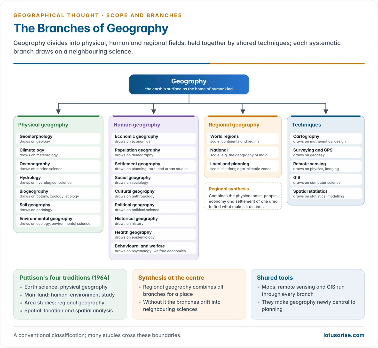
- William Pattison’s four traditions (1964): spatial, area studies, man–land, and earth science.
- The American five themes (1984): location, place, human–environment interaction, movement and region.
Definitions of Geography through the Ages
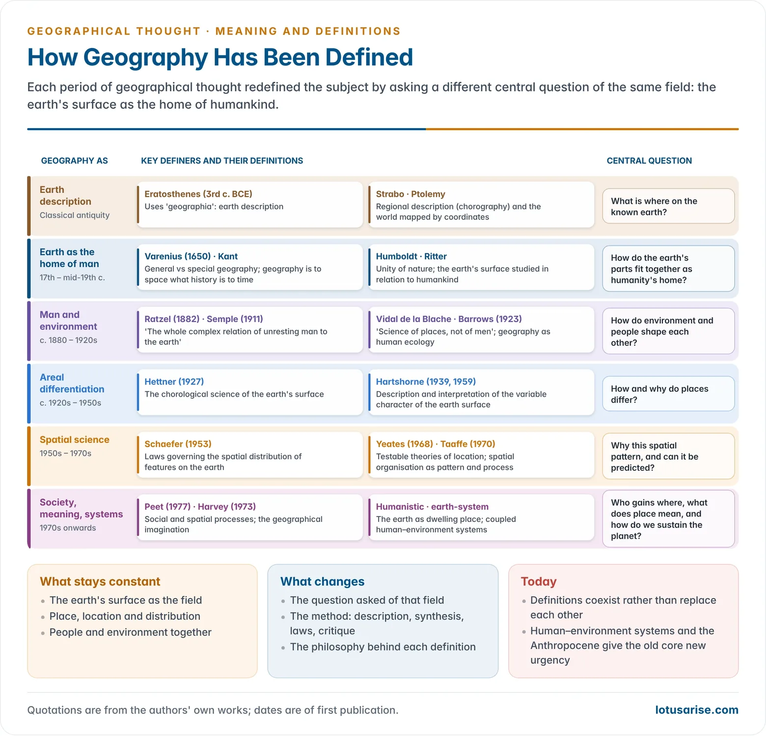
Geography as Earth Description
- Classical period: geography meant describing the known world and fixing its places.
- Strabo’s Geographica gave regional description (chorography).
- Claudius Ptolemy’s Geographike Hyphegesis (c. 150 CE) treated geography as mapping the whole known world by latitude and longitude, as distinct from the detailed description of small areas.
- Bernhard Varenius (Geographia Generalis, 1650) divided the subject into general geography (laws of the whole earth) and special geography (description of particular countries).
- Immanuel Kant, lecturing at Königsberg from 1756, made physical description of the earth an empirical foundation for all other knowledge. The work of Varenius and Kant gave the subject its philosophical base.
Geography as the Study of the Earth as the Home of Man
- Carl Ritter defined the field as the earth’s surface studied in relation to humankind: the earth as the home (dwelling place) of man. History and geography, he held, are inseparable.
- Alexander von Humboldt treated the earth as a unity of interconnected phenomena, people included.
- Together, Humboldt and Ritter made geography an integrating science.
Geography as the Study of Man–Environment Relationships
- Friedrich Ratzel (Anthropogeographie, 1882, 1891) made human geography a systematic study of how environments shape peoples and their spread over the earth.
- Ellen Churchill Semple (1911): “The whole complex relation of unresting man to the earth is the subject matter of anthropo-geography.”
- Paul Vidal de la Blache called geography “the science of places, not of men”. He meant that it studies people through the places and ways of life (genres de vie) they create.
- Harlan H. Barrows (1923) defined geography as human ecology, the study of human adjustment to natural environments.
- The changing balance between nature and human choice produced the environmentalism debate: determinism, possibilism and neo-determinism.
- A two-way relation:
- Climate, relief, soils and resources shape how societies live, what they grow and where they settle.
- Societies in turn modify, use and adapt to their surroundings through technology and culture, with both beneficial and harmful results.
- India offers many examples: terraced fields and transhumance in the Himalaya, rainwater harvesting in kunds and johads in the Thar, and the monsoon-timed cropping calendar of the plains.
- This relation is the basis of geography’s contribution to today’s problems: climate change, land degradation and sustainable development.
- The historian of ideas Clarence Glacken traced three older Western views: humans in harmony with nature, humans dominated by nature, and humans dominating nature.
Geography as Areal Differentiation and Chorology
- Alfred Hettner (1927) defined geography as the chorological science of the earth’s surface. It is concerned with how things differ from place to place and how they coexist and interact in places, as history is concerned with time.
- Richard Hartshorne gave the best-known statements:
- In The Nature of Geography (1939), geography aims to “describe and interpret the variable character from place to place of the earth as the world of man”.
- In Perspective on the Nature of Geography (1959), it is “concerned to provide accurate, orderly, and rational description and interpretation of the variable character of the earth surface”.
- Jan Broek (1965) wrote that geography seeks to understand the earth as the world of man, with reference to the differentiation and integration of places.
- This view underpins areal differentiation and the regional concept.
Geography as Spatial Science and Spatial Organisation
- Fred K. Schaefer (1953) criticised Hartshorne’s position as exceptionalism. He defined geography as “the science concerned with the formulation of the laws governing the spatial distribution of certain features on the surface of the earth”.
- A 1965 US National Academy of Sciences report, chaired by Edward Ackerman, described geography as the study of spatial distributions and space relations on the earth’s surface.
- Maurice Yeates (1968) called it a science concerned with developing and testing theories that explain and predict spatial distribution and location.
- Edward Taaffe (1970) defined it as the study of spatial organisation expressed as patterns and processes.
- These definitions came with the quantitative revolution. Location models such as those of Johann Heinrich von Thünen (1826), Walter Christaller (1933) and August Lösch (1940) became central.
Later Definitions
- Radical: Richard Peet (1977) defined Marxist geography as the study of the relation between social processes and spatial processes. David Harvey’s “geographical imagination” (Social Justice and the City, 1973) is the ability to see how space and place shape one’s own life and society.
- Humanistic: geography as the study of the earth as the dwelling place of humankind, centred on place, meaning and experience.
- Integrative and present-day: Peter Haggett described it as the study of the earth’s surface as the space within which the human population lives. Current work frames it around coupled human–environment systems, sustainability and the Anthropocene.
| Phase | Geography defined as | Key proponents |
|---|---|---|
| Classical | Description and mapping of the known earth | Eratosthenes, Strabo, Ptolemy |
| 17th–19th century | Earth as the home of man; unity of nature | Varenius, Kant, Humboldt, Ritter |
| c. 1880–1920s | Man–environment relationship | Ratzel, Semple, Vidal de la Blache, Barrows |
| c. 1920s–1950s | Areal differentiation; chorology | Hettner, Hartshorne, Broek |
| 1950s–1970s | Spatial science; spatial organisation | Schaefer, Yeates, Taaffe, Haggett |
| 1970s onwards | Social, radical, humanistic, earth-system | Peet, Harvey, Tuan, Haggett |
Distribution as a Geographical Theme
- A spatial distribution is a set of similar objects spread over the earth’s surface. It has three independent components:
- pattern: the geometric arrangement;
- density: the number per unit area;
- dispersion: how far apart the objects lie.
- For example, a map of India’s 53 million-plus urban agglomerations (Census 2011) has a pattern, a density and a degree of dispersion that can each be compared with other maps.
- Distribution in each branch:
- Physical geography studies the distribution of landforms, climates, vegetation and soils and the processes behind them, such as plate tectonics, atmospheric circulation and erosion.
- Human geography studies the distribution of population, migration, settlements and economic activity and the social, economic and political forces behind them.
- Environmental geography studies the distribution of pollution, biodiversity and resources and the causes and consequences of their patterns.
- Roots and tools:
- Humboldt’s geography of plants, which related plant distribution to altitude and climate, founded distribution studies and modern biogeography.
- Today cartography and GIS map distributions from local to global scale: biodiversity hotspots, land-use change, and the spread of earthquake and tsunami hazards.
- Location theory explained economic distributions:
- Von Thünen’s rings of land use around a market city were ordered by perishability and transport cost.
- Christaller’s central places formed a hierarchy, with larger centres offering more specialised goods and services.
- Lösch derived ideal market areas and a regular economic landscape.
- Kinds of distribution:
- Continuous distributions exist at every point: elevation, temperature, pressure.
- Discrete distributions are broken by areas of absence: a crop in a district, or towns.
- Areal association: when the highs and lows of two distributions coincide in an area, they are areally associated, and one may help to explain the other.
- Hettner’s caution: the distribution of one kind of thing, for instance a family of animals, belongs to the systematic science that studies it. Geography’s concern is how different things combine in places, so “where” is necessary to geography but not sufficient.
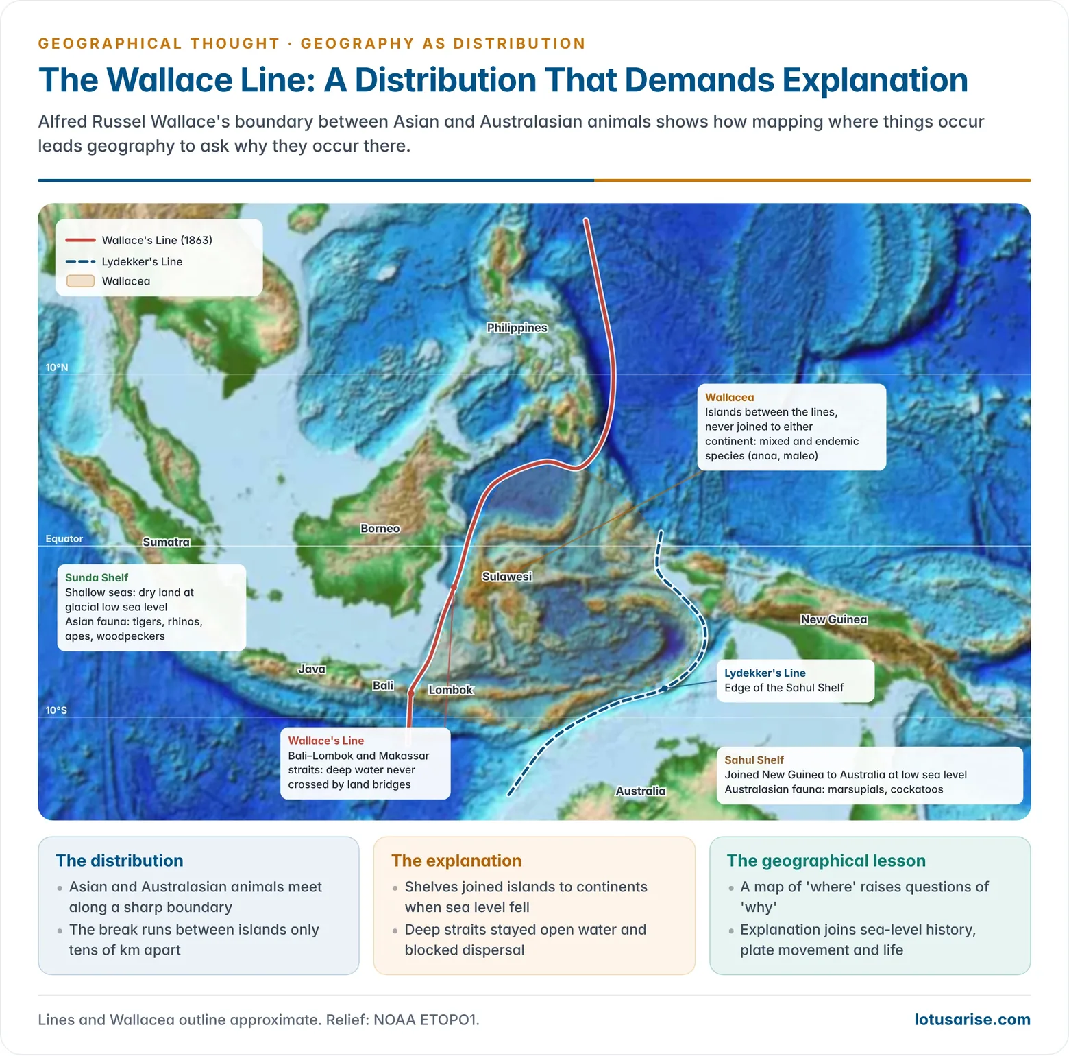
- A classic example: Alfred Russel Wallace found a sharp break between Asian and Australasian animals across a narrow strait between Bali and Lombok. The boundary, now the Wallace Line, follows the edge of the old continental shelves. It shows how a distribution map raises geographical questions of cause: sea-level history, plate movement and barriers to dispersal.
Nature of Geography
Geography’s Place among the Sciences
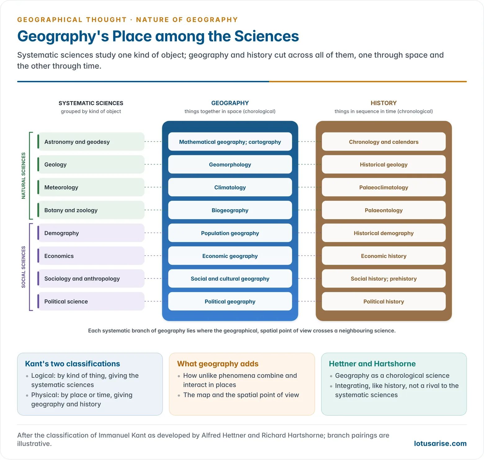
- Kant’s two classifications of knowledge:
- Logical classification groups things by kind. This gives the systematic sciences: geology, botany, economics and so on.
- Physical classification groups things by when or where they occur. History studies things in time and geography in space. Together they “fill up the entire circumference of our perception”.
- History is narrative; geography is description and interpretation.
- Hettner and Hartshorne built on this. Geography is a chorological science that cuts across the systematic sciences, as history does.
- Each systematic branch of geography sits where geography crosses a neighbouring science: climatology with meteorology, soil geography with soil science, economic geography with economics.
- Integrating, not merely borrowing:
- Geography takes generic concepts from the systematic sciences, but its task is to show how heterogeneous phenomena are causally interrelated in areas.
- It returns to those sciences the geographic aspect they overlook, and the tools of maps and spatial analysis.
- Where is the core? If a geologist, botanist, economist and sociologist each wrote one chapter on a region, the interaction between their subjects would be missing. That interaction is geography’s own field.
- Nevin Fenneman (1919) therefore saw regional geography as the core that keeps the subject from being absorbed by its neighbours.
- Two especially close neighbours:
- History: “there is no history without geography”. Every event happens at a place, and interpreting present landscapes needs their past. To study the Mughal or colonial period in India is to join time and space. History can be a means to a geographical end, and geography a means to a historical one.
- Geology: landforms are the expression of structure, process and stage. Geology supplies the structure, and geography studies how process and time shape the surface. Their meeting ground is geomorphology.
- A “mother” discipline: geodesy, meteorology, oceanography, soil science, ecology and regional science all grew out of older geography.
A Discipline of Synthesis
- Synthesis has always been geography’s purpose and justification. It brings together, place by place, what the systematic sciences study separately.
- The idea goes back to the unity of nature of Humboldt and Ritter, and to Ritter’s whole (Ganzheit), in which organic and inorganic, human and non-human phenomena form one interconnected complex.
- Quantitative and critical geography did not abandon synthesis. They sought it through new forms of analysis, such as systems models, GIS overlays and political economy.
- Empirical character: geography deals with observable reality, chiefly as it exists at present. Its statements must ultimately be checked against facts in the field, on maps and in data.
Science or Art?
- As a science geography observes, measures, classifies and explains. It tests hypotheses, builds models and, with remote sensing and GIS, predicts: flood extents, cyclone tracks, urban growth.
- As an art it depends on synthesis, judgement and representation: selecting what matters in a region, writing its character, and designing maps that communicate. Peter Haggett titled a book on the subject’s methods The Geographer’s Art (1990).
- Both are needed. Analysis without synthesis loses the place; description without explanation loses the science.
Natural Science or Social Science?
- Anomalous position: once knowledge was divided into sciences of nature and sciences of society in the 19th century, geography, which studies both, fitted neither neatly. University chairs came late, in the 1870s.
- Drift towards social science:
- As the specialised earth sciences took over parts of the physical field, human geography increasingly studied people in society from a spatial standpoint.
- The quantitative revolution of the 1960s linked it to economics. Behavioural and humanistic work in the 1970s linked it to psychology and the humanities. Political economy linked it to sociology.
- Space as a dimension of society: economic, political and social organisation all happen somewhere. The spatial dimension cuts across all of them, which makes geography a meeting ground of the social sciences.
- Physical geography remains a natural (earth) science. The discipline as a whole is best seen as a bridge between the two, now strengthened by work on climate, hazards and sustainability, which needs both.
Idiographic and Nomothetic
- Regional study treats places as unique (idiographic). Systematic study seeks general laws (nomothetic).
- Geography needs both. The systematic and regional approaches are now regarded as complementary, and most of the old dualisms in geography have softened.
Fundamental Concepts
| Concept | Meaning |
|---|---|
| Location | Absolute (grid) and relative (accessibility) position |
| Place | The particular character of a location, physical and human |
| Region | An area homogeneous in chosen criteria (formal) or tied to a node (functional) |
| Areal differentiation | Variation of the earth’s character from place to place |
| Spatial distribution | Pattern, density and dispersion of a phenomenon |
| Spatial interaction | Flows of people, goods, money and ideas between places |
| Areal association | Coincidence of distributions within an area |
| Scale | Results change with the size of the area studied |
| Change over time | Places as products of past processes (sequent occupance) |
| Cultural appraisal | Resources are defined by culture and technology, not by nature alone |
- Lawrence Senesh (1967) arranged these into a conceptual structure. Geographic facts in a chosen area and time form distributions. Distributions studied for similarity give uniform regions, and studied for interaction give functional regions. Together these explain areal differentiation.
Scope and Branches of Geography
Scope
- Field: everything that occurs in the geosphere, the zone of contact of land, air, water and life, so far as it varies from place to place. Its scope has a double aspect: the physical environment and human life.
- Links with other sciences: geography draws on the natural sciences and the social sciences, and each overlap has produced a systematic branch.
- Astronomy and mathematics: the earth’s shape, size, motions and grid, which gave mathematical geography and cartography.
- Physics: the mechanics of atmosphere and ocean, which gave climatology and oceanography. Physics also supplied the hypothetico-deductive method and the models of theoretical geography.
- Botany, zoology and ecology: the distribution of plants and animals and their communities, which gave biogeography. The ecosystem idea brings people, plants and animals into one system of energy and matter flows.
- Economics: the location of production, exchange and consumption, which gave economic geography and, after the 1950s, location theory and regional science.
- Sociology and anthropology: social organisation, ways of life and cultural traits in their spatial setting, which gave social and cultural geography.
- History and political science: past geographies and the territorial organisation of power, which gave historical and political geography.
- Three ways of analysing: Peter Haggett distinguished spatial analysis (location and pattern), ecological analysis (society–land relations within an area) and regional complex analysis, which combines the two for particular regions.
- Techniques: cartography, surveying, remote sensing, GIS and GPS, and statistical and computational methods now run through every branch.
- Widening scope: environmental change, disaster risk, health, gender, development, the geography of the digital economy, and planetary and space applications.
Branches
- Physical geography:
- geomorphology (landforms);
- climatology (Wladimir Köppen’s classification);
- oceanography (Matthew Fontaine Maury’s early synthesis);
- hydrology;
- biogeography (from Humboldt’s plant geography);
- soil geography (Vasily Dokuchaev);
- environmental geography.
- Human geography:
- economic (agricultural, industrial, transport, resource);
- population;
- settlement (rural and urban);
- social, cultural, political (including geopolitics and electoral geography), historical and medical geography;
- the newer behavioural, welfare and gender geographies.
- Regional geography: the synthesis of all branches for particular areas, from continents to districts.
- Geographical techniques: cartography, remote sensing, GIS, quantitative methods.
- Mathematical and astronomical geography, the oldest branches, survive as the study of the earth’s shape, motions and grid, and underpin cartography.
Aims and Purpose of Geography
- Logical and useful knowledge of the human habitat. In Preston E. James’s phrase:
- logical, so that explanations can be tested and trusted;
- useful, so that people can adjust to varied natural conditions, improve adverse ones and use resources wisely.
- Understanding how the planet works: weather and climate, the formation of landforms, the water cycle and the distribution of life. This knowledge underlies forecasting of monsoons, cyclones and floods, and the management of land and water.
- Spatial understanding: to know where things are and why. This means reading maps, judging distance and direction, and recognising patterns of location, density and spread.
- Understanding places and regions: to explain the distinct character of each place as a combination of physical and human features, and the interconnections that link places into larger systems.
- Human–environment balance: to show how societies use and alter their environments and with what consequences. This provides the knowledge base for sustainable development, conservation, and adaptation to climate change.
- Planning and policy: geography supplies the spatial dimension of decisions. Indian examples:
- the Planning Commission’s division of India into 15 agro-climatic regions (1989) for farm planning;
- PM Gati Shakti (2021), a GIS-based national master plan for infrastructure;
- SVAMITVA (2020), drone mapping of village property;
- hazard zoning and cyclone early warning, which has sharply cut deaths in Odisha’s coastal districts.
- Development and equity: to map regional disparities in income, health and education and guide where investment is most needed.
- International understanding and citizenship: knowledge of other lands and peoples builds respect for diversity and an informed view of global issues such as migration, trade, conflict and pandemics.
- Everyday use: finding one’s way with maps and satellite navigation, choosing where to live or set up a business, and understanding the news of distant places.
- Preparing for the future: to equip people to face climate change, pollution, resource scarcity and urban growth, and to work together on solutions.
- Geographical imagination: to help each person see how space and place shape their own lives.
Key Terms
| Term | Meaning |
|---|---|
| Determinism | The view that the physical environment largely controls human activities and the course of societies |
| Possibilism | The view that nature offers possibilities and people choose among them according to culture and technology |
| Neo-determinism | A middle view: nature sets limits and broad directions, humans set the pace within them (“stop-and-go”) |
| Spatial distribution | The arrangement of a phenomenon over an area, described by its pattern, density and dispersion |
| Human–environment interaction | The two-way influence between people and their natural surroundings, including resource use, pollution and adaptation |
| Areal differentiation | The variation in the character of the earth’s surface from place to place |
Previous Year Questions
- No direct PYQ has been asked on this sub-topic yet.




