

- Dualism means that one subject is held in two contrasting conceptual stances at once: two parallel views of the same field, each with its own emphasis and method.
- A dichotomy arises when such a contrast hardens into a division of the subject matter itself, so that each stance becomes a separate branch with its own practitioners.
- The two terms are often used interchangeably, but they differ: dichotomy is a dividing line in content, while dualism is a continuing debate over one subject, two parallel ideas with a common goal but distinct emphases.
- Dualism is a hallmark of social philosophy and environmental thinking. Because thinking about the human environment has itself been dualistic, a series of dualistic positions grew up in geographical learning.
- Geography has carried dualisms since its beginnings: general vs special (systematic vs regional), physical vs human, determinism vs possibilism, historical vs contemporary, formal vs functional regions, idiographic vs nomothetic and quantitative vs qualitative.
- Dualism is not peculiar to geography. Every discipline that studies both nature and society meets it, but geography, which studies both on the same earth surface, has felt it most sharply.
- Preston E. James (1954) judged that these dualities had obscured rather than illuminated the nature of the discipline, and insisted that there is “only one kind of geography”.
Meaning and Origins of Dualism

Dualism and Dichotomy Compared
| Term | Meaning | What it does to the subject | Example |
|---|---|---|---|
| Dualism | Two contrasting stances on one subject | Keeps debate alive within one discipline | Should geography seek laws or describe the unique? |
| Dichotomy | Division of subject matter into two branches | Splits the discipline into separate camps | Physical geography and human geography taught as separate fields |
- Dualism is a matter of method and outlook; dichotomy is a matter of content and organisation. The first can enrich a subject, while the second can fragment it.
Early Traces
- Greek and Roman scholars already leaned in different directions, though no one framed it as a dualism.
- Hecataeus stressed the description of the earth, while Herodotus described peoples and their surroundings and treated history and geography together.
- Strabo concentrated on regional description, while Ptolemy pursued mathematical geography.
- Hippocrates, Aristotle, and later the Arab scholars Al-Masudi, Al-Biruni, Al-Idrisi and Ibn Khaldun, interpreted the influence of the physical environment on ways of life.
- These early contrasts were vague and unformulated. Dualism became conspicuous only in post-Renaissance Europe, when a flood of new information about particular places forced scholars to ask how the particular relates to the general.
The Nineteenth-Century Crisis of Identity
- In the 19th century, knowledge was divided into natural sciences, social sciences and humanities, and the earth was parcelled out among systematic sciences such as geology, botany, meteorology and economics.
- Geography lost much of its subject matter. What remained was the earth surface as the home of man, a field needing attention to both nature and society.
- Logically it could claim to be neither a natural science nor a social science. This produced a real crisis of identity for the new university discipline.
- The crisis was answered in the 1880s in different ways, each of which planted a lasting dualism:
- Friedrich Ratzel made the man–environment relationship the core of geography.
- Ferdinand von Richthofen (inaugural address at Leipzig, 1883) and Paul Vidal de la Blache defined geography as chorology, the study of particular segments of the earth surface.
- Oscar Peschel and Georg Gerland (1887) wanted man taken out altogether, leaving geography a physical science. Otto Schlüter limited it to the visible landscape.
- Chorology had a practical push. The new German Empire after 1871 needed knowledge of lands and peoples for its colonies, and the new chairs found that both natural and social phenomena take their character from their areal context.
- Richard Hartshorne (1939) observed that for a time geography appeared split into two irreconcilable halves, one a natural science and the other a social science.
The Main Dualisms at a Glance
| Dualism | First clearly stated | First pole | Second pole | Present view |
|---|---|---|---|---|
| General vs special | Varenius, 1650 | Laws of the whole earth | Description of particular places | Complementary approaches |
| Systematic vs regional | Humboldt and Ritter, early 19th c. | One phenomenon over the earth | All phenomena in one region | Ends of a continuum |
| Physical vs human | Varenius; sharpened after Ratzel | Nature, natural-science methods | Society, probabilistic explanation | Integrated; human–environment interface |
| Determinism vs possibilism | Ratzel and Semple vs Vidal and Febvre | Nature controls | Humans choose | Neo-determinism, probabilism |
| Historical vs contemporary | Kant’s time and space | Past geographies | Present patterns | Present is the “historical present” |
| Formal vs functional regions | Mid-20th c. | Uniform areas | Nodal areas linked by flows | Both used in regionalisation |
| Idiographic vs nomothetic | Kant; Windelband (1894) | The unique | The general law | Both needed in research |
- A common sixfold list of geography’s dualisms runs: general vs special, systematic vs regional, physical vs human, determinism vs possibilism, theoretical vs applied, and idiographic vs nomothetic.
- The first four divided the subject matter itself and so produced true dichotomies.
- The last two emerged after the Second World War, more from society’s demands on geography than from any division of content.
- None of the six threatened the subject. Each prompted debate that ultimately enriched it, and much of present-day geography still advances through such dualistic debate.
From Dichotomy to Dualism: The Historical Sequence
- Stage 1, the divisions of method and content: Varenius split general from special geography. Humboldt’s systematic and Ritter’s regional approaches drew a methodological dividing line. Ratzel then drew a content line by founding human geography beside physical geography, and the French possibilists added environmentalism vs possibilism.
- By about 1900 geography thus carried three sets of dichotomies: systematic vs regional, physical vs human, and environmentalism vs possibilism. For a young discipline this was an unhealthy trend.
- Stage 2, the unitary reaction: many geographers then argued for a unitary approach that narrowed the distance between the divided parts. O. H. K. Spate, L. Dudley Stamp and Griffith Taylor welcomed debate but rejected the division of geography.
- This turned the dichotomies into dualisms: continuing arguments and counter-arguments within one discipline.
- Stage 3, theory and relevance: positivism after 1953 brought theoretical models borrowed from physics and economics, such as Weber’s location model and the gravity model. The critical revolution after 1970 pushed geography towards real-world relevance.
- Stage 4, the applied present: present-day geography gives more weight to human and applied concerns. This is less a victory of human geography than a condition of survival among applied subjects.
- Welfare-oriented planning, such as India’s Border Area Development Programme and tribal-area development programmes, uses physical and human knowledge together.
- Some traditional physical themes have been marginalised, while new concerns have entered human geography.
- Outcome: the dichotomy has lost much of its importance, but dualism keeps its place as an engine of methodological debate.
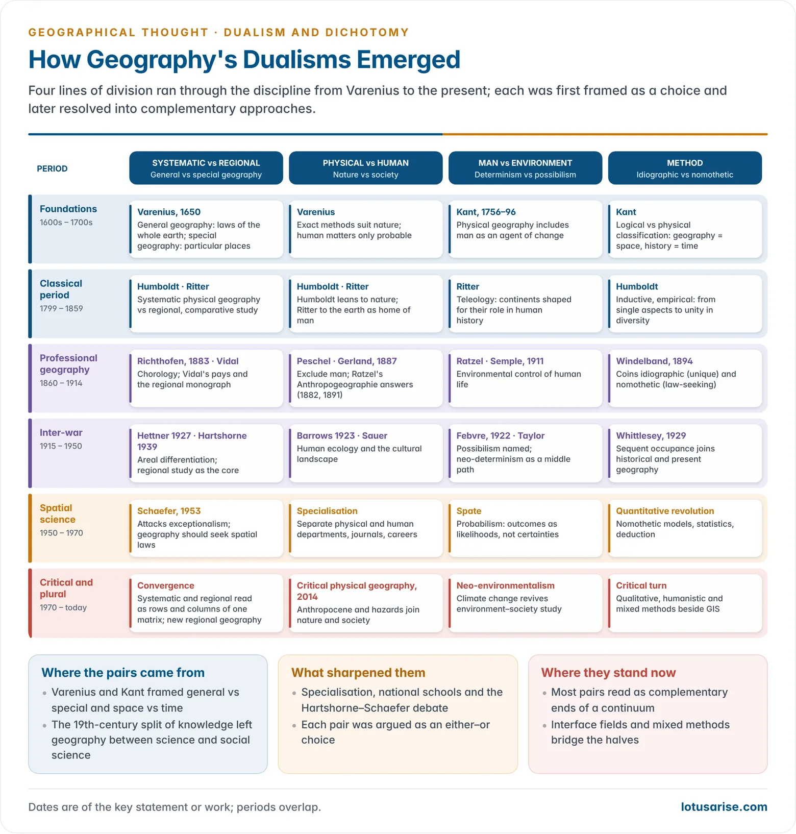
The Major Dualisms
General vs Special Geography (Systematic vs Regional)
Varenius: General and Special Geography
- The terms general and special geography were used by Bartholomäus Keckermann, who taught at Danzig in the first decade of the 1600s (Systema geographicum, published posthumously in 1612).
- Bernhard Varenius (1622–1650) gave the distinction its classic form in Geographia Generalis (1650).
- General geography treated the whole earth as a unit, in three parts: the absolute (shape, size and physical features of the earth), the relative (the earth’s relations with the sun and other bodies) and the comparative (the relative location of places and navigation).
- Its truths could be proved by mathematical and astronomical laws, so it was mainly physical.
- Special geography described particular countries and regions under celestial, terrestrial and human conditions. It rested on direct observation and served government and commerce.
- Varenius admitted the human conditions only as a concession to tradition, because they could not be treated exactly.
- He did not see the two as rivals. Special geography supplied the facts, and general geography the principles; they were interdependent parts of one whole.
- Laws were hard to establish in special geography because human behaviour is unpredictable, but special studies still helped to frame hypotheses and structured ideas.
- General geography treated the whole earth as a unit, in three parts: the absolute (shape, size and physical features of the earth), the relative (the earth’s relations with the sun and other bodies) and the comparative (the relative location of places and navigation).
- Gradually all studies of a general nature came to be called systematic geography, which drew on the systematic sciences in search of generic concepts. Special studies became regional geography, which remained within the bounds of particular places.
- In German usage, general geography came to be called allgemeine or systematische Geographie, and special geography Länderkunde. Johann Christoph Gatterer and others restated the distinction in the late 18th century.
Kant: Space, Time and Exceptionalism
- Immanuel Kant lectured on physical geography at Königsberg (1756–1796) and classified knowledge in two ways.
- Logical classification groups things by kind, giving the systematic sciences (zoology, geology).
- Physical classification groups things by where and when they occur: history reports phenomena in time, geography reports phenomena side by side in space.
- He divided geography into mathematical, moral, political, mercantile (commercial) and theological branches, around a core of physical geography that included man and his changes to the earth.
- Kant thus made geography a chorological study. Fred K. Schaefer later traced geography’s exceptionalism, the claim that it studies only the unique, back to this Kantian position.
- Later echoes of Kant:
- The Neo-Kantians of 19th-century Germany separated the cultural and historical sciences, which seek to understand the unique, from the natural sciences, which explain through laws. This is the root of the idiographic–nomothetic pair.
- Alfred Hettner built Kant’s scheme into a threefold classification: systematic sciences (by kind of object), chronological sciences (history, by time) and chorological sciences (geography and astronomy, by space).
- Torsten Hägerstrand’s contrast between compositional theory (things grouped by kind) and contextual theory (things grouped by their setting in time and space) restates the same Kantian distinction.
Humboldt and Ritter
- Alexander von Humboldt and Carl Ritter turned the general–special distinction into the systematic–regional dualism.
- Humboldt developed systematic physical geography. His method was inductive and empirical, moving from detailed observation of single aspects to the unity in diversity of nature in Kosmos (1845–62). He separated uranography (descriptive astronomy) from geography.
- He saw the cosmos as a harmonious unity in which humans are an integral part of nature, and he held that all human races share a common origin, rejecting any idea of racial superiority.
- He believed that studying particular phenomena systematically, with their distribution and causes, was more fruitful than describing whole regions in isolation.
- He insisted that facts cannot be explained in isolation. Germany’s climate, for example, cannot be explained without the circulation of Europe as a whole, which only a systematic study can supply.
- Ritter was a regional geographer and a teleologist. He studied areas “as a whole, as in parts” to grasp their place in a divine plan, and saw the earth as the home of man.
- His Erdkunde dealt with local conditions (Lokalverhältnisse) under three heads: topographical (natural divisions of the surface), formal (distribution and movement of water and air) and material (minerals, plants, animals and people).
- His method was empirical and comparative: “my system builds on facts, not on philosophical arguments”. He took the continents (Erdteile) as his major regions, each with a highland core, terraces and coastal lowlands.
- He compared regions at different levels, macro, meso and micro: the climate of Europe is a higher-order generalisation than the climate of Germany.
- He asked for a comprehensive account of every aspect of a region, from physiography, climate, soil and vegetation to population and economy. Such work remains relevant: the National Capital Region, for instance, can be studied as one entity for planning.
- His Erdkunde laid the foundation of modern regional geographical study.
- Humboldt developed systematic physical geography. His method was inductive and empirical, moving from detailed observation of single aspects to the unity in diversity of nature in Kosmos (1845–62). He separated uranography (descriptive astronomy) from geography.
- Neither man saw the approaches as exclusive.
- Humboldt compared the Russian steppes with the deserts of Central Asia, a regional exercise.
- Ritter acknowledged that Humboldt’s general studies made his own regional studies possible, and aimed to move “from mere description to the law of the thing described”.
From Richthofen to Vidal de la Blache
- Ferdinand von Richthofen sought a balance. He described the physical setting of a region first and then the adjustment of man to it, a pattern that dominated regional writing for decades.
- He called general geography analytical and special geography synthetic and descriptive, and asked regional study to look for regularities and hypotheses.
- For him there was no real difference between the two: every systematic study is carried out at a regional level, and every regional account offers a systematic discussion of its facts.
- Friedrich Ratzel’s Anthropogeographie (vol. 1, 1882; vol. 2, 1891) built a systematic human geography. Before him, systematic geography was effectively physical, and human matters lived only in regional accounts.
- His method was largely deductive: he started from general propositions and applied them to particular peoples, borrowing Darwinian ideas of struggle and selection.
- His geography rested on two relations: between environment and humans, and among human groups themselves. He held that the cultural differences between lands were more striking than their physical differences.
- Social Darwinism, Herbert Spencer’s extension of natural selection to society, persuaded him that human societies needed a separate branch of geography. Human geography thus emerged beside physical geography.
- Volume 1 traced the influence of nature on man. Volume 2, on the distribution of mankind, stressed migration and the diffusion of culture, so that a people’s way of life reflected both the local environment and the culture it carried with it.
- Ratzel was therefore not a crude determinist. His reputation as one came largely from Ellen Churchill Semple’s English-language versions of the first volume, and his organic view of the state was later misused in German geopolitics and the idea of Lebensraum.
- Alfred Hettner defined geography as a chorological science of areas as they differ. Systematic study yields general concepts, and regional study tests them on particular cases.
- In his Die Geographie (1927) he argued that geography must be both idiographic and nomothetic, which softened the split between the two methods.
- Vidal de la Blache revived the inductive and historical method in France and rejected Ratzel’s deductive style.
- He treated small, long-settled regions, the pays, as the ideal units of study, because there man and nature had fused over centuries into a distinctive whole.
- The regional monograph became France’s great tradition, though its method suited isolated, agricultural and self-sufficient regions better than industrial ones.
- Élisée Reclus in La Terre (1868–69) gave the systematic physical counterpart and held that man is a part of his environment, able to modify it.
Hartshorne, Schaefer and After
- Richard Hartshorne’s The Nature of Geography (1939) made areal differentiation and regional study the core of the discipline, leaving geography largely idiographic.
- Fred K. Schaefer (1953) attacked this exceptionalism and asked geography to seek laws of spatial arrangement.
- The quantitative revolution that followed shifted the focus from areal to spatial, from areal integration to spatial interaction, and from description to analysis.
The Systematic–Regional Continuum
- In practice the dichotomy collapses:
- Every systematic study is carried out in some region, and every regional study draws on systematic knowledge of each element.
- Hartshorne (1959) concluded that geographical studies lie along a continuum, from topical studies of elementary integration to regional studies of the fullest integration.
- Brian J. L. Berry’s geographic matrix (1964) placed characteristics in rows and places in columns, with time as a third dimension. Reading a row is systematic geography; reading a column is regional geography.
- Derwent Whittlesey’s compage (1954) asked regional geography to select only features functionally linked with human occupancy, not every fact in an area.
- V. A. Anuchin described cycles in which the general absorbs the particular and then the particular breaks the general into branches. Geography needs both phases.
- Complementarity: the systematic and regional approaches differ in the unit of study, a theme or an area, not in subject matter.
- Systematic geography is analytical, works with generic concepts and treats the world as one unit, for example the pattern of soils across all continents.
- Regional geography is synthetic: it superimposes relief, climate, soil, economy and culture within one area to reveal its individuality.
- Systematic study supplies the generalisations, and regional study tests them on particular places, so each improves the other.
- Indian example: O. H. K. Spate’s India and Pakistan: A General and Regional Geography (1954; later editions with A. T. A. Learmonth) carries the dualism in its very title: systematic chapters on structure, climate and economy precede a full regional treatment.
Physical vs Human Geography
Origins
- Varenius was one of the first to argue that the two halves need different methods.
- Natural-science methods give precise conclusions about climate, landforms and water. Generalisations about human groups must be limited in time and space and stated as probabilities, not certainties.
- Kant included the races of man and human changes to the earth within physical geography. Humboldt leaned towards physical geography, and Ritter, first professor of geography at Berlin (1820), towards human geography. Both still sought the unity of nature and man.
The Physical Ascendancy
- In the second half of the 19th century, geography became mostly physical.
- Mary Somerville’s Physical Geography (1848) and Thomas Henry Huxley’s Physiography (1877) made the subject popular in schools.
- Geomorphology grew into the core of physical geography through Albrecht Penck and William Morris Davis, and climatology through Wladimir Köppen.
- Early teachers were often trained geologists, and Russian geography under Vasily Dokuchaev stressed soils and landscape.
- Peschel and Gerland argued that man could not be studied scientifically and should be excluded from geography.
The Rise of Human Geography
- Ratzel’s anthropogeography gave human geography a systematic base, though popularised abroad mainly through its deterministic first volume.
- In France, Vidal de la Blache founded human geography on the inseparability of nature and culture. Jean Brunhes set out its principles of activity and connection, and Lucien Febvre put man, not soil or climate, “ever in the forefront”.
- Febvre also argued that the same physical conditions do not always produce the same effects, which cut the ground from under strict physical explanation.
The Dualism in the National Schools
- The split in German geography after Ratzel had a marked effect on geography in the United States, Britain and France.
- Germany: most geographers of the time called themselves general geographers, but general geography in practice meant physical geography. They divided into physical (Penck, Richthofen) and human (Ratzel) camps.
- United States:
- Until the first decade of the 20th century, American geography was essentially physical. Arnold Guyot at Princeton and later William Morris Davis made landforms its core, with climatology developing alongside.
- The turn came with Semple’s Influences of Geographic Environment (1911). Though environmentalist, it dealt with settlement, population growth, migration and human activity.
- Ellsworth Huntington followed, as did Mark Jefferson’s law of the primate city (1939) and Harlan H. Barrows’s “Geography as Human Ecology” (1923). Carl O. Sauer at Berkeley studied how human agency turns natural landscapes into cultural landscapes.
- After the First World War American geography split into physical and human camps. The division continued after 1945 and on balance benefited the discipline: teaching stays broad at college level, while universities specialise, which raised geography’s applied value.
- Britain:
- British geographers valued both branches from the start. A. J. Herbertson, L. Dudley Stamp, Griffith Taylor and O. H. K. Spate took an integrated view.
- Halford Mackinder’s “On the Scope and Methods of Geography” (1887) presented geography as a bridge between the natural sciences and the humanities. His influence shifted emphasis towards human geography, and departments of human geography multiplied.
- France:
- French geography was sharply divided. Human geography, led by Vidal de la Blache as founder of the human geography school, received overwhelming support, and physical geography was marginalised.
- Emmanuel de Martonne, Vidal’s son-in-law, kept physical geography alive through his Traité de géographie physique (1909).
- India: university departments grew up teaching systematic physical and human branches side by side with the regional geography of India, as in R. L. Singh’s India: A Regional Geography (1971).
The Methodological Argument
- S. W. Wooldridge and W. Gordon East (The Spirit and Purpose of Geography, 1951) held that human geography cannot be reduced to universal principles like physical geography, because it is more complex and flexible, not inferior.
- E. A. Wrigley noted the difficulty of running physical and social geography “in harness”, implying two frameworks of explanation.
- Against this, many argue that laws, or at least probabilistic regularities, are possible in both halves, and that the difference is one of degree.
- Hartshorne warned that dividing geography into physical and human makes it a partial study; for geography to have value, the rift must disappear.
Resolution
- Natural landscapes and human activities are inseparable on the earth surface. A physical process studied without its human setting, or a human activity without its environment, explains only half the story.
- The two halves have always borrowed from each other. Davis described landforms through the human life cycle of youth, maturity and old age, while Vidal’s pays expressed the fusion of nature and culture.
- The man–environment relationship itself evolved from determinism through possibilism to neo-determinism, each step bringing the two halves closer.
- Interface fields such as hazards, resources, biogeography, environmental geography and the Anthropocene now dominate research, and critical physical geography (Rebecca Lave and others, 2014) joins physical analysis with social power.
- Indian example: the Joshimath land subsidence (January 2023) can be explained only by combining slope geology, old landslide debris and drainage with unplanned construction and tunnelling, a single problem that no half of geography can solve alone.
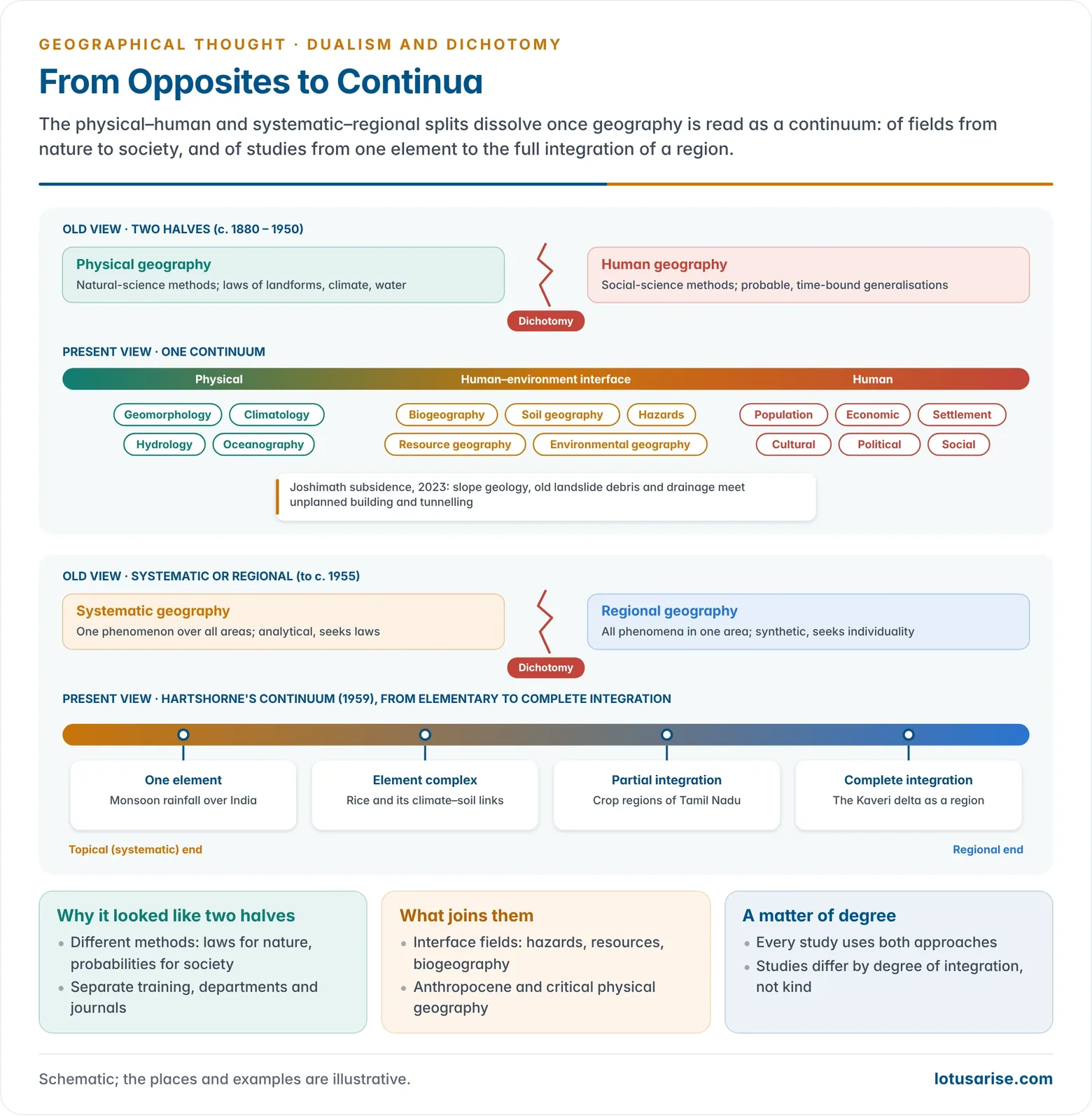
Determinism vs Possibilism
- The man–environment dualism set Ratzel and Semple’s environmental control against Vidal de la Blache’s human choice, which Febvre named possibilism (1922).
- Griffith Taylor’s neo-determinism and O. H. K. Spate’s probabilism placed the truth between the two extremes.
- The French school treated human geography as the general geography, because it saw man as an active agent; the American environmentalists kept nature in control. The quarrel between determinism and possibilism is now read as a matter of degree, within the wider paradigm of environmentalism.
Historical vs Contemporary Geography
- Kant’s pairing of history (time) with geography (space) gave the two axes of empirical knowledge: history is narrative, geography is descriptive, and each person’s limited experience of both must be supplemented by the reports of others.
- Historical geography studies places as they were in the past; for example, the cropping pattern and settlement distribution of medieval India. Contemporary geography studies existing patterns with present-day tools such as GIS and remote sensing.
- Historical geography covers both systematic and regional themes, so it stands beside the present-day branches as a complete field in itself rather than one more branch.
- Vidal de la Blache read each genre de vie through the historical evolution of a people’s relation with nature.
- Notable works:
- S. M. Ali, The Geography of the Puranas (1966), reconstructed the geography of ancient India from classical texts.
- Ralph H. Brown, Historical Geography of the United States (1948), described each region as it was when settled. W. Gordon East reconstructed Europe at several stages.
- Irfan Habib’s An Atlas of the Mughal Empire (1982) mapped the economy and routes of Mughal India.
- C. T. Smith (1965) summarised four views of historical geography:
- The geographical factor in history: the environmental context of historical events. It risks clarifying history rather than geography.
- The changing cultural landscape: settlements, house types and field patterns through time.
- The reconstruction of past geographies: cross-sections of a region at chosen dates.
- Geographical change through time: space as dynamic.
- Derwent Whittlesey’s sequent occupance (1929) showed a landscape as a series of stages of human occupation.
- Contemporary geography covers modern and postmodern developments in the subject. It uses quantitative tools, GIS and remote sensing, works across disciplines, and keeps changing its methods with each new paradigm, from positivism to behavioural and feminist geography.
- The two are linked through time: historical and contemporary geography are not separate fields, because present phenomena are fully understood only in their historical context.
- Halford Mackinder called historical geography the study of the “historical present”: today’s patterns will be tomorrow’s historical geography. The dualism is therefore illogical; the past explains the present, and the present becomes the past.
Formal vs Functional Regions
- A formal (uniform) region is homogeneous in one or more traits, such as relief, climate, soil or land use. Its logic is that uniform conditions give uniform ways of life.
- A functional (nodal) region is held together by flows of goods, people and messages around a node. Distance is measured in time, cost or network links, not kilometres.
- Pip Forer (1978) called such continually changing distances “plastic space”.
- The pair arose partly to escape the systematic–regional and physical–human quarrels. Both are now used together in regional synthesis.
- Indian example: the Malwa plateau is a formal region of black soil and basaltic relief, while the National Capital Region is a functional region defined by commuting and trade around Delhi.
Idiographic vs Nomothetic and Inductive vs Deductive
- Wilhelm Windelband (1894) coined the terms: idiographic sciences describe the unique, and nomothetic sciences seek general laws.
- Kant, Hettner and Hartshorne placed geography on the idiographic side. Schaefer, William Bunge and the spatial scientists placed it on the nomothetic side.
- Induction reasons from particular cases to general statements, and deduction from theory to cases. In the methodological contest between regional and systematic geography, regional study leaned on the first and spatial science on the second, yet the two run together in any real research.
Quantitative vs Qualitative and Positivist vs Critical
- The quantitative revolution of the 1950s and 1960s favoured measurement, models and positivism.
- Positivism brought laws and models from physics and economics into geography: Alfred Weber’s industrial location model and the gravity model of interaction are examples.
- The critical revolution answered with behavioural, humanistic, radical and feminist approaches that value meaning, power and values.
- Today mixed methods are normal: GIS and spatial statistics sit beside interviews, ethnography and participatory mapping.
Other Dualisms
- Objective vs perceived reality: spatial science assumed people respond to the world as it is. Behavioural geography held that they act on the world as they perceive it, and humanistic geography went further to seek its meaning for them.
- Pattern vs process: spatial science described patterns; later work asked how social and historical processes produce them. Derek Gregory’s call for the social organisation of space rather than the spatial organisation of society captures the shift.
- Pure vs applied (theoretical vs applied): this pair arose after the Second World War from society’s demands on geography, not from a division of content. Planning, resource management and welfare work drew on both.
- These later pairs were never true dichotomies. They were dualisms of emphasis that the discipline absorbed in the normal course of its growth.
Dualisms in Geography: Myth or Reality?
- Preston E. James (1972) called the acceptance of such dichotomies a semantic trap: giving fixed meanings to words creates unreal conflicts.
- A dichotomy does not exist when one pole is a subordinate part of the other, or when one is derived from the other.
- A dichotomy may also exist for some people and not for others, depending on the attitudes of their culture and training.
- He listed the most damaging: idiographic or nomothetic; physical or human; systematic or regional; inductive or deductive; positivist or critical; science or art.
- Arne Holt-Jensen answered that geography straddles all these pairs. Like any discipline it must be both idiographic and nomothetic, with a constant flow from one to the other, and both induction and deduction serve the same analysis.
- The case for reality:
- The halves really do use different methods; laboratory-style precision suits rivers better than societies.
- Specialisation has produced separate departments, journals and careers, especially in physical and human geography.
- The case for myth, pair by pair:
- General vs special: Varenius saw the two as interdependent, special geography supplying the empirical data from which general laws are formed.
- Systematic vs regional: Humboldt held that understanding the whole requires understanding its parts. Ritter, though inductive and regional, valued Humboldt’s systematic studies. Richthofen balanced the two, and Hettner joined idiographic and nomothetic aims. Whittlesey’s compage made regional study a matter of functional relationships, not mere description. General principles can be found only through particular cases, and particular cases are read through general principles.
- Physical vs human: human activities cannot be studied without the natural environment, because the two are inherently connected. The man–environment relationship evolved from determinism through possibilism to neo-determinism, and each half borrows the other’s ideas.
- Historical vs contemporary: time is the link. The past explains the present, and the present becomes history, so this dualism is illogical.
- The particular and the general interpenetrate: every object is unique in some features and shares others with its class.
- Conclusion: the dualisms are better understood as interconnected perspectives and methodological variations, not separate domains. Geography’s strength lies in its integrative nature, bridging the natural and social sciences through both generalisation and the study of the specific.
| Pair | Why it looked real | Why it is a myth |
|---|---|---|
| Systematic vs regional | Different units of study: theme or area | Rows and columns of one matrix |
| Physical vs human | Different methods and training | Earth surface is one human–natural system |
| Determinism vs possibilism | Opposed views of causation | Both describe degrees of a single relationship |
| Historical vs contemporary | Different periods | Present is the historical present |
| Idiographic vs nomothetic | Unique vs general | Laws are tested on cases; cases are read through concepts |
- Jan O. M. Broek (1965) gave the classic resolution: the regional–topical split resolves into the regional approach, site and situation are two aspects of place, space and time are intertwined, nature receives meaning through culture, and form and function, like quantitative and qualitative data, supplement each other.
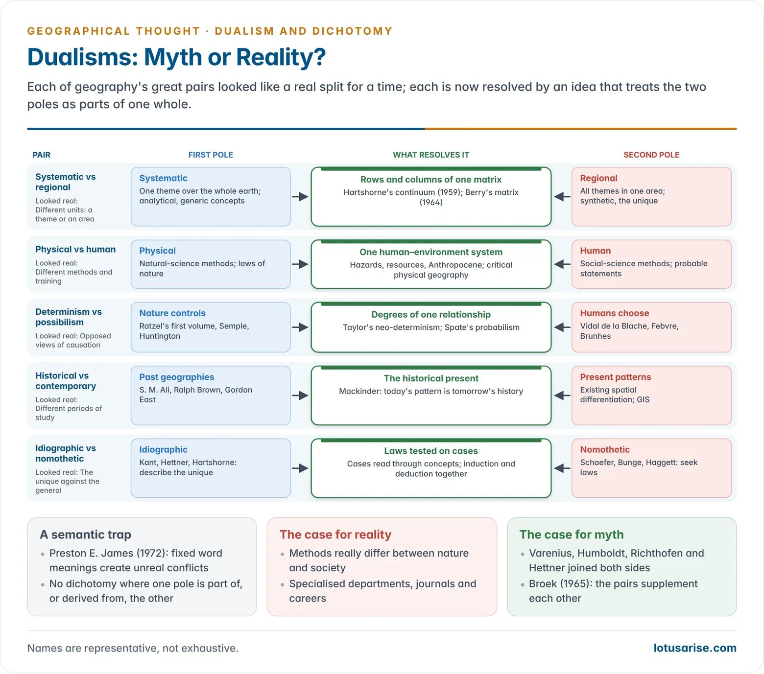
How Dualism Shaped Geography’s Methodology
- Sharper methods: each debate forced geographers to state their aims. Systematic geography adopted the analytical tools of the sister sciences, and regional geography refined synthesis and fieldwork.
- New paradigms: the systematic–regional quarrel led directly to the Hartshorne–Schaefer debate, the quantitative revolution and, in reaction, the critical approaches.
- Branching and growth: specialised branches multiplied, which enriched knowledge but weakened integration.
- Synthesis regained: Peter Haggett proposed three modes of analysis, spatial, ecological and regional complex, that cut across the old pairs. Systems thinking, GIS and earth-system science now combine physical and human data on one platform.
- Relevance: applied and welfare work now requires physical and human, regional and systematic knowledge to be used together, which keeps the dualisms in productive tension rather than in separate camps.
- Costs: the dichotomies also did damage. They encouraged narrow specialisation, left regional description in a backwater after the 1960s, and at times made the unity of the field look doubtful to outsiders.
- The dichotomies have largely faded, but dualism as a habit of debate remains productive: it keeps geography reflective about its own methods.
Previous Year Questions
2025How have dichotomy and dualism affected the methodological development of Geography? Describe.2007Write short note: Dualism in Geography.1997Critically examine the concept of dualism with special reference to physical versus human geography.





Best content in crowd of content. Thanks a lot lotusarise.
Good materials but all chapters should be covered in a expedite manner as we can prepare well before our exam….
Dichotomy of all haven’t been provided, hard topics are skipped.
right…..
Okay Guys, I will update the content, please give me some time.
U have not updated the content till now. I brought the notes yesterday and it is the same as here (incomplete)
I have updated the content.
This is the way of elaborate.
Great expectations…
Very informative content great work by team lotus arise…..thanks for uploading whole syllabus by matter
Sir…. Pls explain dualism and dichotomy with examples
Best notes
Thnku team
Best content.
the great job lotus arise .com
Sir mujhe in dono paragraph me contrast dikh raha h… Lag raha h ki dono ki definition interchange karke likh di gyi h kya… Please tell me… 🙏🏻
(1) The word ‘dualism’ simply connotes the state of being divided. For any domain of knowledge, therefore, it means two conceptually contrasted stances. Dualism finally leads to ‘dichotomy’ which means the bifurcation of any subject into branches of knowledge.
(2) The dichotomy is the contrast or difference between two ideas, connoting division in the subject matter, while Dualism is the concept of debate on a particular subject matter.
Please read again, paragraph isn’t interchanged.
Dualism means Two aspects for a same subject. For geography subject, there was two views, one is giving importance to Environment and other is giving importance to social factors. The first among the dual is referred as Environmental determinism and the other one among the dual is Social determinism.
Hence dual concepts lead to the splitting up of the subject view into two as mentioned above. Hence a dichotomy happened which means the splitting up of the subject geography on the basis of dual concepts emerged.
Thank You!
Is it complete syllabus or not
Download complete notes here https://store.lotusarise.com/product-category/geography-optional/