- An approach is the way a geographer organises the study of the earth surface: which unit is taken as the object of study, and how facts about it are gathered, analysed and arranged.
- Geography has two primary approaches: the systematic (topical or general) approach and the regional (areal or special) approach.
- They differ in method and unit of study, not in subject matter. Both deal with the same phenomena on the same earth surface.
- Their roots lie in Bernhard Varenius’s general and special geography (1650). Alexander von Humboldt (1769–1859) developed the systematic approach, and his contemporary Carl Ritter (1779–1859) the regional approach. The long quarrel between them is part of geography’s dualism.
Systematic Approach

- The systematic approach takes one phenomenon, or a small group of related phenomena, and studies its variation over the whole earth or a large part of it: “one about all”.
- It is analytical. It isolates an element, classifies its forms and seeks generic concepts and general principles, much as the systematic sciences do.
- In Fred K. Schaefer’s (1953) view, its laws concern the spatial arrangement of phenomena, not the phenomena themselves.
- Humboldt’s Kosmos (1845–62) is the classic example: isotherms, vegetation belts and climate were each traced across continents to reveal the unity of nature.
- After 1950 the approach grew into spatial analysis, relying on abstraction, statistics and models that simulate real processes, as in locational analysis.
Key Features
- Abstraction and generalisation: landforms, climate systems, vegetation, soils or population are treated in an abstract, generalised way so that the regularities beneath the earth’s variety become visible.
- Global view first: the phenomenon is examined at the world scale before typologies or spatial patterns are drawn out.
- Models and theory: models represent and simulate real processes, allow hypotheses to be tested and support prediction.
- Scale-free: systematic studies can be run at any scale without a built-in hierarchy of areas.
- Purpose: it is the approach of choice for global patterns, trends and causal relationships that cross regional boundaries, and for framing principles that apply in many settings.
How a Systematic Study Proceeds
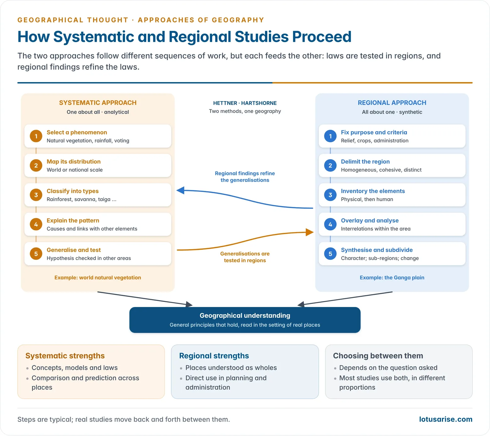
- Select the phenomenon: natural vegetation, rainfall, population density, industry or voting behaviour.
- Map its distribution at the world or national scale.
- Classify it into types and identify spatial patterns (typologies such as world vegetation types).
- Explain the pattern through its causes and its links with other phenomena.
- Generalise: frame a hypothesis and test it in other areas until it holds as an empirical law or model.
- Example: natural vegetation is first studied at the world scale, classified into types such as tropical rainforest, savanna and taiga, and then explained through climate and soil.
- Example: a hypothesis linking caste and religious cleavages with electoral turnout in Bihar becomes a generalisation only after it is tested in Uttar Pradesh, Rajasthan, Tamil Nadu and other states.
Branches
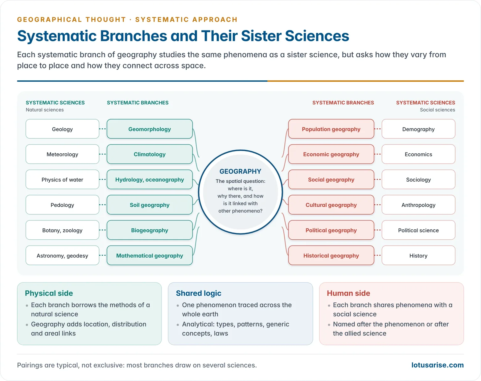
- Systematic branches are named after the phenomenon studied (electoral geography, industrial geography) or after the sister science that studies it (political geography, economic geography).
- Physical: geomorphology (geology), climatology (meteorology), hydrology and oceanography (physics of water), soil geography (pedology), biogeography (botany, zoology), mathematical geography and cartography (astronomy, geodesy).
- Human: population geography (demography), economic geography (economics), social geography (sociology), cultural geography (anthropology), political geography (political science), historical geography (history).
Strengths and Limits
- Strengths: it builds concepts, models and theories that apply across places; it allows comparison and prediction; and it keeps geography in touch with the methods of the sister sciences.
- Limits: it lifts an element out of its setting, so it cannot convey the full character of a place; it tends to fragment geography into specialisms; and general laws may ignore local conditions.
Regional Approach
- The regional approach divides the earth into regions at different levels and studies all the phenomena of one region together: “all about one”.
- It is synthetic. Its aim is to show how physical and human elements interlock to give a region its individuality, or unity in diversity.
- Regions may be natural, political, cultural or planning regions, defined for the purpose in hand.
- Ritter took the continents as his major regions and compared their highland cores, river basins and coastal lowlands; Paul Vidal de la Blache later studied the small French pays.
Key Features
- The world as a mosaic: the earth surface is seen as a mosaic of regions, each with its own distinct attributes, delimited by natural features, political boundaries or shared cultural traits.
- Holism: physical, economic and cultural elements are examined together, with attention to their interconnections, to grasp the region’s overall unity in diversity.
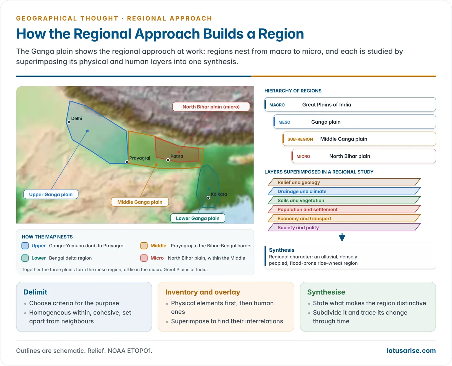
- Hierarchy of scale: regions are studied at nested levels, from local to continental, so place and scale are central.
- Identity of place: the aim is to show how environmental, cultural and socio-economic factors combine to shape a region’s identity.
- Context-bound findings: results are specific to the region and transfer to other regions only with care.
How a Regional Study Proceeds
- Fix the purpose and criteria, such as relief, climate, crops or administrative unit.
- Delimit the region. The Whittlesey Committee (1954) defined a region as an area of any size, homogeneous in the chosen criteria, with an internal cohesion that sets it apart.
- Inventory the elements: location, relief, drainage, climate, soils, vegetation and minerals; then population, economy, settlement, and social and political organisation.
- Analyse interrelations, superimposing each element on the others.
- Synthesise what is distinctive about the region and divide it into sub-regions.
- Trace change through time: are its regional structures stable or being transformed?
- Its tools are fieldwork, large-scale maps, local records and case studies, combined with quantitative data where available.
- Example: the Ganga plain is a region shaped by centuries of interaction between people and an alluvial river system. It subdivides into the Upper, Middle and Lower Ganga plains.
- The regional method, the procedure for defining and using regions, is used across geography and should not be confused with descriptive regional geography in the Hettner–Hartshorne sense.
Strengths and Limits
- Strengths: it studies real places as wholes, serves regional planning and administration (river-valley authorities such as the Damodar Valley Corporation, 1948, or the National Capital Region plan), tests systematic generalisations in specific settings, and has strong educational appeal as the geography of other lands.
- Limits:
- Regional writing can become an encyclopaedic inventory without explanation.
- Its boundaries are subjective, and it yields no general laws.
- No geographer can master every aspect of a large region. Post-war interdisciplinary area studies eased this by letting geographers concentrate on regional analysis.
The Dualism Behind the Approaches
- The two approaches carry geography’s oldest dualism. Early scholars stressed physical geography, and later ones added human geography with its emphasis on human activity and culture.
- The physical–human split did not arise from any internal need of geographical study but from philosophical abstraction. Man is an inseparable part of nature, so excluding him from the study of the earth surface is not feasible. In time each of the old dualisms settled into a pair of complementary perspectives.
Systematic and Regional Approaches Compared
| Basis | Systematic approach | Regional approach |
|---|---|---|
| Unit of study | One phenomenon over many areas | One area with all its phenomena |
| Logic | Analytical; “one about all” | Synthetic; “all about one” |
| Aim | Generic concepts, laws, models | Character and individuality of regions |
| Typical method | Mapping, classification, statistics, hypothesis testing | Delimitation, inventory, overlay, synthesis |
| Scale | World or large areas, any scale | Hierarchy of regions, from macro to micro |
| Breadth | Narrow and specialised: one component at a time | Broad and holistic: all components together |
| Methods | Often quantitative: statistics, modelling, spatial analysis | Mixed: fieldwork, mapping, case studies, data |
| Transfer of findings | Generalisations apply across many contexts | Findings are context-bound |
| Output | Climatology, economic geography, etc. | Geography of India, Monsoon Asia, a district plan |
| Founder figure | Humboldt | Ritter |
Complementarity of the Two Approaches
- Alfred Hettner placed both within geography as a chorological science: systematic study yields general concepts, and regional study tests and refines them on particular areas.
- Ferdinand von Richthofen held that every systematic study is carried out at a regional level, and every regional account rests on systematic discussion of its elements.
- Richard Hartshorne (1939) showed regional geography as the integration of all the systematic branches focused on one place. Systematic geography explains the elements; regional geography restores their colour and life.
- In Perspective on the Nature of Geography (1959) Hartshorne concluded that there is no dichotomy between the two: studies range along a continuum from topical analyses of single elements to regional analyses of the most complete integrations, and every truly geographical study uses both approaches.
- The two are thus the rows and columns of one table, as in Brian J. L. Berry’s geographic matrix (1964). The methodological contrast between regional and systematic geography concerns how far each can produce laws.
- Choice of approach depends on the objective of the study: a question about monsoon variability calls for a systematic study, while a development plan for a hill district calls for a regional one.
- Today: GIS layers built systematically are overlaid for a region, much as in regional synthesis. O. H. K. Spate and A. T. A. Learmonth’s India and Pakistan: A General and Regional Geography shows the two approaches in one study.