

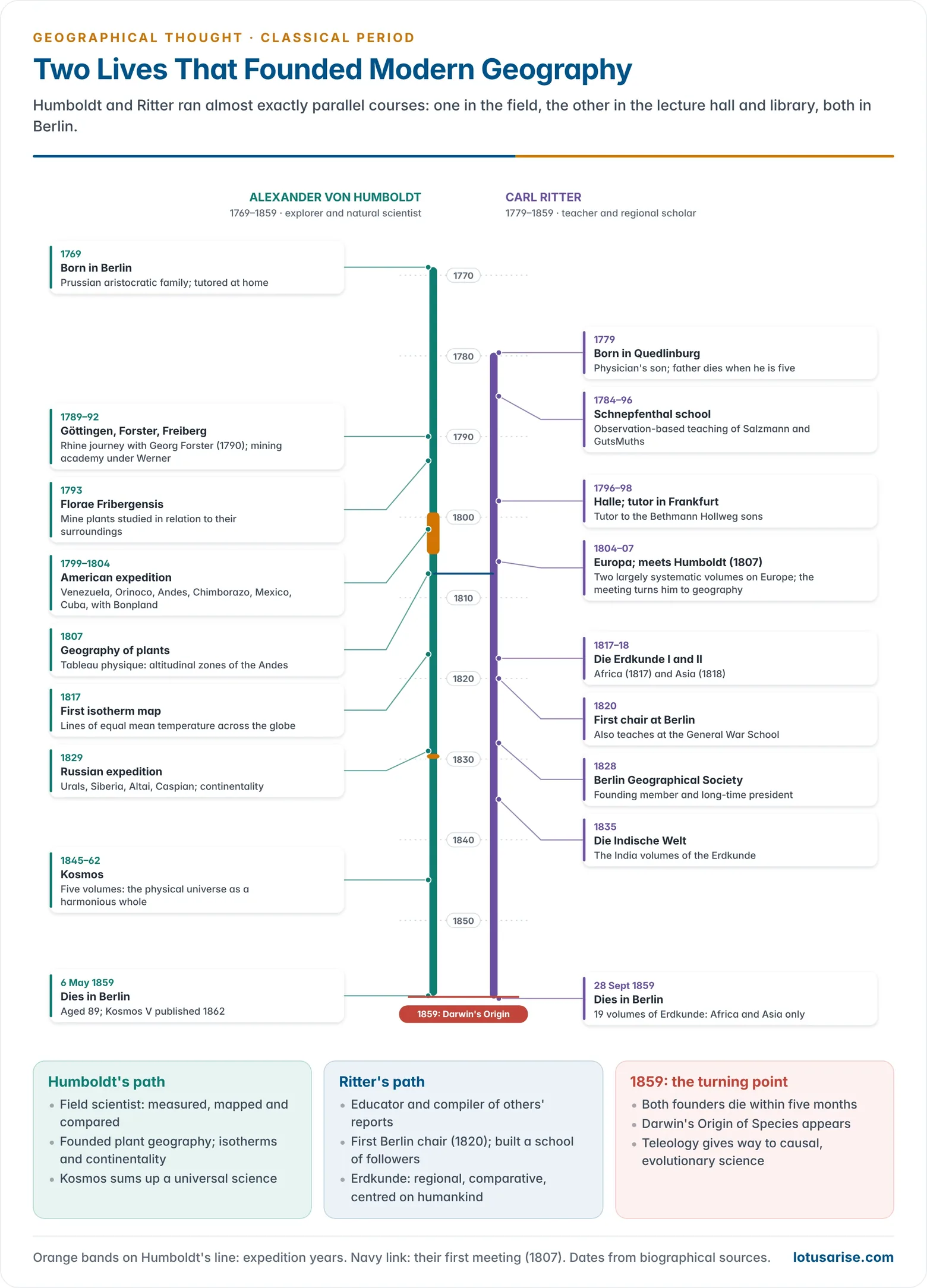
- Alexander von Humboldt (1769–1859) and Carl Ritter (1779–1859) open the classical period of modern geography. Between them they turned a loose body of travel reports and gazetteer facts into an organised, explanatory science of the earth.
- Both were German, both lived and worked in Berlin for over three decades, and both died in 1859, the year Charles Darwin published On the Origin of Species.
- Neither was trained as a geographer in the modern sense, yet they are jointly called the founders of modern geography. Humboldt is usually linked with systematic geography and Ritter with regional geography, a contrast that is useful but, as shown below, overstated.
- Their shared starting point was the conviction that the earth’s surface is a unity of interconnected parts, to be understood through observed facts rather than speculation.
The Classical Period: Setting and Shared Foundations

- Inheritance: the two built on the philosophical groundwork of Bernhard Varenius and Immanuel Kant and on the field method of Johann Reinhold Forster and his son Georg Forster, who had sailed on James Cook’s second voyage (1772–75).
- Kant had placed geography among the sciences as the study of things side by side in space. The Forsters showed how to compare places rather than merely list them.
- Material: the Age of Exploration had flooded Europe with new data. Humboldt and Ritter each produced a massive synthesis of it, in the spirit of Strabo’s universal description but with modern methods.
- Common creed:
- Science must rest on empirical observation, not on a priori systems such as Philippe Buache’s theory of continuous mountain chains dividing every river basin.
- Phenomena on the earth’s surface form a coherent whole (Zusammenhang, “hanging together”), so geography must study relations, not isolated objects.
- Human beings are part of that whole and cannot be left out of a science of the earth.
- Why “classical”: their methods were simple and broadly uniform, and their ideas dominated the founding decades of the subject. Their deaths in 1859 are taken to close the period; the impact of Darwinism and materialist science then reshaped the discipline.
Alexander von Humboldt (1769–1859)
Life and Training
- Born in Berlin into the Prussian aristocracy. His father died when he was ten, and his mother gave both sons a broad private education.
- Studies: a short spell at the University of Frankfurt (Oder) (1787), then Göttingen (1789), a commercial academy in Hamburg, and the Freiberg Mining Academy (1791–92) under the geologist Abraham Gottlob Werner.
- At Göttingen he met Georg Forster. Their 1790 journey down the Rhine to the Netherlands and England first taught him to see natural phenomena in relation to each other.
- Mining official (1792–96): as an inspector of mines in Franconia he studied plants growing in the dark of the mine galleries. Florae Fribergensis (1793) treated plants as organisms in relation to their surroundings, an early statement of plant geography.
- In Jena he came to know Johann Wolfgang von Goethe and Friedrich Schiller. From their Naturphilosophie he took the idea of nature as an organic, harmonious whole, but he never shared their distrust of measurement and experiment.
- His mother’s death in 1796 left him a fortune, and he resigned to devote himself to scientific travel.
The Great Expeditions
The American Expedition (1799–1804)
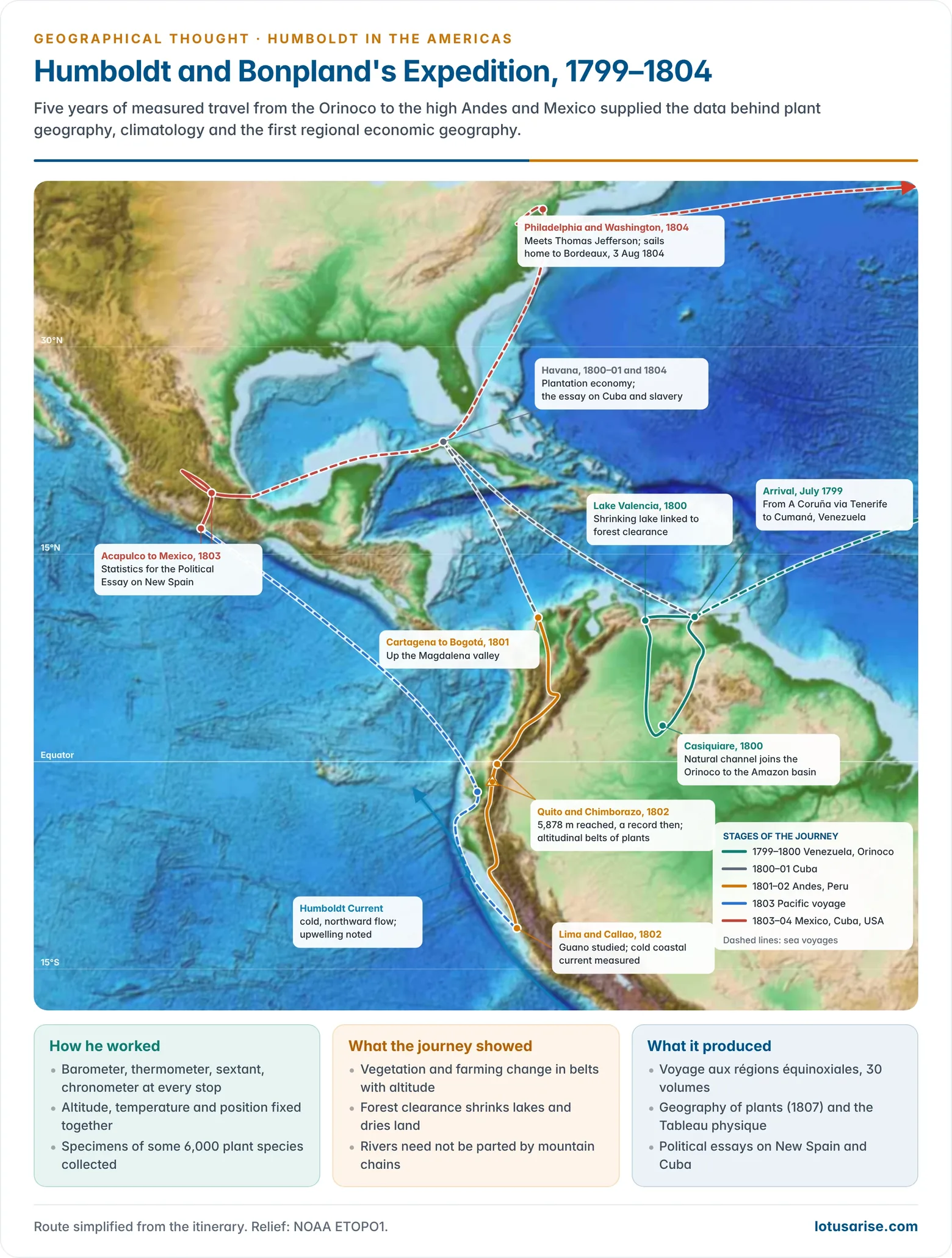
- With the French botanist Aimé Bonpland, Humboldt sailed from A Coruña on 5 June 1799 with Spanish royal permission and the best instruments of the day: barometers, thermometers, sextants, chronometers and a cyanometer for the blueness of the sky.
- Venezuela (1799–1800):
- At Lake Valencia he linked the shrinking of the lake to the clearing of forests in its basin, one of the first field tests of the effect of deforestation on water and climate.
- He traced the Casiquiare channel, which joins the Orinoco to the Rio Negro and the Amazon. This natural link disproved the idea that every river basin is walled off by a mountain chain.
- The Andes (1801–02): from Cartagena he travelled through Colombia, Ecuador and Peru, fixing latitude, longitude, altitude and temperature at hundreds of points.
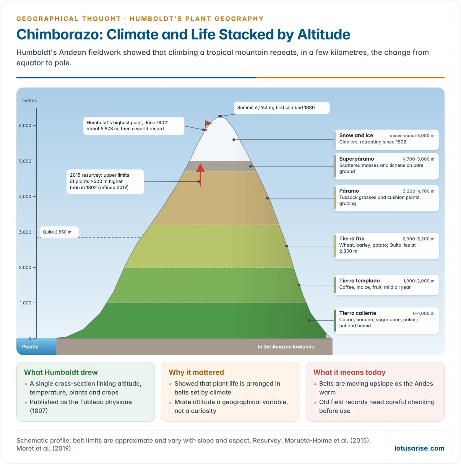
- On Chimborazo in June 1802 his party reached about 5,878 m, then a world altitude record, short of the 6,263 m summit. He related breathlessness and nausea to thin air (altitude sickness).
- His studies of Andean volcanoes convinced him that crystalline rocks have a volcanic origin, against Werner’s view that all rocks were precipitated from water.
- Pacific coast: he examined guano deposits, later exported as fertiliser, and measured the cold coastal current off Peru. He called it the Peruvian current; it now bears his name as the Humboldt Current.
- Mexico and Cuba (1803–04): in New Spain (Mexico) he gathered population, mining and trade statistics. In Cuba he documented slavery. He then visited Thomas Jefferson in the United States and landed at Bordeaux on 3 August 1804.
The Russian Expedition (1829)
- At the invitation of the Russian government he crossed the Urals into Siberia as far as the Altai and the Chinese frontier, returning by the Caspian Sea: about 15,000 km in six months.
- His temperature and pressure readings showed that places on the same latitude grow more extreme inland. On his advice Russia set up a chain of magnetic and meteorological stations across northern Asia.
Major Works
| Work | Year | Significance |
|---|---|---|
| Florae Fribergensis | 1793 | Plants studied in relation to their environment |
| Essai sur la géographie des plantes (with the Tableau physique) | 1807 | Founding text of plant geography; altitudinal zones of the Andes |
| Ansichten der Natur (Views of Nature) | 1808 | Essays such as “Steppes and Deserts”; comparative description |
| Essai politique sur le royaume de la Nouvelle-Espagne | 1808–11 | Among the first regional economic geographies |
| Voyage aux régions équinoxiales du Nouveau Continent | 1805 onwards | The 30-volume expedition report, with the Relation historique |
| “Des lignes isothermes” | 1817 | First map of isotherms |
| Essai politique sur l’île de Cuba | 1826 | Regional study with a critique of slavery |
| Asie centrale | 1843 | Mountain systems and comparative climatology of inner Asia |
| Kosmos (5 vols) | 1845–62 | His synthesis of the physical universe |
- Kosmos grew from public lectures in Berlin (1827–28) and was planned as “the work of my life”.
- Volumes I and II appeared in 1845 and 1847, III and IV in 1850 and 1858. Volume V was assembled from his notes and published in 1862.
- Vol. I gives a general picture of the universe. Vol. II traces how painters, poets and explorers have portrayed nature since antiquity. Vol. III covers the heavens. Vol. IV turns to the earth. The planned treatment of plants, animals and humankind was never completed.
- Its four aims: to define physical description of the world as a distinct field; to give an empirical portrait of nature; to show how nature acts on feeling and imagination through travel writing, poetry and landscape painting; and to trace the history of the idea of the cosmos as an ordered whole.
Geographical Concepts and Method
Unity of Nature
- Humboldt saw nature as “a unity in diversity of phenomena”: a harmony of living and non-living things bound by causal ties. The task of science was to discover that unity without losing sight of the parts.
- The unity included organic and inorganic, human and non-human elements. Leaving any of them out would break the whole.
- Unlike Ritter’s, his unity was aesthetic and scientific, not religious. Kosmos explains order in nature without appeal to a Creator.
- Zusammenhang: he took deep satisfaction in tracing how things on the earth’s surface depend on one another. This is the root of geography’s concern with areal association.
Geography’s Place among the Sciences
- Three kinds of knowledge:
- Systematic sciences (botany, zoology, geology) group objects by their kind.
- Historical sciences trace the development of things through time.
- Geography (Erdbeschreibung, physical description of the earth) studies things as they exist together in space and influence one another.
- This follows Kant’s distinction between logical and physical classification. It gave geography a distinct field: not the objects themselves but their spatial arrangement and interrelation.
- He called the whole field cosmography, divided into uranography (the heavens) and geography (the earth).
Method
- Empirical and inductive: observe, measure, classify and only then generalise. He held that facts outlast theories and kept his facts distinct from his conjectures.
- He was not a narrow empiricist. He held that general ideas must guide observation and saw no conflict between induction and deduction.
- Comparative method: every new observation was compared with similar ones elsewhere. His essay “Steppes and Deserts” sets the llanos, pampas, prairies, Sahara and Asian steppes side by side to bring out each one’s character.
- Two principles that made geography a science (as Emmanuel de Martonne later put it):
- the principle of causality, which explains the interconnection of phenomena found together;
- the principle of general geography, which compares the location and extent of phenomena over the whole earth.
- Visual method: he used cross-sections of relief to show zones of vegetation, rock and temperature, and isolines on maps. Both became standard geographical tools.
Humankind in Nature
- Humans are part of nature: dependent on soil and atmosphere, though less than plants and animals, and able to escape natural control through intellect, culture and adaptability. The influence of nature on people is strong; people’s reciprocal action on nature is weaker but real.
- He described towns, fields, crops and routes as part of the landscape, but did not make humankind its chief shaper.
- Humanist: he held that all human races share a common origin and none is inferior. He called the idea of racial gradation “not only unkind but also false”. His essays on Cuba condemned slavery, and those on New Spain exposed the unequal distribution of wealth.
Contributions to the Branches of Geography
| Branch | Contribution |
|---|---|
| Climatology | Isotherms (1817), which reach farther poleward along western coasts; continentality; a broad definition of climate covering all atmospheric changes that affect living things |
| Plant geography | Founder; altitudinal vegetation zones; plant communities linked to climate and altitude; botanical provinces |
| Geomorphology and geology | Volcanic origin of crystalline rocks; relief cross-sections; the Casiquiare bifurcation |
| Oceanography | Measured the cold Peru (Humboldt) Current and described upwelling |
| Regional and economic geography | New Spain and Cuba: resources, population and politics treated together |
| Cartography | Isoline maps, profiles and the botanical maps in his atlas of the New Continent |
- Himalayan link: in 1820 Humboldt showed that the snow line on the northern (Tibetan) side of the Himalaya lies higher than on the southern side, owing to the dry air and strong radiation of the plateau. His wish to see India himself came to nothing because the East India Company never granted permission.
Evaluation
- Achievements:
- He made geography a distinctive science of interrelations rather than a heap of facts from other sciences.
- He founded plant geography and much of climatology. He raised field measurement to a new standard.
- His New Spain was a landmark of regional description. On Richard Hartshorne’s reading, Humboldt rather than Ritter pioneered comparative regional geography.
- Limitations:
- He held no university chair, founded no school and left no disciples. His way of asking questions was rediscovered by geographers only decades later.
- By opening Kosmos with the whole universe, he made it look like the last of the great cosmographies rather than a programme for a single discipline.
- His regional writing gave human factors second place to natural ones.
- Recent reappraisal:
- The 250th anniversary of his birth (2019) and Andrea Wulf’s The Invention of Nature (2015) presented him as a forerunner of ecology and environmental thought.
- In 2015 botanists resurveyed Chimborazo and reported plant limits about 500 m higher than in his Tableau physique, a sign of warming. A 2019 re-examination showed that some of his high-altitude plant records came from the nearby volcano Antisana, so the comparison has been refined. The episode shows both the value and the hazards of historical field data.
Carl Ritter (1779–1859)
Life and Training
- Born at Quedlinburg (Saxony-Anhalt) on 7 August 1779, the son of a physician who died when Carl was five.
- Schooling: he was among the first pupils of Christian Gotthilf Salzmann’s school at Schnepfenthal, which taught through observation on the principles of Jean-Jacques Rousseau and Johann Heinrich Pestalozzi. His teacher Johann Christoph Friedrich GutsMuths trained him in geography from childhood.
- From the varied hill country around the school he drew the idea of unity in diversity, which became the theme of his life’s work.
- University and tutorship: he studied at Halle (from 1796). From 1798 he tutored the sons of the Frankfurt banker Bethmann Hollweg, travelling with them in Switzerland and Italy and later studying with them at Göttingen. He met Pestalozzi in Switzerland and Humboldt in 1807.
- Berlin: in 1820 he became the first holder of a chair of geography at the University of Berlin, teaching at the same time at the General War School (Kriegsschule). He became full professor in 1825.
- He was a founding member of the Berlin Geographical Society (Gesellschaft für Erdkunde, 1828) and its long-time president.
- Unlike Humboldt, he was mainly a scholar and teacher. He worked from the reports of others rather than from his own expeditions.
Die Erdkunde
- Title: Die Erdkunde im Verhältnis zur Natur und zur Geschichte des Menschen, oder allgemeine vergleichende Geographie: “The science of the earth in relation to nature and the history of mankind, or general comparative geography”.
- Publication:
- Volume I (Africa) appeared in 1817 and Volume II (Asia) in 1818. Their success brought him the Berlin chair.
- A rewritten edition began in 1822. By his death 19 volumes had appeared, covering only Africa and Asia.
- The India volumes (Die Indische Welt, 1835) compiled everything then known about the subcontinent’s relief, rivers, products and peoples.
- Earlier work: a two-volume geography of Europe (1804–07) and an unpublished handbook of physical geography (1810), both largely systematic.
- Purpose: to replace the “lifeless summary of facts about countries and cities” with a new scientific geography. In his words, the task was to move “from mere description to the law of the thing described”, and to find the connection of place with place.
Geographical Concepts
Earth as the Home of Man
- Geography studies the earth’s surface as the home of humankind, not the whole planet. The central principle is the relation of all natural forms and phenomena to the human race.
- Reciprocal relation: “land affects the inhabitants and the inhabitants the land”. Hence history and geography are inseparable.
- Because he stressed this two-way influence, it is wrong to label him a determinist, though later environmentalists drew on his continental generalisations.
- He chose the name Erdkunde (earth science) over Erdbeschreibung (earth description) to signal an explanatory science. The literal meaning later tempted some geographers to claim every aspect of the earth as their field.
Unity in Diversity and the Organic Whole
- Every naturally bounded area is a unity of climate, products, culture, population and history. The geographer’s job is to see its features in their interrelation and so reconstruct the whole.
- He spoke of the earth as an organism, the continents as its organs or individuals, and their parts as members. Each part reflects the whole.
- The idea combined Kant’s whole (Ganzheit), the regional individuality of August Zeune and the Forsters, and the organic idealism of Georg Wilhelm Friedrich Hegel and Friedrich Wilhelm Joseph Schelling.
Teleology
- Ritter’s science was teleological: he looked for the purpose behind the order of nature. That purpose was God’s plan for the education of humanity: “as the body is made for the soul, so is the physical globe made for mankind”.
- He offered teleology only where science could give no answer: the uniqueness of the earth, the existence of humankind, and the different characters of the continents.
- Continents in the divine plan:
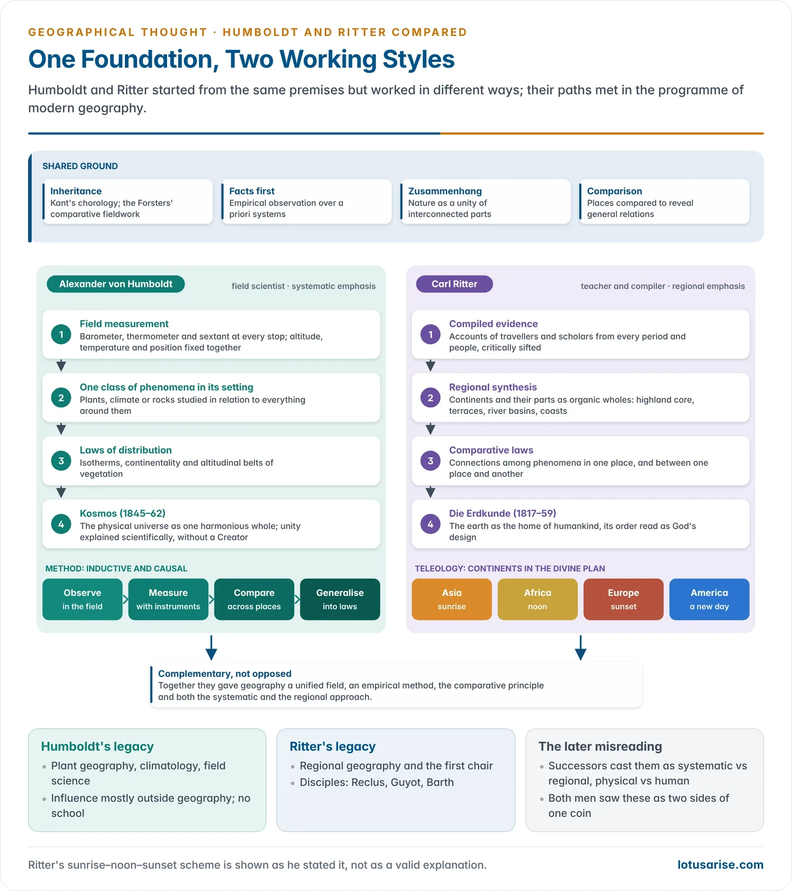
- Asia was the sunrise, where civilisation began.
- Africa was the noon, its smooth coasts and uniform climate inducing slumber and isolation.
- Europe was the sunset, the culmination of human achievement, its indented coast open to the sea.
- America promised a new day, and the polar lands were midnight.
- In practice his method stayed empirical. He collected evidence from every period and people, insisted that his system rested on facts, not philosophical argument, and sought the divine plan only through the facts.
Empirical and Comparative Method
- “We must ask the earth itself for its laws.” Knowledge of the earth must come from observation, not from rational principles or a priori theory.
- He was among the first to show from records that mountain crests and drainage divides do not coincide, which demolished Buache’s system.
- Comparative geography: causal relations were to be found by comparison, as anatomists compared organisms. This is why Erdkunde is subtitled “general comparative geography”.
- Areal association and spatial interaction: he sought connections between phenomena in the same place and between one place and another.
- Three attributes of place:
- the topical: natural divisions of the surface;
- the formal: water, sea and atmosphere, the bases of human life;
- the material: the distribution of minerals, plants and animals.
- Boundaries: rivers and mountains (“wet and dry” boundaries) matter only as means to understand the content of areas.
Regional Method
- Regional synthesis first: he urged geographers to study areas filled with interrelated phenomena region by region. Once the whole world was covered, sound systematic generalisations could follow.
- Scale: his major units were the continents (Erdteile). Each was divided by relief into a highland core, surrounding terraces, major river basins and coastal lowlands, an order he believed all continents shared.
- In practice he also used climate and vegetation, as in his division of the Sahara.
- He organised material chorologically, both horizontally (area by area) and vertically (by altitude).
Evaluation
- Merits:
- He gave geography its first university base, its regional framework and a clear statement of its aims in methodological essays.
- His critical, exhaustive use of sources set new standards of scholarship and synthesis.
- His holistic, human-centred view anticipated the regional and human geography of the next century.
- Criticism:
- Teleology cannot be tested and so is not scientific explanation. After 1859, materialist, cause-and-effect science and Darwin’s struggle and random variation left it with no place.
- He was largely an armchair geographer.
- Taking continents as regions encouraged sweeping generalisations, including a crude matching of continents with races and colours, and in the long run retarded regional study.
- Influence: through the only chair in Germany he left a school of followers.
- Élisée Reclus wrote a 19-volume Nouvelle géographie universelle (French school).
- Arnold Guyot carried his ideas to the United States.
- The explorer Heinrich Barth was also his student.
- Most geographers of the next generation therefore practised geography as regional description.
Humboldt and Ritter Compared
Common Ground
- Both rejected speculative, a priori geography and insisted on empirical foundations.
- Both saw the earth as a unity in diversity bound by Zusammenhang, and both included humankind within the whole.
- Both used the comparative method and sought general laws behind areal patterns.
- Each acknowledged the other. Ritter called Humboldt the founder of comparative geography and said his own work would have been impossible without him. Humboldt praised Erdkunde in the first volume of Kosmos.
Points of Difference
| Aspect | Humboldt | Ritter |
|---|---|---|
| Training and career | Mining engineer, scientist, explorer; no chair | Educationist and historian; first Berlin chair (1820) |
| Source of data | Own field observation and measurement | Compilation of others’ reports |
| Main emphasis | Physical phenomena: climate, plants, relief | Humankind and history in relation to land |
| Approach | Largely systematic, also regional (Mexico, Cuba) | Largely regional, while valuing systematic study |
| Unity of nature | Scientific and aesthetic | Religious: God’s design |
| Explanation | Causal, mechanistic | Teleological, purposive |
| Scale of study | Particular phenomena over the whole globe | Continents and their parts |
| Main work | Kosmos (1845–62) | Die Erdkunde (1817–59) |
| Legacy | Plant geography, climatology; no school | Regional tradition; many disciples |
A Dichotomy Read Back into Them
- Their successors cast them as rivals: Humboldt as the father of systematic (physical) geography and Ritter of regional (human) geography. This became the root of the later dualisms in geography.
- The two themselves saw systematic and regional study as two sides of one coin, and both studied people and nature together. Their different styles were complementary, not opposed.
Joint Legacy
- Together they gave modern geography an almost complete programme: a unified field, an empirical method, the comparative principle, and the twin systematic and regional approaches.
- Their chorological view passed through Alfred Hettner to Richard Hartshorne’s idea of areal differentiation. Their holism foreshadowed today’s earth-system and human–environment geography.
- After 1859 the German school moved from their idealism towards Darwinian, law-seeking science, but it kept their insistence on field evidence and areal synthesis.
Previous Year Questions
1992Give a comparative assessment of the works of Humboldt and Ritter leading to the foundation of modern geographical thought.





Thank you sir for amazing content🙏🙏
Specially for comparison between Hamboldt and Ritter