

- Geographical thought is the history of the ideas, concepts and methods through which people have tried to describe and explain the earth as the home of humankind.
- It records, in Preston E. James’s phrase, the effort to gain “more and more logical and useful knowledge” of the human habitat and of humanity’s spread over the earth.
- Geography has a longer genealogy than almost any other science. The earliest written records already contain observations about places, routes, seasons and peoples.
- Each civilisation drew on its own setting. Astronomy flourished under the clear skies of Chaldea, Assyria and Babylonia, geometry on the surveyed flood lands of the Nile, and physical geography in Greece, with its varied relief and indented coastline.
- The subject became a modern university discipline only in the 1870s. Its history is therefore a long pre-scientific stage followed by about 150 years of rapid, contested change.
- That history is often described as one of dichotomies and abandoned theories: each generation’s explanations failed to satisfy the next, and the search for better ones produced the paradigms of the discipline.
Periods of Geographical Thought

Why the History of Ideas Matters
- Contextual history: ideas are best understood in the social, political and intellectual setting in which they arose, not judged only as true or false.
- Determinism matched the age of empire. Quantification matched post-war faith in science and planning. Radicalism matched the protests of the late 1960s.
- John Kirtland Wright (1926) called for a history of geographical ideas. David Stoddart (1986) dated modern geography to 1769, when James Cook entered the Pacific with trained scientific observers.
- Three persistent questions run through every period:
- Where is it? Absolute and relative location.
- What is it like? Description and classification.
- Why is it there, and what does it mean? Explanation, which may be inductive or deductive.
- Persistent themes: the man–nature relationship, the region and areal differentiation, and spatial organisation. Each period gives one of them priority.
A Working Periodisation
- Richard Hartshorne’s The Nature of Geography (1939) and Perspective on the Nature of Geography (1959) were the first major attempts to trace the discipline’s past in order to define its nature.
- The periodisation below is the conventional one used in the subject. It is a teaching scheme, not Hartshorne’s own classification.
| Period | Approx. time | Character | Key figures |
|---|---|---|---|
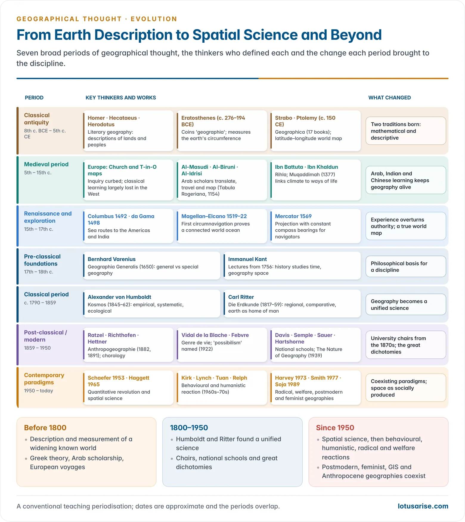
| Classical antiquity | 8th c. BCE–5th c. CE | Mathematical and descriptive geography; the spherical earth measured | Homer, Herodotus, Eratosthenes, Strabo, Ptolemy |
| Medieval period | 5th–15th c. | Europe’s “dark age”; Arab, Indian and Chinese scholarship leads | Al-Masudi, Al-Biruni, Al-Idrisi, Ibn Battuta, Ibn Khaldun |
| Renaissance and Age of Exploration | 15th–17th c. | Voyages, new maps and instruments; experience overturns authority | Columbus, Vasco da Gama, Magellan, Mercator |
| Pre-classical (foundations) | 17th–18th c. | Philosophical basis of geography as a discipline | Bernhard Varenius, Immanuel Kant |
| Classical period | c. 1790–1859 | Geography as a unified scientific study | Alexander von Humboldt, Carl Ritter |
| Post-classical / modern | 1859–1950 | Professional geography, national schools, great debates | Ratzel, Richthofen, Hettner, Vidal de la Blache, Davis, Hartshorne |
| Contemporary | 1950 onwards | Successive and coexisting paradigms | Schaefer, Haggett, Harvey, Tuan, Smith, Soja |
Pre-Modern Foundations
Classical Antiquity
- Classical antiquity is the long period of Mediterranean civilisation centred on ancient Greece and Rome.
- It is usually counted from the epics of Homer (8th–7th century BCE) to the decline of the Western Roman Empire (5th century CE). It shades into the early Middle Ages during late antiquity (c. 300–600 CE).
- Greece sat at the crossroads of ancient trade routes. Its scholars gathered knowledge from Egypt, Mesopotamia and Persia, and from Alexander’s eastern campaigns, and built it into theory.
- Their horizon stretched from Spain and Gaul to the Russian steppes, the Indus and Ethiopia.
- Two traditions emerged and still run through the subject:
- Mathematical tradition: fixing locations, shape and size of the earth. Thales and Anaximander began it, Aristotle argued for a spherical earth, and Eratosthenes (c. 276–194 BCE) carried it to its height.
- Eratosthenes coined the word geographia (“earth description”) and computed the earth’s circumference remarkably close to the true value.
- Hipparchus proposed locating places by latitude and longitude. Ptolemy (c. 150 CE) built maps on that grid, the root of the graticule and map projection.
- Literary or descriptive tradition: describing lands and peoples. It runs from Hecataeus and Herodotus to Strabo, whose 17-book Geographica is the classic regional description of the known world.
- Mathematical tradition: fixing locations, shape and size of the earth. Thales and Anaximander began it, Aristotle argued for a spherical earth, and Eratosthenes (c. 276–194 BCE) carried it to its height.
- Rome added practical, administrative geography: road itineraries, surveys and the mapping of Britain and western Europe for a governing empire.
- Parallel traditions grew in China (the Yu Gong, Pei Xiu’s grid maps) and in India (the Puranic dvipas, the Surya Siddhanta and Aryabhata’s rotating earth).
- Limitation: theory ran far ahead of observation. Ptolemy’s authority, including his underestimate of the earth’s size, held for some 1,300 years.
The Medieval Period: Europe’s Dark Age and the Arab Ascendancy
- In Europe, the Middle Ages (c. 476 CE to the Renaissance) were long called the “Dark Ages” for geographical learning.
- The Church controlled education. Inquiry that questioned scripture risked the charge of blasphemy.
- Classical knowledge was largely lost in the West. Maps became symbolic T-in-O maps with Jerusalem at the centre.
- The Arabs carried the subject forward between the 8th and 14th centuries.
- Under the Abbasid caliphs, Greek and Indian works were translated into Arabic (Ptolemy’s Almagest among them), and trade across the Indian Ocean and Asia’s land routes gave first-hand knowledge.
- The word monsoon comes from the Arabic mausim (season).
- Al-Masudi (d. 956) wrote on climate and on human character. Al-Biruni (973–1048) wrote Kitab al-Hind (c. 1030) and measured the earth’s radius. Al-Idrisi made a world map for Roger II of Sicily (1154). Ibn Battuta (1304–1368/69) travelled about 120,000 km. Ibn Khaldun’s Muqaddimah (1377) linked climate to ways of life.
- The Crusades and contact with Arab Spain brought Aristotle and Ptolemy back to Europe, where they were reworked, sometimes in error.
- In the late Middle Ages, travellers such as Marco Polo (in Asia 1271–1295) brought new information. Portolan sea charts began to improve navigation. These prepared the ground for the Renaissance.
The Renaissance and the Age of Exploration
- The Renaissance revived classical learning and faith in human capability over dogma. Rulers and merchants backed the search for a sea route to the spices of India and the East.
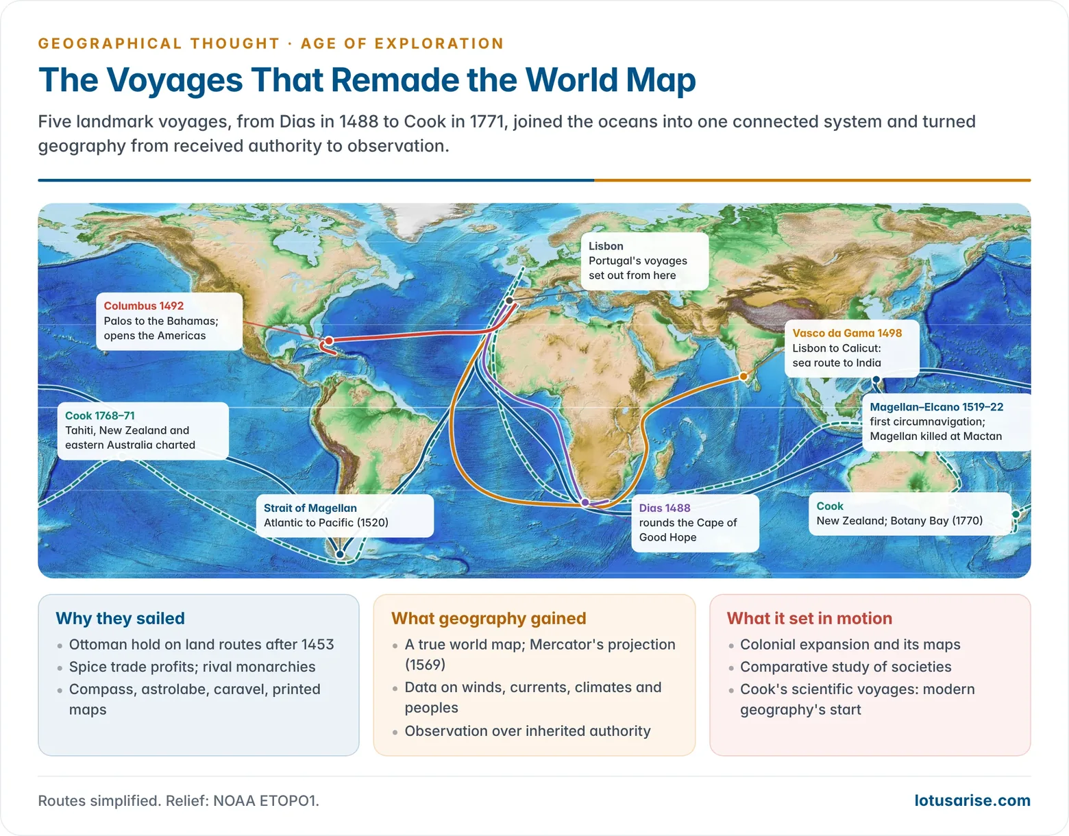
- Push factors: the Ottoman hold on land routes after 1453, rivalry among the new monarchies, and the profits of the spice trade.
- Enabling tools: the magnetic compass, astrolabe and quadrant, the caravel, and printed maps.
- Major voyages:
- Bartolomeu Dias rounded the Cape of Good Hope (1488).
- Christopher Columbus reached the Caribbean (1492).
- Vasco da Gama reached Calicut (1498).
- Amerigo Vespucci sailed along South America (1499–1502). His recognition of a “New World” led Martin Waldseemüller to name it America (1507).
- Ferdinand Magellan’s expedition, completed by Elcano, sailed round the world (1519–22).
- James Cook mapped the Pacific, New Zealand and eastern Australia (1768–79).
- Effects on geography:
- It produced a true world map for the first time. Gerardus Mercator’s projection (1569) answered the navigator’s need for constant compass bearings.
- Experience triumphed over authority. Observed fact overturned inherited theory, which helped give rise to experimental science.
- New data appeared on currents, winds, tides, climates, plants and peoples. Cultural relativism slowly grew from contact with other societies.
- It also opened the age of colonial expansion. Geographical knowledge became a tool of empire, a link later critics stressed.
The Pre-Classical Phase: Philosophical Foundations
- In the 17th and 18th centuries, scholars laid the philosophical basis that made geography possible as a discipline.
- Bernhard Varenius (1622–1650), in Geographia Generalis (1650):
- He divided geography into general geography (laws of the whole earth) and special geography (description of particular regions). This is the root of the later systematic–regional dualism.
- He accepted the heliocentric universe of Copernicus, Kepler and Galileo.
- Immanuel Kant (1724–1804) lectured on physical geography at Königsberg from 1756 to 1796.
- He classified knowledge logically, by kinds of things, which gives the systematic sciences. He also classified it physically, by where and when things occur: history studies phenomena in time, geography in space.
- This gave geography a respected place among the sciences as a chorological (place-centred) study. Hettner and Hartshorne later built on it.
Modern Geography
The Classical Period: Humboldt and Ritter
- Alexander von Humboldt and Carl Ritter (1769–1859 and 1779–1859) turned scattered knowledge into a unified scientific geography. Both died in 1859, the year Darwin published On the Origin of Species.
- Humboldt: explored the Americas (1799–1804) and drew the first isotherms. He described altitudinal vegetation zones on Chimborazo. His Kosmos (1845–62) presented the earth as a harmonious whole. His method was empirical, systematic and ecological.
- Ritter: wrote Die Erdkunde (19 volumes, 1817–59) and held Berlin’s first chair of geography (1820). His approach was regional, comparative and teleological. He stressed the earth as the home of man and the unity in diversity of regions.
- Together they set up the two lasting approaches, systematic (Humboldt) and regional (Ritter).
The Post-Classical Period: Institutions, Schools and Debates
- Crisis after 1859: knowledge was splitting into separate sciences of nature and of society. Geography, which studied both, faced an identity crisis: what was left for it to study?
- Institutionalisation: the first university chairs came in the 1870s. They began in Germany, where Prussia resolved in 1874 to create chairs in all its universities, and spread to France, Britain and the United States.
- Darwin’s ideas of evolution, adaptation and struggle shaped the new discipline.
- National schools grew up, each with its own emphasis:
- German: Ratzel, Richthofen, Hettner and Penck.
- French: Vidal de la Blache, Brunhes and the genre de vie.
- British: Mackinder, Herbertson, Roxby and Stamp.
- American: Davis, Semple, Huntington, Barrows and Sauer.
- Russian/Soviet: Dokuchaev, Anuchin and Baransky.
- The great dichotomies (late 19th to mid-20th century) set the agenda of the subject.
- Physical vs human geography: both are now accepted as necessary. Human geography explains the human factor in environmental change and growing technological power.
- Man vs environment: this is the debate between determinism and possibilism.
- Friedrich Ratzel’s Anthropogeographie (vol. 1, 1882; vol. 2, 1891) gave determinism its scientific form. His second volume, on the distribution of peoples, left more room for human agency.
- Paul Vidal de la Blache and the French school stressed choice within nature’s possibilities. Lucien Febvre named this possibilism (1922).
- Griffith Taylor’s neo-determinism (stop-and-go determinism) held that nature sets the limits and route, and humans set the pace.
- For example, rainforest cannot be grown in the Sahara, and the tundra’s climate limits farming. Humans may use what nature offers, but within its limits.
- General (systematic) vs special (regional) geography: this dispute ended in the Hartshorne–Schaefer debate.
- Hartshorne (1939) saw geography as the study of areal differentiation, mainly idiographic and descriptive of the unique.
- Fred K. Schaefer (1953) attacked this exceptionalism and called for a nomothetic, law-seeking spatial science.
The Quantitative Revolution and Spatial Science (1950s–1960s)
- Post-war conditions encouraged the change. These included wartime operational research, computers, planning needs, and the prestige of the physical sciences under logical positivism.
- The quantitative revolution produced the following:
- Statistics, mathematics and models became the tools of geography. The Washington school (William Garrison), William Bunge’s Theoretical Geography (1962), Peter Haggett’s Locational Analysis in Human Geography (1965) and Chorley and Haggett’s Models in Geography (1967) were landmarks.
- Older location theories were revived and extended: von Thünen, Weber, Christaller and Lösch.
- It rested on simplifying assumptions, such as the isotropic surface and the rational economic man.
- Geography moved from description to locational analysis and from regions to spatial organisation.
- Weaknesses: its laws were normative, describing ideal rather than real behaviour. It ignored values, perception and the dynamic behaviour of people.
The Critical Reaction: Behavioural and Humanistic Geography (1960s–1970s)
- The critical revolution arose from dissatisfaction with spatial science. It questioned normative assumptions and spurious generalisations, and models that did not reflect reality. It developed along two lines:
- Behavioural geography:
- It replaced economic man with the perceiving, deciding person. Key works include William Kirk’s behavioural environment, Kevin Lynch’s The Image of the City (1960), Julian Wolpert’s satisficer (1964) and mental maps.
- It kept generalisation and quantification, as a refined form of positivism.
- Humanistic geography:
- It rejected law-making and quantification. Every person and place is unique, so the aim is understanding (verstehen) of meaning, values and sense of place.
- It drew on phenomenology, existentialism and idealism: Yi-Fu Tuan (Topophilia, 1974), Edward Relph (Place and Placelessness, 1976) and Anne Buttimer.
The Relevance Movement: Radical and Welfare Geography (1970s)
- The late 1960s brought the Vietnam War, civil-rights struggles, urban riots, poverty and environmental crisis. Geographers asked what their work was for.
- Wilbur Zelinsky’s “Beyond the Exponentials” (1970) urged geographers to confront the crises of growth. Social relevance became the measure of research.
- Radical geography: it used Marxist and anarchist ideas. The journal Antipode was founded in 1969, and William Bunge led the Detroit Geographical Expedition. David Harvey’s Social Justice and the City (1973) explained spatial inequality through capitalism and called for structural change.
- Welfare geography: this is the liberal-reformist stream. David M. Smith (1977) asked “who gets what, where, and how” and sought territorial social justice within the existing system.
- Welfare geography is reformist and policy-oriented; radical geography seeks structural change. Both put inequality at the centre.
Postmodern, Feminist and Contemporary Geographies (1980s onwards)
- Postmodern and feminist geographies questioned grand theories and universal truths. They stressed difference, identity, gender and the voices of the marginalised.
- Key works: Edward Soja’s Postmodern Geographies (1989) and the Women and Geography Study Group’s Geography and Gender (1984).
- Space, place and locality returned to the centre of the subject. Space came to be seen as socially produced, through Henri Lefebvre and the socio-spatial dialectic.
- Time geography linked space and time in everyday life.
- New regional geography revived the region in a new form.
- The cultural turn of the 1990s was followed by GIS and GIScience, remote sensing and big data, which made quantitative methods newly powerful.
- Current directions: critical physical geography, political ecology, the Anthropocene, climate change and disaster risk, and decolonial geographies that challenge the Eurocentric origins of the discipline.
Evaluation: Continuity, Change and Convergence
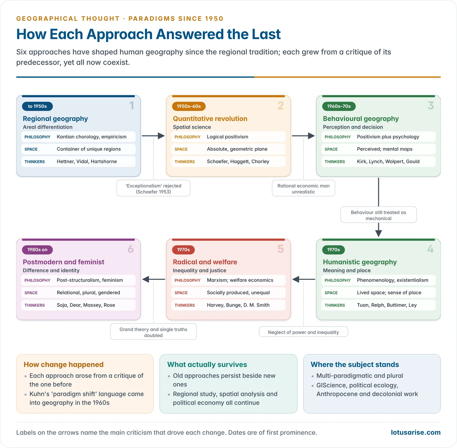
- Paradigm view: using Thomas Kuhn’s The Structure of Scientific Revolutions (1962), Haggett and Chorley read geography’s history as a series of paradigm shifts. Each shift follows a crisis in the ruling model.
- Coexistence, not replacement: in practice, earlier approaches survive alongside newer ones. Regional study, spatial analysis, behavioural work and political economy all continue.
- This makes geography multi-paradigmatic rather than a neat succession of revolutions.
- Continuity of themes: man–nature relations, areal differentiation and spatial organisation recur in every period. They are reworked rather than abandoned.
- Environmentalism, for example, has returned through climate change and sustainability.
- Convergence: by the 1990s, earlier divisions had softened into complementary perspectives. These were regional and systematic, idiographic and nomothetic, and humanistic and Marxist.
- Eurocentrism: the received history centres on Europe and North America. Arab, Indian and Chinese traditions and colonial knowledge-making are now being written back into it.
| Approach | Era | Philosophy | View of space | Method |
|---|---|---|---|---|
| Regional / areal differentiation | to 1950s | Kantian chorology, empiricism | Container of unique regions | Description, synthesis |
| Quantitative / spatial science | 1950s–60s | Logical positivism | Absolute, geometric | Models, statistics |
| Behavioural | 1960s–70s | Modified positivism, cognitive psychology | Perceived space | Surveys, mental maps |
| Humanistic | 1970s | Phenomenology, existentialism, idealism | Lived space, place | Interpretation, ethnography |
| Radical / welfare | 1970s | Marxism / liberal welfare economics | Socially produced, unequal | Political economy, social indicators |
| Postmodern / feminist | 1980s onwards | Post-structuralism, feminism | Relational, plural | Discourse, qualitative, mixed |
Previous Year Questions
1999Describe the sequence of major paradigm shifts in geographic thought during the twentieth century.1989Write an essay on the contribution of European geographers to the development of geographic thought.


thanks a lot!!!!!!!!!!!!! this is the only platform giving such precious thing for free……………. it is very helpful for lots of aspirants like me .
Most Welcome
Thanks a lot
VERY GOOD MATERIAL FOR UPSC OPTIONAL GEOGRAPHY AND THANKS FOR SUPPORTS TO STUDENTS FREE OF COST.
AS A FEED BACK
SIR ITS VERY GOOD BUT YOU CAN CHANGE TO EXILENT BY
-SHORTING AND WRITE ONLY IMPORTANT MATERIALS
-ALL TOPICS NOTICE DONE WHICH REMAINING
Complete Notes – https://lotusarise.com/optional/geography-optional-upsc/
thanks for making the things precise and understable for the aspirants.
hello sir where can I find your geography articles other than notes
god bless u!
Thank you so much
thank u sir
I’m a beginner in Geography Optional and these notes are helping me a lot to understand the things in a simple manner. Thanks a lot and please continue your good work.
Flow chart of evolution of geography is excellent..wonderful work done sir
sir u have the word regional Vs special but special word has been used for regional itself given in Dixit book Ch 1of varenius discussion
and there is dichotomy of regional Vs systematic.
There was a typing error, I have corrected the same, Thanks for pointing out the mistake.
Grt work sir ,ty so much
thanku from the core of my heart,may god bless u ……..
Very benefiting for us plz sir post all remaining parta..
Yes, it is very Helpful, So please share remaining concept also……
Paradise for geography optional aspirants !!
Thank you so much for your valuable support.
Thank you sir,
live long and stay blessed
I’ve done optional foundation and 500+ and after reading this I’ll say… This is a top notch content. That too easily available. Thank you whosoever is doing this.
Keep Reading
Thanks sir , such a great source … Can i rely on it
Updated from current affair too
Please check this:
‘It’s up to man how he utilizes the possibilities provided by Man but it has limitations too.’
This statement is incorrect. The correct version should be:
‘It’s up to man how he utilizes the possibilities provided by Nature/Environment, but it has limitations too.'”