

- The Himalayan mountain system and the Tibetan Plateau are the product of the collision of the Indian and Eurasian plates, a collision that has not stopped.
- Older accounts place its start 40–50 million years ago. Sediment records now date the first contact to about 59 ± 1 million years ago in the central Himalaya, and a 2025 review brackets it at 65–59 million years, reaching the western and eastern ends by 55–50 million years.
- Continental crust is too light to sink far. The two landmasses have about the same low rock density, so neither could go down as oceanic crust does.
- The pressure was relieved by thrusting upward, which crumpled the collision zone into the jagged Himalayan peaks.
- India’s edge was still dragged to depth for a time. Rocks at Tso Morari in Ladakh record partial continental subduction at about 50–47 million years ago.
Himalayas Formation
From the Tethys to the Mountains
- The Himalaya is among the youngest mountain chains in the world and also the loftiest.
- There is near-unanimous agreement on two things: the range rose out of a great geosyncline, the Tethys, and it rose in phases. The process, the timing and the forces remain disputed.
- Those who wrote on its origin include Oskar Spate, Darashaw Nosherwan Wadia, Maharajapuram Sitaram Krishnan, Sidney Burrard, Edwin Pascoe, Guy Pilgrim, Hellmut de Terra, T. T. Paterson, Toni Hagen, John Auden, Arnold Heim and August Gansser.
- The geosynclinal view of Eduard Suess, Émile Argand and Leopold Kober has a sinking sea floor filled with sediment, which was then squeezed between two forelands. The plate account took over the mechanism but kept the sediment story.
- Pangaea existed in the Permian. The old date of 250 million years marks that period’s close: it ran from about 299 to 252 million years ago.
- Northern part, Laurasia: present-day North America and Eurasia (Europe and Asia). It is also called Angaraland, strictly its Siberian core. Laurentia is strictly the North American core.
- Southern part, Gondwanaland: South America, Africa, Peninsular India, Australia and Antarctica.
- The Tethys lay between them, as first set out in the continental drift theory.
- It is often described as a long, narrow, shallow sea. That fits its shelves. Reconstructions treat the Neotethys as a true ocean floored by oceanic crust, whose fragments survive in the suture.
- Rivers fed it from both landmasses, and some Himalayan rivers are older than the mountains they now cross.
- Their sediments piled up on the Tethys floor and were compressed and folded as the Indian Plate moved north.
- It matters little to the outcome whether Angaraland moved south, Gondwanaland north, or both. Most scientists favour the northward movement of Gondwanaland.
- The summit of Mount Everest is marine limestone, the fact most often used to show this process.
- The rock is the Ordovician Qomolangma Formation, which is older than the Neotethys but makes the same point: sea-floor sediment now stands at the top of the world.
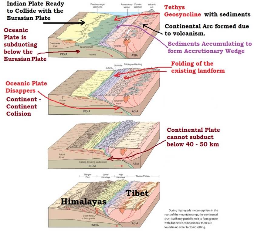
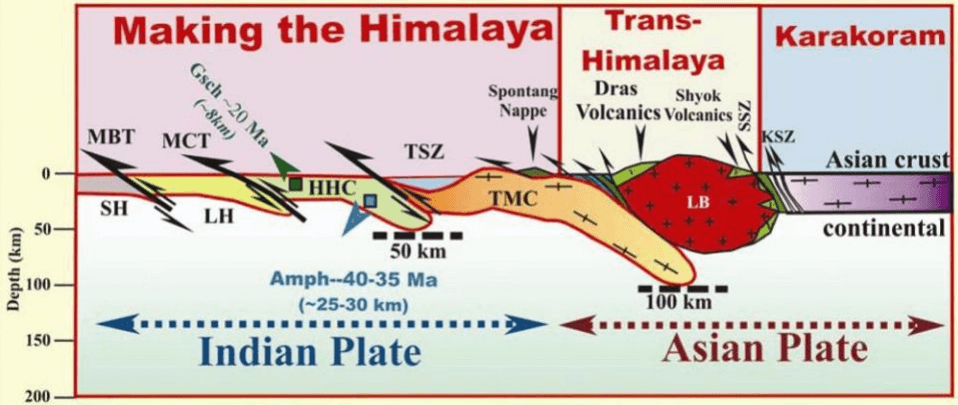
- In this figure, the label limiting continental subduction to 40–50 km is too strict. Metamorphic rocks show India’s leading edge going much deeper before it stalled.
- Once the Indian plate plunged below the Eurasian plate, the sediments were folded and raised further. This is still going on.
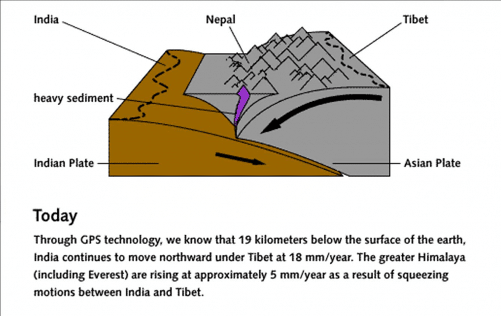
- India’s plate speed today is about 5 cm a year, an often-quoted figure. Only part of it is taken up in the Himalaya: GPS gives about 18–20 mm a year of shortening across the range.
- Erosion then carved the folded sediments into the present-day relief.
- The Tibetan Plateau rose through the upthrusting of the southern block of the Eurasian Plate.
- The Indo-Gangetic plain is built of alluvium brought down by rivers flowing from the Himalaya.
- The southward-bulging arc is explained by the strongest push coming at the two ends of the Peninsula as it drifted.
- The Aravalli in the north-west and the Assam ranges in the north-east acted as extended arms, while the central part sagged.
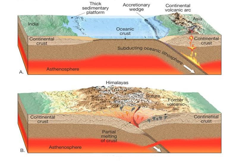
How the Plate Account Explains It
- Plate tectonics grew from the work of Harry Hess (1960), Robert Dietz (1961), W. Jason Morgan and Xavier Le Pichon (1968).
- A plate is a segment of lithosphere about 100 km thick, floating on the asthenosphere and moving independently.
- Three boundary types:
| Boundary | Also called | Movement | Result |
|---|---|---|---|
| Constructive | Diverging margin | Plates move apart | New crust |
| Destructive | Converging margin | Plates meet, one goes under | Crust consumed; fold mountains |
| Conservative | Transform margin | Plates slide past | Crust neither made nor lost |
- The Himalaya stands on a converging boundary, the Asian plate to the north and the Indian plate to the south. Lateral pressure squeezed the marine sediment on the bed of the Tethys.
- Older accounts say India began its approach about 70 million years ago, went under because it was the denser plate, and that the range was more or less complete by 10 million years ago. The growth of the range in fact runs on to the present.
- Crustal shortening: the classical estimate is about 500 km in the Himalaya, offset by sea-floor spreading in the Indian Ocean.
- The Main Central Thrust alone took up 140 km to over 500 km. India has driven 1,000–2,000 km into Eurasia since collision.
- The future: as India keeps moving, the fracture at the outer edge of the Shiwaliks stays active. Geologists expect the deformation to move out into the Ganga basin in time, pushing its rivers further south.
Is the Himalaya Still Rising?
- Heights fixed by trigonometrical survey suggested continuing rise. Henry Godwin-Austen estimated the average elevation at 2,440 m a million years ago, against 3,050 m now.
- The Mahabharat range is held to be rising especially vigorously.
- Four lines of evidence:
- Fossils: some Shiwalik fossil forms also occur in Tibet, so the two once shared a climate and a similar elevation.
- Tibetan lakes: sand and gravel terraces 60–100 m above present levels show the water once stood far higher, and the region has dried out as it rose.
- Earthquakes: their frequency shows the range has not reached isostatic equilibrium.
- Rivers: still youthful, rejuvenated in recent times, with terraces on the valley sides.
- The rate: older estimates of 5–10 cm a year are far too high. Measured rates are a few millimetres a year, and the diagram closing Phase 6 gives about 5 mm for the Greater Himalaya.
- Erosion also feeds uplift. A 2024 study links 15–50 m of Everest’s height to isostatic rebound after the Arun river captured its upper basin about 89,000 years ago.
- Everest’s official height is now 8,848.86 m, set jointly by Nepal and China in December 2020.
Phases of Himalayas Formation
- The Himalaya is not a single range but at least three, running more or less parallel. Hence its uplift is described in phases, and the count depends on the account.
- Three-phase classical scheme: the Great Himalaya from about 120 million years ago, by some views complete by 70; the Middle Himalaya 25–30 million years ago; the Shiwaliks 20–2 million years ago.
- The movements are traced from the late Cretaceous through the Eocene, Middle Miocene and Pliocene to the upper Pleistocene and sub-Recent.
- Six-phase scheme, followed below, gives more of the plate story:
- Phase 1: 100 million years ago
- Phase 2: 71 million years ago
- Phase 3: the Dras volcanic arc
- Phase 4: Greater Himalaya raised
- Phase 5: rise of the Lesser Himalaya
- Phase 6: rise of the Shiwalik ranges
- The table sets each date beside the current one.
| Phase | Older date | Current dating |
|---|---|---|
| India’s fast drift | 100 million years ago | Fastest in the late Cretaceous and Paleocene |
| Collision | 71 million years ago | About 65–59 million years ago |
| Dras arc | Oligocene | Mainly 125–84 million years ago, ended about 53 |
| Greater Himalaya, Main Central Thrust | 30–35 million years ago | Burial from about 50; thrust active about 23–18 |
| Lesser Himalaya, Main Boundary Thrust | 15–20 million years ago | Thrust from about 11–10 |
| Shiwaliks, Himalayan Frontal Fault | 2–20 million years ago | Frontal thrust from about 4–2.5, still active |
- The pattern is what matters: deformation migrated south over time, from the suture to the Main Central Thrust, then the Main Boundary Thrust, then the frontal thrust.
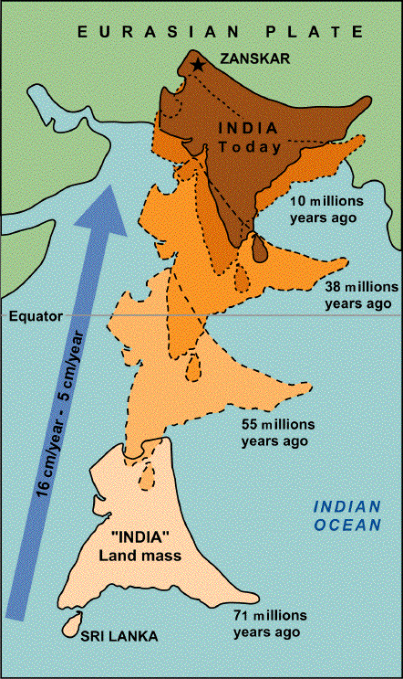
Phase 1: 100 Million Years Ago
- In the Cretaceous, about 100 million years ago, the Indian plate lay between 10°S and 40°S.
- The old claim that it then sat over the Réunion hotspot is out of date. India crossed the Marion plume about 90 million years ago and Réunion about 65 million years ago, the time of the Deccan Trap.
- Its maximum velocity is usually tied to its approach to the equator, at about 14 cm a year in older figures.
- Reconstructions give 18–20 cm a year in the late Cretaceous, with thin lithosphere and the plume as the favoured explanations.
- It slowed to about 5 cm a year after collision.
- Squeezing of the Tethys began towards the end of the Paleocene.
Phase 2: 71 Million Years Ago
- Himalayan orogenesis is dated in older accounts to about 71 million years ago, when the plate with its Gondwana piece drifted north-east and its rigid north-western flanks, of the Aravalli series, met Eurasia.
- The date fits India’s position in the figure above but not contact itself, which came later.
- The old view has closure running west to east. Recent dating finds contact almost synchronous, or starting in the central Himalaya.
- The line of collision between the Tibetan Plateau and the Indian Plate is the Indus–Tsangpo Suture Zone (ITSZ), a compressional tectonic fault line.
- As the plate went under, crustal doubling raised Tibet into a high plateau, with crust about 60 km thick. Seismic work gives about 73 km under the Tethyan Himalaya.
- South of the suture, the Murree foredeep formed, and further south the Shiwalik foredeep.
- Orogenesis is the formation of mountains, and orogeny is the process that forms them.
- A suture zone is a linear belt of intense deformation where terranes with different plate, metamorphic and palaeogeographic histories are joined.
Phase 3: The Dras Volcanic Arc
- In the Tethys crust, a chain of volcanic eruptions built the Dras arc.
- Its old placing in the Oligocene is too young. Zircon ages show a long-lived island arc, starting about 160 million years ago, peaking at 125–84 million years and ending about 53 million years.
- In the older scheme the plate began an anticlockwise rotation, with Dras as the pivotal axis.
- In the west, pressure and compression eased.
- In the east, squeezing of the Tethyan sediments began, which marks the start of the rise of the Tethyan belt.
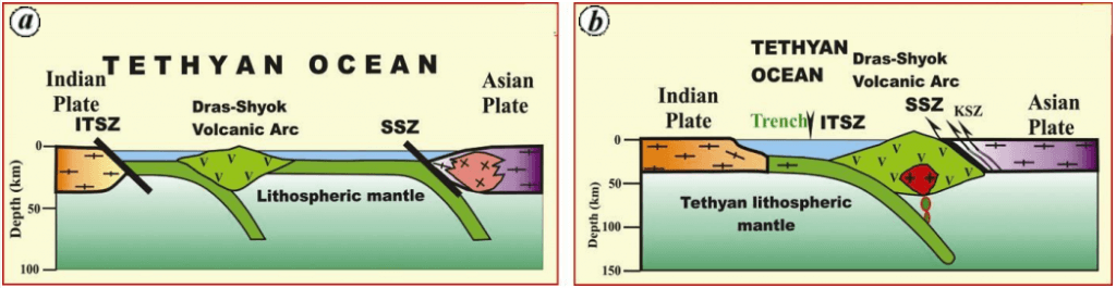
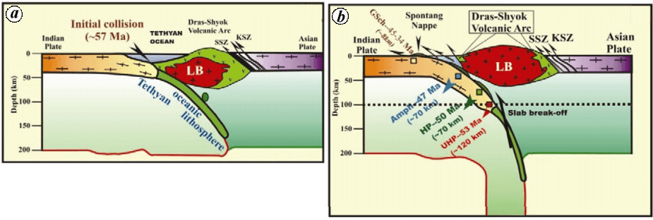
- In these sections, SSZ is the Shyok Suture Zone, KSZ the Karakoram Shear Zone and LB the Ladakh Batholith. They give collision at about 57 million years ago, close to the current range.
Phase 4: Greater Himalaya Raised
- As rotation continued, stronger compression drove a major thrust through the sediments of the Murree foredeep and raised the Greater Himalaya, placed at 30–35 million years ago in the Eocene to Oligocene in the older scheme.
- Its rocks were buried and heated from about 50 million years ago. The thrust itself moved mainly about 23–18 million years ago.
- This compressional thrust line is the Main Central Thrust (MCT).
Phase 5: Rise of the Lesser Himalaya
- Sediment kept reaching the Shiwalik foredeep. Further plate movement raised the Lesser Himalaya during the Miocene, 15–20 million years ago.
- The MCT separates the Greater and Lesser Himalaya. The thrust line that lifted the Lesser Himalaya is the Main Boundary Thrust or Fault (MBT or MBF), which began to slip about 11–10 million years ago.
Phase 6: Rise of the Shiwalik Ranges
- Himalayan rivers filled the Shiwalik foredeep with molasse, the coarse debris of a rising range.
- Partial folding of that fill along the Himalayan Frontal Fault (HFF) raised the Shiwaliks, a partly folded sedimentary range.
- This tectonic history is the key to the relief and structure that follow.
Relief and Structure of Himalayas
- From north to south:
- Tibetan Plateau
- Indus–Tsangpo Suture Zone
- Tethyan Himalaya
- Greater Himalaya
- Main Central Thrust
- Lesser Himalaya
- Main Boundary Fault
- Shiwaliks
- Himalayan Frontal Fault
- Indo-Gangetic basin
- Tibetan Plateau
- This is the geological or tectonic division. The ranges as relief units and the regional sections along the arc are separate ways of dividing the same mountains.
- The thrusts in one view:
| Line | Separates | Dip and character | Began |
|---|---|---|---|
| ITSZ | India and Asia | Collision zone, ophiolites | About 65–59 Ma |
| South Tibetan Detachment | Tethyan and Greater Himalaya | North-dipping shear zone | About 23–17 Ma |
| MCT | Greater and Lesser Himalaya | Low-angle reverse fault | About 23–18 Ma |
| MBT | Lesser Himalaya and Shiwaliks | Steeper reverse fault | About 11–10 Ma |
| HFF or Main Frontal Thrust | Shiwaliks and plain | Youngest, active | About 4–2.5 Ma |
- All three southern thrusts join at depth in the Main Himalayan Thrust, the gently north-dipping base of the wedge.
- It runs about 2,400 km, slips at about 17–21 mm a year, and is the source of the great Himalayan earthquakes, such as Kangra 1905 and Bihar–Nepal 1934.
Tibetan Plateau
- It is not part of the Himalaya but was formed by the Himalayan orogeny.
Indus–Tsangpo Suture Zone
- A compressional fault line running from the Indus gorge to the Tsangpo gorge, often given as about 3,200 km. Its southern Tibet stretch alone is about 2,000 km.
- It marks the zone of plate collision, with crushed and pulverised rock.
- Older accounts call these rocks mostly Palaeozoic and ancient. The zone is better known for ophiolites, mélange and flysch, remnants of the Neotethys floor, along with arc rocks and later molasse.
- The Indus and the Tsangpo now flow along this reverse-faulted line of discontinuity. A suture is the line where two plates weld.
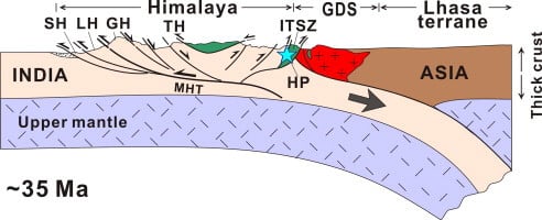
- In this section, SH, LH, GH and TH are the Sub-, Lesser, Greater and Tethyan Himalaya, and MHT the Main Himalayan Thrust.
Tethyan Himalaya
- Average height about 4,000 m.
- It is pressed against the Greater Himalaya. The lack of a longitudinal valley between them reveals the strong compression that sandwiched them.
- Rocks: submarine sedimentary and metamorphic, late Precambrian to Palaeozoic and Permian to Cretaceous margin sequences.
- It represents the first uplift of the Tethyan geosyncline or Murree foredeep.
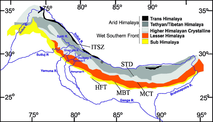
- On this map, STD is the South Tibetan Detachment, MCT the Main Central Thrust, MBT the Main Boundary Thrust and HFT the Himalayan Frontal Thrust.
Greater Himalaya
- Average height about 6,000 m.
- It extends from Namcha Barwa to Nanga Parbat for about 2,500 km.
- It is the mightiest mountain range of the world, with hundreds of peaks above 7,000 m.
- Relief: high relief, deep gorges, near-vertical slopes, a symmetrical curve convex to the south, and antecedent drainage.
- Peaks are sharp and valley walls stand as free faces, because of isostatic adjustment and deep valley cutting.
- Rocks: metamorphic and sedimentary, with a granite batholith core marking the intrusion of granitic magma, from partial melting of the thickened crust.
- Structure: asymmetrical folds from high compression. The eastern part has fractured rock, because the Indian Plate closed the Tethys there like a door slamming shut.
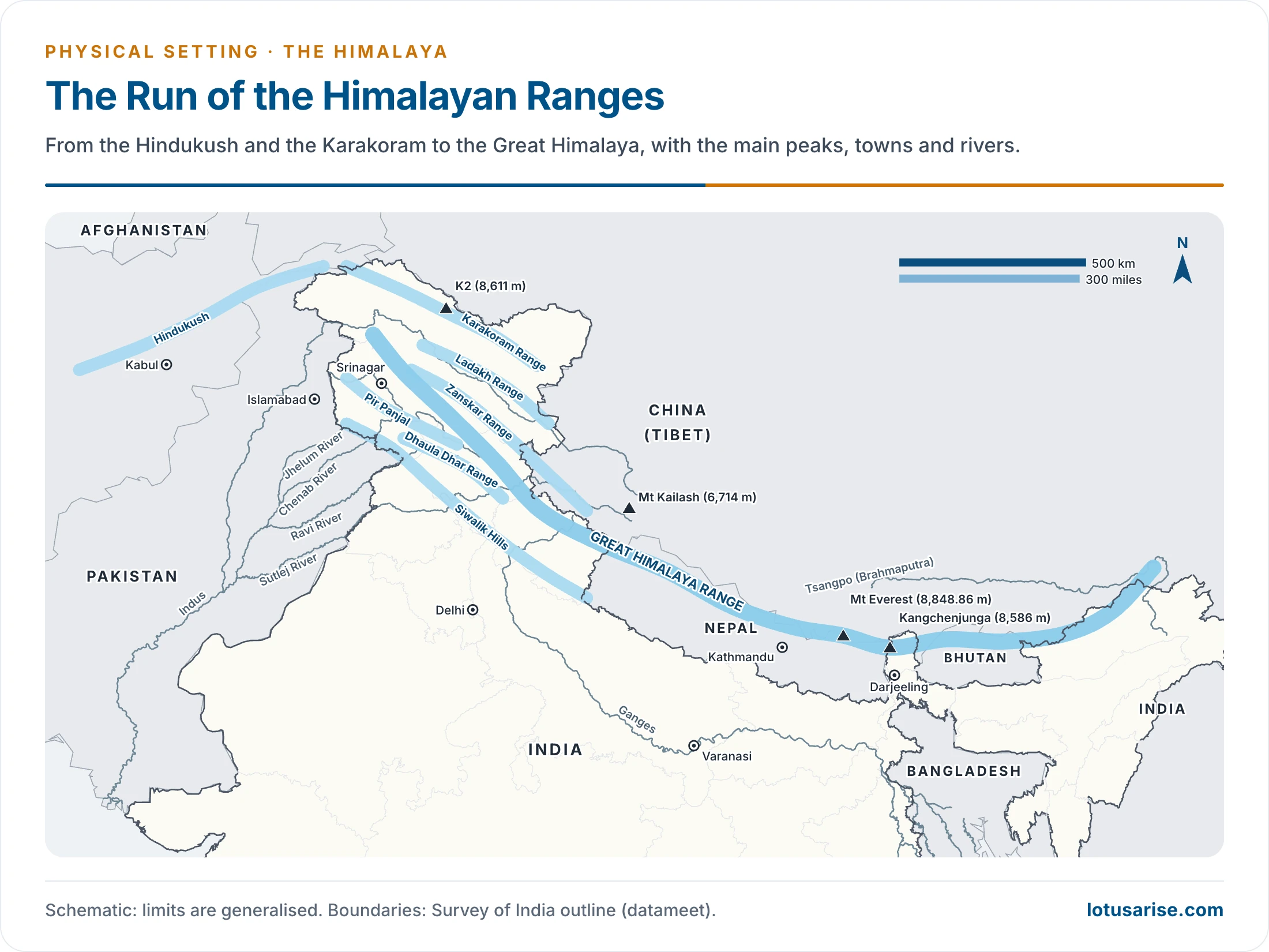
- Jammu and Kashmir, Ladakh and Arunachal Pradesh are parts of India. Everest stands at 8,848.86 m and Kangchenjunga at 8,586 m.
Main Central Thrust (MCT)
- The zone of tectonic thrust and the longitudinal axis along which the Greater Himalaya was lifted.
- It is a tectonic compressional valley of fractured and pulverised rock, forming a synclinal basin between the Greater and Lesser Himalaya.
- Examples of the synclinal basin: the Kathmandu, Kashmir, Kullu and Kangra valleys.
- Kullu is a transverse valley, while Kangra and Manali are straight or strike valleys.
- These valleys are more prone to earthquakes because of the faults beneath.
Lesser Himalaya
- Average height about 3,800 m; length about 2,400 km. It runs almost parallel to the Greater Himalaya, but in the west it breaks into several ranges.
- Parallel ranges: Pir Panjal, Dhaola Dhar.
- Transverse ranges: Ratan Pir, Nag Tibba, Mussoorie.
- In Nepal it is the Mahabharat range. In the east it takes the names Dafla, Mishmi, Miri and Abor hills, closely pressed against the Shiwaliks and hard to separate from them.
- There the Himalaya is much narrower than in the west, and the structure is complex, with fractures, faults and pulverised rock.
Main Boundary Fault (MBF)
- The longitudinal axis of the second major thrust, also a compressional fault line and shallower at the surface than the MCT.
- The MCT is a low-angle reverse fault and the MBF a wide-angle one, and so the valleys here are wide.
- Rivers ponded in these valleys and left lacustrine sediment.
- Once they cut through the Shiwaliks, the lake beds were left as alluvial flats, the Doons, for example Dehra Dun and Patli Dun.
- Longitudinal valleys between the Lesser Himalaya and the Shiwaliks are Doons in the western and central Himalaya and Duars in the eastern Himalaya.
Shiwaliks
- Average height about 800–1,200 m.
- Partly folded, of river sediment laid in the foredeep.
- They show hogback topography, and the 300 m contour marks their boundary with the Gangetic plain.
- Names along the arc: Shiwalik in the west; Churia Ghat hills (Churiaghat) in Nepal; Mishmi, Abor and Dafla hills in Assam and Arunachal Pradesh, the same names as the Lesser Himalaya there.
- In Nepal they come very close to the higher ranges. The belt thins east of the Gandak and is almost lost there, rather than ending at the Ganga as is sometimes said.
Himalayan Frontal Fault (HFF)
- It marks the boundary between the Himalayan ranges and the Gangetic basin.
- Described as a wide-angle thrust line, it took the last compressional force of the orogeny and is now the most active surface fault of the range.
Indo-Gangetic Basin
- The foredeep in front of the mountains, filling with Himalayan sediment, is the last unit of the section. Its regional divisions are a landform topic of their own.
Previous Year Questions
2025“The Himalaya is still rising.” Expand this statement and describe the processes involved in it with suitable sketches and diagrams.2014State the concept of plate tectonics. How does it help in explaining the formation of the Himalayas and the Appalachian Mountains?2010Explain Himalayan Orogeny and illustrate how the process has affected the geomorphic characteristics of Macro divisions of Himalayas.2007Explain the different views put forth about the origin of Himalayas and divide Himalayas into vertical divisions.1999Explain the rise of the Himalayan ranges.1995Draw a sketch-map in your answer book to delineate the main physiographic regions of India and provide a reasoned account of the relief and structure of the Himalayan region.1988Explain the salient features of the structure, relief and drainage of the Himalayas.





Good Content .. if PDF avail would be good
Buy his course and you will get it . This person is helping us a lot so least we can do is buying his courses which are so economical compare to this material’s quality … we have to understand that one cannot run free website for long if we can’t provide atleast minimal amount of fee for his work by purchasing his work
This content is simiar to PMF
blog content is really good….. Really enjoyed of reading it.
Love this content…Useful and easily understandable contenet…Keep it up sir…
useful content
I like this…really helpful congrats to Lotusarise team
this is the best and very comprehensive yet brief explanation. Thank you so much. It helped me tremendously.
Sir,in NCERT it’s written that Indian plate density is more, and it’s subducting.
Yup, recent data shows that Indian plate is subducting under Eurasian plate
thank u for writing this content its helping me in my exams…
Keep reading, and Keep Supporting Guys👍.