

State the concept of plate tectonics. How does it help in explaining the formation of the Himalayas and Appalachian Mountains? (2014)
The concept of plate tectonics
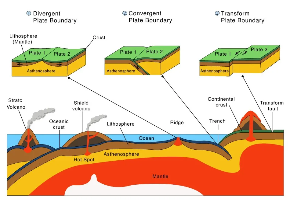
- The lithosphere — crust plus the rigid upper mantle, roughly 100 km thick — is broken into about seven large and many smaller plates that move over the weak, partly molten asthenosphere at a few centimetres a year.
- Plates interact only at their edges:
- divergent boundaries create new oceanic lithosphere at mid-ocean ridges;
- convergent boundaries consume it at trenches (subduction) or crumple continents together (collision);
- transform boundaries let plates slide past each other.
- Oceanic lithosphere is dense (basaltic crust ~3.0 g/cm³) and sinks at trenches; continental crust (~2.7 g/cm³) is too buoyant to subduct far, so when two continents meet the crust thickens instead — which is why collisions build the highest ranges.
- Drivers: mainly slab pull of cold, sinking oceanic lithosphere, helped by ridge push and mantle convection.
- Foundations: sea-floor spreading (Harry Hammond Hess, 1962); magnetic stripes (Frederick Vine and Drummond Matthews, 1963); transform faults (John Tuzo Wilson, 1965); the full kinematic theory (Dan McKenzie, Robert Parker, William Jason Morgan, Xavier Le Pichon, 1967–68). GPS now measures plate motion directly.
- Wilson cycle: oceans open, widen, are subducted and close, and their margins collide — John Tuzo Wilson (1966) inferred it from the Appalachian–Caledonian belt. This cycle links the two ranges in the question.
The Himalaya — a collision still in progress
Stage 1: Ocean–continent subduction
- After Gondwana broke up in the Cretaceous, India drifted north while the Neo-Tethys ocean floor subducted beneath Asia.
- That Andean-type margin left the Trans-Himalayan (Ladakh–Gangdese) batholiths — the root of an old volcanic arc.
Stage 2: Collision
- Once the ocean closed, buoyant Indian continental crust could not sink. The join is the Indus–Tsangpo Suture Zone, lined with ophiolites — slices of Tethyan ocean floor (e.g. Spontang and Nidar in Ladakh).
- Timing is debated:
- sediment dating by Wei An, Xiumian Hu, Eduardo Garzanti and colleagues (2021) places the start of collision at about 61 million years ago;
- some palaeomagnetic studies argue for a smaller “Greater India” and a later, Eocene contact around 50 million years ago.
Stage 3: Shortening and thickening
- India keeps pushing north at roughly 4–5 cm a year. Its crust is scraped off and stacked in south-propagating thrust sheets (Tethyan, Greater, Lesser Himalaya, Siwaliks), the Tethyan sediments are folded, and the crust has thickened to about twice normal. The summit rock of Everest is Ordovician marine limestone — former sea-floor sediment now near 8,849 m.
- Current refinement: receiver-function imaging by Lin Liu, Danian Shi and Simon L. Klemperer (2025) shows the Indian plate tearing:
- west of ~90°E intact Indian lithosphere is underplating Tibet;
- farther east its mantle part is peeling away (delaminating) from the crust.
- Collision is therefore not one uniform slab advancing, but a segmented plate.
- Active thrust faults, great earthquakes and high relief all follow directly: the Wilson cycle here is at the collision stage, still running.
The Appalachians — a completed cycle
Opening and closing of Iapetus
- After the Grenville orogeny (~1.1 billion years ago, assembly of Rodinia), rifting opened the Iapetus Ocean beside ancestral North America (Laurentia).
- Its closure built the range in three main collisions:
- Taconic (ending ~440 million years ago) — volcanic island arcs accreted to Laurentia;
- Acadian (from ~375 million years ago) — collision with the Avalonian microcontinental fragments;
- Alleghanian (~325–260 million years ago) — collision with Africa (Gondwana), forming Pangaea and the folded, thrust Valley and Ridge belt.
Reopening as the Atlantic
- From roughly 200 million years ago Pangaea rifted. Rift basins such as the Newark Basin record it, and the Atlantic opened beside the old suture.
- The dead orogen was left inside a passive margin, with no active plate boundary.
- Proof of the cycle: the belt continues into the Caledonides of Scotland and Norway and the Variscan–Mauritanide belts of Europe and north-west Africa — one range split by the Atlantic.
Why it is low, and why not lower
- Over 250 million years of denudation have reduced it to rounded ridges (highest point Mount Mitchell, 2,037 m) with little seismicity — the classic residual fold mountain.
- Yet relief there has grown again in the Cenozoic:
- Scott R. Miller, Peter B. Sak, Eric Kirby and Paul R. Bierman (2013) found Neogene rejuvenation of central Appalachian topography in stream profiles and erosion rates;
- Lijun Liu (2014) attributed ~400 m of new relief to continental tilting by the sinking Farallon slab deep in the mantle.
- The cause is still argued — mantle-driven or erosional — but plate and mantle processes still act on the range long after its collision ended.
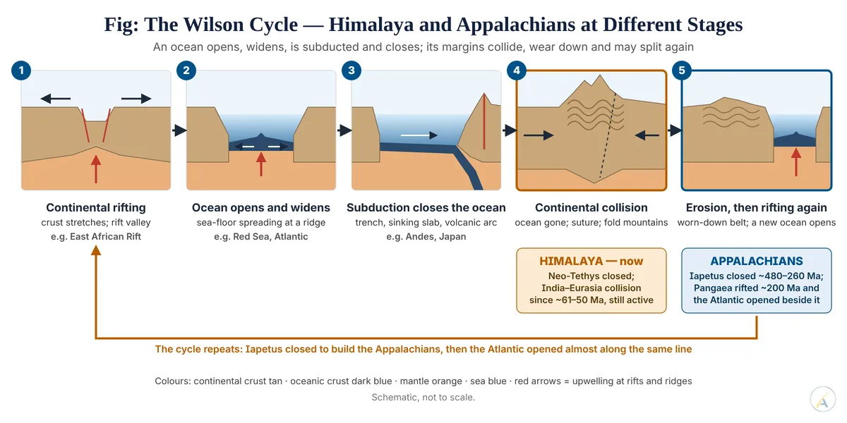
How plate tectonics explains both
| Criterion | Himalaya | Appalachians |
|---|---|---|
| Ocean closed | Neo-Tethys | Iapetus |
| Colliding masses | India – Eurasia | Laurentia with arcs, Avalonia, Gondwana-Africa |
| Timing | collision since ~61–50 Ma, ongoing | ~480–260 Ma, ended |
| Wilson-cycle stage | collision in progress | post-collision; ocean reopened (Atlantic) |
| Relief and activity | highest, rising, seismically active | low, denuded, largely quiet |
- Earlier fixist and contraction theories could not explain an ocean-floor suture with ophiolites, a volcanic arc predating collision, or a mountain belt split across an ocean; plate tectonics explains all three in both ranges.
- Judgement: plate tectonics explains the Himalaya and the Appalachians as the same process at different stages — one ocean closing now, another closed and reopened long ago. Live debates over collision timing, slab tearing and Appalachian rejuvenation refine the details without weakening the core explanation.