In this article, You will read Divisions of Indo Gangetic Plains i.e. Indo-Gangetic-Brahmaputra Plains for UPSC IAS.
Indo Gangetic Plains
- The 300m contour line divides the Himalayas and the Gangetic Basin.
- The southern boundary is demarcated by the edge of the peninsula which coincides with 75m contours in most of its length and 35m in the northeastern section, towards the delta.
- The plains are extremely flat with a slope of nearly 1:1000 to 1:2000
- The plains are flat and are rolling with monotonous character.
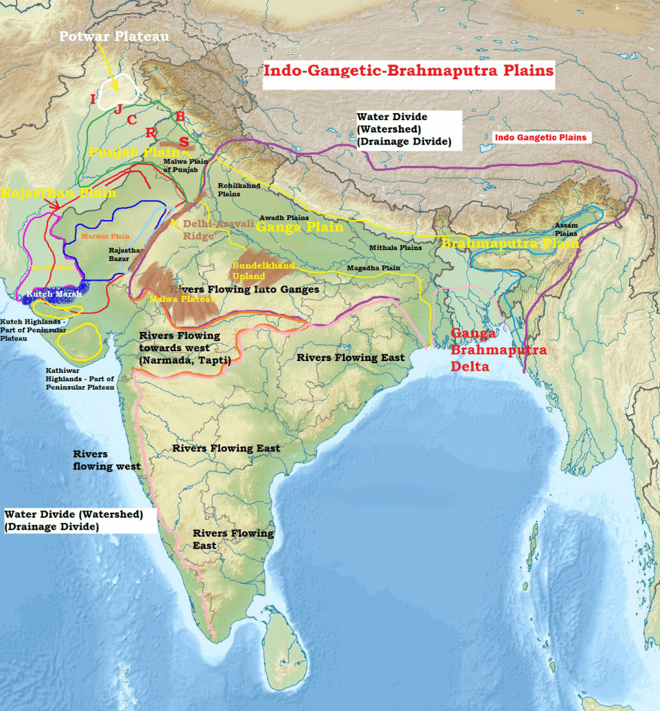
Formation of Indo–Gangetic–Brahmaputra Plain
- The formation of Indo-Gangetic plain is closely related to the formation of Himalayas.
- The rivers which were previously flowing into the Tethys sea (Before Indian Plate collided with Eurasian Plate – continental drift, plate tectonics) deposited a huge amount of sediments in the Tethys Geosyncline.
- The Himalayas are formed out of these sediments which were uplifted, folded, and compressed due to the northern movement of the Indian Plate.
- The northern movement of the Indian Plate also created a trough to the south of the Himalayas.
Depositional Activity
- During the initial stages of upliftment of sediments, the already existing rivers changed their course several times and they were rejuvenated each time (perpetual youth stage of rivers.
- The rejuvenation is associated with intense headward and vertical downcutting of the soft strata overlying the harder rock stratum.
- Headward erosion and vertical erosion of the river valley in the initial stages, lateral erosion in later stages contributed a huge amount of conglomerates (detritus)(rock debris, silt, clay, etc.) which were carried downslope.
- Headward erosion — Erosion at the origin of a stream channel, which causes the origin to move back away from the direction of the streamflow, and so causes the stream channel to lengthen
- These conglomerates were deposited in the depression (Indo-Gangetic Trough or Indo-Gangetic syncline) (the base of the geosyncline is hard crystalline rock) between peninsular India and the convergent boundary (the region of present-day Himalayas).
New rivers and more alluvium
- The raising of the Himalayas and the subsequent formation of glaciers gave rise to many new rivers. These rivers along with glacial erosion supplied more alluvium which intensified the filling of the depression.
- With the accumulation of more and more sediments (conglomerates), the Tethys sea started receding.
- With the passage of time, the depression was completely filled with alluvium, gravel, rock debris (conglomerates) and the Tethys completely disappeared leaving behind a monotonous aggradational plain.
- monotonous == featureless topography;
- aggradational plain == plain formed due to depositional activity.
- Indo-Gangetic plain is a monotonous aggradational plain formed due to fluvial depositions.
- Upper peninsular rivers have also contributed to the formation of plains, but to a very small extent.
- During recent times (since few million years), depositional work of three major river systems viz., the Indus, the Ganga, and the Brahmaputra have become predominant.
- Hence this arcuate (curved) plain is also known as Indo-Gangetic-Brahmaputra Plain.
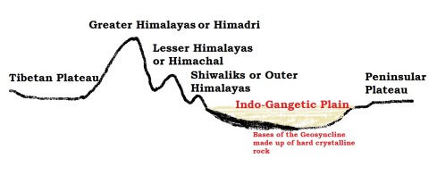
Longitudinal Profile – Indo Gangetic Plains
- Bhabhar
- Tarai
- Bangar
- Khadar
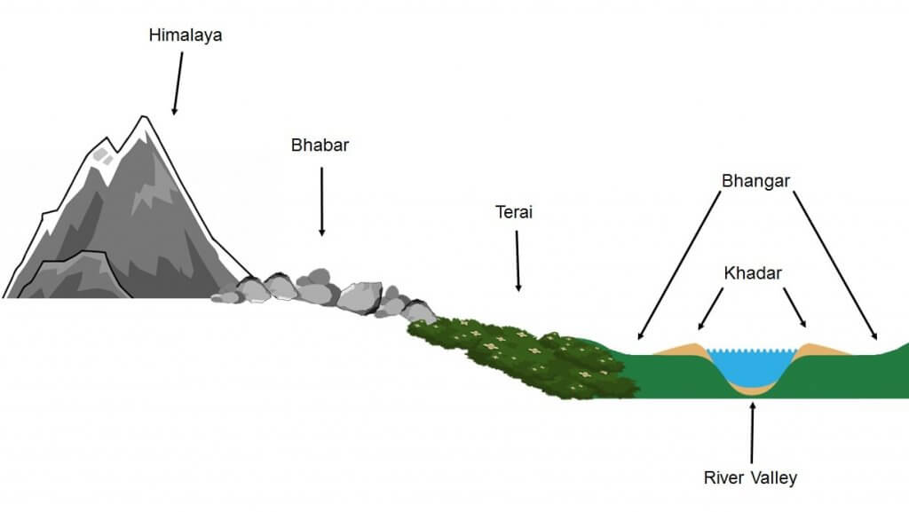
Bhabhar Region
- Adjacent to Shiwalik foothills, coarser materials like cobbles, pebbles, gravels, boulders with coarse sand.
- It is a narrow, porous, northernmost stretch of the Indo-Gangetic plain.
- It is about 8-16 km wide running in an east-west direction along the foothills (alluvial fans) of the Shiwaliks.
- They show a remarkable continuity from the Indus to the Tista.
- Rivers descending from the Himalayas deposit their load along the foothills in the form of alluvial fans.
- These alluvial fans have merged together to build up the bhabar belt.
- The porosity of bhabar is the most unique feature.
- The porosity is due to the deposition of a huge number of pebbles and rock debris across the alluvial fans.
- The streams disappear once they reach the bhabar region because of this porosity.
- Therefore, the area is marked by dry river courses except in the rainy season.
- The Bhabar belt is comparatively narrow in the east and extensive in the western and north-western hilly region.
- Bhabhar zones stretches from Punjab to Assam Himalayas
- It has a complex profile and general slope of 1:6000
- The area is not suitable for agriculture and only big trees with large roots thrive in this belt.
Terai Plains
- Marshy near the Bhabhar zone, extremely flat marshy lands, densely deforested and parallel to the mountains from Punjab to Assam
- Terai is an ill-drained, damp (marshy) and thickly forested narrow tract to the south of Bhabar running parallel to it.
- The Terai is about15-30 km wide.
- Widest along Bihar and eastern UP and the narrowest in the east.
- The underground streams of the Bhabar belt re-emerge in this belt.
- The Terai is more marked in the eastern part than in the west because the eastern parts receive a comparatively higher amount of rainfall.
- Most part is deforested for agriculture.
- Tarai soils are Nitrogen-rich and have a humus content
- Most of the Terai land, especially in Punjab, Uttar Pradesh, and Uttarakhand, has been turned into agricultural land which gives good crops of sugarcane, rice, and wheat.
Bangar Region
- It extends over the whole Gangetic plain.
- The Bhangar is the older alluvium along the river beds forming terraces higher than the flood plain.
- The terraces are often impregnated with calcareous concretions known as ‘KANKAR’.
- ‘The Barind plains’ in the deltaic region of Bengal and the ‘bhur formations’ in the middle Ganga and Yamuna doab are regional variations of Bhangar.
- Bhur denotes an elevated piece of land situated along the banks of the Ganga river especially in the upper Ganga-Yamuna Doab. This has been formed due to the accumulation of wind-blown sands during the hot dry months of the year.
- Bhangar contains fossils of animals like rhinoceros, hippopotamus, elephants, etc.
- It has Kankar deposits which are fragments of Limestone, thus natural supplements of bases to the soil.
- It has been seriously degraded in several parts of UP where it is called Usar (Infertility due to salinization) are very less.
Barind Tract (Barind Plains)
- Barind Tract (alternately called the Varendra Tract in English and Borendro Bhumi in Bengali) is the largest Pleistocene era physiographic unit in the Bengal Basin. Barind Tract is the geographic region in parts of northwestern Bangladesh and north-central West Bengal state, India.
- It lies northwest of the confluence of the upper Padma (Ganga) and Jamuna (the name of the Brahmaputra in Bangladesh) rivers and is bordered by the floodplains of the Mahananda River to the west and the Karatoya River to the east—tributaries of the upper Padma and of the Jamuna, respectively.
- Barind is a comparatively high, undulating region, with reddish and yellowish clay soils.
- It has long been recognized as a unit of old alluvium.
Khadar Region
- The Khadar is composed of newer alluvium and forms the flood plains along the river banks.
- A new layer of alluvium is deposited by river flood almost every year.
- This makes them the most fertile soils of Ganges.
Reh or Kollar
- Reh or Kollar comprises saline efflorescences of drier areas in Haryana.
- Reh areas have spread in recent times with an increase in irrigation (capillary action brings salts to the surface).
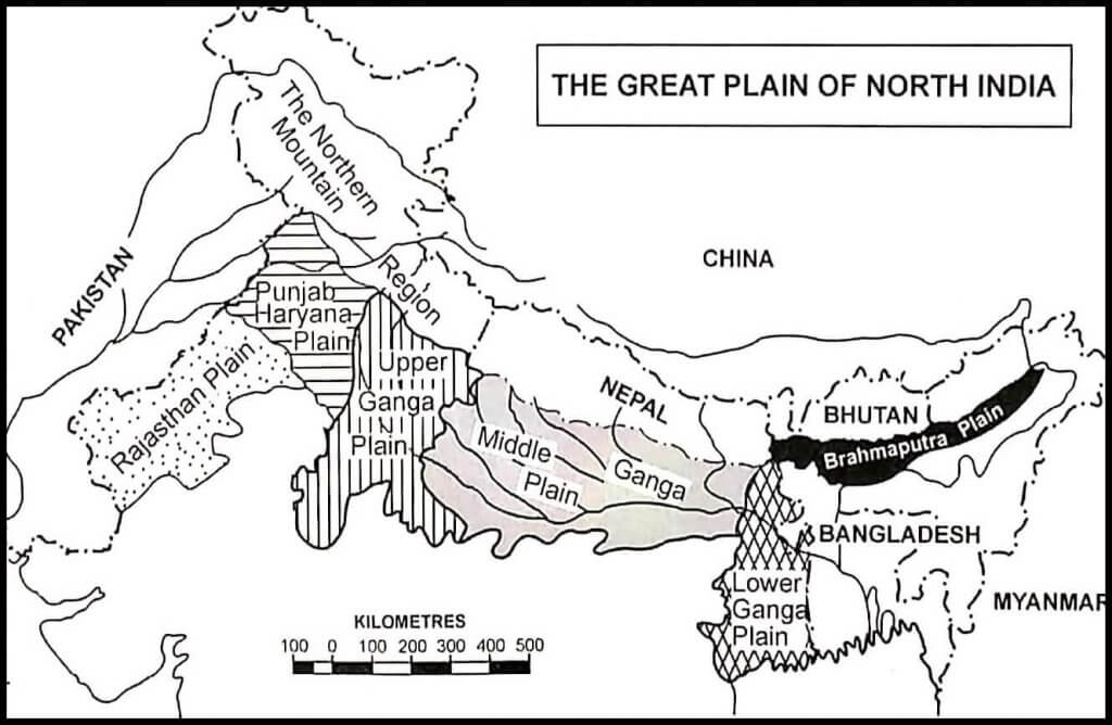
Transverse Profile – Indo Gangetic Plains
- Rajasthan Plains
- Punjab Plains
- Gangetic Plain
- Assam Plain (Brahmaputra Plain)
Rajasthan Plain
- The Ghaghar basin in North, Aravallis in East
- It is a part of the Thar desert but it has alluvial deposits of Indus and its tributaries
- In the wake of the Himalayas’ upliftment, these channels shifted to west.
- This plain is an undulating plain (wave-like) whose average elevation is about 325 m above mean sea level.
- 25cm isohyte divides the plain into marusthali in the west and Rajasthan Bagar in the east.
- Marusthali is a desert with shifting sand dunes called Dhrian.
- This entire Marushatli region receives a rainfall of 25cm and the only tree is Khejri (the Bishnoi tribe is associated with it).
- Rajasthan Bagar – It is semi-arid fertile tracts or green patches called ROHI.
- In the north of Luni, a sandy desert is known as THALI.
Saline Lakes
- North of the Luni, there is inland drainage having several saline lakes. They are a source of common salt and many other salts.
- Sambhar, Didwana, Degana, Kuchaman, etc. are some of the important lakes. The largest is the Sambhar lake near Jaipur.
Punjab Plain
- This plain is formed by five important rivers of the Indus system.
- The plain is primarily made up of ‘doabs’ —the land between two rivers.
- There are 5 doabs (Chaj, Rechna, Bist, Bari and Sindsagar).
- The depositional process by the rivers has united these doabs giving a homogenous appearance.
- Punjab literally means “(The Land of) Five Waters” referring to the following rivers: the Jhelum, Chenab, Ravi, Sutlej, and Beas.
- Extremely fertile plains but poor drainage and flood-prone.
- The total area of this plain is about 1.75 lakh sq km.
- The average elevation of the plain is about 250 m above mean sea level.
- It is bounded by 291m contour line running parallel to Delhi–Ambala ridge which separates it from the Gangetic basin.
- The eastern boundary of the Punjab Haryana plain is marked by subsurface Delhi-Aravali ridge.
- The northern part of this plain has been intensively eroded by numerous streams called Chos. This has led to enormous gullying.
- To the south of the Satluj river, there is Malwa plain of Punjab.
- The area between the Ghaggar and the Yamuna rivers lies in Haryana and often termed as ‘Haryana Tract’. It acts as a water-divide between the Yamuna and the Satluj rivers.
- The only river between the Yamuna and the Satluj is the Ghaggar which is considered to be the present-day Successor of the legendary Saraswati River.
Gangetic Plain
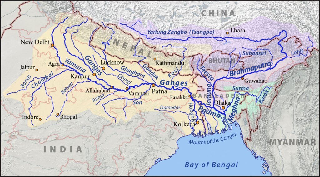
- This is the largest unit of the Great Plain of India stretching from Delhi to Kolkata (about 3.75 lakh sq km).
- The Ganga along with its large number of tributaries originating in the Himalayans have brought large quantities of alluvium from the mountains and deposited it here to build this extensive plain.
- The peninsular rivers such as Chambal, Betwa, Ken, Son, etc. joining the Ganga river system have also contributed to the formation of this plain.
- The general slope of the entire plain is to the east and south east.
- Rivers flow sluggishly in the lower sections of Ganges as a result of which the area is marked by local prominences such as levees, bluffs, oxbow lakes, marshes, ravines, etc. {Fluvial Landforms, Arid Landfroms}
- Almost all the rivers keep on shifting their courses making this area prone to frequent floods. The Kosi river is very notorious in this respect. It has long been called the ‘Sorrow of Bihar’.
Divisions of Ganga plains
- Upper Gangetic Plain
- Middle Gangetic Plain
- Lower Gangetic Plain
Upper Gangetic Plain
- 291m contour in the west, 300m contour in the North, 75m in South and 100m contour in east forms the boundary.
- It includes
- Rohilkhand Plains: Rohila Tribe (Afghan), Bareilly, Muzaffarnagar. It is very fertile. It has Sharda and Ramganga doabs
- Ganga-Yamuna Doab: Largest doab of India. It has fine dust deposits by the aeolian process. It is famous for sugarcane cultivation.
- Yamuna – Chambal Basin: Badland region because of gully erosions, ravines. The worst soil degraded area of India and largest degraded area.
Middle Gangetic Plain
- It is transitional plain par excellence. It is the most fertile tract of the world, which alone can sustain the major population of India.
- It includes 3 sections :
- Awadh Plain: B/w Ghaghra and Gomti, east UP, Flood Prone
- Mithila Plain: B/w Gandak and Kosi, Flood Prone
- Magadh Plain: Located east of R.Son, not flood-prone
- These transitional plains have perfect loam deposits and the groundwater level is very high
Lower Gangetic Plain
- Paradelta in North which is erosion bound looks like an inverted triangle, North part of WB
- Rarh Plains: Western section adjacent to Chota Nagour plateau, Laterite deposits. 35m contour line separates it from Chota Nagar Plateau
- Delta Plains: Most Extensive part of Sunderbans(1/3 in India). The braided channel, lakes, and marshes. It is famous for inland fishing and it is known for Jute cultivation. Sunderbans or Mangrove forests or Tidal Forests are located towards the coastline.
Ganga-Brahmaputra Delta
- This is the largest delta in the world.
- The Ganga river divides itself into several channels in the delta area. The slope of the land here is a mere 2 cm per km. Two-thirds of the area is below 30 m above mean sea level. [Highly vulnerable to sea-level changes]
- The seaward face of the delta is studded with a large number of estuaries, mud flats, mangrove swamps, sandbanks, islands, and forelands.
- A large part of the coastal delta is covered tidal forests. These are called the Sunderbans because of the predominance of the Sundri tree here.
Brahmaputra Plain
- This is also known as the Brahmaputra valley or Assam Valley or Assam Plain as most of the Brahmaputra valley is situated in Assam.
- Its western boundary is formed by the Indo-Bangladesh border as well as the boundary of the lower Ganga Plain. Its eastern boundary is formed by Purvanchal hills.
- It is an aggradational plain built up by the depositional work of the Brahmaputra and its tributaries.
- The innumerable tributaries of the Brahmaputra river coming from the north form a number of alluvial fans. Consequently, the tributaries branch out in many channels giving birth to river meandering leading to the formation of the bill and ox-bow lakes.
- There are large marshy tracts in this area. The alluvial fans formed by the coarse alluvial debris have led to the formation of terai or semi-terai conditions.
Significance of the Plain
- This one-fourth of the land of the country hosts half of the Indian population.
- Fertile alluvial soils, flat surface, slow-moving perennial rivers, and favorable climate facilitate intense agricultural activity.
- The extensive use of irrigation has made Punjab, Haryana, and the western part of Uttar Pradesh the granary of India (Prairies are called the granaries of the world).
- The entire plain except the Thar Desert has a close network of roads and railways which has led to large-scale industrialization and urbanization.
- Cultural tourism: There are many religious places along the banks of the sacred rivers like the Ganga and the Yamuna which are very dear to Hindus. Here flourished the religions of Budha and Mahavira and the movements of Bhakti and Sufism.

Gr@t
Hii this static content is enough for geography optional point of view please reply me as soon as, possible
Please reply me
hey on this platform geography optional notes also available plz check menu
Rarh plains are in the eastern side of chota Nagpur plateau, no?
This content gave me more knowledge about the plains this is very nice 👍👍👍