

“The Himalaya is still rising.” Expand this statement and describe the processes involved in it with suitable sketches and examples. (2025)
- The statement means that the India–Eurasia collision, which began in the Palaeocene–Eocene, has not ended: the Indian plate still converges with Eurasia, and the range is still being shortened, thickened and pushed up today.
- “Rising” needs care. Philip England and Peter Molnar separated three things: rock uplift (rock moving up), exhumation (erosion removing the cover) and surface uplift (mean ground level going up). The Himalaya shows abundant rock uplift; whether its mean height still grows is debated, because erosion removes rock almost as fast as tectonics raises it.
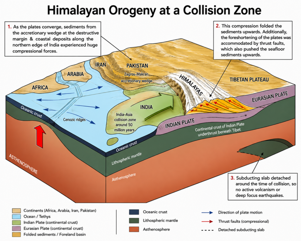
Evidence that uplift continues
- Geodesy: GPS shows India converging with Eurasia at roughly 4–5 cm a year; about 18–20 mm a year of this is absorbed across the Nepal Himalaya alone (Thomas Ader, Jean-Philippe Avouac and colleagues, 2012).
- Seismicity: great earthquakes — Bihar–Nepal 1934, Assam 1950, Gorkha 2015 — release strain on the same fault that builds the range.
- Geomorphic signals: uplifted and tilted river terraces along the Siwalik front; deep, young gorges cut by antecedent rivers (Indus, Sutlej, Arun, Brahmaputra) that kept pace with the rising range; rejuvenated youthful valleys.
- Tibetan lakes stand ringed by gravel terraces tens of metres above present water level, and Siwalik-type fossils occur on the now-high plateau — both read classically as evidence of recent uplift.
Process 1 — Underthrusting and crustal shortening
- India slides northward beneath the range along one gently dipping master fault, the Main Himalayan Thrust (MHT) — a décollement from which the major thrusts branch upward:
- Main Central Thrust (MCT) carries the Greater Himalayan crystallines over the Lesser Himalaya;
- Main Boundary Thrust (MBT) carries the Lesser Himalaya over the Siwaliks;
- Himalayan Frontal Thrust (HFT) — the youngest — folds and lifts the Siwalik foreland sediments.
- Deformation has migrated southward with time, so the Siwaliks are the newest part of the mountain wedge; this is shortening and crustal thickening (crust about twice normal thickness) in action.
- The South Tibetan Detachment at the top of the Greater Himalaya is a normal fault: the high wedge extends at its crest even while thrusting below lifts it.
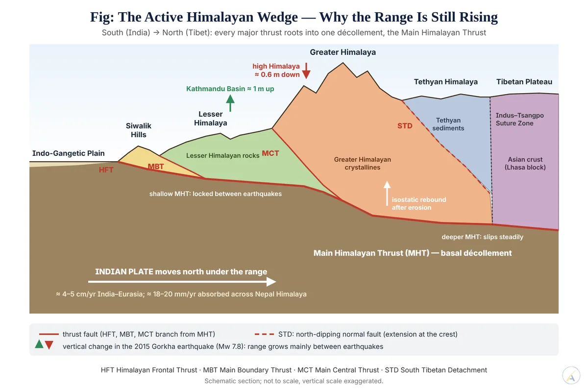
Process 2 — The earthquake cycle
- For centuries the shallow MHT stays locked; India keeps moving, so the overriding wedge bends, and the high range creeps upward between earthquakes.
- A great earthquake then releases the strain. The 2015 Gorkha earthquake (Mw 7.8) raised the Kathmandu Basin by about 1 m but let the high Himalaya farther north subside by about 0.6 m (John R. Elliott, Jean-Philippe Avouac and colleagues, 2016).
- Their reading: the high peaks grow mainly between earthquakes, as slip continues on the deeper, steeper ramp of the MHT — “still rising” is a long-run sum of slow rise and sudden drops.
- Earthquakes that break the surface on the HFT lift Siwalik anticlines in single steps, leaving uplifted terraces as their record.
Process 3 — Isostasy and erosion
- The range floats on a thick crustal root (Airy-type compensation). When rivers and glaciers strip mass away, the root rebounds and lifts the peaks — erosion lowers valleys but can raise summits.
- Tectonic aneurysm: at the Nanga Parbat and Namche Barwa syntaxes, intense gorge incision weakens the crust and focuses very rapid rock uplift (Peter K. Zeitler and colleagues, 2001); exhumation near Namche Barwa accelerated again in the last ~100,000 years (Rong Yang, Frédéric Herman and colleagues, 2021).
- Everest example (live debate):
- Xu Han, Jin-Gen Dai, Matthew Fox and colleagues (2024) argued that the Arun River captured a large Tibetan headwater about 89,000 years ago; the extra incision unloaded the crust, and isostatic rebound explains ~15–50 m of Everest’s anomalous height.
- Joel S. Leonard and Kelin X. Whipple (2026) replied that the Arun’s steep, disequilibrium profile is better explained by orographic rainfall than by river piracy.
- The rebound mechanism is sound physics; the specific capture trigger is unproven.
Limits to “rising”
- Gravitational spreading of thickened crust — the STD and north–south grabens such as the Thakkhola (Mustang) and those of southern Tibet — shows the orogen also collapses under its own weight.
- Measured uplift is millimetres a year, not centimetres; much of it is cancelled by erosion, so parts of the range may be near a steady state of rock uplift balanced by denudation.
- Judgement: the statement is sound — continuing convergence on the MHT, the earthquake cycle and isostatic rebound keep lifting Himalayan rock today — but the precise claim is that rock uplift outpaces or matches erosion, not that every peak grows steadily; the Everest river-capture debate shows that even the cause of a single summit’s height is still being contested.