

- India has about 1,382 identified offshore islands in the 2016 official list. A later Survey of India reconciliation gives 1,389 islands and islets in all, once offshore and inshore islands are separated.
- Two major groups stand out: the Andaman and Nicobar archipelago on the Bengal side and the Lakshadweep Islands on the Arabian Sea side.
- Other islands lie in the Ganga–Brahmaputra delta, where they are as much part of the delta as true islands, and between India and Sri Lanka, as remnants of Adam’s Bridge (Rama’s Bridge or Rama Setu), drowned by submergence.
- The two distant groups matter far beyond their size. They give India a long reach over the Indian Ocean sea lanes and a large exclusive economic zone.
The Two Island Groups
| Basis | Andaman and Nicobar | Lakshadweep |
|---|---|---|
| Sea | Bay of Bengal | Arabian Sea |
| Origin | Tectonic: plate collision, extension of the Arakan Yoma | Coral, on the Réunion hotspot trace |
| Number | 836 islands, islets and rocks (older 265) | 36 islands |
| Inhabited | 31 | 10 |
| Area | 8,249 sq km | 32 sq km |
| Relief | Mountainous; Saddle Peak 732 m | Flat; mostly under 5 m |
| Capital | Sri Vijaya Puram (Port Blair) | Kavaratti |
| Status | Union Territory | Union Territory, the smallest |
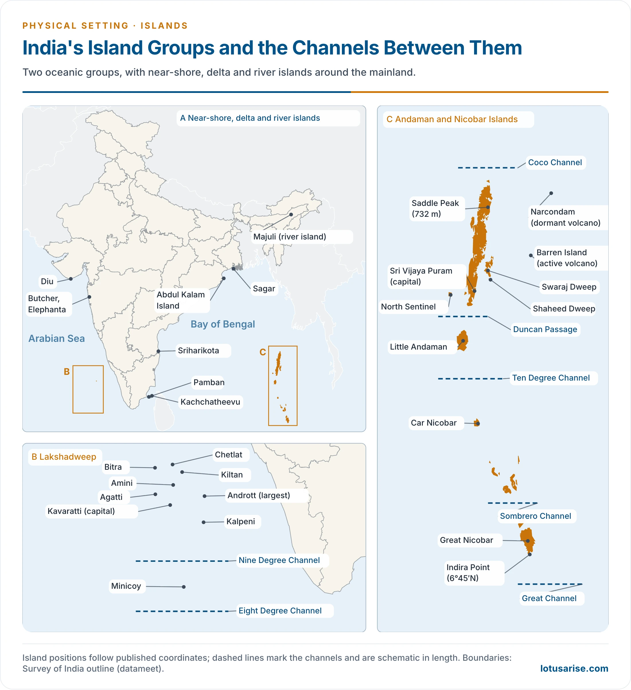
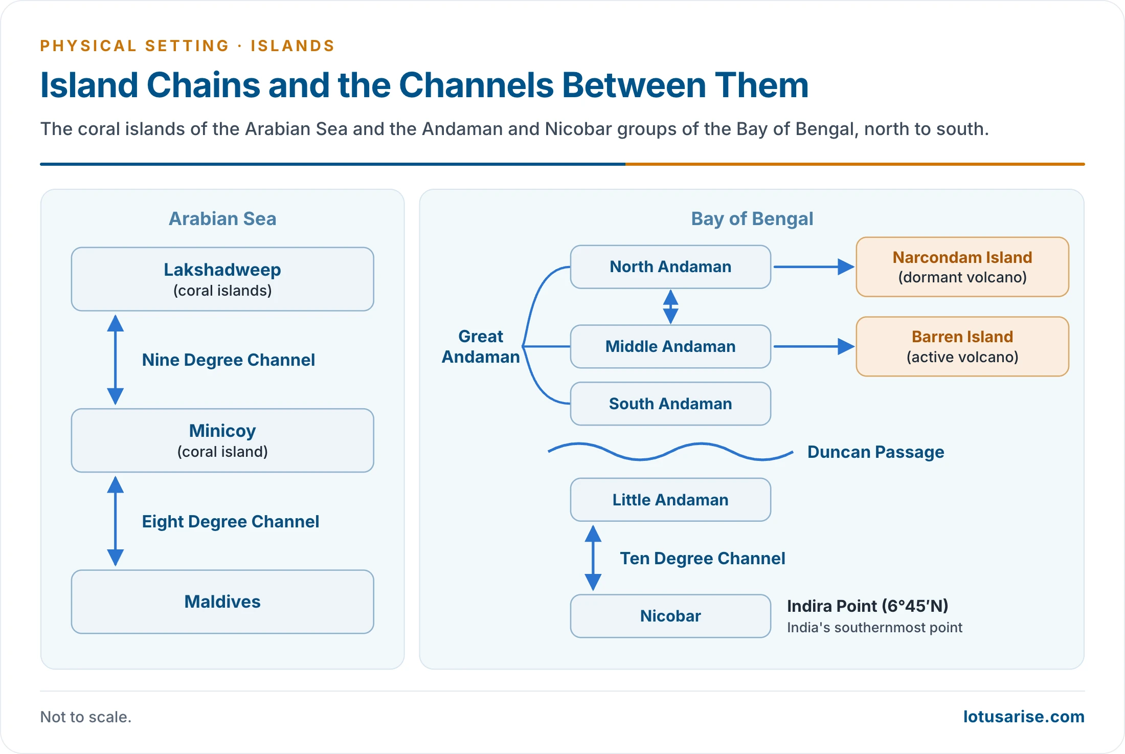
Andaman and Nicobar Islands
Extent and Divisions
- Situated in the Bay of Bengal, they run as a narrow arcuate chain, convex to the west, north to south.
- They extend from 6°45′N to 13°45′N and from 92°10′E to 94°15′E. Seven degrees of latitude come to about 780 km. Older accounts give a length of about 590 km and a greatest width of 58 km.
- Number: older counts give about 265 big and small islands (203 Andaman + 62 Nicobar). The current official count is 836 islands, islets and rocks, of which 31 are permanently inhabited. A count of 572 is also found.
- Area: about 8,249 sq km: Andamans 6,408 and Nicobars 1,841. Older figures are 6,596 and 1,653.
| Group | Main members | Notes |
|---|---|---|
| Great Andaman | North, Middle and South Andaman | North is 80 km by 20 km; Middle is 70 km by 30 km; South has parallel ranges and valleys |
| Little Andaman | Single large island | Across the Duncan Passage |
| Nicobar | Car Nicobar, Nancowry group, Little and Great Nicobar | Older count: 7 big and 12 small islands, over 262 km |
- Channels:
- Coco Strait (Coco Channel): between North Andaman and the Coco Islands of Myanmar.
- Duncan Passage: about 50 km wide, between South Andaman and Little Andaman.
- Ten Degree Channel: about 150 km wide, between the Andaman and Nicobar groups.
- Grand Channel (Great Channel): between Great Nicobar and Sumatra in Indonesia.
- Sri Vijaya Puram, known as Port Blair until September 2024, is the capital and main port. It lies in South Andaman.
- Among the Nicobars:
- Great Nicobar is the largest (about 862 sq km) and the southernmost. It lies only about 147 km from Sumatra, and Indira Point (6°45′N) on it is India’s southernmost point.
- Car Nicobar is the northernmost, about 229 km from Sri Vijaya Puram.
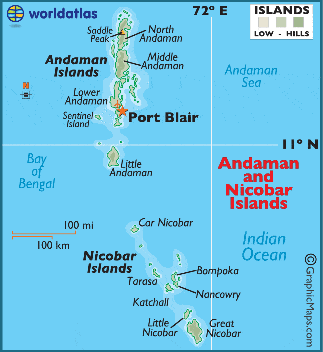
- This map should read 92°E for “72°E” and South Andaman for “Lower Andaman”. Port Blair is now Sri Vijaya Puram.
Origin and Rocks
- They were formed by the collision of the Indian Plate with the Burma microplate, a part of the Eurasian Plate. This is the same convergence that raised the Himalaya, here expressed as a subduction arc.
- They are a southward extension of the Arakan Yoma range of Myanmar, which itself continues the Purvanchal Hills. The chain runs on to Sumatra.
- They are the emerged tops of a submerged ridge. Lower ground around them sank in geological time, leaving the crests as islands.
- The usual rock is Tertiary sandstone, shale and limestone, laid over ultrabasic and basic igneous bodies, much as in the Himalaya.
- Barren and Narcondam, to the north-east of Sri Vijaya Puram, are volcanic islands. There is no active volcano on mainland India.
- Barren Island is India’s only volcano in regular eruption. It erupted mildly on 13 and 20 September 2025, and lava flows on its north flank ran from mid-November to December 2025.
- Narcondam (710 m), India’s easternmost island, is formed of andesite and is generally treated as dormant.
Relief, Climate and Life
- Relief: most of the islands are mountainous, many are covered with thick forest, and some are fringed with coral reefs. The top of the chain is Saddle Peak in North Andaman, at 732 m (older figure 737 m).
- Climate: a tropical marine climate shaped by the seasonal monsoon winds, with rain from both monsoons.
- Vegetation: dense tropical rain forest, with mangrove forest along the coasts. They are also called the Emerald Islands.
- Fauna:
- The Giant Robber Crab, the largest and one of the rarest crabs, can climb coconut trees and break the hard shell of the fruit.
- The dugong (sea cow), a herbivorous marine mammal of Indo-Pacific coasts, is the state animal.
- Economy: among Nicobarese communities coconut is the traditional staple. Fisheries and piggery are also followed.
- People: many islands are uninhabited, and the inhabited ones are sparsely peopled.
- The Sentinelese of the Andamans are often described as the last known Palaeolithic people. They remain one of the few human groups untouched by modern civilisation.
- Hazard: the whole region lies in seismic zone V. The 26 December 2004 earthquake and tsunami raised some coasts and sank others.
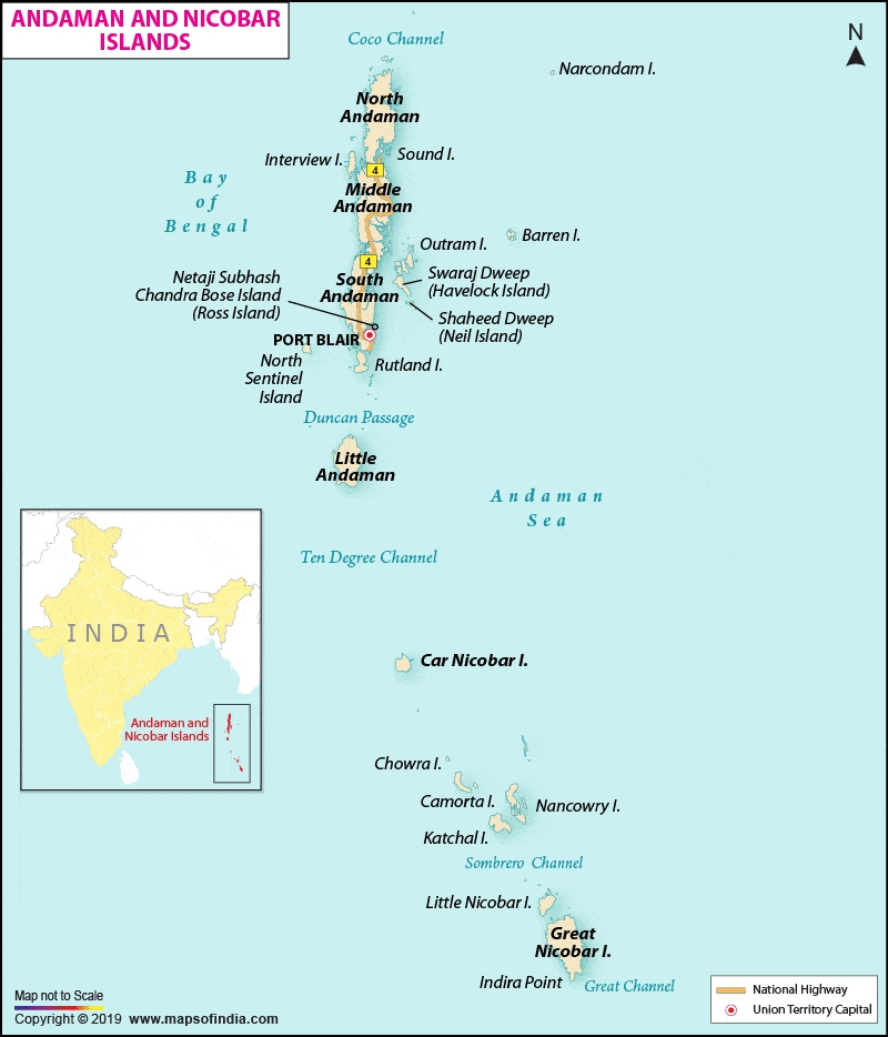
- Port Blair on this map is now Sri Vijaya Puram.
Ritchie’s Archipelago and Renamed Places
- Ritchie’s Archipelago is a cluster of smaller islands about 20 km east of Great Andaman. Neil and Havelock belong to it.
- Ross Island lies in the South Andaman region, 3 km east of the capital.
| Old name | New name | Date |
|---|---|---|
| Ross Island | Netaji Subhas Chandra Bose Dweep | 30 December 2018 |
| Neil Island | Shaheed Dweep | 30 December 2018 |
| Havelock Island | Swaraj Dweep | 30 December 2018 |
| Port Blair | Sri Vijaya Puram | Announced 13 September 2024 |
- On 23 January 2023, 21 unnamed islands were named after recipients of the Param Vir Chakra.
Great Nicobar Project
- Plan (Government of India, 1 May 2026):
- A 14.2 million TEU transshipment terminal at Galathea Bay, about 40 nautical miles from the East–West shipping route, with natural depth of over 20 m.
- A greenfield international airport, a 450 MVA gas and solar power plant, and a 16,610-hectare township.
- 166.10 sq km in three phases from 2025 to 2047, of which 130.75 sq km is forest land.
- Government’s position: it reduces dependence on Colombo, Singapore and Klang, and adds to national security. Clearance carries 42 conditions. The forest diverted is 1.82% of the islands’ forest cover, and no displacement is proposed for the Shompen (about 237) and Nicobarese (about 1,094).
- Critics’ position: environmental groups, some tribal bodies and opposition leaders point to tree felling, coral, leatherback turtle nesting and tribal rights. They also question the process of forest rights consent.
- Legal position:
- The National Green Tribunal found no good ground to interfere in February 2026, while setting conditions.
- The Calcutta High Court rejected the Centre’s objection to a petition in May 2026. The Supreme Court declined to disturb that order on 5 October 2026. Final hearing is listed for 25–26 November 2026.
- Recent steps: the Centre approved up to ₹13,000 crore for a dual-use airport on 8 June 2026, and the Ports Minister spoke of a 2028 groundbreaking for the port that month.
Lakshadweep Islands
Extent and Administration
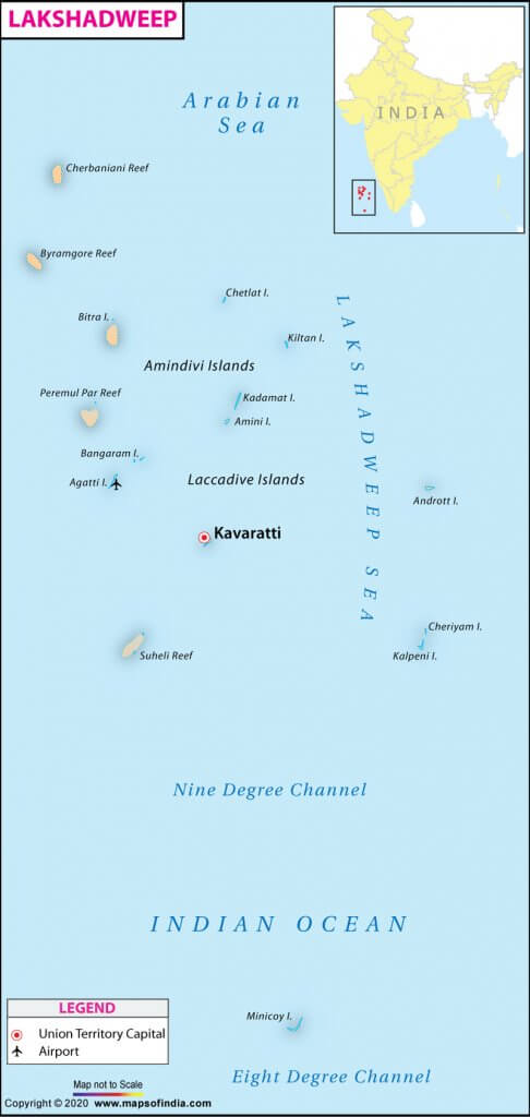
- A group of 36 islands with an area of 32 sq km in the Arabian Sea, extending between about 8°N and 12°N latitude.
- Main islands: Kavaratti, Agatti, Minicoy and Amini.
- Name: earlier known as the Laccadive, Minicoy and Amindivi Islands. Lakshadweep was adopted on 1 November 1973, and in Malayalam and Sanskrit it means “a hundred thousand islands”.
- Status: a Union Territory, and India’s smallest, administered by the President through an Administrator. It is a single district.
- Kavaratti is the administrative capital and principal town.
- Structure: 12 atolls, 3 reefs, 5 submerged banks and 10 inhabited islands. Very narrow straits part neighbouring islets.
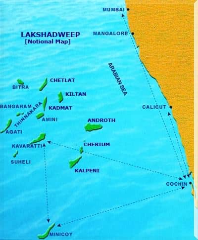
- Distance: commonly given as 220–440 km from Kochi. An older figure is 280–480 km off the coast of Keralam (Kerala), and Bitra lies about 483 km from Kochi.
- Sub-groups: islands north of 11°N form the Amindivi group, those to the south the Cannanore (Laccadive) group, and Minicoy stands alone in the far south.
Origin and Physical Features
- These are coral islands, associated with Réunion Hotspot volcanism. The hotspot built the ridge beneath them, and the whole group is made up of coral deposits.
- The archipelago probably marks the site of a submerged land.
- Storm beaches of unconsolidated pebbles, shingle, cobbles and boulders occur here.
- Relief: most islands do not rise more than five metres above sea level, which leaves them extremely vulnerable to sea-level change. The land is flat, and hills, streams and valleys are absent.
- Shallow lagoons lie on the western side, with steeper slopes on the east.
- Forests are absent.
- Fishing is the main livelihood, with coconut as the main crop.
- Pitti Island is a breeding place for sea turtles and pelagic birds such as the brown noddy, lesser crested tern and greater crested tern. It has been declared a bird sanctuary.
Size and Channels
- Largest island: Andrott, about 4.90 sq km. Minicoy (Maliku) follows at about 4.80 sq km. It lies south of the Nine Degree Channel and is often called the largest, with a figure of 4.53 sq km in older accounts.
- Smallest inhabited island: Bitra, about 0.105 sq km (older 0.12 sq km).
- Eight Degree Channel: separates Minicoy from the Maldives.
- Nine Degree Channel: separates Minicoy from the main Lakshadweep archipelago.
Present Developments
- Bitra: a Revenue Department notice of 11 July 2025 proposed to acquire the entire island for defence and strategic agencies, citing its location. Residents and the local Member of Parliament opposed it.
- Naval bases already stand at INS Dweeprakshak (Kavaratti) and INS Jatayu (Minicoy).
- Land use: the Lakshadweep Town and Country Planning and Development Regulation, 2026 was issued on 28 July 2026. The administration presents it as planned development. Critics say it widens land acquisition over a tribal population.
- Projects: the Prime Minister launched projects of about ₹1,150 crore in January 2024, with tourism on the islands as a stated aim.
Other Islands of India
New Moore Island
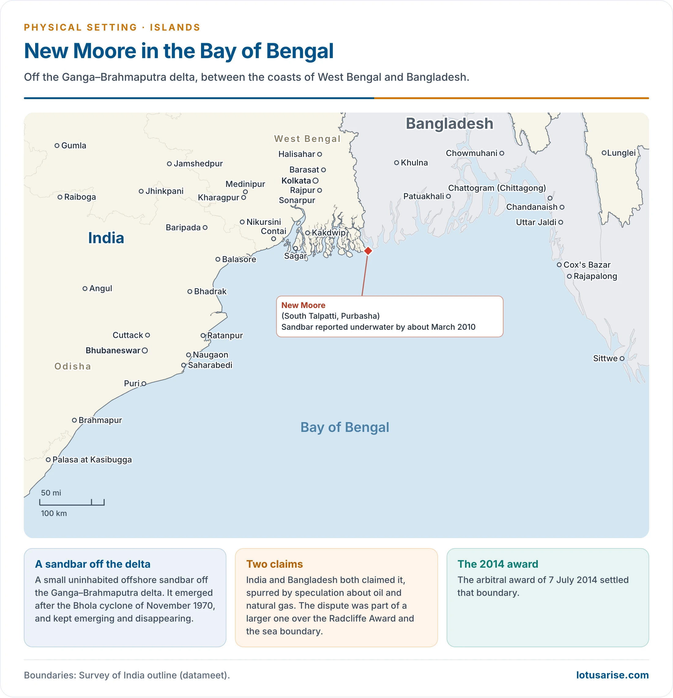
- New Moore, also called South Talpatti or Purbasha, was a small uninhabited offshore sandbar, a marine landform, in the Bay of Bengal off the Ganga–Brahmaputra delta.
- It emerged after the Bhola cyclone of November 1970. It kept emerging and disappearing, and was reported underwater by about March 2010.
- Although it had no permanent settlement, India and Bangladesh both claimed it, spurred by speculation about oil and natural gas.
- The dispute was part of a larger one over the Radcliffe Award and the sea boundary. The arbitral award of 7 July 2014 settled that boundary.
Diu Island
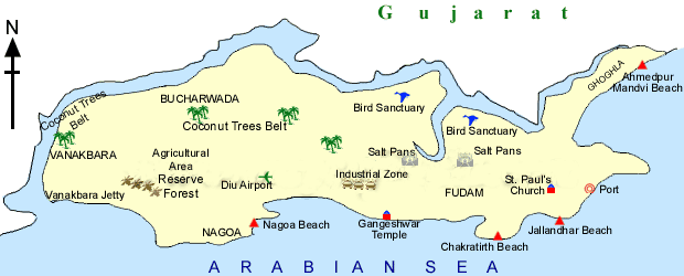
- It lies off the south coast of Kathiawar, near the Gulf of Cambay (Khambhat). A tidal creek separates it from Gujarat. It borders present Gir Somnath district, part of the older Junagarh district.
- It is about 38 sq km, and belongs to the Union Territory of Dadra and Nagar Haveli and Daman and Diu, merged in 2020.
- Coast: limestone cliffs, rocky coves and sandy beaches. Nagoa is the best known, followed by Ghoghla.
- It is famous for the historic Diu Fort, a massive Portuguese work that dominates the skyline.
Majuli Island
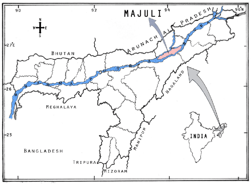
- Majuli is a large river island in the Brahmaputra in Assam, between the main river to the south and an anabranch to the north, with the Subansiri to the west.
- Origin: it was formed by course changes of the Brahmaputra and its tributaries, mainly the Lohit.
- It was once land between the Brahmaputra (north) and the Burhidihing (south). Medieval earthquakes changed the river’s course and made the island.
- Status: the world’s largest river island by Guinness World Records, and India’s first island district (2016).
- Shrinking: erosion cut it from 733.79 sq km in 1914 to 502.21 sq km in 2004, with 524.29 sq km in 2016 on current official work.
- Culture: the abode of Assamese neo-Vaishnavite culture.
- Biodiversity: a wetland that hosts rare and migratory birds in winter, including the Greater Adjutant Stork, Pelican, Siberian Crane and Whistling Teal.
Islands Off Mumbai
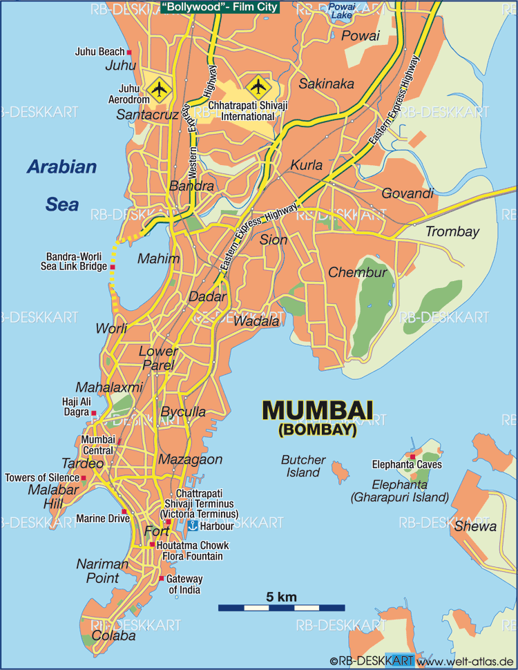
- Butcher Island (Jawahar Dweep): off Mumbai, about 8.25 km (5.13 mi) from the Gateway of India.
- Its oil terminal lets port authorities offload crude from tankers. The oil is stored on the island and then piped to Wadala for the Mumbai refineries.
- This keeps the city relatively safe from a mishap. The island is restricted, mostly under dense vegetation, with a hillock at its centre.
- Elephanta (Gharapuri) Island: in Mumbai Harbour, home to the rock-cut Elephanta Caves, a UNESCO World Heritage Site since 1987.
- Oyster Rock: a fortified islet in the harbour, owned by the Indian Navy.
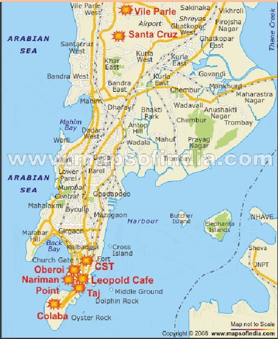
- The red markers on this map show the sites of the November 2008 attacks in Mumbai and have nothing to do with the islands.
Sriharikota
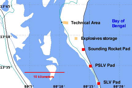
- A barrier island off the coast of Andhra Pradesh, now in Tirupati district. It is a long sand spit that separates Pulicat Lake from the Bay of Bengal. Pulicat town stands at the southern end of the lake.
- It houses the Satish Dhawan Space Centre (SHAR), from which the Indian Space Research Organisation launches the Polar and Geosynchronous Satellite Launch Vehicles.
- It was long India’s only satellite launch centre. A second spaceport at Kulasekarapattinam in Tamil Nadu is targeted for commissioning in 2026–27.
Pamban Island
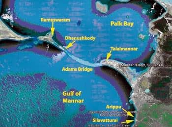
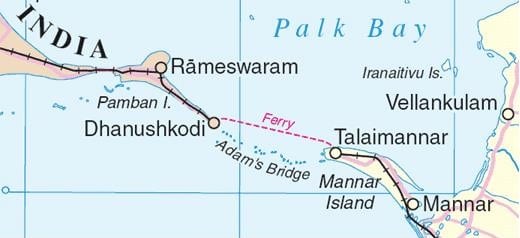
- It lies between India and Sri Lanka, in the Gulf of Mannar side of Ramanathapuram district, Tamil Nadu. It is also known as Rameswaram Island, and most of it is under white sand.
- Pamban Island, the shoals of Adam’s Bridge and Mannar Island of Sri Lanka together separate Palk Bay and the Palk Strait in the north-east from the Gulf of Mannar in the south-west.
- It stretches for about 30 km from Pamban town in the west to the remains of Dhanushkodi in the south-east.
- The New Pamban Bridge, about 2.08 km long, was opened on 6 April 2025 as India’s first vertical-lift railway sea bridge.
Other Named Islands
- Abdul Kalam Island (formerly Wheeler Island): off the Odisha coast, about 150 km east of Bhubaneswar. It is India’s main missile testing site. It was named after an English commandant, Lieutenant Hugh Wheeler, and was renamed on 4 September 2015.
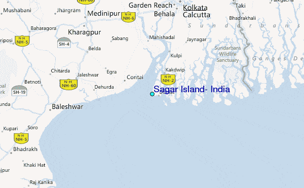
- Sagar Island: a large island in the Ganga delta in the Bay of Bengal, about 100 km south of Kolkata and West Bengal’s largest. It is a place of Hindu pilgrimage at Makar Sankranti.
- Halliday Island: in the Sundarbans of West Bengal, in the River Matla, designated a wildlife sanctuary.
- Phumdis (floating islands): masses of vegetation and soil on Loktak Lake, Manipur. Keibul Lamjao National Park stands on them, the home of Eld’s deer (Sangai).
- Munroe Island: an inland group of eight small islets, about 13.4 sq km, where Ashtamudi Lake meets the Kallada River in Kollam district, Keralam.
- Nayachar: in the Hugli estuary of West Bengal.
Offshore Islands
- Numerous islands lie in the Ganga delta and the Gulf of Mannar. Others, by coast:
| Coast | Islands |
|---|---|
| Kathiawar | Piram, Bhaisala, Diu |
| Kachchh | Vaida, Nora, Pirotan (Pirtan), Karumbhar (Karunbhar) |
| Narmada–Tapi mouths | Khadiabet (Khadiahet), Aliabet |
| Near Mumbai | Butcher, Elephanta, Karanja, Cross |
| Mangalore coast | Bhatkal, Pigeon (Pegioncock), St Mary |
| Keralam and Gulf of Mannar | Vypin near Kochi; Pamban, Crocodile, Adunda |
| East coast | Sriharikota (Pulicat Lake), Parikud or Pairkud (Chilika Lake), Short and Wheeler (Mahanadi–Brahmani mouth) |
| Ganga delta | New Moore, Ganga-Sagar, Sagar |
- Many of these are uninhabited and are administered by the adjacent States.
- A full place list is kept in Important Islands of India.
Kachchatheevu (Katchatheevu) Island
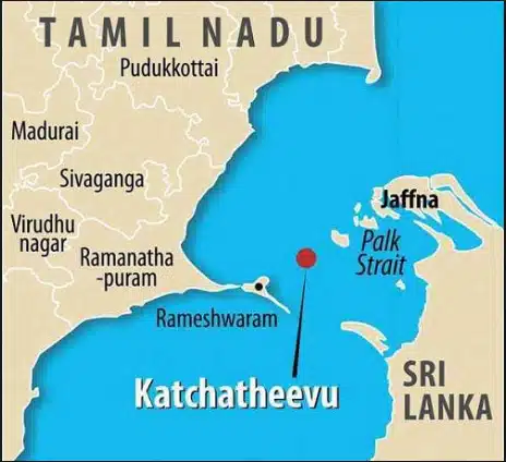
- An uninhabited offshore island in the Palk Strait, of about 285 acres (older 1.92 sq km), about 24 km from Rameswaram.
- It was held by the Raja of Ramnad (present Ramanathapuram, Tamil Nadu). Fishermen use it to dry their nets, and it holds St Anthony’s church.
- Claims: in British times, both the Madras side and Ceylon dealt with it, and Ceylon pressed a claim in the early 20th century.
- 1974: an India–Sri Lanka agreement fixed the sea boundary and placed it on the Sri Lankan side.
- 1976: a further agreement ended fishing by either side in the other’s waters, the root of today’s fishermen issue.
- Positions now: the Tamil Nadu Assembly sought its retrieval by resolution in April 2025. On 6 October 2026, in petitions pending since 2008, the Attorney General told the Supreme Court the Centre does not wish to reopen the treaties. The matter is listed for February 2027.
Previous Year Questions
2026Critically examine the strategic, economic and ecological impacts of the proposed ‘Great Nicobar Project’.2026Map item: Bitra Island2025Map item: Sri Vijayapuram2023Examine the geostrategic significance of Indian islands.2023Map item: Ross Island2022Map item: Maliku Atoll2021Map item: Pamban Island2019Map item: Barren Island2017Map item: Nayachar Island2017Map item: Havelock Island2015Map item: Narcondam
Amazing info…thanx so much
I want to buy notes but first I would like to see some part of the notes if you can then please send me.thanku
Please contact on Telegram/Whatsapp.
Thank you so much sir ❤️
Amazing notes. i really appreciate this page.