

- Trewartha’s classification is a modified Köppen scheme that redraws the middle latitudes by the length of the warm season and explains each type through the air masses, pressure systems and winds that control it.
- It was devised by the American geographer Glenn Thomas Trewartha (1896–1984) of the University of Wisconsin, refined through editions of An Introduction to Climate (1954, 1968), published as a full scheme in 1966 and revised with Lyle H. Horn in 1980.
- It stands midway between empirical and genetic schemes: boundaries come from observed data, but each type is described by its causes.
Basis and Aims
- Reaction to complexity: the Köppen and Thornthwaite schemes produce too many statistical types to remember or map.
- Trewartha kept fewer than 15 principal types, open to second- and third-order subdivision when needed.
- Elements: temperature and precipitation, plus the effect of land and water (marine versus continental types).
- Key innovation: the number of months with a mean of 10°C or more, a measure of the growing season, replaces Köppen’s coldest-month limits in the middle latitudes.
- This splits Köppen’s overly broad C group into subtropical (C) and temperate (D), and its D group into temperate and boreal (E).
- Purpose: a framework for land use, settlement and regional description, so names (tropical wet, temperate oceanic) are used alongside letters.
The Climatic Groups
| Group | Thermal criterion | Character |
|---|---|---|
| A Tropical humid | All months ≥ 18°C | No winter, no frost |
| C Subtropical | 8–12 months ≥ 10°C | Mild winter, long summer |
| D Temperate | 4–7 months ≥ 10°C | Real winter and summer |
| E Boreal | 1–3 months ≥ 10°C | Short cool summer, long severe winter |
| F Polar | No month ≥ 10°C | No true summer |
| B Dry | Rain below a threshold | Evaporation exceeds rain |
| H Highland | Altitude-controlled | Undifferentiated mountains |
- Five groups are thermal; B is defined by moisture; H stands apart.
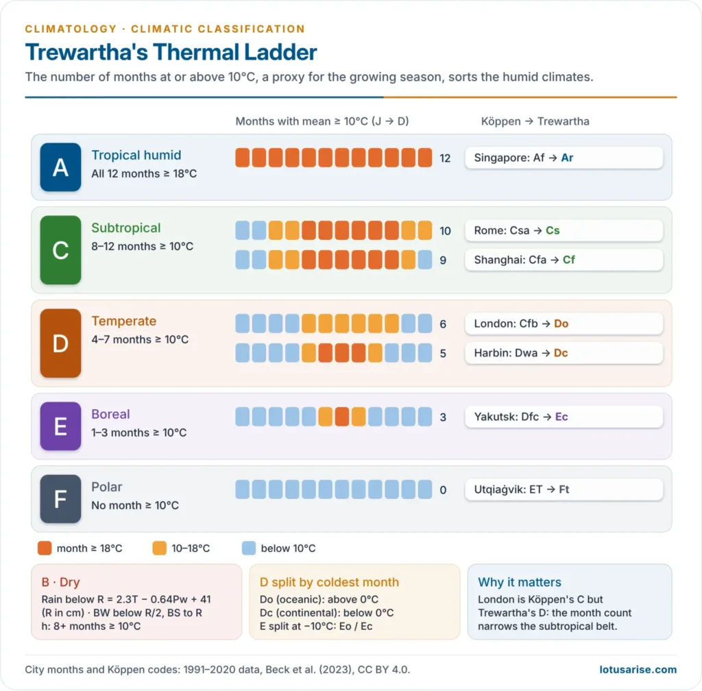
A: Tropical Humid
- Ar, tropical wet: no more than two dry months; 5°–10° either side of the equator, wider on windward eastern margins.
- Ruled by the ITCZ and equatorial westerlies; constant low pressure; rainforest.
- Aw, tropical wet-and-dry (savanna): dry low-sun season of more than two months.
- Subtropical highs and dry trades in winter; ITCZ in the high-sun season.
- As (high-sun dry) is rare; Am (monsoon) was added later.
C: Subtropical
- Cs, dry-summer (Mediterranean): driest summer month below 3 cm; annual rain under about 89 cm; on western sides at 30°–40°.
- Summer under the stable eastern end of an oceanic subtropical high; winter rain from westerly cyclones.
- Cf, humid subtropical: rain in all seasons, summer maximum; on eastern sides.
- Summer under unstable air on the western end of a subtropical high; winter temperate cyclones.
- Cw, dry winter: monsoon-influenced subtropics such as north India and south China.
D: Temperate
- Do, temperate oceanic: coldest month above 0°C; windward west coasts with rain in all seasons, as in north-west Europe.
- Dc, temperate continental: coldest month below 0°C; continental interiors of the Northern Hemisphere only.
- Large annual range, snow cover, cold waves, heat waves and blizzards; summer rain maximum.
E: Boreal
- Super-continental: the lowest annual mean temperatures of any inhabited climate and very large annual ranges.
- Meagre precipitation, mostly in summer; coniferous forest (taiga); sparse population.
- Later split into Eo (oceanic) and Ec (continental) at a coldest month of −10°C.
F: Polar
- Ft, tundra: warmest month 0°–10°C; permafrost, treeless mosses and lichens; on land only in the Northern Hemisphere and the tip of the Antarctic Peninsula.
- Fi, ice cap: all months below 0°C; Greenland and Antarctica; surface inversions and dry, powdery snow.
B: Dry
- Boundary: R = 2.3T − 0.64Pw + 41, with R in cm, T in °C and Pw the percentage of rain falling in winter.
- Below R/2 is BW (arid); between R/2 and R is BS (semi-arid).
- h/k split: h where 8 or more months are ≥ 10°C, the same line that separates C from D.
- BWh and BSh occupy the subsiding, diverging air of subtropical highs and dry trades; BWk and BSk lie in continental interiors and rain shadows, treated as poleward extensions of hot deserts.
H: Highland
- No single highland climate: every large range holds many local climates set by altitude, slope and exposure.
- Windward slopes are wet from forced ascent; leeward slopes are dry and warm from descent.
Trewartha and Köppen Compared
| Point | Köppen | Trewartha |
|---|---|---|
| Middle-latitude basis | Coldest-month limits (18°C, −3°C) | Months ≥ 10°C |
| Groups | A, B, C, D, E (+H) | A, C, D, E, F, B, H |
| Approach | Purely empirical | Empirical boundaries, genetic description |
| Dry boundary | Temperature and rain season | Temperature and winter-rain share |
| Types | About 30 | Under 15 principal |
| Fit in mid-latitudes | Too broad | Closer to vegetation zones |
India under Trewartha
| Type | Region | Features |
|---|---|---|
| Am Tropical monsoon | Western Ghats coast, western Nagaland, Tripura | Over 200 cm rain, short dry season |
| Aw Tropical savanna | Most of the Peninsula outside the rain shadow | Long winter dry season |
| BS Tropical steppe | Rain shadow: interior Karnataka, central Maharashtra, western Telangana and Andhra, interior Tamil Nadu | Under 75 cm |
| BSh Subtropical steppe | Punjab to Kachchh | 50–75 cm, hot summers |
| BWh Subtropical desert | Western Rajasthan, Kachchh | Under 25 cm |
| Caw Subtropical humid, dry winter | Punjab foothills, Ganga plain, Assam, Arunachal | Hot summer, cool dry winter |
| H Mountain | Kashmir, Himalaya | Varies with altitude and slope |
- The scheme fits Indian vegetation and agricultural regions well, as the dry-winter Caw matches the rice-wheat plains.
Evaluation
Merits
- Simple, few types, easily mapped and memorised.
- Better middle latitudes: the 10°C month count tracks the growing season and vegetation.
- Genetic explanation of each type through air masses and circulation.
- Built for geographers: types match land use and settlement.
Limitations
- Boundaries remain empirical; genetic content is descriptive, not used to draw lines.
- Little mathematical precision; the dry formula, like Köppen’s, only estimates evaporation.
- Highlands left undifferentiated.
- Based on 30-year means, so the map shifts as climate changes.
Current View
- Michal Belda and colleagues (2014) applied the Köppen–Trewartha scheme to global gridded data for 1961–1990 and found observable 20th-century changes, especially in semi-arid, savanna and tundra types.
- An optional universal thermal scale (letters from i, severely hot, to e, excessively cold) now adds warmest- and coldest-month detail.





Thanks