

- India lies wholly in the Northern Hemisphere, and in the Eastern Hemisphere, in the south-central part of Asia. The mainland spans 8°4′N to 37°6′N and 68°7′E to 97°25′E.
- It is the seventh-largest country in the world. Mountains and sea mark it off from the rest of Asia and give it a distinct geographical identity.
- Its frontiers measure 15,106.7 km on land and 11,098.81 km along the coast, the coast on the measurement adopted in 2025. The older coastal figure of 7,516.6 km is still widely quoted.
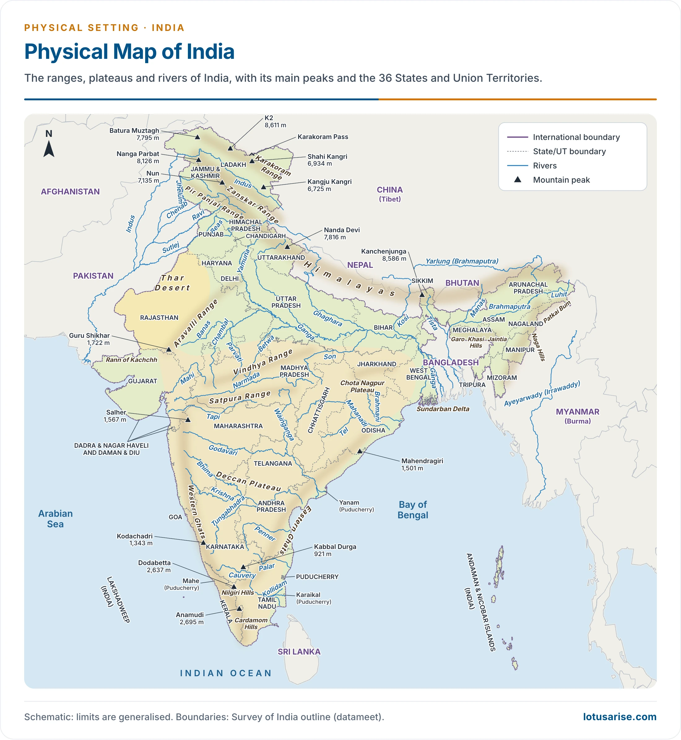
Location, Extent and Size
Location
- North: young fold mountains wall India on the north-west, north and north-east.
- South: the Indian Ocean. South of about 22°N the land narrows into a peninsula that parts the ocean: the Bay of Bengal lies on its east and the Arabian Sea on its west.
- Older accounts say the peninsula tapers “over 800 km”. From 22°N to Kanniyakumari the distance is in fact about 1,550 km by latitude, which agrees with the roughly 1,600 km usually given for the Peninsular tableland’s reach into the ocean.
- West: the marshy Rann of Kachchh, the Rajasthan desert and the Punjab plain.
- The Equator does not touch India. It crosses 13 countries: Ecuador, Colombia, Brazil, Sao Tome & Principe, Gabon, the Republic of the Congo, the Democratic Republic of the Congo, Uganda, Kenya, Somalia, Maldives, Indonesia and Kiribati.
- India’s nearest neighbour on that line is the Maldives.
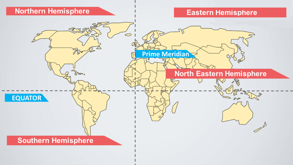
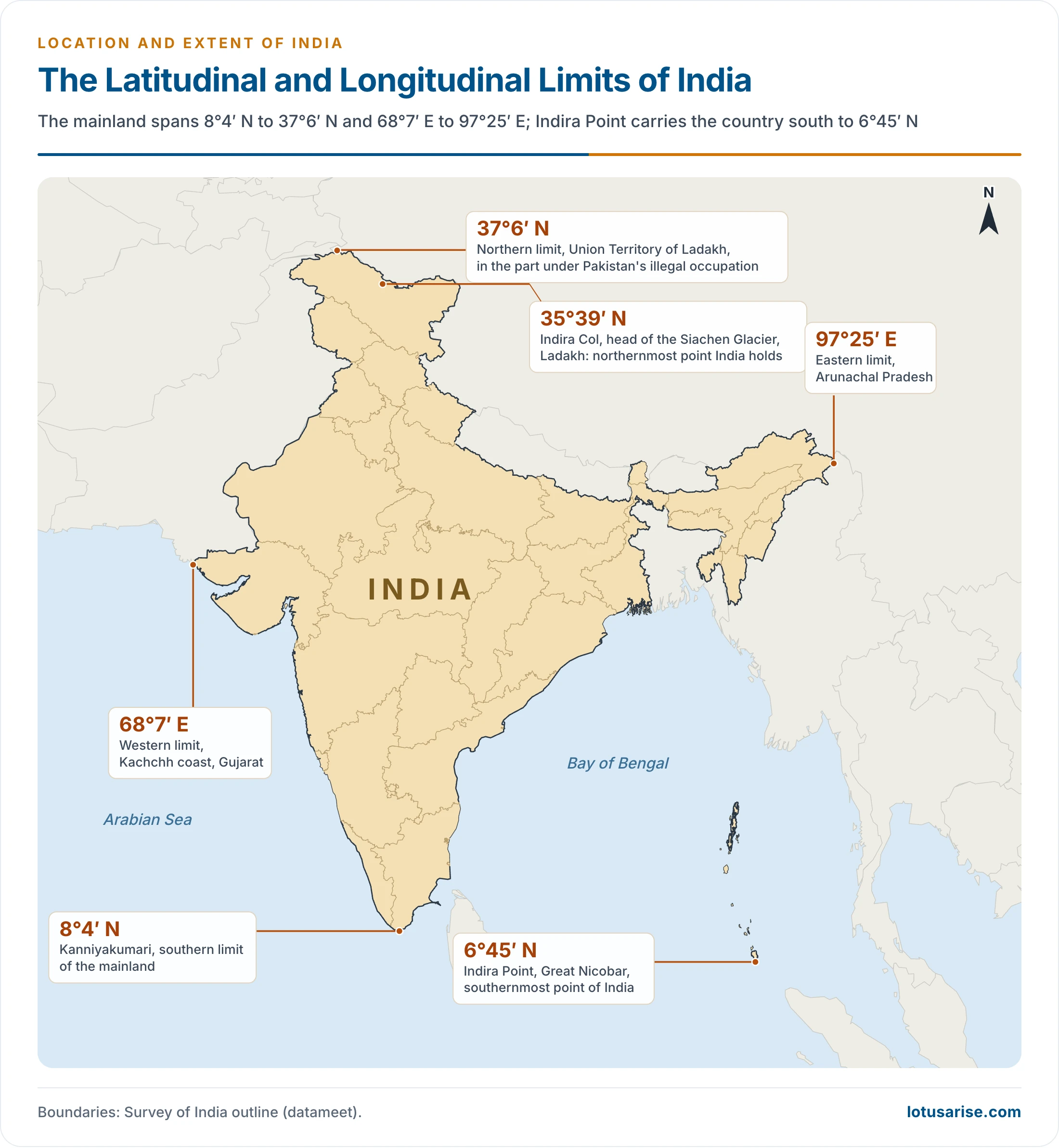
Latitudinal and Longitudinal Extent
| Measure | Limits |
|---|---|
| East-west extent of mainland India (including Pakistan-occupied Kashmir) | 68°7′E to 97°25′E |
| South-north extent of mainland India | 8°4′N to 37°6′N |
| Locational extent | 8°4′N to 37°6′N and 68°7′E to 97°25′E |
- Both spans come to about 30°: 29°2′ of latitude and 29°18′ of longitude.
- The latitudinal span is about one-third of the arc from the Equator to the North Pole.
- The longitudinal span is about one-twelfth of the Equator’s circle.
- Yet the east-west distance is shorter than the north-south distance: 2,933 km from the Rann of Kachchh to Arunachal Pradesh against 3,214 km from Indira Col to Kanniyakumari.
- Reason: meridians converge towards the pole. A degree of longitude is about 110 km at 8°N but only about 89 km at 37°N, while a degree of latitude stays near 111 km.
- The width is often overlooked because we speak of “Kashmir to Kanniyakumari” and rarely of “Kachchh to Arunachal”. It nearly equals the combined spread of Spain, France, Germany, Belgium, the Netherlands and Poland.
Extreme Points
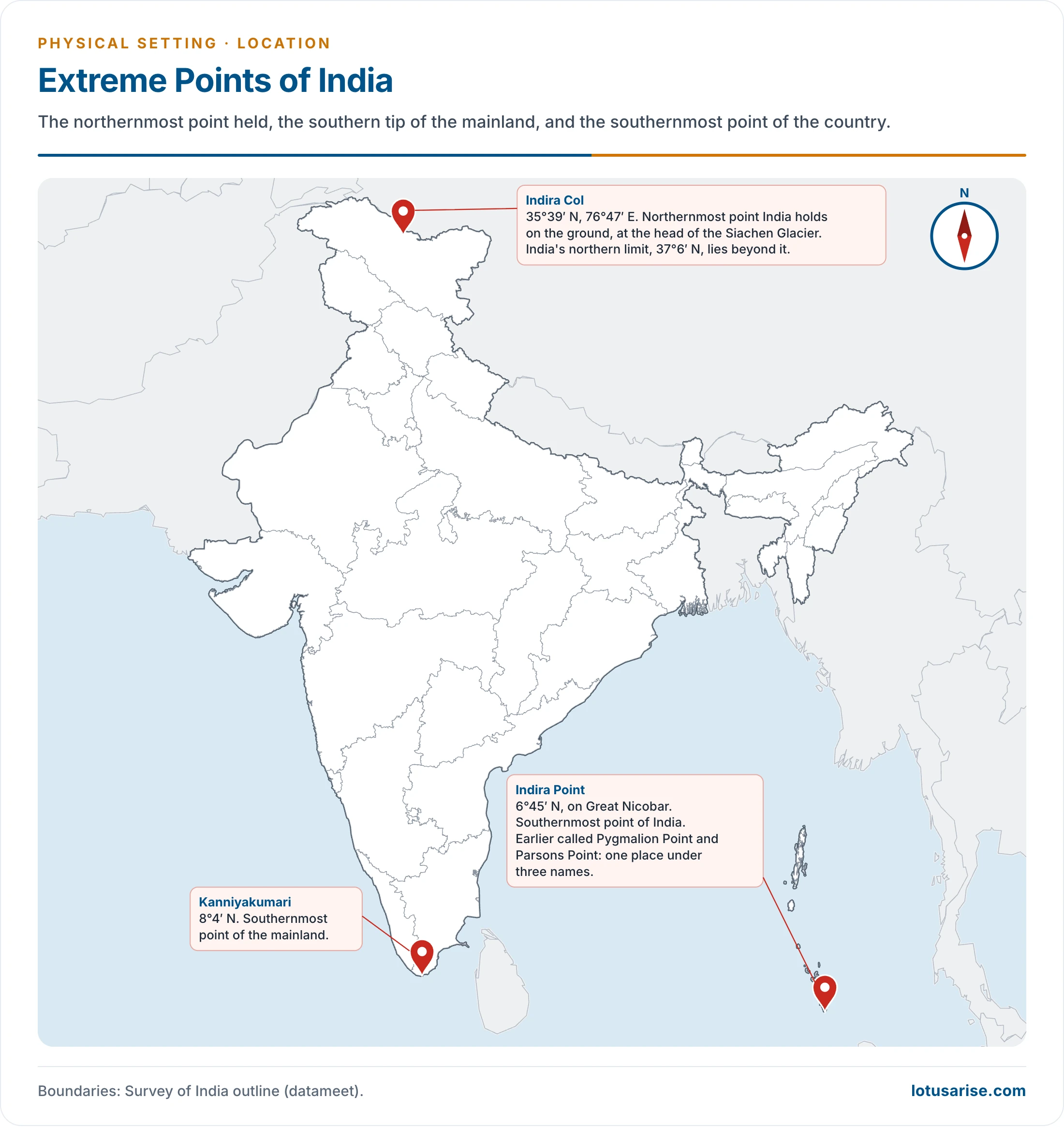
- Southernmost point: Indira Point, on Great Nicobar, at 6°45′N.
- It was earlier called Pygmalion Point and Parsons Point. It was renamed after Prime Minister Indira Gandhi, with the formal ceremony on 10 October 1985.
- The 2004 Indian Ocean earthquake lowered the tip by about 4.25 m, and part of its lighthouse now stands in the sea.
- Southernmost mainland point: Kanniyakumari, at 8°4′N.
- Northern limit: 37°6′N, in the part of the Union Territory of Ladakh under Pakistan’s illegal occupation.
- Indira Col (35°39′N, 76°47′E), at the head of the Siachen Glacier, is the northernmost point India holds on the ground. Older accounts place it “in Kashmir”; it now falls in Ladakh.
- East and west: Arunachal Pradesh at 97°25′E, and the Kachchh coast at 68°7′E.
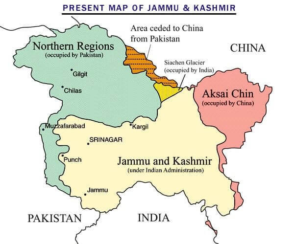
- This older map predates 2019 and uses foreign labels. Under India’s position all of it is Indian territory: the whole of the Union Territories of Jammu and Kashmir and Ladakh.
- “Northern Regions” is the part called Gilgit-Baltistan, under Pakistan’s illegal occupation.
- Siachen is not “occupied by India”: it is part of Ladakh and is held by India.

Size
- Area: 32,87,263 sq km, making India the seventh-largest country, after Russia, Canada, the USA, China, Brazil and Australia.
- This total includes the areas under the unlawful occupation of Pakistan and China.
- Share of the world: about 2.4 per cent. It is often written as a share of the world’s “total surface area”, but it is the share of its land outside Antarctica.
- Against the whole surface of the earth, land and sea together, India is only about 0.64 per cent.
- Relative size: about 13 times Great Britain, and about three-fourths of the Indian subcontinent. Many Indian States exceed whole countries in area.
- Effect of Partition: undivided India had 42,27,378 sq km. Partition removed 9,40,115 sq km: 7,96,095 to West Pakistan and 1,44,020 to East Pakistan, now Bangladesh.
The Tropic of Cancer
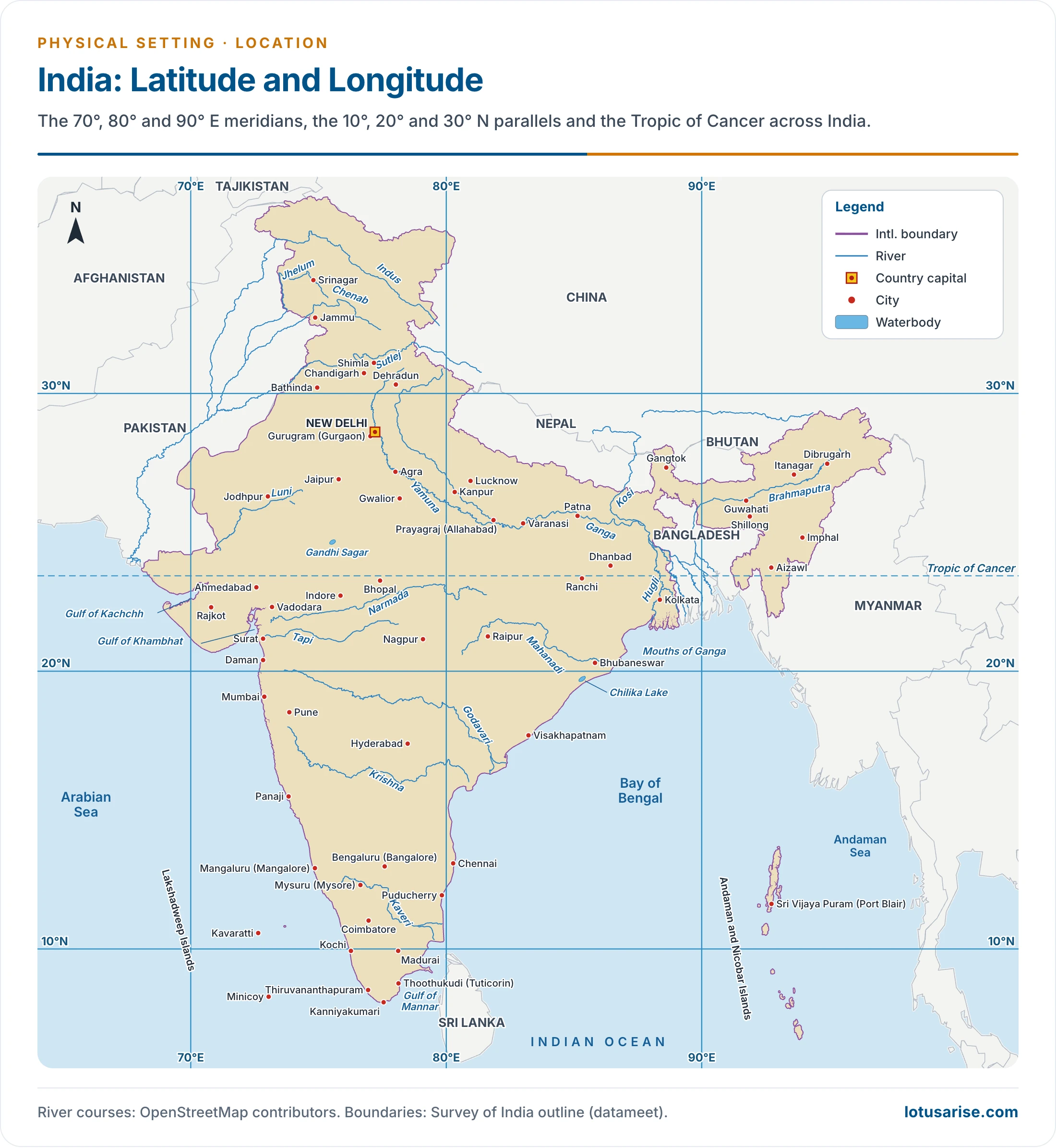
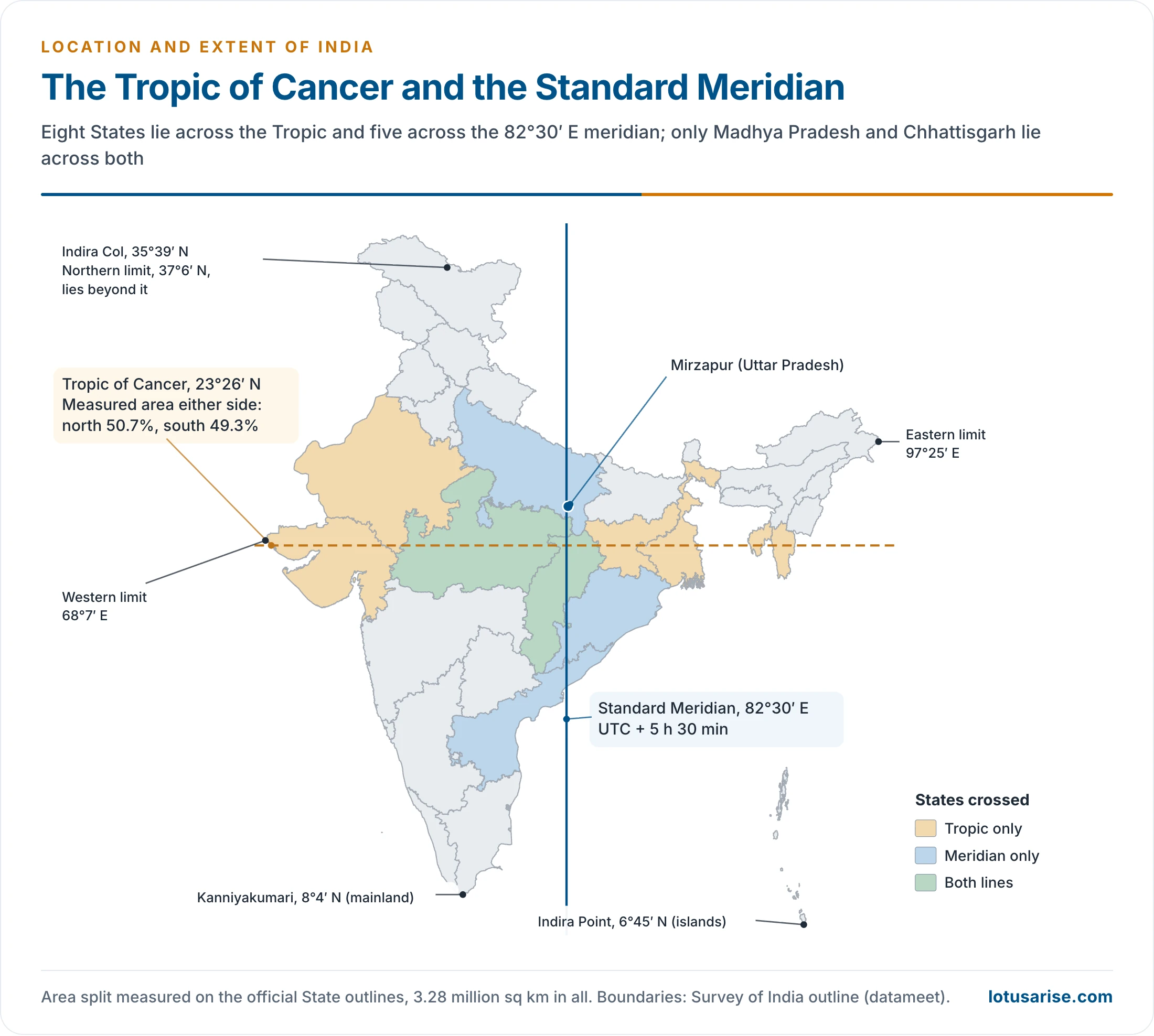
- The Tropic of Cancer (23°26′N) runs through the middle of the country and divides its latitudinal span into two nearly equal halves, about 15° on either side.
- It crosses eight States: Gujarat, Rajasthan, Madhya Pradesh, Chhattisgarh, Jharkhand, West Bengal, Tripura and Mizoram.
| State | Place usually named | Check against latitude |
|---|---|---|
| Gujarat | Jasdan | Wrong: Jasdan is at 22°2′N, about 155 km south. The line crosses the Kachchh–Mehsana–Sabarkantha belt |
| Rajasthan | Kalinjarh (Kalinjara) | Banswara district, in the far south of the State |
| Madhya Pradesh | Shajapur | Near the line |
| Chhattisgarh | Sonhat | Near the line, in the north of the State |
| Jharkhand | Lohardaga | Near the line |
| West Bengal | Krishnanagar | Near the line |
| Tripura | Udaipur | Near the line |
| Mizoram | Champhai | Near the line |
- Area either side: the classical statement is that the land north of the Tropic is nearly twice the land south of it. Because the north is so broad, this is widely repeated.
- Measured on the official State outlines, the two parts are almost equal: about 50.7 per cent north and 49.3 per cent south. The peninsula narrows southwards, but it is long, and the line runs well north of the Deccan.

Effects of Latitude on Day Length
- Latitude governs the length of day and night, and with it temperature, rainfall and vegetation.
- The gap between the longest and shortest day widens northwards.
- Classical figures: hardly 45 minutes in Keralam (Kerala), and about 4 hours at Leh.
- From solar geometry: about 1 hour at 8–10°N, and about 4.5 hours at Leh.
Standard Meridian and Time
- Principle: every place is measured east or west of the prime meridian (0°) at Greenwich, London, which is also the reference for Coordinated Universal Time (UTC). One hour corresponds to 15° of longitude, so 1° equals 4 minutes.
- Example: at 150°W, 150 ÷ 15 gives 10 hours behind UTC, or UTC−10.
- Local time gap: across India’s 29°18′ of longitude the gap is about two hours (117 minutes), from Gujarat to Arunachal Pradesh. The sun rises about two hours earlier in the east.
- Standard meridian: 82°30′E, through Mirzapur in Uttar Pradesh, is taken as the time for the whole country, so Indian Standard Time (IST) is UTC+5 h 30 min.
- The meridian passes through five States: Uttar Pradesh, Madhya Pradesh, Chhattisgarh, Odisha and Andhra Pradesh.
- CSIR-National Physical Laboratory is the custodian of IST.
- Before IST: there was no single official time until 1906. Bombay, Calcutta and Madras each kept their own.
- Two-zone debate: scientists at CSIR-National Physical Laboratory (2018) proposed IST-I (UTC+5:30) and IST-II (UTC+6:30), split at 89°52′E along the West Bengal–Assam border, to fit working hours in the North-East to daylight.
- A government High Level Committee advised against two zones for strategic reasons.
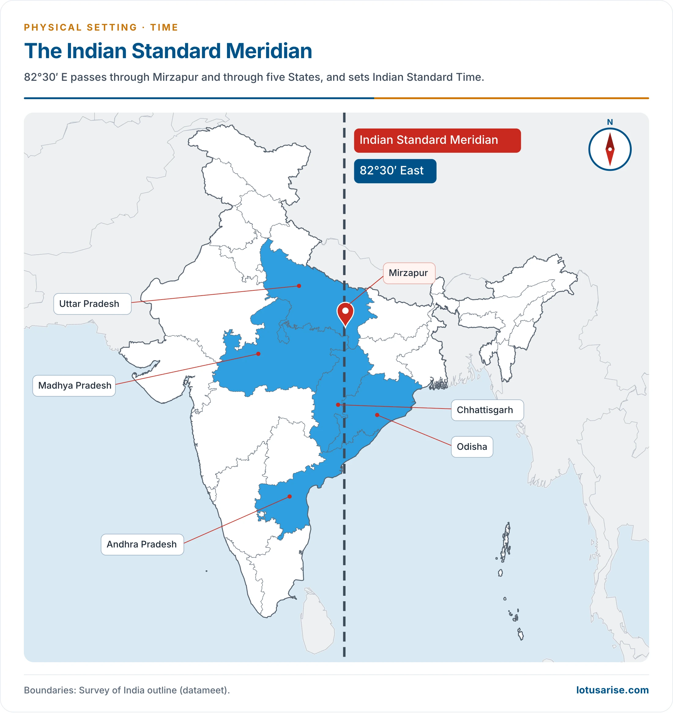
- The line on this map is the Indian Standard Meridian. The International Date Line is a different line, lying near 180°. Odisha was formerly called Orissa.
India: Tropical or Temperate?
- By the Tropic alone, India would be half tropical and half temperate; the classical wording gives the temperate part twice the tropical part (the measured split is above).
- Even so, India counts as a tropical country, on two separate grounds.
- Physical geography:
- The Himalaya separates the country from the rest of Asia, like a walled compartment.
- Tropical monsoons dominate the climate, and the mountains block temperate air masses.
- The whole area south of the Himalaya is essentially tropical in climate. Winter nights in North India may turn as cold as temperate lands, but clear skies and strong sun lift daytime temperatures to tropical levels.
- Cultural geography:
- Settlements, diseases, farming and primary activities are all tropical in nature.
- Outside the Himalaya, agriculture is almost everywhere tropical in type, and the culture differs from that of the temperate Western lands.
A Geographical Unit and a Subcontinent
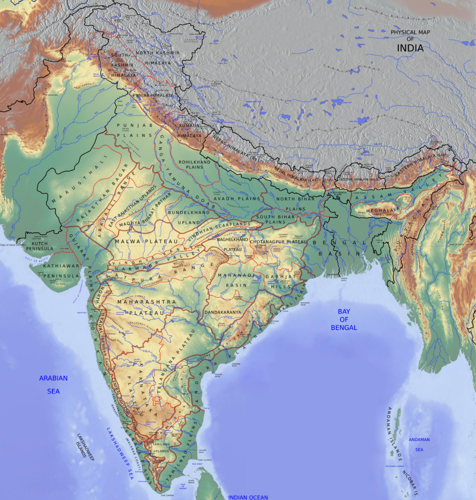
- Four great landforms make up the country: the Himalaya, the Indo-Gangetic plain with the Thar Desert on its west, the Peninsular plateau, and the coastal plains on both sides of it.
- Indian subcontinent: south of the mountains, India, Pakistan, Bangladesh, Nepal and Bhutan make up one clear realm. George Goudie Chisholm called it a region better demarcated by nature than any other in the world, and George Babcock Cressey backed the term.
- The objection: some Indian geographers call “subcontinent” a colonial legacy, since it is never applied to the larger and equally varied China or Russia. Many now prefer South Asia, which adds Sri Lanka and sometimes Afghanistan.
- Names of the country:
- India: from the Greek “Indoi”, the people near the Indos (Indus).
- Hindustan: Persian speakers turned Sindhu into Hindu, so this meant the land east of the Sindhu.
- Bharat or Bharat-Varsha: after the legendary King Bharata, or by another view the Bharata tribe.
- Aryavarta: the land of the Aryans.
- Only India and Bharat are official.
States and Union Territories
- At independence, India was a patchwork of nine British provinces and 562 princely states. It became a Union of States when the Constitution came into force on 26 January 1950, with four categories: Parts A, B, C and D.
- Today: 28 States and 8 Union Territories, reached through the changes in the table.
- Largest and smallest: The largest State is Rajasthan (3,42,239 sq km) and the smallest Goa (3,702 sq km). Rajasthan, Madhya Pradesh and Maharashtra each exceed 3 lakh sq km and together hold about 30 per cent of the area.
| Date | Change |
|---|---|
| 1 Oct 1953 | Andhra, the first linguistic State, carved from Madras |
| 1 Nov 1956 | States Reorganisation Act: 14 States, 6 Union Territories |
| 1 May 1960 | Bombay split into Gujarat and Maharashtra |
| 19 Dec 1961 | Goa, Daman and Diu freed from Portuguese rule |
| 1 Dec 1963 | Nagaland |
| 1 Nov 1966 | Punjab split; Haryana formed; hill areas go to Himachal Pradesh |
| 25 Jan 1971 | Himachal Pradesh a State |
| 21 Jan 1972 | Manipur, Tripura, Meghalaya |
| 16 May 1975 | Sikkim |
| 20 Feb 1987 | Arunachal Pradesh, Mizoram |
| 30 May 1987 | Goa a State |
| Nov 2000 | Chhattisgarh (1st), Uttarakhand (9th), Jharkhand (15th) |
| 2 Jun 2014 | Telangana |
| 31 Oct 2019 | Jammu and Kashmir reorganised into the Union Territories of Jammu and Kashmir and Ladakh |
| 26 Jan 2020 | Dadra and Nagar Haveli merged with Daman and Diu |
- Older lists of 29 States and 7 Union Territories predate the last two changes.
- The States Reorganisation Commission shaped the 1956 map, and demands for new States continue, among them Vidarbha, Harit Pradesh, Awadh Pradesh, Purvanchal, Bundelkhand, Gorkhaland, Bodoland, Garoland, Greater Cooch Behar and Kamtapur.
Land Frontiers
- Reference: Ministry of Home Affairs. India has 15,106.7 km of land border. The older round figure is about 15,200 km.
- Longest border: Bangladesh. Shortest: Afghanistan.
- Reach: the old count was 92 districts in 17 States. On the Ministry’s current list, the border touches 16 States and 2 Union Territories, Ladakh and Jammu and Kashmir.
- Frontline States: every State has an international border or a coast except Madhya Pradesh, Chhattisgarh, Jharkhand, Haryana and Telangana. Among Union Territories, Delhi (and Chandigarh) also has neither. All others count as frontline for border management.
| Neighbour | Length, Ministry of Home Affairs (km) | Older figure (km) | Indian States and UTs along it |
|---|---|---|---|
| Bangladesh | 4,096.7 | 4,096 | West Bengal, Assam, Meghalaya, Tripura, Mizoram |
| China | 3,488 | 3,917 | Ladakh, Himachal Pradesh, Uttarakhand, Sikkim, Arunachal Pradesh |
| Pakistan | 3,323 | 3,310 | Gujarat, Rajasthan, Punjab, Jammu and Kashmir, Ladakh |
| Nepal | 1,751 | 1,752 | Uttarakhand, Uttar Pradesh, Bihar, West Bengal, Sikkim |
| Myanmar | 1,643 | 1,458 | Arunachal Pradesh, Nagaland, Manipur, Mizoram |
| Bhutan | 699 | 587 | Sikkim, West Bengal, Assam, Arunachal Pradesh |
| Afghanistan | 106 | 80 | Ladakh |
| Total | 15,106.7 | 15,200 |
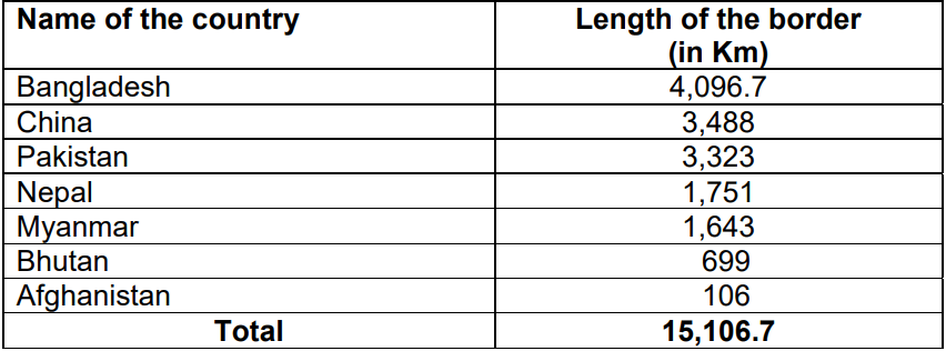
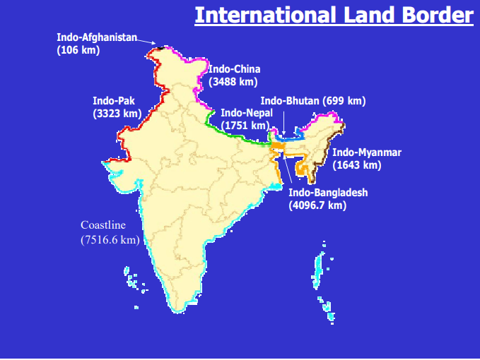
- Each line raises boundary issues of its own, and each can be read through the general laws of international boundaries and frontiers.
Border with China
- This is India’s second-longest border, after Bangladesh.
- Five units touch it. Older accounts list Jammu and Kashmir, Himachal Pradesh, Uttarakhand, Sikkim and Arunachal Pradesh; since 2019 the first is the Union Territory of Ladakh.
- Length: 3,488 km on the Ministry’s count. Older sector lengths add up to 3,917 km, and some maps, as below, show about 4,050 km. The boundary has never been agreed, so counts differ.
- Origin: it grew from Manchu, Chinese Republican and British policy. Rugged ground made demarcation hard, so it was drawn only loosely on maps between British India and independent Tibet.
- Key dates:
- 1954: the Panchsheel agreement. Its five principles are respect for territorial integrity and sovereignty, non-aggression, non-interference, equality and mutual benefit, and peaceful co-existence.
- 1954: India recognised Chinese sovereignty over Tibet, so Tibet’s buffer role ended.
- 1956: China’s road across Aksai Chin, linking Tibet and Xinjiang.
- October 1962: the war, launched in Ladakh and NEFA (now Arunachal Pradesh). It ended the belief that the Himalaya alone was a defence barrier. China withdrew in the east but kept most of Aksai Chin.
- It is divided into three sectors.
| Sector | Older length | Indian side | Chinese side | Status |
|---|---|---|---|---|
| Western | 2,152 km | Ladakh | Xinjiang, Tibet | Aksai Chin occupied by China |
| Middle | 625 km | Himachal Pradesh, Uttarakhand | Tibet | Least disputed |
| Eastern | 1,140 km | Arunachal Pradesh | Tibet | McMahon Line, rejected by China |
The Western Sector
- It separates the Union Territory of Ladakh (erstwhile Jammu and Kashmir) from Xinjiang (Sinkiang). It grew largely out of British policy towards Jammu and Kashmir, and was never precisely fixed on maps.
- Alignment claimed by India: along the Muztagh and Aghil ranges and across the Karakoram Pass to the Kunlun, then by the Lanak La and the watersheds separating the Indus system from the Tarim and Khotan systems.
- China’s claims: the Aksai Chin district, the Changmo valley, Pangong Tso and the Sponggar Tso area of north-east Ladakh, and a belt of about 5,000 sq km along all of eastern Ladakh.
- It also claims part of Hunza-Gilgit in northern Kashmir, ceded to it by Pakistan in 1963.
- Territory: China holds about 38,000 sq km in Ladakh (older figure 37,555 sq km). Pakistan illegally ceded a further 5,180 sq km to it under the so-called boundary agreement of 2 March 1963.
- The two British lines: the dispute goes back to Britain’s failure to demarcate a clear border.
- Johnson’s Line (1865), drawn by the surveyor W. H. Johnson and revived by Sir John Ardagh in 1897, puts Aksai Chin in India. India regards it as the rightful boundary.
- The Macartney–MacDonald Line puts most of Aksai Chin in China. George Macartney suggested it (a date of 1893 is often given), and Sir Claude MacDonald conveyed it to China in 1899. China never replied and Britain later moved away from it, but China treats this side as the correct one.
- Each side’s case: China argues from ethnic and cultural ties of Aksai Chin to Tibet and Xinjiang. India argues from the treaty of 1842 and administration from Ladakh since 1849.
- Line of Actual Control (LAC): it separates Indian-held Ladakh from Aksai Chin and in this stretch runs close to China’s claim line. It began as a series of positions held by Chinese forces after 1959 and 1962, not as a defined border.

- This map, from a foreign publication, labels Jammu and Kashmir as “administered” by India and Pakistan. India’s position is that the entire Union Territories of Jammu and Kashmir and Ladakh and all of Arunachal Pradesh are integral parts of India.
The Middle Sector
- This sector faces Tibet from Himachal Pradesh and Uttarakhand, following the Ladakh-to-Nepal watershed.
- Himachal stretch: the Spiti–Para Chu divide, then the line separating eastern from western Satluj tributaries, crossing the Satluj near Shipki La.
- Uttarakhand stretch: the divide between the Satluj and the Kali, Alaknanda and Bhagirathi, by the passes of Mana, Niti, Kungri-Bingri, Dharma and Lipu Lekh, to the China–India–Nepal trijunction.
- There is little serious disagreement, though China claims about 2,000 sq km here.
The Eastern Sector
- This 1,140 km boundary starts where Bhutan ends in the east and reaches the point where India, Tibet and Myanmar meet, near the Talu Pass, about five miles north of the Diphu Pass.
- It is called the McMahon Line, after Sir Henry McMahon, British India’s Foreign Secretary at the time, who agreed it with Tibet at the Shimla Convention of 1913–14. It mostly follows the Himalayan crest.
- China’s position: the line is illegal and unacceptable, since Tibetan representatives had no right to sign. It did not formally challenge the convention until 1959.
- India’s position: Tibet was then free to make treaties, and Britain (from 1914) and India (from 1947) exercised jurisdiction over the area without challenge until 1959.
- China’s claim: about 90,000 sq km of Arunachal Pradesh, which it calls “South Tibet”. Older accounts give “over 88,000 sq km”.
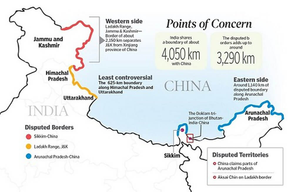
- On this graphic, the legend colours do not match the lines: red marks the Ladakh sector, yellow the Himachal–Uttarakhand sector and blue Sikkim and Arunachal Pradesh. Ladakh is now a Union Territory, and 3,488 km is the Ministry’s length.
Talks and Current Status
- Agreements: Peace and Tranquillity along the LAC (7 September 1993); confidence-building measures in the military field (29 November 1996); Political Parameters and Guiding Principles (April 2005).
- Sikkim: China dropped Sikkim from its list of countries on its official website in the early 2000s, a tacit recognition of that stretch.
- Package or sectors: China has floated a package deal (Aksai Chin to China, McMahon Line to India), while India prefers a sector-by-sector approach.
- 2020 standoff: a military standoff in eastern Ladakh. The patrolling arrangement of 21 October 2024 at Depsang and Demchok led to disengagement there.
- 25th Special Representatives’ talks (25 August 2026, Beijing): an Expert Group on boundary delimitation will pursue an “early harvest”, with two more military hotlines and meeting points. Border trade reopened at Lipulekh, Shipki La and Nathu La.
China’s Strategic Moves on the Border
- Water: on 19 July 2025 China began a five-cascade hydropower project on the lower Yarlung Tsangpo in Medog, at 1.2 trillion yuan, just before the river enters India as the Siang of the Brahmaputra.
- Older accounts describe the plan as a 38,000 MW Motuo dam and 28 Tibetan dams.
- India has conveyed its concern as a lower riparian. Flood-season data under the Brahmaputra agreement stopped after that agreement lapsed in June 2023.
- Rail and road: the Tibet railway to Lhasa and on towards Shigatse and Nyingchi, the Karakoram Highway through Pakistan-occupied Kashmir, and the proposed Kashgar–Gwadar link. India objects to anything crossing Indian territory.
- Sea: port projects at Chittagong, Hambantota and Kyaukpyu, and a naval presence on the oil routes through the Indian Ocean.
The India-Nepal Boundary
- Five States touch it: Uttarakhand, Uttar Pradesh, Bihar, West Bengal and Sikkim. It runs 1,751 km from the Tibet trijunction to Sikkim.
- It is a porous, open border with free movement of goods and people between India and Nepal.
- Most of it runs east-west along the foothills of the Shiwalik Range.
- Nepal is landlocked between India and China and balances between them. Both have built road links to Kathmandu.
Disputed Territories
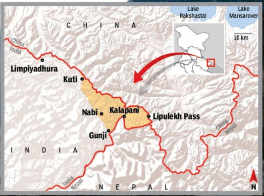
- Kalapani: a valley administered by India as part of Pithoragarh district, Uttarakhand, on the Kailash Mansarovar route.
- India’s political map of 2 November 2019 showed it as Indian territory. It is the historic Indian position that the area belongs to Uttarakhand.
- Nepal says it belongs to its westernmost part. In May–June 2020 Nepal issued a new map and amended its Constitution to claim Kalapani, Limpiyadhura and Lipulekh.
- India rejects this as “artificial enlargement”. It restated that stand in August 2025, when India–China trade through Lipulekh was agreed.
- The Kali River marks the border in this area.
- The Treaty of Sugauli, between the East India Company and Nepal after the Anglo-Nepalese War, fixed the Kali as Nepal’s western boundary.
- It was drawn up in December 1815 and ratified in March 1816, the date usually quoted.
- Dispute over the river’s true source lies behind the rival maps.
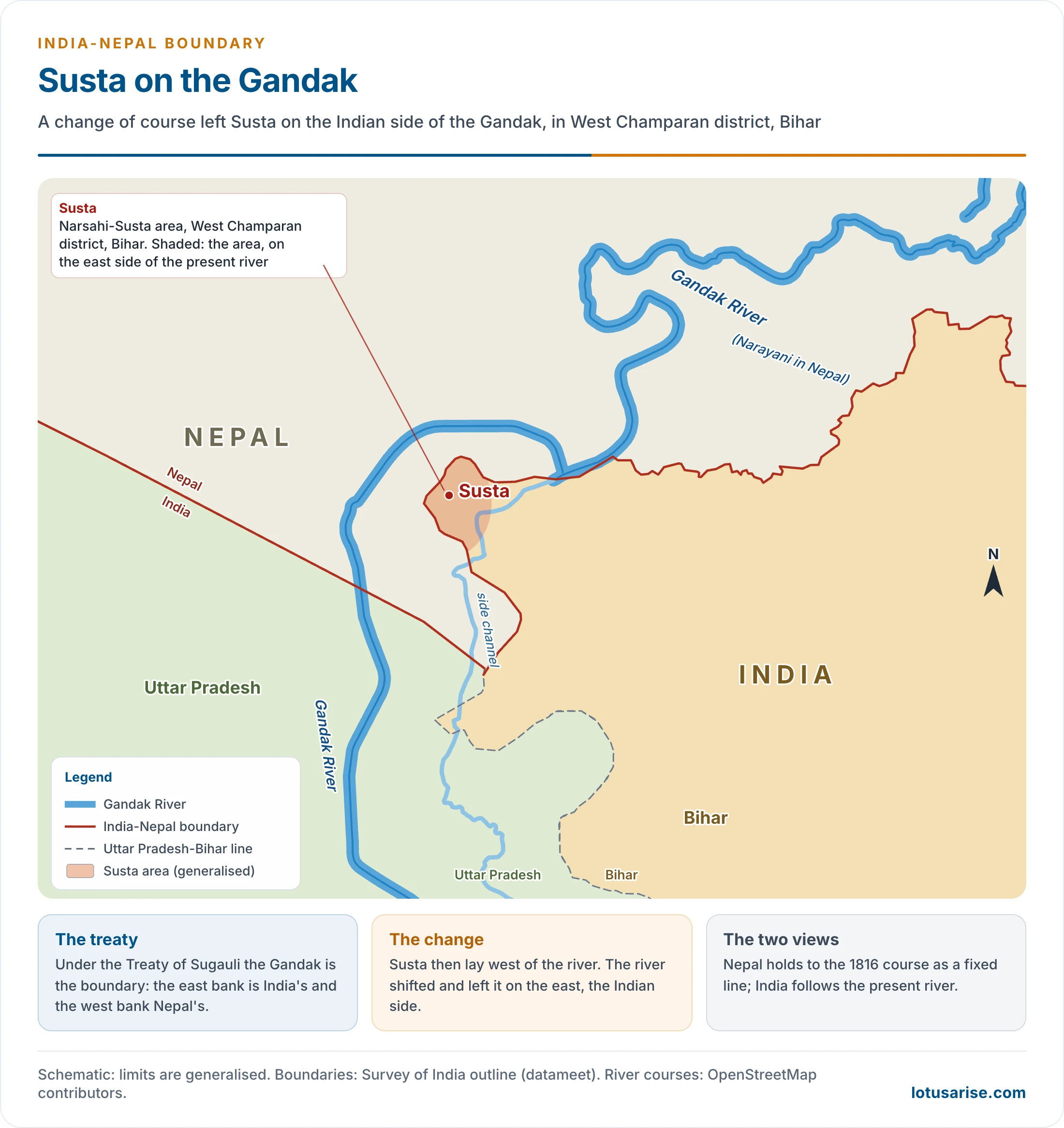
- Susta: a disputed area on the bank of the Gandak (called the Narayani in Nepal).
- Change of course by the river is the main cause.
- Under the treaty the Gandak is the boundary: the east bank is India’s and the west bank Nepal’s. Susta then lay west of the river, but the river shifted and left it on the east, the Indian side.
- It is often placed in Uttar Pradesh. Parliament’s record puts the Narsahi-Susta area in West Champaran district, Bihar, close to the Uttar Pradesh line.
- Nepal holds to the 1816 course as a fixed line; India follows the present river.
The India-Bhutan Boundary
- Quite peaceful, with no boundary dispute between the two. It runs 699 km along Sikkim, West Bengal, Assam and Arunachal Pradesh.
- Bhutan is a buffer between India and China. It joined the United Nations in 1971.
- Treaty: the 1949 Treaty of Friendship let India guide its foreign affairs. The 2007 revision removed that clause, and the two now cooperate closely on shared national interests.
- China and Bhutan: Bhutan’s northern border follows the Great Himalayan crest. China rejects the watershed principle and presses claims there.
- India protested those claims in 1959, on the basis of the treaty.
- Doklam, 2017: a 73-day standoff at the India–China–Bhutan trijunction, ended on 28 August 2017. India and Bhutan place the trijunction at Batang La, China at Mount Gipmochi. The plateau overlooks the Siliguri Corridor.
- Sakteng, 2020: China newly claimed Bhutan’s Sakteng Wildlife Sanctuary at a Global Environment Facility meeting. This is the sanctuary marked on the map below.

The Indo-Pakistan Boundary
- It came out of the 1947 Partition, through the Radcliffe Award, which takes its name from the chairman, Sir Cyril Radcliffe.
- Course: from the Rann of Kachchh through the Rajasthan desert, the Punjab plain and the hills of Jammu and Kashmir to the Karakoram.
- Character: a purely man-made boundary drawn on communal lines. In Punjab it slices through canals, railways, roads, fields, villages, towns and even shrines.
- Sectors: the Line of Control (LoC) runs about 740 km from near Sangam to NJ9842, beyond which the Actual Ground Position Line (AGPL), about 110 km, follows the Saltoro Ridge. Older accounts give 788 km and 150 km.
- Jammu and Kashmir and Sir Creek are the major disputed regions.

Disputed Territories
- Jammu and Kashmir, Pakistan-occupied Kashmir and Gilgit-Baltistan: Pakistan is in illegal and forcible occupation of about 78,000 sq km (78,114 sq km in fuller counts) of Indian territory. Under the so-called Sino-Pakistan Boundary Agreement of 1963, Pakistan illegally ceded 5,180 sq km in Pakistan-occupied Kashmir to China.
- The former State had 2,22,236 sq km and six distinct regions: the Kashmir Valley, Jammu, Gilgit, Baltistan, Punch and Ladakh.
- Accession: tribal raiders backed by Pakistan invaded on 22 October 1947, and Maharaja Hari Singh signed the Instrument of Accession on 26 October 1947. Kashmir thereby became legally part of India.
- Ceasefire: the United Nations commission proposed a plebiscite, conditional on Pakistan withdrawing its forces, which never happened. The ceasefire took effect on 1 January 1949; after the Shimla Agreement of 1972 the line became the LoC.
- Wars: 1947–48, 1965, 1971 and 1999 (Kargil).
- Strategic value: the region touches Pakistan, China and Afghanistan, and major rivers of Pakistan, the Indus, Jhelum, Chenab and Ravi, flow through or from it.
- Recent: on 31 October 2019 the State was reorganised into two Union Territories. After the Pahalgam attack of April 2025, India held the Indus Waters Treaty in abeyance, closed Attari–Wagah and carried out Operation Sindoor, with an understanding to stop military action reached on 10 May 2025. The attack belongs to the longer pattern of cross-border terrorism.
- Siachen Glacier: in the eastern Karakoram, just east of the Actual Ground Position Line between India and Pakistan.
- Size: about 76 km long, the second-longest glacier outside the polar regions after Fedchenko. Older accounts call it the largest and give 75 km and 450 sq km.
- Origin of the dispute: the LoC stops at NJ9842. The 1949 Karachi Agreement ran the line “thence north to the glaciers”, with nothing beyond. Pakistan extends it north-east to the Karakoram Pass; India follows the Saltoro watershed.
- The entire glacier, with all major passes (Sia La, Bilafond La, Gyong La), has been under India’s administration since Operation Meghdoot, 13 April 1984. It is the world’s highest battlefield, and it feeds the Nubra, a tributary of the Shyok and so of the Indus.
- It ranks first among the important glaciers of India for its length.
- Saltoro Ridge: a sub-range of the Karakoram, in its heart, on the south-west side of the Siachen Glacier.
- India holds it as part of the Union Territory of Ladakh (Jammu and Kashmir before 2019), and Pakistan claims it as part of Gilgit-Baltistan.
- In 1984 India took military control of its main peaks and passes, leaving Pakistani forces in the glacial valleys to the west.
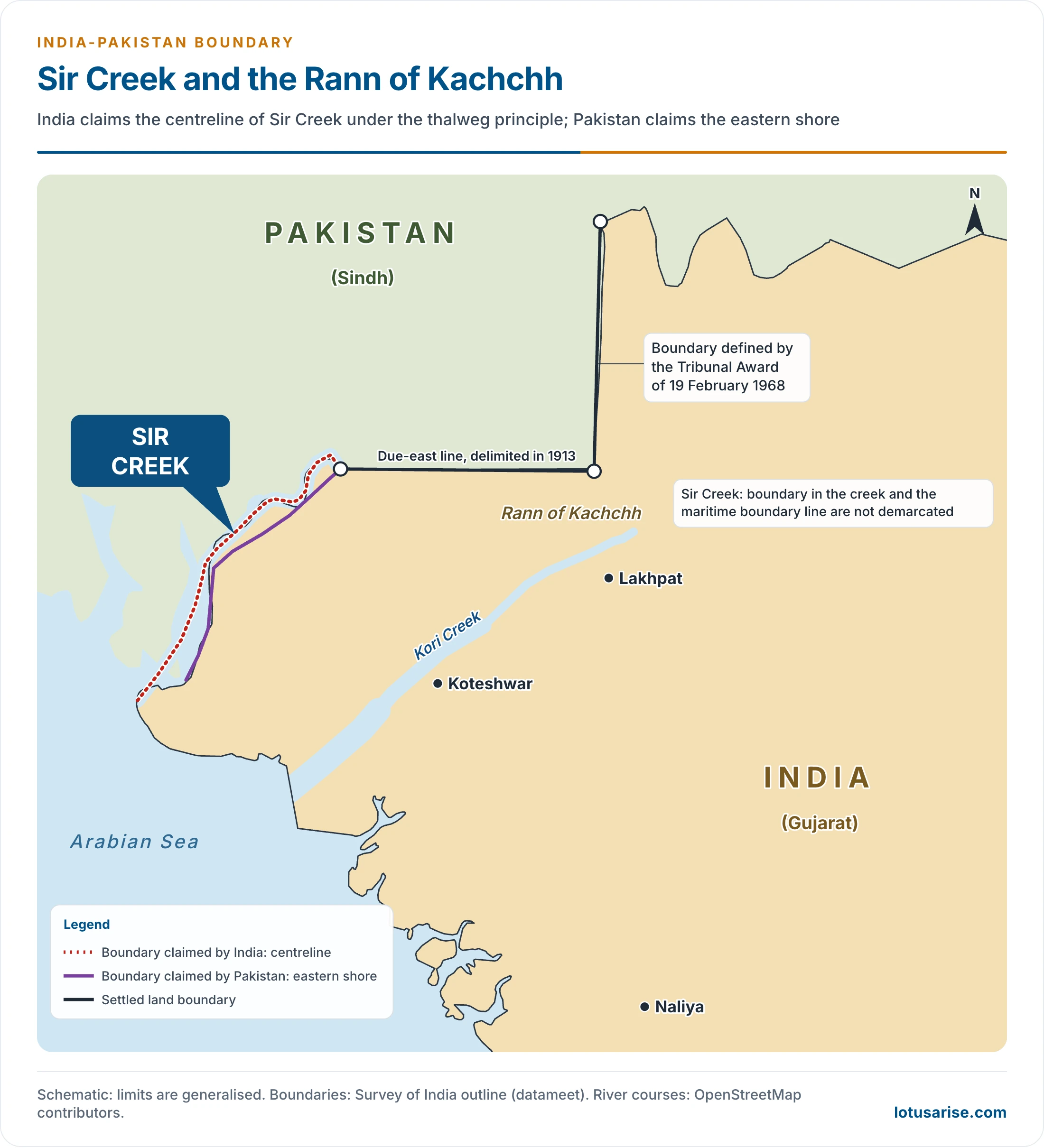
- Sir Creek: a 96 km strip of water in the Rann of Kutch marshlands, between Gujarat and Sindh. Its value lies in the fishing and oil prospects and the sea boundary that depend on it.
- Pakistan claims the line along the eastern shore of the estuary, and India claims a centreline, under the thalweg principle. The two rely on differing readings of paragraphs 9 and 10 of the Bombay Government Resolution of 1914, between the then Government of Sindh and Rao Maharaj of Kutch.
- The International Boundary in the Sir Creek area and the International Maritime Boundary Line (IMBL) have not been demarcated.
- Rann of Kachchh (settled): India held the Rann to be a marsh and part of Kachchh. Pakistan called it a landlocked sea to be shared, and claimed about 3,500 square miles (about 9,065 sq km).
- After fighting in 1965, the dispute went to a tribunal chaired by Gunnar Lagergren, set up under the agreement of 30 June 1965 and not by the International Court of Justice.
- Its award of 19 February 1968 gave Pakistan about a tenth of the claim (906.5 sq km). It left out Sir Creek, and demarcation ended in 1969.
- Links opened in the 2000s (the Srinagar–Muzaffarabad and Amritsar–Lahore buses, Munabao–Khokrapar rail, LoC trade, meeting points for families) did not survive later tensions.

The India-Bangladesh Border
- India’s 4,096.7 km border with Bangladesh is the longest, about 27 per cent of the land border. West Bengal has much the longest stretch, over 2,200 km, followed by Tripura, Meghalaya, Mizoram and Assam.
- It was fixed by the Radcliffe Award, which divided the former province of Bengal in two. It became Bangladesh’s border in 1971.
- Character: it crosses the flat Ganga-Brahmaputra delta, with hardly a hill to mark it, so it separates very little of the population on the two sides. Shifting rivers keep moving it.
- Early overlapping claims:
- Ganga channel: Rajshahi against Murshidabad.
- Mathabhanga: Karimpur against Daulatpur, settled on a midstream line.
- Sylhet against the Garo, Khasi and Jaintia Hills, which are densely forested.
- Land Boundary Agreement: the 1974 Agreement and 2011 Protocol took effect through the 100th Constitutional Amendment (May 2015).
- At midnight on 31 July 2015, 111 Indian enclaves (17,160.63 acres) went to Bangladesh and 51 Bangladeshi enclaves (7,110.02 acres) came to India.
- The 6.1 km undemarcated stretches were settled: Daikhata-56 (West Bengal), Muhuri River–Belonia (Tripura) and Lathitila–Dumabari (Assam).
- Territories in adverse possession stayed with their holders.
- Tin Bigha Corridor: leased so that Bangladesh can reach its Dahagram–Angarpota enclave, and open 24 hours since 2011.
- Water: Farakka Barrage on the Ganga, built to flush the Hugli and protect Kolkata port, led to the 1996 Ganga Water Treaty, which expires in 2026. Teesta sharing remains unsettled, along with the Feni, Manu, Muhuri, Khowai, Gumti, Dharla and Dudhkumar, among the river water disputes with neighbours.
- Migration and fencing: illegal migration into Assam, Tripura and West Bengal has made border fencing a sore point.
- Transit: the narrow Siliguri Corridor (Chicken’s Neck) in north Bengal is the North-East’s only land link with the rest of India. This raises the value of transit through Bangladesh, and of the alternative below through Myanmar.


- This graphic dates from 2011. The swap has since taken place, the enclaves went as listed above, and the current border length is 4,096.7 km, not the 3,909 km it shows.
India-Myanmar Boundary
- Length: 1,643 km (older figure 1,458 km), from the China trijunction to the Bangladesh trijunction, along Arunachal Pradesh, Nagaland, Manipur and Mizoram.
- It broadly follows the divide between the Brahmaputra and the Ayeyarwady (Irrawaddy).
- It crosses thickly forested hills. India’s side has the Mizo Hills, Manipur and Nagaland; Myanmar’s side has the Chin Hills, Naga Hills and Kachin State.
- History: the Treaty of Yandabo (1826) opened the way. The boundary agreement was signed on 10 March 1967.
- Barriers: the hills are low, rarely above 3,000 m, but forest, heavy rain and swift rivers made this frontier hard to cross, so few invaders came this way.
- Free Movement Regime: border tribes could move 16 km either side without a visa. India decided to scrap it in February 2024, cut the limit to 10 km from December 2024, and is fencing the whole border, against Naga and Kuki-Zo objection.
- Connectivity: the Kaladan Multi-Modal Project (Kolkata by sea to Sittwe, up the Kaladan to Paletwa, then by road to Mizoram) bypasses the Chicken’s Neck. The Trilateral Highway links India with Myanmar and Thailand, with extension to Cambodia and Vietnam proposed. Moreh–Tamu is the main land crossing.
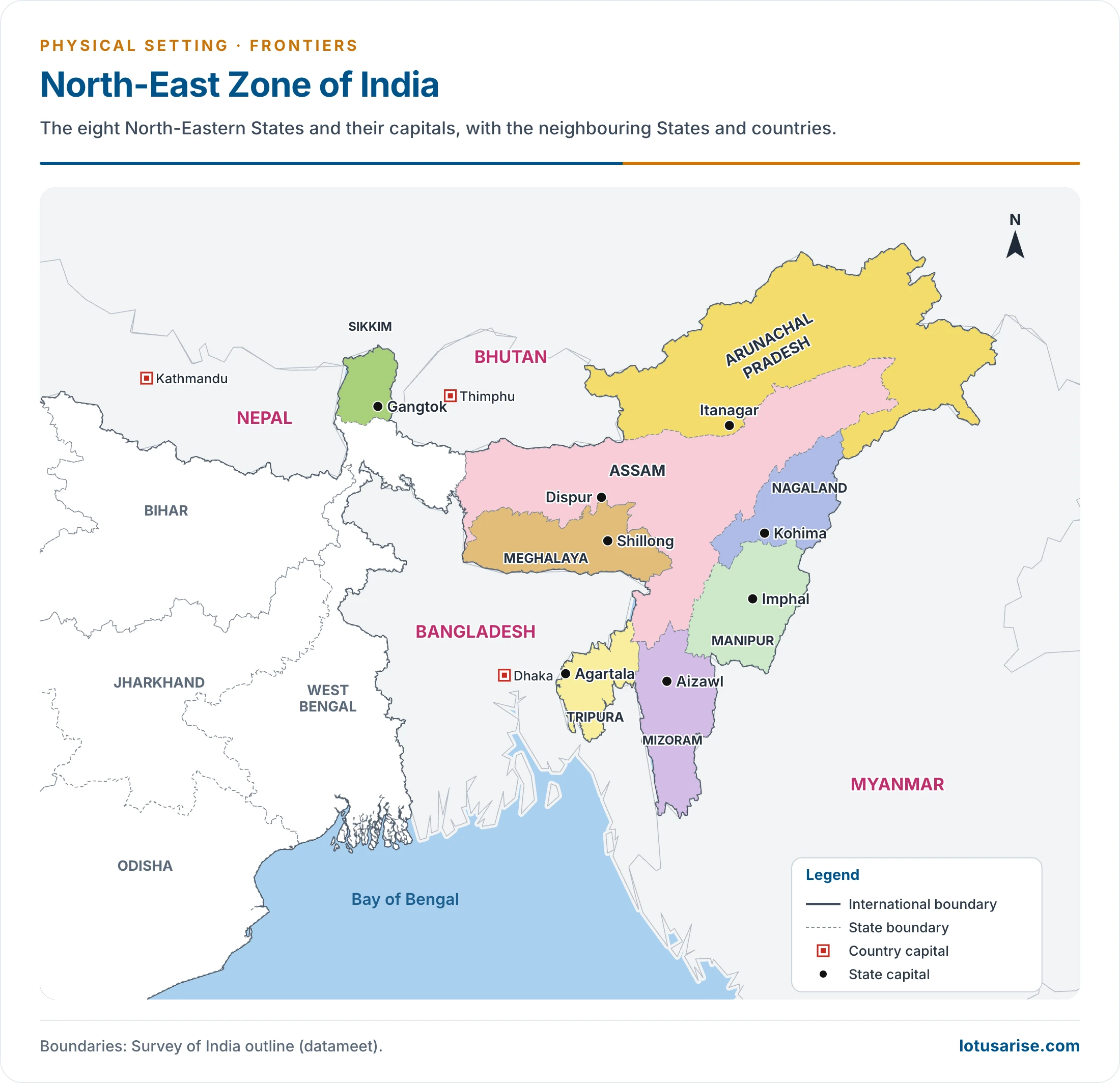
- Drugs: the border lies next to the Golden Triangle (Myanmar, Laos, Thailand). The Golden Crescent (Afghanistan, Iran, Pakistan) lies to the west, so India sits between the two main opium belts.

- This map also tags Vietnam, but the Golden Triangle is Myanmar, Laos and Thailand. “Burma” is now Myanmar.
Water Frontiers
Coastline of India
- India is bounded by the sea on three sides.
- Length: the figure of 7,516.6 km dates from the 1970s, and was made up of about 6,100 km of mainland coast plus the coast of 1,197 islands, touching 13 States and Union Territories.
- Revised length: 11,098.81 km. The National Hydrographic Office and Survey of India re-measured it, and the Ministry of Ports, Shipping and Waterways issued it on 29 April 2025.
- Why it grew: a larger map scale (1:250,000 against about 1:4,500,000), GIS tools, and the coasts of offshore islands. No land was gained. A larger scale picks up bays and inlets that a smaller one smooths away.
- Islands: now reconciled at 1,298 offshore islands and islets (1,059 islands, 239 islets).
- Review: every 10 years.
| State or UT | Old (km) | Revised (km) |
|---|---|---|
| Gujarat | 1,214.7 | 2,340.62 |
| Tamil Nadu | 906.9 | 1,068.69 |
| Andhra Pradesh | 973.7 | 1,053.07 |
| Maharashtra | 652.6 | 877.97 |
| West Bengal | 157.5 | 721.02 |
| Keralam | 569.7 | 600.15 |
| Odisha | 476.4 | 574.71 |
| Karnataka | 280 | 343.3 |
| Goa | 160.5 (with Daman and Diu) | 193.95 |
| Daman and Diu | 54.38 | |
| Puducherry | 30.6 | 42.65 |
| Lakshadweep | 132 | 144.8 |
| Andaman and Nicobar Islands | 1,962 | 3,083.5 |
| Total | 7,516.6 | 11,098.81 |
- Gujarat stays the longest State; Andhra Pradesh falls to third. The Andaman and Nicobar Islands have the longest coast of any unit, and West Bengal gains the most in proportion.
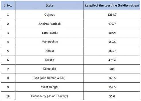
- These are the old lengths, for the mainland units only, and they add up to 5,422.6 km and not the 6,100 km quoted officially.
- The present coastline owes its shape to faulting and to emergence and submergence.
Coastal Plains
- The coastal plains run along the east and west of the country, and fall into two groups.
| Feature | Eastern Coastal Plains | Western Coastal Plains |
|---|---|---|
| Stretch | West Bengal to Tamil Nadu, through Odisha and Andhra Pradesh | Gujarat to Keralam, through Maharashtra, Goa and Karnataka |
| Width | Wider, about 120 km on average | Narrower: 1,500 km long, old figure 10–25 km wide, up to about 96 km in Keralam |
| Rivers | Large deltas: Mahanadi, Godavari, Krishna, Cauvery | Short streams, few deltas |
| Coast | Lagoons such as Chilika and Pulicat | Lagoons in Malabar; shelf widest off Mumbai |
| Divisions | Three | Four |
Eastern Coastal Plains of India
- The deltas are very fertile and productive. The name “Granary of South India” is given to the Krishna delta and also to the Cauvery delta.
- Chilka Lake and Pulicat Lake, both lagoons, are the key features of this coast.
- It has three divisions:
- Utkal coast: the coast of Odisha, holding the Mahanadi delta and Chilika. It is sometimes extended from Chilika to Kolleru, but Kolleru lies well inside Andhra Pradesh. Much wider than the western plains, with heavy rainfall. Crops: rice, coconut and banana.
- Andhra coast: south of Utkal to Pulicat Lake, with Kolleru Lake in the middle. It holds the basin of the Krishna and Godavari.
- Coromandel coast: Pulicat Lake to Kanyakumari in Tamil Nadu. It stays dry in summer and gets rain in winter from the north-east monsoon.
Western Coastal Plains of India
- The Western Continental Shelf is widest off Mumbai (Bombay), an area rich in oil. The Malabar lagoons are a tourist draw.
- It has four divisions:
- Kachchh and Kathiawar coast: Kachchh, formerly a gulf, was filled by silt of the Indus. It lies under shallow water in the monsoon, and divides into the Great Rann (north) and Little Rann (east). Kathiawar lies south of Kachchh.
- Konkan coast: Daman to Goa. Crops: rice and cashew.
- Kanada coast: Marmagao to Mangalore, rich in iron deposits.
- Malabar coast: Mangalore to Kanyakumari, relatively broad, with lagoons parallel to the shore in southern Keralam.
- In loose use, Konkan means the Maharashtra and Goa coast, and Malabar the Keralam and Karnataka coast. Strictly, the Karnataka stretch is Kanada.
Seas and Maritime Limits
- Next to the Himalaya, the Indian Ocean has done most to shape India. It carried early trade, and the monsoon forms over it.
- Security: the sea was long thought safe. Modern naval warfare has made these frontiers vulnerable, and defence planning now has to reckon with them.
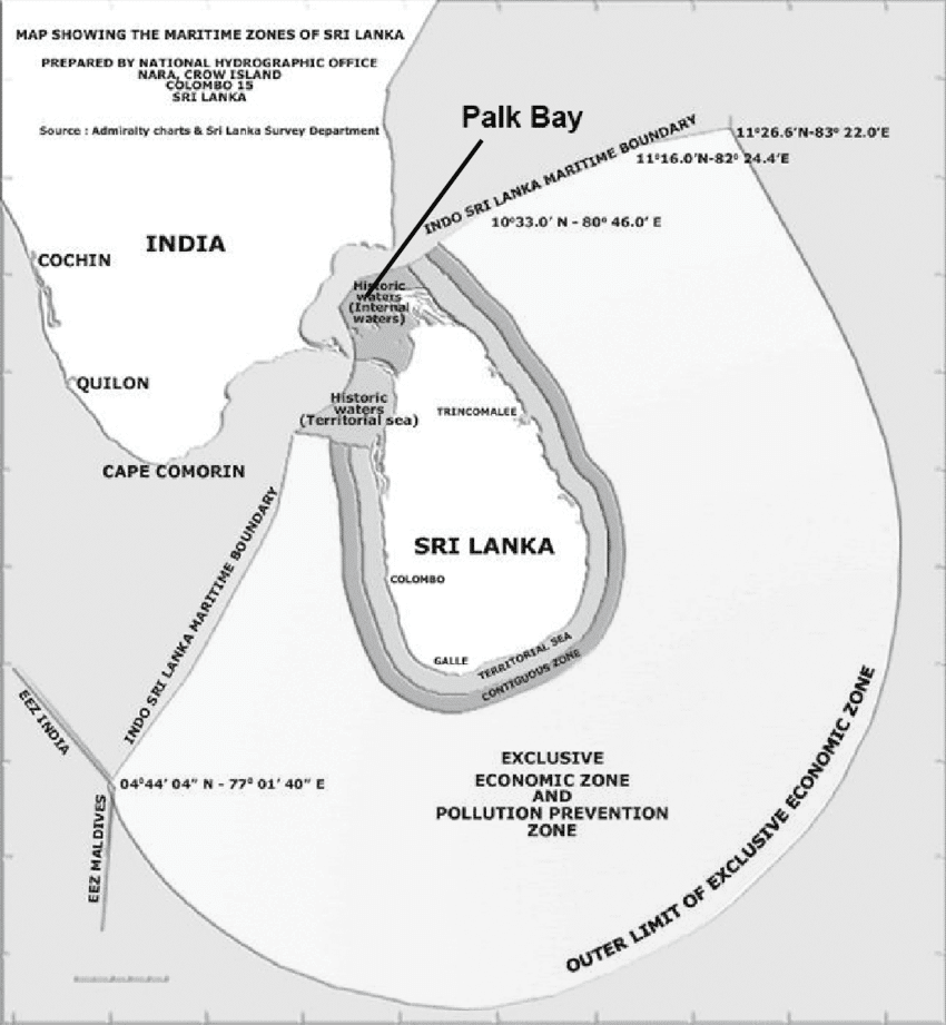
- Maritime zones (Act of 1976): territorial sea of 12 nautical miles and an exclusive economic zone of 200 nautical miles.
- Seven maritime neighbours: Pakistan, Maldives, Sri Lanka, Indonesia, Thailand, Myanmar and Bangladesh.
- Agreed: Sri Lanka (1974, 1976), Maldives (1976), Indonesia (1974, 1977), Thailand (1978, 1993), Myanmar (1986).
- Bangladesh: settled by an arbitral award of 7 July 2014, under the Law of the Sea Convention.
- Pakistan: still open, because of Sir Creek.
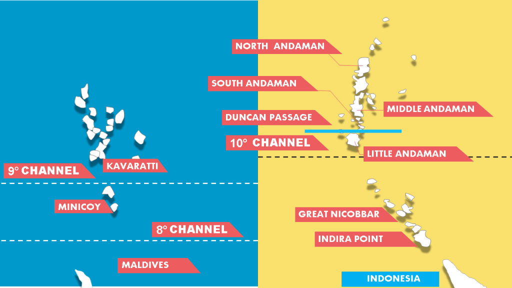
- Channels shown above:
- Eight Degree Channel: Minicoy from the Maldives.
- Nine Degree Channel: Minicoy from the main Lakshadweep group, with Kavaratti.
- Ten Degree Channel: Little Andaman from Car Nicobar.
- Duncan Passage: South Andaman from Little Andaman.
- Together these channels divide the island groups of India.
India-Sri Lanka Boundary
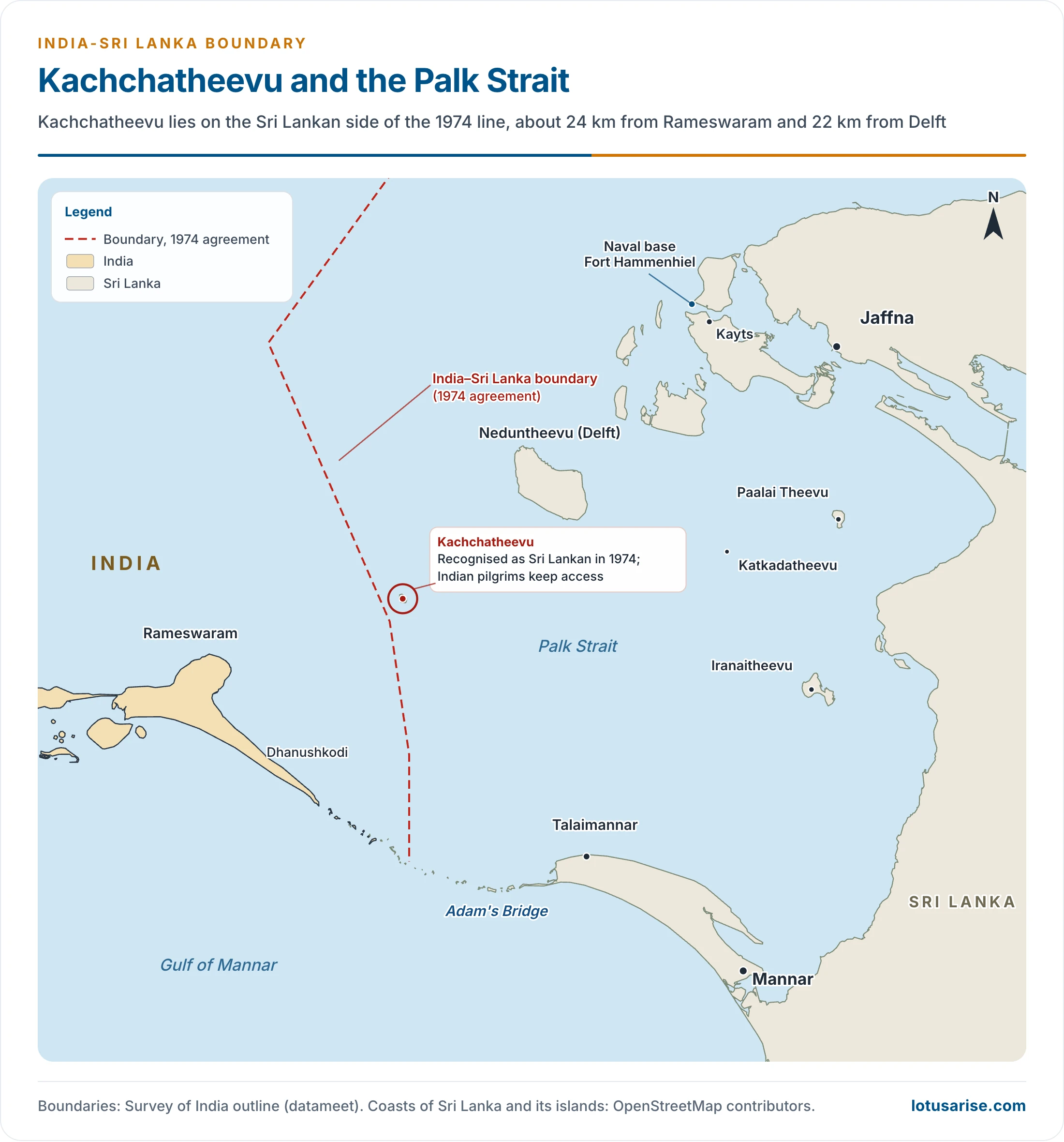
- A narrow, shallow sea, the Palk Strait, lies between India and Sri Lanka.
- From Dhanushkodi in Tamil Nadu to Talaimannar is only 32 km, and a chain of islets, Adam’s Bridge, joins them. Talaimannar is on Mannar Island, though it is often placed in the Jaffna peninsula.
- Kachchatheevu: peace has largely prevailed, but ownership of this island in the Palk Strait raised tension.
- Size: about 285 acres and 1.6 km long, uninhabited but for St Anthony’s church. Older accounts give 1.92 sq km.
- Distance: about 24 km (15 miles) from Rameswaram and about 22 km from Delft Island, not the 16 km sometimes given.
- 1974: India recognised it as Sri Lankan under the agreement on the boundary in historic waters, which keeps access for Indian pilgrims.
- 1976: the Gulf of Mannar and Bay of Bengal agreement and an exchange of letters closed fishing by either side in the other’s waters, the root of today’s fishermen issue.
- Other ties: the North and North-East of the island hold many Tamils, and the LTTE insurgency from the 1980s made this sea line active.
Strategic Position, Routes and Unity
Strategic Significance
- Location: India occupies the head of the Indian Ocean, close to the centre of the Eastern Hemisphere, and trade routes fan out from it.
- It is the only ocean named after a country, and India’s long coast faces it directly.
- Sea routes between Europe and East Asia must pass close to its shores, and many air routes between West and East cross it.
- Outlets: the ocean opens through narrow gates: the Red Sea and Persian Gulf in the west, and the Strait of Malacca and the seas around Indonesia and Australia in the east.
- Sea power: Kavalam Madhava Panikkar (1945) argued that whoever rules the sea rules the adjoining land, drawing on the British case. Rivalry after Britain’s withdrawal, the Lusaka call of 1970 for a zone of peace, and bases such as Diego Garcia shape the geopolitics of the Indian Ocean.
- Links with the Oriental World: India’s main contacts with East Africa and West, South and South-East Asia have long been by sea. Hinduism and Buddhism spread by these routes, and Bali and Thailand keep their traces.
Routes into India
- The mountain wall isolates but does not seal the country. Traders, settlers and invaders have long crossed the passes.
| Frontier | Passes and routes | Effect |
|---|---|---|
| High north | Muztagh, Karakoram, Chang Chenmo (above 6,000 m) | Little contact |
| Himalaya | Burzil, Zoji La; Bara Lacha La, Shipki La; Niti, Lipu Lekh; Nathu La, Jelep La | Crossing the main range |
| North-west | Khyber, Malakand, Tochi, Gomal, Kohat, Bolan | Main way in for migrants and invaders |
| East | River gaps towards Myanmar; Moreh–Tamu road | Few crossings |
| Sea | Indian Ocean | Trade outward; no large power from the sea until the Europeans |
- The natural frontier in the north-west lies well beyond the present line, along the Hindukush, Safed Koh, Sulaiman and Kirthar ranges. The line drawn in 1947 is artificial.
Diversity and Unity
- Physical contrasts:
- Relief: the old, stable Plateau against the young Himalaya and the Great Plains.
- Rivers: snow-fed and perennial in the Himalaya; rain-fed and seasonal on the Peninsula.
- Temperature: about −40°C on winter nights at Dras, against 48–50°C on summer days at Barmer.
- Rainfall: over 1,200 cm at Mawsynram, against about 12 cm at Jaisalmer.
- Vegetation: evergreen forest in the Western Ghats and the North-East, and thorn scrub in the Thar.
- Human contrasts: a mosaic of religions, languages and economies, from empty Ladakh to the crowded deltas. Hence the phrase “epitome of the world“.
- Unifying forces:
- The monsoon rhythm and the farming cycle tied to it.
- The Great Plains linking north and south.
- Shared cultural traditions, such as the Ramayana and Mahabharata, and a composite Hindu–Muslim culture.
- A national market, in which tea from Assam, wheat from Punjab, minerals from Chotanagpur and southern spices circulate, helped by transport links.
- Land of potentialities: rich in iron ore, manganese, water and fertile land, and with a huge population, though it is not yet fully able to use them. Hence the old description of a rich country peopled by the poor.
Previous Year Questions
2026With reference to the international boundary between India and Bangladesh, discuss the related issues and challenges.2025With reference to international boundaries of India, discuss the related issues, giving suitable examples.2022The Kalapani dispute has opened a new front on the India-Nepal international border. Explain.2018Is the land boundary of India with its neighbouring countries a cultural divide or divided culture? Explain with suitable examples.2017Bring out the geopolitical implications of the Doklam dispute in the context of Indo-China relations.2016Mention the space relationship of India with neighbouring countries.2016Explain the origin, dimension and implications of the Sino-Indian border dispute.2014Bring out the role of terrain in determining India’s political influence over neighbouring countries.2014Discuss the implications of India’s strategic location with reference to the Indian Ocean.2014India is involved in a number of border disputes. Explain the reasons and remedies.2012Examine the origin, dimensions and implications of the Sino-Indian border dispute.2004Write an essay on the origin, dimensions and implications of Sino-Indian border dispute.2001Discuss the geopolitical importance of India’s Land Boundaries.1992Write short note: Major issues involved in the Sino-Indian boundary conflict.1991Discuss the political issues involved in the ‘Tin Bigha’ or Siachen dispute.1990Write short note: The international boundary of India and related issues.1988Write short note: The Sino-Indian Boundary.1988Give the geographical bases of unity and diversity in India.





Sir very good content and very well organized too.
One correction sir – Susta area is in West Champaran(Bihar)
Note : (correct me please if i am wrong sir)
Thanks for your kind words. I have included the map, See the map.
How can i download free
Sir, please provide the remaining notes of Geography optional
Okay
I think there is mistake ,it’s not McDonald line it’s a Mac Mohan line
Read here – https://en.wikipedia.org/wiki/Macartney%E2%80%93MacDonald_Line
Sir can I get the PDFs for the same..please.
Please guide me how can I contribute for this lovely efforts 😊
VERY GOOD CONTENT. ONE STOP SOLUTION.
Vy impressive… I fully understand
Thank you for such a perfect website! Everything is perfect however, there is a small correction that you/your team can make. The border with China is not updated. Laddakh took place of Jammu & Kashmir in sharing the border with China, and that too as an Union territory and not as an State.
Dear sir, I want to know this content enough or not for upsc exam?
Thank you so much sir for these very useful contents. 🙏🙏
thank you so much sir
Sir Cauvery river Delta is known as Granary of South India
Correct me if I am wrong
You are right