

- Geopolitics is the shaping of political strategy from geographical facts such as location, routes, resources and terrain, in order to win special political or economic advantage. It belongs to the wider field of political geography.
- South Asia and the Indian Ocean realm have gained geopolitical weight because of their strategic location.
- The ocean joins Africa, West Asia, South Asia, South-East Asia and Australia, and carries the energy and trade of distant economies.
- South Asia sits at the head of that ocean, with India at its centre by land and by sea.
The Indian Ocean and India
India’s Stake in the Ocean
- Position: India has a long coastline on the ocean and the largest population and economy among the states resident on its shores. Together these give it a leading place in the region.
- Coast: long given as 7,516.6 km, and re-assessed in 2025 at 11,098.81 km.
- Economy: India’s GDP for 2026 is about US$ 4.06 trillion against Australia’s US$ 2.11 trillion (IMF, October 2026). Australia, however, is larger by area.
- Peace and resources: India’s concern, past and present, is to keep the ocean peaceful, to prevent unauthorised incursions, and to protect its mineral resources from exploitation by other countries.
- Maritime zones: a territorial sea of 12 nautical miles and an exclusive economic zone of 200 nautical miles under the Act of 1976, within the Law of the Sea Convention.
- Deep seabed: India was the first registered pioneer investor (1987). An early allotment of 1,50,000 sq km has since narrowed to a contract for 75,000 sq km of the Central Indian Ocean Basin.
- Sulphides: the International Seabed Authority contracts cover 10,000 sq km on the Central and Southwest Indian ridges (2016) and 10,000 sq km on the Carlsberg Ridge, signed on 15 September 2025.
- China’s navy: the growing naval ambitions of China and its rising presence at overseas bases and ports pose a military challenge to India.
- Nuclear neighbours: Pakistan and China both hold nuclear weapons, which has pressed India towards a sophisticated nuclear defence system and a second-strike capability.
- Doctrine: under its no-first-use policy, India’s deterrent rests on surviving a first strike. Ballistic missile submarines provide the sea-based leg of that deterrent.
- Fleet: INS Arihant (2016), INS Arighaat (August 2024) and INS Aridhaman, commissioned at Visakhapatnam on 3 April 2026.
- Oil and gas: India’s growing reliance on West Asian energy gives it a direct interest in peace and stability there. Crude import dependence stood at 88.7% in 2025-26.
Three Sets of Factors
- The geographical and political causes behind the ocean’s importance fall under three heads:
- The strategic location of the Indian Ocean.
- The dynamics of the Cold War.
- Concerns of the post-Cold War era.
Strategic Location
- Size and name: the third largest ocean, about 70.6 million sq km, against an older figure of about 73.4 million sq km. It is the only ocean named after a country.
- Limits: Asia closes it in the north, so it is land-locked on that side. Its conventional limits with the Atlantic and Pacific run along 20°E from Cape Agulhas and about 147°E from Tasmania. A forked mid-ocean ridge system divides its floor.
- Meeting of three oceans: it joins the Atlantic and the Pacific in the south, and many coastal states line its shores.
- 46 countries surround it on the United Nations count usually quoted: 27 littoral (including Australia), 12 landlocked and 7 island states.
- It acts as a bridge between east and west, linking Europe with Asia, Asia with North America and Asia with Africa.
- Antarctica: the ocean reaches south to the Antarctic coast, and the continent was long seen as an untapped store of future opportunity.
- The Madrid Protocol, signed on 4 October 1991 and in force since 14 January 1998, bans mineral activity there except for science. A review becomes possible from 2048.
- India’s interest is so far scientific, through its Maitri and Bharati stations.
- Persian Gulf: the ocean’s nearness to this hydrocarbon-rich basin adds to its geopolitical value.
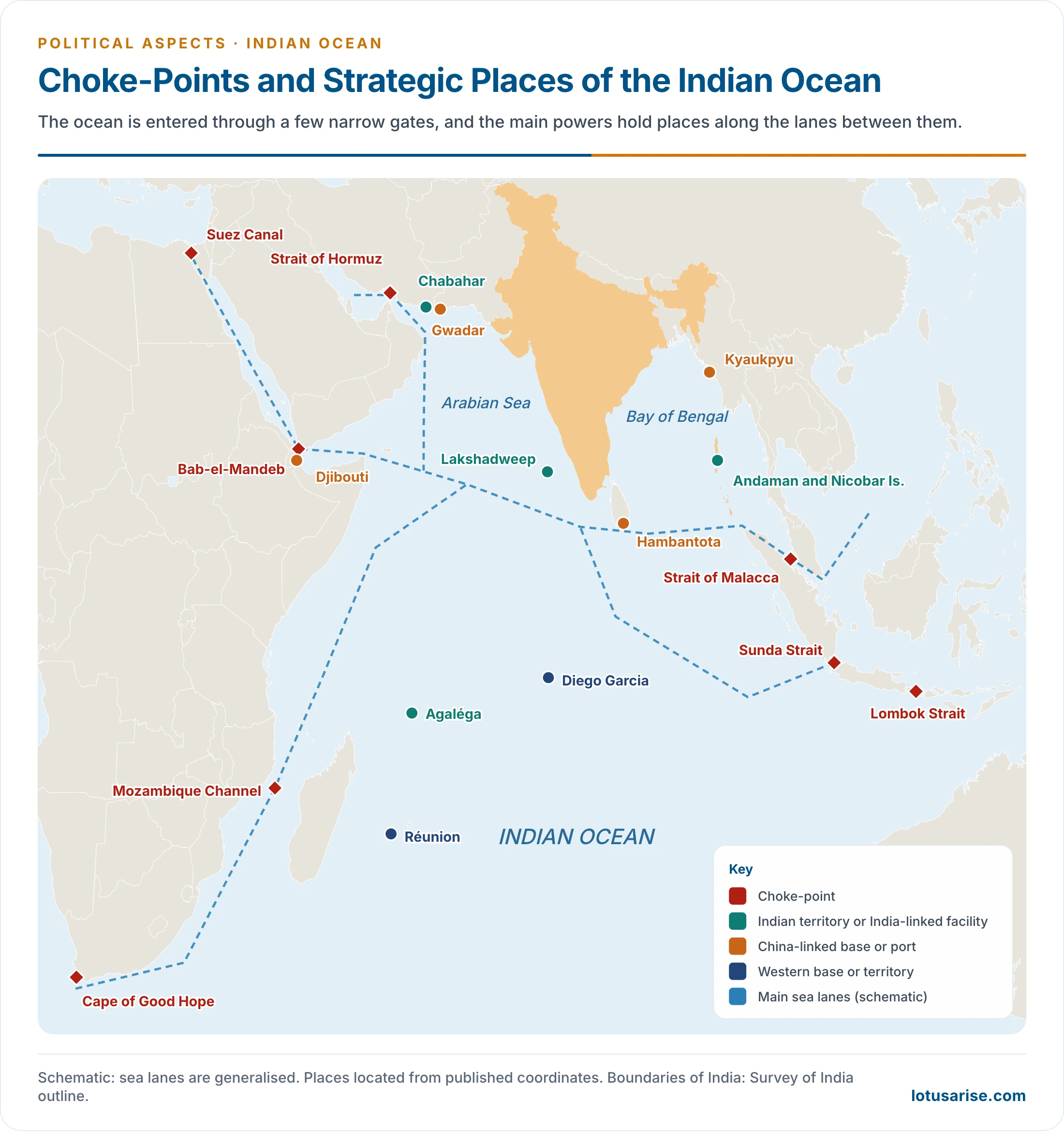
- Narrow gates: the ocean is entered mainly through narrow passages, each a potential choke-point. Bab-el-Mandeb and Hormuz lie in the west, and Malacca lies in the east.
| Gate | Joins or lies between | Geopolitical weight |
|---|---|---|
| Strait of Hormuz | Persian Gulf and Gulf of Oman | Gulf oil and gas; India’s crude and LPG |
| Bab-el-Mandeb | Red Sea and Gulf of Aden | Route to Suez, open since 1869, and Europe |
| Strait of Malacca | Andaman Sea and South China Sea | East Asian trade and oil; close to the Andaman and Nicobar Islands |
| Sunda and Lombok | Java Sea and Indian Ocean | Alternatives to Malacca through Indonesia |
| Mozambique Channel | Africa and Madagascar | Route round southern Africa |
| Cape of Good Hope | Indian and Atlantic oceans | The only western link before 1869; again in use during Red Sea attacks |
- India at the head of the ocean: its peninsula reaches about 1,600 km into the water and parts it into the Arabian Sea and the Bay of Bengal.
- East-west sea lanes run close to its shores, and many air routes between Europe and East Asia cross it.
- About 95% by volume and 70% by value of India’s trade moves by sea (2026).
- That central place once made India the great entrepôt of ocean trade, which drew West Asian and European traders to it.
- Resources: the wealth of the ocean floor and its rim is itself a source of rivalry.
| Resource | What it is | Where |
|---|---|---|
| Aggregates | Sand, gravel and shell, for construction and cement | Continental shelves |
| Placers | Heavy minerals concentrated by erosion: titanium, tin, thorium-bearing monazite | Sri Lanka, India, Australia, Malaysia, Indonesia |
| Polymetallic nodules | Manganese, copper, nickel and cobalt | Deep basins, notably the Central Indian Ocean Basin |
| Phosphorite | Phosphate for fertiliser, on margins and upper slopes | Arabian coast, east coast of India, Andamans, south of Sri Lanka, Agulhas Bank |
| Oil and gas | Offshore fields on the shelves | Persian Gulf, Mumbai High, Krishna-Godavari, Indonesia, Malaysia, Western Australia |
Sea Power in History
- Early Indian links: Mauryan ports worked the Bay of Bengal, Kautilya’s Arthashastra provides for sea affairs, and the Cholas built a naval power. The Sumatran empire of Srivijaya traded closely with South India between the 8th and 11th centuries.
- Arabs and Europeans: Arab traders dominated the Arabian Sea before Vasco da Gama reached Calicut in 1498. European rivalry followed, and Britain won supremacy, developing Mumbai, Kolkata and Chennai as ports.
- Kavalam Madhava Panikkar (1945) drew the lesson that whoever commands the sea will in time command the land beside it.
- Earlier conquerors who came by land were absorbed into India. The British stayed apart because naval supply lines tied them to home.
- Japan’s seizure of Singapore and the Andamans in 1942 pointed the same way.
- The argument echoes the sea power thesis of Alfred Thayer Mahan.
- The vacuum: decolonisation shrank British power, and in January 1968 London announced its withdrawal from east of Suez. The rivalry that followed filled the space.
Cold War Dynamics
- First phase: ideology and bases. Geopolitics in the realm began with the division of the world into camps of capitalism and communism.
- The USA and the USSR overshadowed colonial powers such as Britain, France and the Netherlands in South Asia and the Indian Ocean.
- Diego Garcia: Britain carved out the British Indian Ocean Territory (BIOT) from Mauritius and Seychelles on 8 November 1965, and made it available to the USA under an agreement of 30 December 1966. The USA built a full naval and air base, to guard West Asian oil and serve its Cold War defence.
- Each superpower sought as many bases as it could in West Asia and north-eastern Africa, to deny the other strategic and military superiority.
- Soviet ships first toured the ocean in March 1968, and work on a Soviet support facility at Berbera in Somalia began in October 1972.
- Second phase: new weapons. Submarine-launched ballistic missiles changed the calculation, and from the 1960s both powers acquired naval and air bases to fit a global defence strategy built on them.
- Zone of Peace: rising superpower rivalry produced the idea of keeping the ocean free of great-power contest.
- The Non-Aligned summit at Lusaka (1970) called for it. Sri Lanka proposed it at the United Nations General Assembly, which adopted Resolution 2832 on 16 December 1971 by 61 votes to none, with 55 abstentions.
- An Ad Hoc Committee followed in 1972, and the item remains on the Assembly’s agenda, most recently in Resolution 80/13 (2025).
- The superpowers stood aside. They also wanted the coastal states to accept the zone’s conditions, which would have made it harder for countries such as India to develop nuclear weapons and advanced missiles.
- Some littoral states withheld support, fearing that India would rise to dominance once the outside powers had left.
- Third phase: China. China’s growing military and economic strength, especially in the 1980s, worried South-East Asian states, which wanted a continuing US presence.
- ASEAN itself dates from 8 August 1967. Its Bangkok Declaration names economic growth, social progress, cultural development and regional peace as aims, and it took shape amid Cold War fears of communist expansion.
- Net effect: Cold War rivalry and Middle Eastern oil security were the two foundations of the ocean’s geopolitics in this era.
Post-Cold War Concerns
- Thaw: easing relations between the USA and the USSR reshaped the realm.
- The Intermediate-Range Nuclear Forces Treaty was signed on 8 December 1987, and START I on 31 July 1991.
- The Cold War wound down by about 1990, and the USSR broke up in 1991.
- Three factors then rose to the front:
- China’s military posture in the Taiwan Strait and the Spratly Islands alarms South-East Asian states and also the Korean peninsula and Japan. These countries press for a US presence to balance Chinese power.
- Energy security of the West, and of industrial economies such as Japan, requires peace in the Persian Gulf and around it.
- The Carter Doctrine of January 1980 declared the Gulf a vital US interest. It led to the Rapid Deployment Joint Task Force (1 March 1980), a versatile force able to step directly into a Gulf crisis, and to Central Command (1 January 1983).
- The Gulf War of 1990-91 made the ocean a focus of world politics.
- International terrorist groups active in the region bordering Afghanistan and Pakistan have added to the strategic importance of the ocean.
The Ocean Since 2015
India’s Policy and Forums
- India’s Indian Ocean policy combines regional cooperation with a growing security presence.
| Cooperative instruments | Date | Content |
|---|---|---|
| SAGAR | 12 March 2015, Mauritius | Security and Growth for All in the Region |
| Indo-Pacific Oceans Initiative | November 2019, Bangkok | Voluntary, non-treaty maritime cooperation |
| MAHASAGAR | March 2025, Mauritius | Wider vision: trade, development and security across regions |
| Indian Ocean Rim Association | India in the chair from November 2025 | 23 member states, 12 dialogue partners (2025) |
| Indian Ocean Naval Symposium | India in the chair from 20 February 2026 | Navies of the region; India first chaired it in 2008 |
| Colombo Security Conclave | Charter signed 30 August 2024 | India, Sri Lanka, Maldives, Mauritius; Bangladesh and Seychelles also attend |
| Bay of Bengal award | 7 July 2014 | Tribunal gave Bangladesh 19,467 of 25,602 sq km; India respected the verdict |
| Security instruments | Date | Content |
|---|---|---|
| Operation Cactus | November 1988 | Coup attempt in the Maldives reversed at that government’s request |
| Andaman and Nicobar Command | 2001 | India’s tri-service command at the Malacca approach |
| Agaléga | 29 February 2024 | India-funded airstrip and jetty in Mauritius; Mauritius denies it is a base |
| Sea-based deterrent | 2016 to 2026 | Three ballistic missile submarines |
| Operation Urja Suraksha | From March 2026 | Warships escorting India-bound energy ships east of Hormuz |
Indian Islands
- Andaman and Nicobar Islands: they run close to the western mouth of the Strait of Malacca. Sri Vijaya Puram, once Port Blair, is the administrative centre.
- Great Nicobar: the Galathea Bay transshipment port, airport, power plant and township plan is valued at roughly ₹80,000–92,000 crore. The National Green Tribunal declined to interfere with its environmental clearance in February 2026. A challenge to its forest clearance was pending before the Calcutta High Court in late 2026.
- Lakshadweep: it lies across the Arabian Sea lanes, where the Eight and Nine Degree Channels pass.
- Together these island groups extend India’s exclusive economic zone and its watch over shipping.
China in the Ocean
- “Far sea defence”: China has a Pacific coast only, yet its oil crosses this ocean, and its navy now plans to protect that route from the Gulf to Malacca.
- The label “String of Pearls” is used for the following chain of ports and bases:
| Place | Country | Arrangement |
|---|---|---|
| Djibouti | Djibouti | China’s first overseas military support base, opened 1 August 2017 |
| Hambantota | Sri Lanka | 70% stake and 99-year lease to China Merchants, signed July 2017, handed over December 2017 |
| Gwadar | Pakistan | 40-year operating concession to China Overseas Ports Holding (2017) |
| Kyaukpyu | Myanmar | Chinese-backed port plan on the Bay of Bengal |
| Chattogram (Chittagong) | Bangladesh | Named among China’s early port interests |
- Research ships: Sri Lanka barred foreign research vessels for a year from January 2024, amid Indian concern over Chinese ships.
Open Questions in 2026
- Hormuz crisis: the USA and Israel attacked Iran on 28 February 2026, and Iran effectively shut the strait, which carried about a fifth of the world’s oil and liquefied natural gas.
- India: about 40% of its crude used this route, and its LPG depended on it far more. Indian warships escorted tankers in the Gulf of Oman from March 2026.
- Talks: a US-Iran memorandum at Islamabad in mid-June 2026 promised reopening. Its 60-day window ended on 17 August 2026 without a settlement.
- Latest: the UK Maritime Trade Operations centre logged 18 reports of attacks on ships in the strait and nearby waters by mid-October 2026.
- Chagos and Diego Garcia: the International Court of Justice advised on 25 February 2019 that Britain should end its administration, and the General Assembly endorsed this in Resolution 73/295.
- A UK-Mauritius treaty of 22 May 2025 recognises Mauritian sovereignty and leases Diego Garcia back for 99 years. India welcomed it.
- In April 2026 the UK shelved ratification, after US opposition and without the exchange of notes it needs from Washington. Mauritius has spoken of legal action.
- Chabahar: India signed a 10-year contract on 13 May 2024 for this Iranian port, its route to Afghanistan and Central Asia that avoids Pakistan.
- The USA revoked its sanctions waiver from 29 September 2025, then granted India six months to 26 April 2026, when the waiver lapsed.
- In April 2026 reports spoke of India transferring its operating stake to an Iranian entity, with no deal yet reached.
- Maldives: relations cooled after Mohamed Muizzu took office in November 2023. The last Indian military personnel left by 10 May 2024.
- They recovered with an aid package of about US$ 757 million in 2024 and Narendra Modi’s visit of 25–26 July 2025.
South Asia
The Region and Its Terrain
- Extent: Bangladesh, Bhutan, India, the Maldives, Nepal, Pakistan and Sri Lanka, with Afghanistan usually added. India alone holds about three-fourths of the subcontinent’s area.
- India’s centrality: India touches every other South Asian state by land or sea, and apart from Pakistan and Afghanistan no two of the others share a land border.
- The border with Afghanistan, 106 km on the Ministry of Home Affairs figure, lies in Ladakh, in the area under Pakistan’s occupation.
- Terrain shapes influence:
- Himalaya: a wall to the north that limits contact with Tibet. The crossing of it in 1962 ended the belief that it was a sufficient defence.
- Nepal and Bhutan: landlocked, opening south towards the Indian plains, and so tied to India for transit. About 80% of Bhutan’s trade is with India.
- Bangladesh: almost enclosed by India on land. The narrow Siliguri corridor links India’s North-East with the rest of the country.
- North-west: open plains and desert along the 1947 line, with the old passes beyond it.
- Sri Lanka and the Maldives: reached by sea, with India the nearest large neighbour across the Palk Strait and the Eight Degree Channel.
- Tibet: the buffer disappeared when India recognised Chinese rule there in 1954, which brought the two powers face to face.
India and Its Neighbours
- Neighbourhood First frames India’s policy, and relations with each neighbour carry their own record. Boundary disputes and shared rivers run through most of them.
| Neighbour | Geographic tie | Latest dated position |
|---|---|---|
| Pakistan | Plains and desert along the 1947 line; the Line of Control in Jammu and Kashmir | Pahalgam attack 22 April 2025; Indus Waters Treaty held in abeyance from 23 April 2025; Operation Sindoor 7 May; hostilities stopped 10 May; treaty still in abeyance, May 2026 |
| Afghanistan | Landlocked; reached through Chabahar | India’s technical mission in Kabul upgraded to an embassy, 10 October 2025 |
| Nepal | Open border; transit through India | Balendra Shah sworn in as Prime Minister 27 March 2026, after polls of 5 March |
| Bhutan | Buffer on the Himalaya; 1949 treaty, revised 2007 | First rail links announced 29 September 2025: Kokrajhar–Gelephu and Banarhat–Samtse |
| Bangladesh | Longest land border; Ganga–Brahmaputra delta | Sheikh Hasina left for India 5 August 2024; Tarique Rahman sworn in 17 February 2026; a visit reported for August 2026 was put off |
| Sri Lanka | Palk Strait; Hambantota and Trincomalee | First defence pact, April 2025; UAE–India–Sri Lanka energy hub plan for Trincomalee |
| Maldives | Sea lanes along the Eight Degree Channel | Modi’s visit July 2025 |
| Myanmar | Hill border; land bridge to South-East Asia | Kaladan route, Sittwe port to Mizoram, as an alternative to the Siliguri corridor |
- Past interventions: the Indian Peace Keeping Force served in Sri Lanka from 1987 to 1990, and Indian paratroops reversed the Maldives coup attempt of 1988.
- China in the region: it has built road and rail links across its borderlands, and the Karakoram Highway runs through Pakistan-occupied Kashmir, which India objects to, as does a planned Kashgar–Gwadar rail link.
- A first China-Pakistan-Bangladesh meeting took place at Kunming on 19 June 2025. Dhaka said it formed no alliance.
- India’s wider role in world affairs rests in part on this regional base.
Regional Bodies
| Body | Founded | Members | Latest position |
|---|---|---|---|
| SAARC | 8 December 1985, Dhaka | 8, with Afghanistan from 2007 | No summit since Kathmandu (2014); Islamabad 2016 postponed after India withdrew; “on pause” in India’s description |
| BIMSTEC | 6 June 1997, Bangkok | 7, joining South and South-East Asia, without Pakistan or Afghanistan | Charter in force 20 May 2024; sixth summit at Bangkok, April 2025 |
| SASEC | Sub-regional programme | Eastern South Asian states and others | Project-based connectivity and trade |
Previous Year Questions
2026“India’s approach to the Indian Ocean is cooperative rather than coercive.” Critically examine the statement.2023Examine the geostrategic significance of Indian islands.2023Examine the geopolitical impact of the bilateral relationship between India and Sri Lanka.2021Discuss the geopolitical impact of the bilateral relationship between India and Bhutan.2019“India is emerging as a global power in relation to the Indian Ocean realm.” Elaborate.2018Discuss the emerging geo-political scenario of the Indian Ocean realm.2016Explain the role of India in the geopolitics of South Asia.2014Discuss the implications of India’s strategic location with reference to the Indian Ocean.2014Bring out the role of terrain in determining India’s political influence over neighbouring countries.2013Write a note on geopolitics of the Indian Ocean realm.2008Assess the geopolitical significance of Indian Ocean.2003Make an appraisal of the role of India in the geopolitics of the Indian Ocean.2000Analyse the role of India in the geo-politics of the Indian Ocean Region.1998Discuss the geopolitical importance of Indian Ocean area.1995Write short note: Importance of India in the geopolitics of the Indian Ocean realm.1987Write short note: Geopolitical significance of the Indian Ocean.





Last time I checked,it was more detailed. Did you remove some parts
No