

- India’s frontiers vary sharply from north to south and east to west: young fold mountains, desert, deltas, forested hills and open sea, with land and marine borders on all sides.
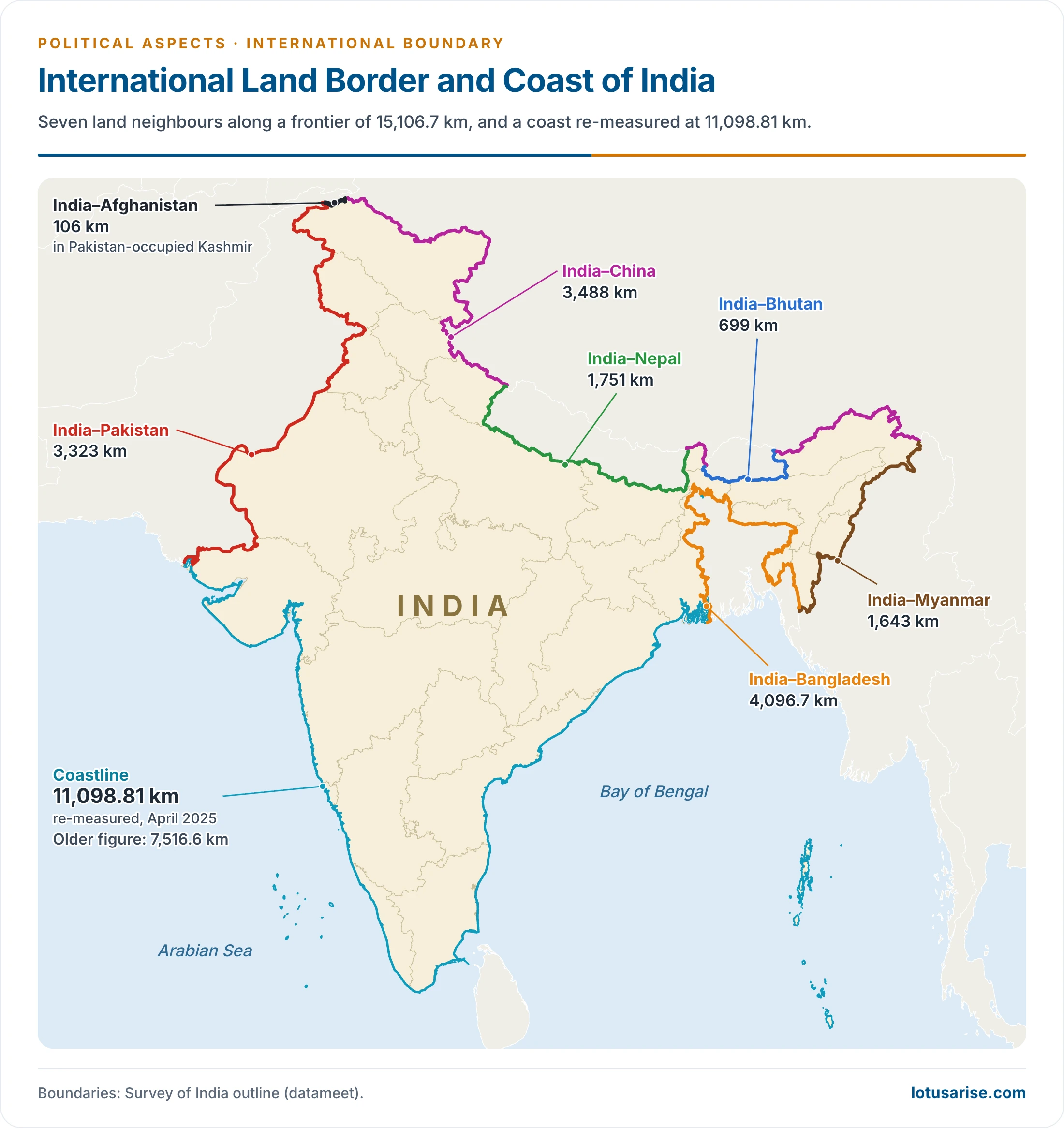
- Its land frontier is 15,106.7 km on the Ministry of Home Affairs count. The older round figure is about 15,200 km. The neighbours are Pakistan, Afghanistan, China, Nepal, Bhutan, Bangladesh and Myanmar.
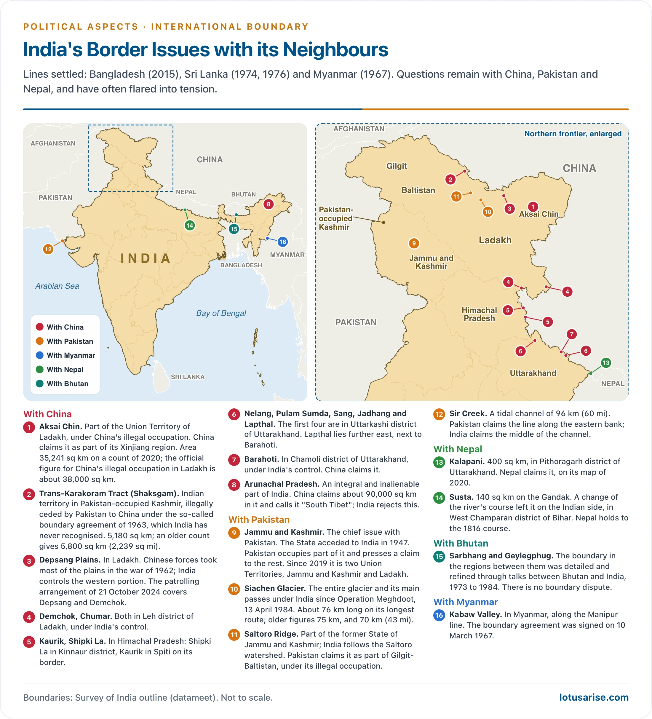
- Most of the problems with neighbours come from rival claims to territory, and those claims grow out of lines that were never clearly defined on the ground.
- India’s position: the whole of the Union Territories of Jammu and Kashmir and Ladakh, including Aksai Chin, and all of Arunachal Pradesh are Indian territory. The area held by Pakistan is Pakistan-occupied. The Line of Control (LoC) and the Line of Actual Control (LAC) are lines of control on the ground, not international boundaries.
- These lines mark out India’s extent and frontiers, and each can be read through the general laws of international boundaries and frontiers.
Land Frontiers at a Glance
International Boundary of India
| Neighbour | Direction | Ministry length (km) | Share | Older length (km) | Older share | Indian States and UTs along it |
|---|---|---|---|---|---|---|
| Bangladesh | East | 4,096.7 | 27.1% | 4,096 | 26.95% | West Bengal, Assam, Meghalaya, Tripura, Mizoram |
| China | North | 3,488 | 23.1% | 3,917 | 25.77% | Ladakh, Himachal Pradesh, Uttarakhand, Sikkim, Arunachal Pradesh |
| Pakistan | West, north-west | 3,323 | 22.0% | 3,310 | 21.78% | Gujarat, Rajasthan, Punjab, Jammu and Kashmir, Ladakh |
| Nepal | North | 1,751 | 11.6% | 1,752 | 11.53% | Uttarakhand, Uttar Pradesh, Bihar, West Bengal, Sikkim |
| Myanmar | East | 1,643 | 10.9% | 1,458 | 9.59% | Arunachal Pradesh, Nagaland, Manipur, Mizoram |
| Bhutan | North | 699 | 4.6% | 587 | 3.86% | Sikkim, West Bengal, Assam, Arunachal Pradesh |
| Afghanistan | North-west | 106 | 0.7% | 80 | 0.52% | Ladakh (Pakistan-occupied part) |
| Total | 15,106.7 | 100% | 15,200 | 100% |
- Longest and shortest: the Bangladesh line is the longest, the Afghanistan line the shortest. Both counts agree on this.
- Second-longest: the China line, which older counts put at over one-fourth of the land border and the Ministry’s count at about 23 per cent.
- What the figures include:
- Pakistan: the 3,323 km takes in the LoC. The International Border portion given by the Ministry in 2009 is 2,308 km: Rajasthan 1,037, Punjab 553, Gujarat 508 and Jammu 210.
- Bangladesh: West Bengal 2,216.7 km, Tripura 856, Meghalaya 443, Mizoram 318 and Assam 263.
- China: Ladakh 1,597 km, Arunachal Pradesh 1,126, Uttarakhand 345, Sikkim 220 and Himachal Pradesh 200. The Ministry’s 2017 note lists the first under Jammu and Kashmir, the State as it then stood.
- Afghanistan: this short line lies in the far north-west, in territory under Pakistan’s illegal occupation, so India has no direct land access to it. The two lines of the former Jammu and Kashmir, with China and with Afghanistan, give the area its strategic weight.
Land Boundaries, Neighbour by Neighbour
India–China Boundary
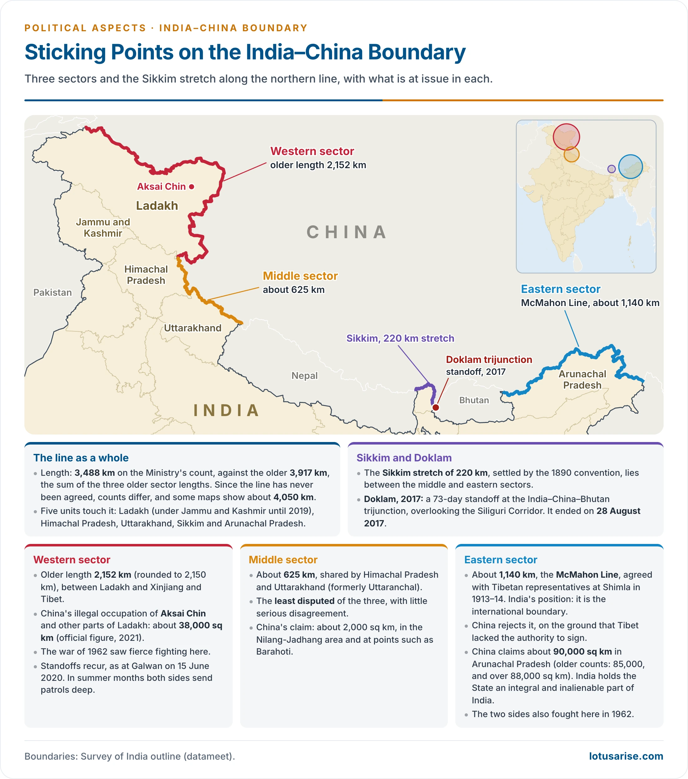
- Length: 3,488 km on the Ministry’s count, against the older 3,917 km. Since the line has never been agreed, counts differ, and some maps show about 4,050 km.
- Five units touch it: Ladakh (under Jammu and Kashmir until 2019), Himachal Pradesh, Uttarakhand (formerly Uttaranchal), Sikkim and Arunachal Pradesh.
- Origin: three strands made this line: Manchu policy, Chinese Republican policy and British policy.
- The terrain ruled out precise demarcation, so the line was only roughly set out on maps between British India and Tibet, then independent. China did not accept it in law, but did not press the matter while British rule lasted.
- Early goodwill: India became independent on 15 August 1947, and the Communist government took power in China on 1 October 1949. Relations began warmly.
- Panchsheel: the agreement on trade with the Tibet region, signed on 29 April 1954, set out five principles:
- Mutual respect for each other’s territorial integrity and sovereignty.
- Mutual non-aggression.
- Mutual non-interference in each other’s internal affairs.
- Equality and mutual benefit.
- Peaceful co-existence.
- It also named six passes for traders and pilgrims: Shipki La, Mana, Niti, Kungri-Bingri, Darma and Lipulekh.
- Panchsheel: the agreement on trade with the Tibet region, signed on 29 April 1954, set out five principles:
- Tibet: in the same year India recognised Chinese sovereignty over Tibet, which came under China’s direct control. Tibet stopped being a buffer, and the two powers faced each other along a “razor-thin” boundary.
- Three sectors are usually distinguished. The Sikkim stretch of 220 km, settled by the 1890 convention, lies between the middle and eastern sectors.
| Sector | Older length | Indian side | Chinese side | Position |
|---|---|---|---|---|
| Western | 2,152 km | Ladakh | Xinjiang (Sinkiang), Tibet | Aksai Chin under China’s illegal occupation |
| Middle | 625 km | Himachal Pradesh, Uttarakhand | Tibet | Least disputed |
| Eastern | 1,140 km | Arunachal Pradesh | Tibet | McMahon Line, rejected by China |
Western Sector
- Extent: this is the older 2,152 km between Ladakh and Xinjiang and Tibet. About 480 km of it runs between Xinjiang and Pakistan-occupied Kashmir, and the rest between Ladakh and Tibet.
- Alignment India upholds:
- In the north it runs along the Muztagh, Aghil and Karakoram ranges and across the Qara Tagh to the Kunlun.
- Further on it follows the divide between streams of the Indus basin and those of the Tarim, then passes the Lanak La towards the Kailash range.
- Here it separates India’s Indus system from China’s Khotan system.
- Treaty basis:
- The line is largely a product of British policy towards Jammu and Kashmir.
- Ladakh and Tibet fixed their frontier in the Treaty of Tingmosgang (1684), sometimes dated 1683.
- The Treaty of Chushul (1842), between the Dogra ruler of Jammu and Tibet, returned both sides to the old, established frontiers.
- Older accounts also list agreements of 1665 and 1686 in this chain.
- Precision: the line was never exactly drawn on maps, and that gap fed later disputes.
- China’s case rests on ethnic ties. It presents the barren Aksai Chin as a continuation of Tibet and Xinjiang in language, religion and culture.
- India’s case: Jammu and Kashmir has administered the area since 1849, and the old treaties confirm the Ladakh–Tibet boundary.
- What China claims:
- In north-east Ladakh: Aksai Chin, the Changmo valley, Pangong Tso and the Sponggar Tso area.
- A belt of about 5,000 sq km along all of eastern Ladakh.
- Part of the Hunza-Gilgit area in the north, which Pakistan illegally passed to it in 1963.
- Occupation:
- Chinese intrusions in this sector date from 1954. After renewed pressure in 1959 and the war of October 1962, the LAC became a series of positions held by Chinese forces, not a settled border.
- Official figure: China is in illegal occupation of about 38,000 sq km in Ladakh, stated by the Defence Minister in the Rajya Sabha in 2021. Older accounts give 37,555 sq km there and about 54,000 sq km of Indian territory in all.
- Pakistan illegally ceded a further 5,180 sq km of Indian territory in Pakistan-occupied Kashmir to China under the so-called boundary agreement of 1963. This is the Shaksgam tract.
- January 2026: after China restated its claim to Shaksgam, India repeated that the valley is Indian territory and that it has never recognised the 1963 agreement.
Middle Sector
- Extent: about 625 km, from the Ladakh end to the Nepal end of the crest, shared by Himachal Pradesh and Uttarakhand.
- Himachal stretch: the Spiti–Para Chu water parting comes first. The line then separates the Satluj feeders of the east from those of the west, and crosses the main river close to Shipki La.
- Uttarakhand stretch: the crest parts the Satluj from the Kali, Alaknanda and Bhagirathi, through the passes of Mana, Niti, Kungri-Bingri, Darma and Lipulekh, to the China–India–Nepal trijunction.
- Treaty basis: older accounts cite British–Tibetan arrangements of 1890 and 1919. The 1954 agreement’s list of passes is the firmer reference.
- China’s claim: about 2,000 sq km, in the Nilang-Jadhang area and at points such as Barahoti. There is little serious disagreement otherwise.
Eastern Sector
- Extent: about 1,140 km from the eastern end of Bhutan to the India–Tibet–Myanmar trijunction near Talu Pass.
- McMahon Line: it takes its name from Sir Henry McMahon, the Foreign Secretary of British India, who settled it with Tibet at the Shimla Convention of 1913–14. It crosses the Himalaya along the crest between Bhutan and Myanmar.
- India’s position: the McMahon Line is the international boundary. Tibet was competent to conclude treaties, and it did so.
- China’s claim: it calls the line illegal on the ground that Tibet lacked the authority to sign, and it claims land south of it down to the foot of the Himalaya in the Brahmaputra valley.
- It claims about 90,000 sq km in Arunachal Pradesh, the figure given to Parliament. Older accounts say over 88,000 sq km.
- China calls the State “South Tibet”. India has held that Arunachal Pradesh is an integral and inalienable part of India, and has rejected China’s lists of invented names, most recently in May 2025 and on 12 April 2026.
- India’s two main points:
- Britain from 1914 and India from 1947 exercised jurisdiction up to the line, and China raised no formal challenge until 1959.
- When Chinese maps showing these areas as China’s were raised in 1956, its government described them as cartographic errors to be looked into.
The 1962 War and After
- 1956: China’s road across Aksai Chin linked Tibet and Xinjiang and drew Indian alarm. China also moved into the then North-East Frontier Agency, now Arunachal Pradesh.
- October 1962: clashes from 1959 grew into a full war in Ladakh and the Agency. China later pulled back in the east, but kept most of Aksai Chin.
- Lessons usually drawn:
- The Himalaya alone was no sure defence.
- Trust in China’s friendship had weakened security planning in the borderlands.
- Quick Western supply of arms lifted the West’s image in India.
- Non-alignment could not replace military readiness.
- Mediation: the Colombo Powers, led by Ceylon, tried and failed to broker a settlement.
- Agreements: Peace and Tranquillity along the LAC (7 September 1993); confidence-building measures in the military field (29 November 1996); Political Parameters and Guiding Principles (April 2005).
- Sikkim: China dropped Sikkim from its list of countries on its official website in the early 2000s.
- Package or sectors: China floated a package deal, Aksai Chin to China and the McMahon Line to India. India has preferred to go sector by sector.
- 2020 to 2024: the Galwan clash of 15 June 2020 led to a long standoff in eastern Ladakh. The patrolling arrangement of 21 October 2024 at Depsang and Demchok brought disengagement there.
- 24th round of Special Representatives’ talks (19 August 2025, New Delhi): an Expert Group on boundary delimitation was agreed for an “early harvest”, and border trade through Lipulekh, Shipki La and Nathu La was to reopen.
- 25th round (25 August 2026, Beijing): the Ministry of External Affairs said both sides would first settle the group’s terms of reference, towards an “early and substantial harvest”. New military hotlines in the eastern and middle sectors and two new meeting points for senior commanders were also agreed.
- The sectors that such a harvest would cover have not been announced.
- China’s strategic moves: the Medog dam project on the Yarlung Tsangpo, begun on 19 July 2025, adds to India’s international water disputes. Rail links across Tibet, the Karakoram Highway through Pakistan-occupied Kashmir, and ports around the Indian Ocean add to the pressure. India objects to any project crossing Indian territory.
India–Pakistan Boundary
- Origin: before 1947 both were part of British India. Partition on the basis of religious majorities gave rise to two states, and the line was drawn under Sir Cyril Radcliffe, chairman of the Boundary Commissions.
- The transition saw terrible violence on both sides, and mutual hostility has marked relations since.
- Course: it starts in the Great Rann of Kachchh in Gujarat, crosses the Rajasthan desert and the fertile Punjab plains, enters the hills of Jammu and Kashmir, and ends in the Karakoram.
- Character: a superimposed line with no natural basis. In Punjab it cuts across canals, railways, roads, fields, villages and shrines.
- Sections beyond the International Border: the LoC runs about 740 km to the point NJ9842, and the Actual Ground Position Line about 110 km beyond it along the Saltoro Ridge. Older accounts give 788 km and 150 km.
- Main disputes: the older pair is the Rann of Kachchh and Jammu and Kashmir, to which Siachen and Sir Creek are added.
Rann of Kachchh Dispute
- Pakistan’s case: the Radcliffe line was poorly set here. The Rann was a landlocked sea, to be shared equally. It claimed about 9,065 sq km.
- India’s case: the Rann is a marsh that always belonged to Kachchh State, which merged with India after independence.
- Settlement: after fighting in 1965, a tribunal chaired by Gunnar Lagergren was set up under the agreement of 30 June 1965. Its award of 19 February 1968 gave Pakistan about 906.5 sq km, a tenth of the claim. Demarcation ended in 1969.
Jammu and Kashmir
- The issue: the State acceded to India in 1947. Pakistan occupies part of it and presses a claim to the rest. This has been the chief obstacle to normal relations.
- Extent: the former State covered about 2,22,236 sq km and bordered China and Afghanistan. Of this, Pakistan is in illegal occupation of about 78,000 sq km (78,114 sq km in fuller counts).
- Six regions made up the State:
| Region | Location | Character |
|---|---|---|
| Kashmir Valley | Centre | Muslim majority, with a Kashmiri Pandit minority long prominent in state service; the seat of government |
| Jammu | South | Hindu majority; about one-seventh of the area; home of the former Dogra rulers |
| Ladakh (“Little Tibet”) | East | High, barren plateau; about one-third of the area. Census 2011: Leh district 66.4% Buddhist, Kargil district 76.9% Muslim |
| Gilgit | North | High mountains, almost wholly Muslim; under Pakistan’s illegal occupation |
| Baltistan | Far north, along the Indus | High mountains, mainly Muslim; under Pakistan’s illegal occupation |
| Punch | North of Jammu, west of the Valley | Mainly Muslim, close to Pakistan and partly under its illegal occupation; drained towards the Jhelum |
- Pakistan’s claim rests on the State’s Muslim majority, its road links, and the rivers Ravi, Chenab, Jhelum and Indus that flow on into Pakistan and feed its farming.
- India’s answer: accession gave India sovereignty over the State, and handing it over on grounds of religion would deny the secular basis of the Indian state. India also stresses the illegality of Pakistan’s support for the raiders and for the so-called “Azad Kashmir” administration.
- Strategic weight: China’s move into Tibet, the road through Aksai Chin and the war of 1962 made the State’s position more urgent for India. Its nearness to Pakistan, China, Afghanistan and Tajikistan adds to this.
History of the Dispute
- Before accession: Jammu and Kashmir was ruled by Maharaja Hari Singh, who wanted to stay out of both dominions.
- 22 October 1947: armed tribesmen backed by Pakistan invaded, looting and burning villages.
- 26 October 1947: the Maharaja sought India’s help and signed the Instrument of Accession. It was accepted on 27 October, and the State became legally part of India. Pakistan has never accepted this, and the war of 1947–48 followed.
- January 1948: Prime Minister Jawaharlal Nehru took the matter to the United Nations.
- Ceasefire: with United Nations and British efforts, fighting stopped on 1 January 1949. Pakistan was left holding about a third of the State.
- Plebiscite: the commission proposed one, on condition that Pakistan first withdrew its forces. That never happened, and no plebiscite was held.
- Constitutional steps:
- The State had special status under Article 370. Its Constituent Assembly confirmed its place within India, which older accounts date to 1956.
- Article 370 ceased to apply in August 2019, the State was reorganised into two Union Territories on 31 October 2019, and the Supreme Court upheld the change on 11 December 2023.
- Wars:
- 1947–48: over the State itself.
- 1965: Pakistan’s second attempt.
- 1971: ended with the surrender of Pakistan’s forces in the east and the birth of Bangladesh.
- 1999 (Kargil): Pakistani troops occupied heights in the sector and were driven out.
- Sponsorship of terrorism: failure in open war was followed by a proxy war through terrorists sent across the line, the pattern of cross-border terrorism to which the Pahalgam attack of April 2025 belongs.
- After Pahalgam, India held the Indus Waters Treaty in abeyance, closed Attari–Wagah and carried out Operation Sindoor. An understanding to stop military action was reached on 10 May 2025.
- Religion and politics in the argument:
- Pakistan presents the State as a Muslim-majority area ruled by a Hindu Maharaja, about 77 per cent Muslim before Partition, and treats this as the root of its claim.
- India rejects religion as a basis for territory.
- India dates the conflict to Pakistan’s attack of October 1947, and its troops arrived only after accession, to defend the people of the State.
Siachen Glacier
- Location and size: in the eastern Karakoram, with a length of about 76 km and a width of 2 to 8 km, falling from about 5,753 m at Indira Col to about 3,620 m at its snout. Older accounts give 75 km and describe the whole area as above 5,800 m.
- Why it matters: it lies north-east of Pakistan-occupied Kashmir and not far from the Karakoram Highway, which serves China and Pakistan as an economic and military link.
- Origin of the dispute: the line stops at NJ9842. The 1949 Karachi Agreement carried it “thence north to the glaciers”, with no further detail. Pakistan extends it north-east to the Karakoram Pass, while India follows the Saltoro watershed.
- Position today:
- Operation Meghdoot (13 April 1984) placed the entire glacier and its main passes (Sia La, Bilafond La, Gyong La) under India. Older accounts say India held only the south-eastern part.
- Indian troops reach it through the Nubra valley. It is the world’s highest battlefield, and both sides keep forces on alert.
- It heads the list of India’s glaciers for length.
Sir Creek
- What it is: a tidal channel of about 96 km between Gujarat and Sindh, at the end of the Rann of Kachchh. Fishing, oil prospects and the sea boundary that depends on it give it value.
- The rival lines: India claims the middle of the channel, under the thalweg principle. Pakistan claims the eastern bank. Both read differently the Bombay Government Resolution of 1914.
- Position: the boundary in the area and the maritime boundary beyond it remain undemarcated.
- Recent: on 2 October 2025 the Defence Minister warned at Bhuj that any misadventure in this sector would meet a decisive response, citing Pakistan’s military build-up near the creek.
Links Opened and Closed
- Confidence-building steps: India took many initiatives to ease relations:
- Bus links: Srinagar–Muzaffarabad and Amritsar–Lahore.
- Rail link: Munabao–Khokrapar.
- Pilgrim visits in both directions, meeting points for divided families, and trade across the LoC.
- Reversal:
- India suspended LoC trade in April 2019, citing misuse of the routes for weapons, narcotics and fake currency.
- The Kartarpur corridor services were suspended in May 2025.
- Ceasefire violations on the line have recurred through these years.
India–Bangladesh Boundary
- Length: 4,096.7 km, the longest of India’s land lines. Older accounts round it to 4,096 km.
- Origin: the Radcliffe Award split Bengal into East Pakistan, now Bangladesh, and the Indian State of West Bengal. It became Bangladesh’s border in 1971.
- Character: it runs through plains, river belts, hills and jungle with hardly any natural obstacle, across a densely settled delta farmed right up to the line. Shifting rivers keep altering it.
- Early overlapping claims:
- Rajshahi (Bangladesh) and Murshidabad (India): the Ganga’s channel kept changing, and the boundary with it.
- Daulatpur (Bangladesh) and Karimpur (India): the line in the Mathabhanga was set midstream, and Bangladesh gained about 13 sq km.
- Sylhet (Bangladesh) and the Garo, Khasi and Jaintia Hills (India): dense forest made demarcation hard. The Radcliffe line stood.
- Barisal (Bangladesh) and Gobindpur (India).
Exchange of Enclaves
- An enclave is a piece of one state’s territory wholly surrounded by another’s. Residents here lacked full legal rights in either country, with poor electricity, schools, health care and water.
- Origin: the enclaves are traced to a treaty of 1713 between the Mughal Empire and local rulers.
- Treaties:
- 1974 Land Boundary Agreement, implemented except for three issues: about 6.1 km of undemarcated line, the enclaves and adverse possessions.
- Protocol of 6 September 2011, which settled all three.
- 100th Constitutional Amendment (May 2015), which Parliament passed to give effect to them.
- Instruments of ratification exchanged at Dhaka on 6 June 2015.
- Exchange at midnight on 31 July 2015:
- 111 Indian enclaves (17,160.63 acres) in Bangladesh went to Bangladesh.
- 51 Bangladeshi enclaves (7,110.02 acres) in India came to India.
- Undemarcated stretches: Daikhata-56 (West Bengal), Muhuri River–Belonia (Tripura) and Lathitila–Dumabari (Assam).
- Adverse possessions stayed with their holders: India received 2,777.038 acres and transferred 2,267.682 acres.
- Residents chose their nationality. The joint headcount of 2011 gave 51,549 people:
- 14,215 in Bangladeshi enclaves, who became Indian citizens.
- 37,334 in Indian enclaves. Of these, 979 opted for India in the joint survey and the remaining 36,355 became Bangladeshi citizens. Later counts differ slightly.
- Those moving did so by 30 November 2015.
- Result: both groups gained a nationality and access to services.
- Tin Bigha: the corridor leased so that Bangladesh can reach its Dahagram–Angarpota enclave has been open for 24 hours since 2011.
Current Issues
- Fencing:
- Lok Sabha, 4 February 2025: 3,232.218 km fenced and 864.482 km left, including 174.514 km not feasible.
- West Bengal, August 2025: 1,647.696 km fenced of 2,216.7 km.
- Land: the Calcutta High Court in January 2026 ordered land to be handed over by 31 March. The State cabinet approved the transfer on 11 May 2026, and handovers followed.
- Since August 2024: relations have changed with the fall of the Sheikh Hasina government and the interim administration that followed.
- January 2025: India called in Bangladesh’s Acting High Commissioner after Dhaka objected to fencing, saying the work followed agreements between the two border forces.
- June 2026: the first talks of the Director Generals of the two border forces under the new Bangladesh Nationalist Party government took place in New Delhi from 8 to 11 June. They agreed on better intelligence sharing and coordinated patrols. Border deaths and alleged push-ins stayed unresolved.
- Migration: illegal migration into Assam, Tripura and West Bengal remains a main concern for India. Fencing within 150 yards of the line is a recurring objection from Bangladesh.
- Water: Farakka Barrage, built to flush the Hugli and protect Kolkata port, led to the Ganga Water Treaty of 1996, which expires on 12 December 2026. Teesta sharing is unsettled, along with the Feni, Manu, Muhuri, Khowai, Gumti, Dharla and Dudhkumar, among the river water disputes with neighbours.
- Transit: the Siliguri Corridor (Chicken’s Neck) is the North-East’s only land link with the rest of India, which raises the value of transit through Bangladesh and of the Kaladan route through Myanmar.
India–Nepal Boundary
- Length and course: 1,751 km (older 1,752 km), running east–west largely along the foothills of the Shiwalik Range, and touching Uttarakhand, Uttar Pradesh, Bihar, West Bengal and Sikkim.
- History:
- Treaty of Sugauli (1815–16): after the Anglo-Nepalese War, the British took the hill tracts of Nainital, Almora, Garhwal, Dehra Dun and Shimla. Nepal’s eastern gains went back to Sikkim under the Treaty of Titalia (10 February 1817).
- Treaty of 1 November 1860: Britain returned the western Terai, the Naya Muluk, for Nepal’s help in 1857. The present line dates from this. Older accounts give 1858.
- Character: an open border, with free movement of people and goods. Nepal is landlocked between India and China and balances between the two.
- Disputes: the border is generally calm, but two points remain open.
- Kalapani–Lipulekh–Limpiyadhura:
- Kalapani is part of Pithoragarh district, Uttarakhand. India’s map of 2 November 2019 shows it as Indian territory.
- Nepal issued a new map in May–June 2020 claiming the area, and amended its Constitution. The dispute turns on the source of the Kali named in the Sugauli treaty.
- 3 May 2026: when Nepal objected to the Kailash Mansarovar Yatra through Lipulekh, India said trade through the pass has run since 1954, and called the claim a “unilateral artificial enlargement” that is “untenable”. It stayed open to talks on boundary issues.
- Susta: on the Gandak (Narayani), where a change of the river’s course left the area on the Indian side, in West Champaran district, Bihar. Nepal holds to the 1816 course.
- Kalapani–Lipulekh–Limpiyadhura:
India–Bhutan Boundary
- Length: 699 km (older 587 km), along Sikkim, West Bengal, Assam and Arunachal Pradesh. It is peaceful, with no boundary dispute between the two.
- History:
- Contact and conflict with the British began in the 1770s, and a first treaty is dated 1774.
- Treaty of Sinchula (11 November 1865): it followed the Duar War. Bhutan gave up the Duars for an annual subsidy of Rs 50,000.
- Treaty of Punakha (8 January 1910): raised the subsidy to Rs 1 lakh.
- Treaty of Friendship (8 August 1949): independent India took this relationship forward. India took on a guiding role in foreign affairs, and military tension faded.
- 2007 revision: removed that clause, and the two now cooperate on shared national interests.
- Bhutan’s standing: a buffer between India and China, a United Nations member since 1971, and a democracy since 2008.
- Cooperation: political, economic and cultural links are close, above all in hydroelectricity.
- China and Bhutan: China rejects the watershed along Bhutan’s north and presses claims of nearly 775 sq km in older accounts. India protested these in 1959.
- Doklam, 2017: a 73-day standoff at the India–China–Bhutan trijunction, overlooking the Siliguri Corridor. It ended on 28 August 2017.
- Sakteng, 2020: China newly claimed this sanctuary at a Global Environment Facility meeting.
India–Myanmar Boundary
- Length and course: 1,643 km (older 1,458 km), from the India–China–Myanmar trijunction to the southern tip of Mizoram, along the divide between the Brahmaputra and the Ayeyarwady. It passes Arunachal Pradesh, Nagaland, Manipur and Mizoram, through thickly forested hills.
- Treaty: the Treaty of Yandabo (1826) opened the way, and the boundary agreement was signed on 10 March 1967.
- Trijunction:
- China’s 1960 treaty with Burma ended at Diphu Pass.
- India places the trijunction about five miles further north, near Talu Pass.
- Burma later left this to India and China, so the point is now part of the India–China dispute.
- Current issues:
- Illegal flows: smuggling of arms and drugs from the Golden Triangle, and the movement of insurgent groups, affect this border.
- Free Movement Regime: border tribes could move 16 km either side without a visa. India announced its end in February 2024 and from December 2024 limited movement to 10 km with border passes.
- Fencing: the whole 1,643 km is to be fenced, on a project of about Rs 31,000 crore approved in 2024. Naga and Kuki-Zo bodies object to it.
- Instability: conflict in Myanmar since the coup of 1 February 2021 has unsettled this frontier.
- Shared concerns: socio-economic development, insurgency, regional peace and the protection of sovereignty.
- Connectivity: ongoing projects are the Kaladan Multi-Modal Project, the Trilateral Highway and the Moreh–Tamu crossing.
Maritime Boundaries
- Limits: India claims a territorial sea of 12 nautical miles and an exclusive economic zone of 200 nautical miles under the Act of 1976. Its coastline was re-measured at 11,098.81 km in April 2025, against the older 7,516.6 km.
- Seven maritime neighbours:
| Neighbour | Position |
|---|---|
| Sri Lanka | Agreed, 1974 and 1976 |
| Maldives | Agreed, 1976 |
| Indonesia | Agreed, 1974 and 1977 |
| Thailand | Agreed, 1978 and 1993 |
| Myanmar | Agreed, 1986 |
| Bangladesh | Settled by arbitral award, 7 July 2014 |
| Pakistan | Open, because of Sir Creek |
India–Sri Lanka Boundary
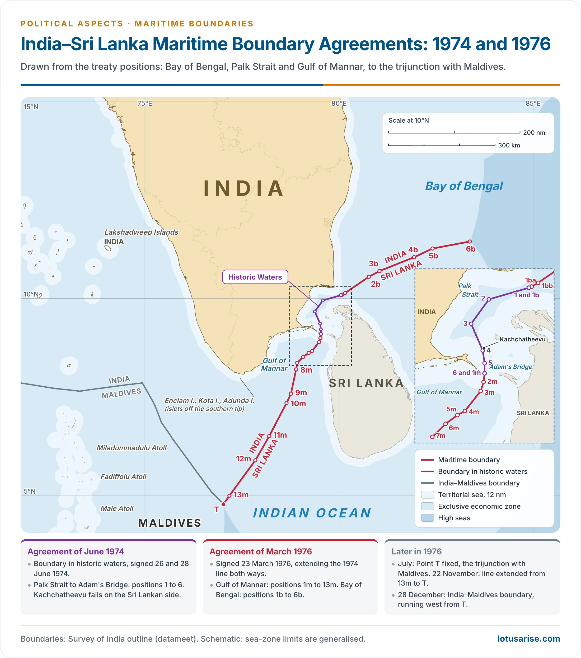
- A sea boundary only: a shallow sea separates the two, with about 32 km from Dhanushkodi to Talaimannar, across Adam’s Bridge.
- Kachchatheevu: a small island in the Palk Strait.
- 1974: it fell on the Sri Lankan side under the agreement on the boundary in historic waters.
- 1976: a further agreement closed fishing by either side in the other’s waters, the root of today’s fishermen issue.
- Tamil Nadu: its Assembly passed a resolution seeking retrieval in April 2025.
- Supreme Court, 6 October 2026: in petitions pending since 2008, the Attorney General said the Centre does not wish to reopen the treaties. The matter is listed for February 2027.
- People of Indian origin:
- The two countries have long been close, and a large number of Tamils of Indian origin live in Sri Lanka. Their status became a major bilateral question.
- Prime Minister Lal Bahadur Shastri and Sirimavo Bandaranaike settled much of it in the pact of 1964, followed by the pact of 28 June 1974.
- Later strain: the anti-Tamil violence of July 1983 sent about 1.2 lakh refugees to Tamil Nadu and strained ties. The insurgency of the LTTE made this sea line active.
- Improvement: the Indo-Sri Lanka Accord of 29 July 1987 eased relations.
What the Boundaries Share
- Colonial origin: nearly all these lines were fixed in the last two centuries, across a realm with long shared history. People and cultures straddle them, so a line divides what was once joined.
- Terrain and rivers: high ranges kept lines undemarcated in the north, while moving rivers unsettle them in the Gandak, the Ganga and the Kachchh creeks.
- Settled cases: the Rann award (1968), Myanmar (1967), Sri Lanka (1974, 1976) and Bangladesh (2015) show that talks and arbitration can close such disputes. Conflict over the rest has imposed heavy human and economic costs on all sides.
Previous Year Questions
2026With reference to the international boundary between India and Bangladesh, discuss the related issues and challenges.2025With reference to international boundaries of India, discuss the related issues, giving suitable examples.2023Map item: Moreh2022The Kalapani dispute has opened a new front on the India-Nepal international border. Explain.2021Map item: Sir Creek2018Is the land boundary of India with its neighbouring countries a cultural divide or divided culture? Explain with suitable examples.2017Bring out the geopolitical implications of the Doklam dispute in the context of Indo-China relations.2016Explain the origin, dimension and implications of the Sino-Indian border dispute.2014India is involved in a number of border disputes. Explain the reasons and remedies.2012Examine the origin, dimensions and implications of the Sino-Indian border dispute.2004Write an essay on the origin, dimensions and implications of Sino-Indian border dispute.2001Discuss the geopolitical importance of India’s Land Boundaries.1992Write short note: Major issues involved in the Sino-Indian boundary conflict.1991Discuss the political issues involved in the ‘Tin Bigha’ or Siachen dispute.1990Write short note: The international boundary of India and related issues.1988Write short note: The Sino-Indian Boundary.





✌️