

- India’s coastline was long given as 7,516.6 km, and it was re-assessed in 2025 to 11,098.81 km. It passes through 13 States and Union Territories in total.
- South India’s peninsular form splits the coast in two, and Kanniyakumari is the point of division.
Length of the Coastline
Old and New Figures
- Old figure: 7,516.6 km, in use since the 1970s.
- It is often split as 6,100 km of mainland coast plus 1,197 km of island coast. Those two parts total 7,297 km and do not match it.
- The State-wise table of that period gives 5,422.6 km for the mainland and 2,094 km for the islands, and this does add up to 7,516.6 km.
- New figure: 11,098.81 km, worked out by the National Hydrographic Office with the Survey of India, and accepted with the concurrence of all coastal States and UTs.
- It was promulgated by the Ministry of Ports, Shipping and Waterways on 29 April 2025.
- Why the jump: the coast did not grow. The method changed.
- The old figure probably came from maps of 1:4,500,000 or smaller, and the new one uses 1:2,50,000 data with modern GIS software.
- A larger scale catches more bays, inlets and small irregularities. This is the coastline paradox: a measured length depends on the scale of the map.
- The new figure is measured at the High-Water Line. River mouths, creeks and estuaries are closed at suitable points, and the coasts of offshore islands are counted.
- It will be reviewed every 10 years.
- India’s offshore land is now put at 1,298 islands and islets (1,059 islands and 239 islets).
- The revision does not change Coastal Regulation Zone limits, which follow the demarcated High Tide Line.
Course of the Coast
- Western coast: it begins at the Gulf of Kutch in the westernmost corner and crosses the Gulf of Khambhat.
- It then runs through Salsette Island of Mumbai along the Konkan, south across the Raigad district region, through Kanara and on to Mangalore.
- It continues along the Malabar coast to Cape Comorin, the southern tip of India, where the coast faces the Indian Ocean.
- South-eastern coast: from there it runs along the Coromandel Coast, or Cholamandalam.
- Along the Bay of Bengal it then passes through the Utkala Kalinga region to the easternmost corner of the shoreline, near the Sundarbans in coastal East India.
- It crosses nine States and four Union Territories. The Arabian Sea and the Indian Ocean lie on the west, and the Bay of Bengal on the east.
- Coastal States: Keralam (Kerala), Tamil Nadu, Gujarat, West Bengal, Goa, Karnataka, Maharashtra, Andhra Pradesh and Odisha.
- Coastal Union Territories: Daman & Diu, Puducherry, Lakshadweep Islands and Andaman & Nicobar Islands.
- Daman & Diu was merged with Dadra & Nagar Haveli in 2020 into a single Union Territory, and the coastal length is still listed under the old name.
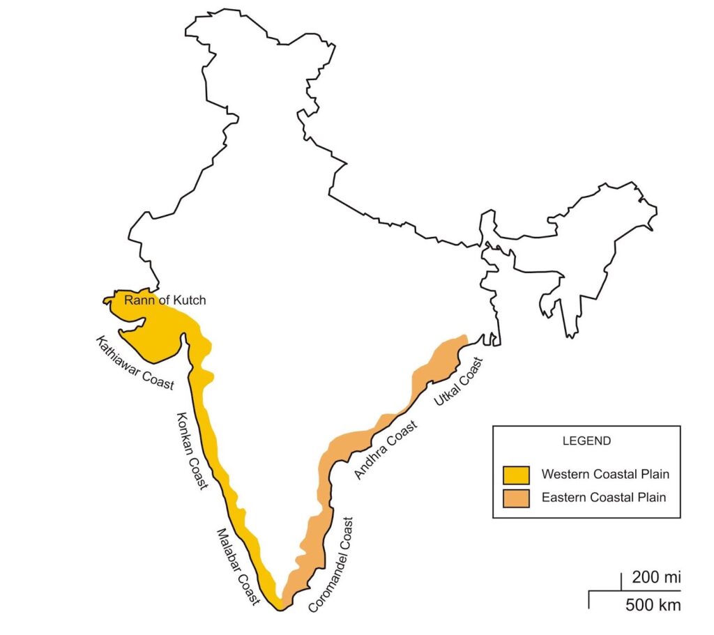
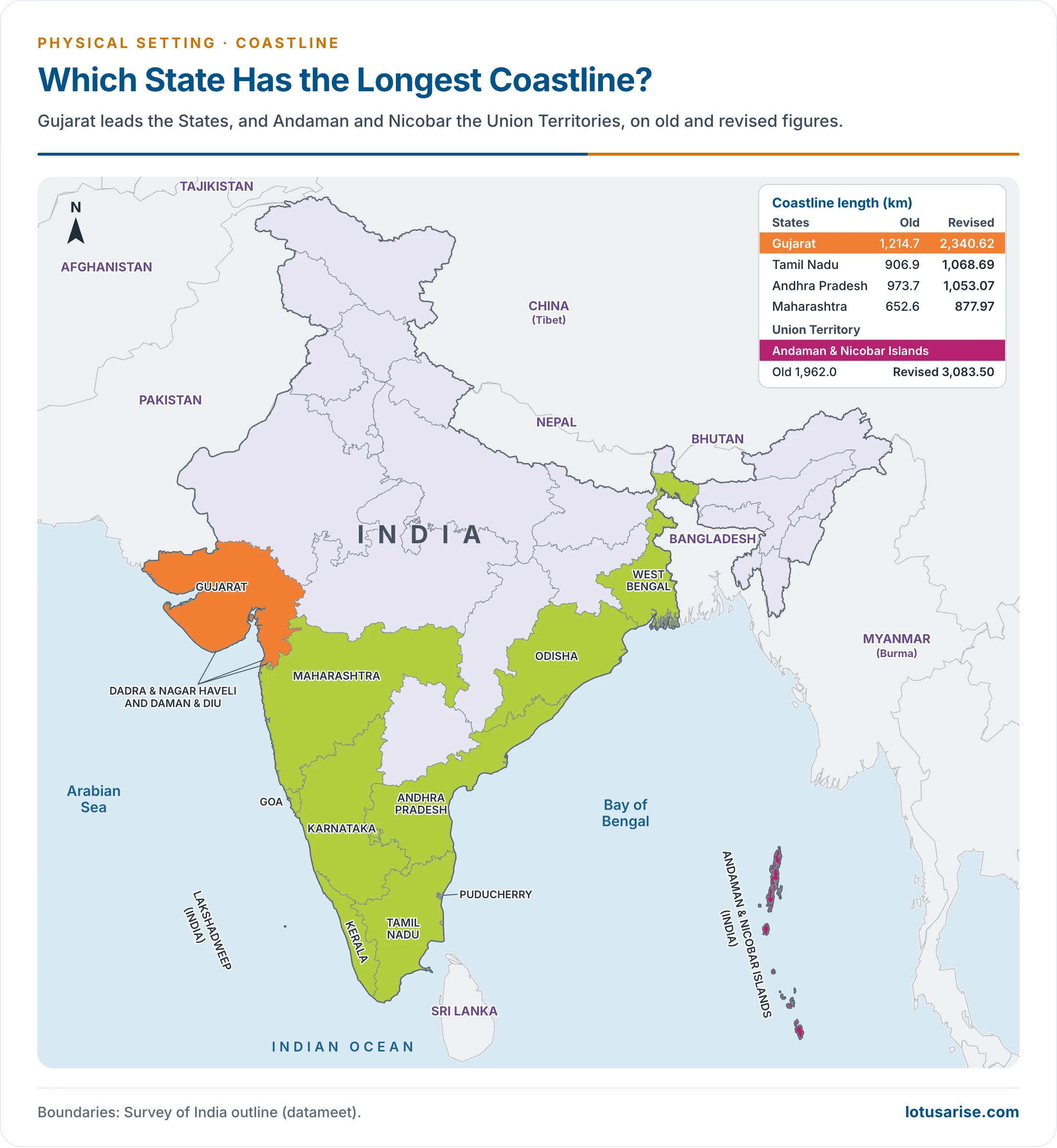
- Gujarat has the longest coastline among States, and Andaman & Nicobar Islands the longest among UTs. Both rankings hold under the old and new figures.
- By location and active geomorphic processes, the mainland coast falls into two groups:
State-wise Length of Coastline of India
| State/UT | Old length (km) | Revised length (km) |
|---|---|---|
| Gujarat | 1,214.7 | 2,340.62 |
| Tamil Nadu | 906.9 | 1,068.69 |
| Andhra Pradesh | 973.7 | 1,053.07 |
| Maharashtra | 652.6 | 877.97 |
| West Bengal | 157.5 | 721.02 |
| Keralam | 569.7 | 600.15 |
| Odisha | 476.4 | 574.71 |
| Karnataka | 280.0 | 343.30 |
| Goa | 160.5 (with Daman & Diu) | 193.95 |
| Daman & Diu | counted with Goa | 54.38 |
| Puducherry | 30.6 | 42.65 |
| Lakshadweep Islands | 132.0 | 144.80 |
| Andaman & Nicobar Islands | 1,962.0 | 3,083.50 |
| Total coastline of India | 7,516.6 | 11,098.81 |
- What changed in rank: Tamil Nadu moved to second place and Andhra Pradesh to third, and West Bengal grew most sharply in proportion, from 157.5 km to 721.02 km, because its delta creeks and islands now count at the finer scale.
- By addition, the revised table gives about 7,870.51 km for the mainland and 3,228.30 km for the two island groups.
Evolution of the Coastline
- Gondwana breakup: the coast is generally straight and regular, with few creeks, inlets, backwaters and promontories. Eduard Suess traced this to disruption and faulting of Gondwanaland in the Cretaceous.
- This regularity leaves few good natural harbours.
- The Arabian Sea and the Bay of Bengal took shape during the Cretaceous or early Tertiary, after Gondwanaland broke up.
- Timing, as now read:
- East coast: rifting between India and Antarctica from about 120 million years ago.
- West coast: separation from Madagascar about 88 million years ago, then from the Seychelles about 62–65 million years ago, after the Deccan eruptions.
- Both are now passive margins, the Western Ghats being the scarp behind the western one.
- East coast character: from the Ganga delta to Kanniyakumari, marked by the deltas of the Mahanadi, Godavari, Krishna and Cauvery, and by lagoons, of which Chilka and Pulicat stand out.
- West coast character: almost straight, north to south, from the Gujarat plains to Kanniyakumari, with many coves and creeks and a few estuaries, notably the Narmada and Tapi.
- Malabar carries lakes, backwaters and lagoons, with Vembanad the biggest.
Coastlines of Emergence and Submergence
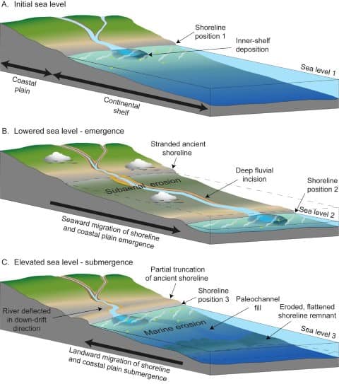
- A coastline of emergence forms through uplift of the land or lowering of the sea. A coastline of submergence is the exact opposite case.
- Bars, spits, lagoons, salt marshes, beaches, sea cliffs and arches are given as typical features of emergence. Spits, lagoons and beaches also form on stable coasts, so these landforms need dating or raised levels before they prove emergence.
- East coast: especially its south-eastern part (Tamil Nadu), appears to be a coast of emergence.
- Coromandel coast (Tamil Nadu): coastline of emergence.
- West coast: both emergent and submergent.
- The northern portion is submerged as a result of faulting, and the southern portion, the Keralam coast, is an emergent coast.
- Malabar coast (Keralam): coastline of emergence.
- Konkan coast (Maharashtra and Goa): coastline of submergence.
- The western margin also shows a northerly tilt: its youngest submarine terraces lie deeper in the north than in the south.
- The northern portion is submerged as a result of faulting, and the southern portion, the Keralam coast, is an emergent coast.
- Sea-level history: the world’s sea level has moved too.
- In the glacial periods it stood about 100 m lower, then rose after the last glaciation.
- Records around the Peninsula show a mid-Holocene high stand from about 6,000 to 3,000 years ago, up to about 5 m above the present level in places.
- Relative sea-level records add complexity: Gujarat, Maharashtra, Tamil Nadu and Bengal show an uplift component in the Holocene, and Andhra Pradesh shows subsidence. The simple labels above are broad summaries.
Evidence of Submergence
- Mumbai: tree stumps, still rooted in old soil, lie 6–12 m below present sea level on the island’s eastern side, the remains of a drowned forest.
- Earlier writers read this as local subsidence, and later work favours world-wide sea-level change, because the forests are far older than the raised beaches.
- Tinnevelli (Tirunelveli) coast: another drowned forest, an old land surface of about half an acre.
- Puducherry: a thick lignite bed 73 m below ground points to sinking.
- Ganga delta: similar vegetable debris at depth.
- Makran coast: a sudden increase in depth some 30 km offshore is read as a drowned cliff. This lies outside India, on the Arabian Sea.
- Dwarka: marine archaeologists found remains under shallow water off the Saurashtra coast, including walls, a jetty and stone anchors, implying a sea-level rise of about 5 m since about 1400 BCE in that zone.
- Poompuhar and Tranquebar (Tamil Nadu): submerged structures, with shoreline retreat of about 497 m and 380 m in 75 years.
- Lakshadweep: the coral islands probably mark a submerged land.
- Andaman and Nicobar: once joined with the Arakan Yoma, they became islands as lower ground around them sank.
- Adam’s Bridge (Ram Setu): once linked India and Sri Lanka, and was drowned in Quaternary times.
- It survives as a chain of shoals about 29 km long between Dhanushkodi on Pamban Island and Talaimannar on Mannar Island. About 99.98% of it now lies under water.
Evidence of Emergence
- West coast: raised beaches at 30–45 m in many places, and marine shells on land far above tide level.
- Sahyadri: the steep face parallel to the coast was once read as a sign of recent elevation from the sea. It is now seen mainly as a rift-flank scarp.
- Keralam: the proofs are many. Coral reefs lie under alluvium several kilometres inland, and the lakes, lagoons, backwaters and spits point the same way. Two or more phases of uplift are recognised.
- Rann of Kachchh: coastal dunes, sea cliffs on islands of the Gulf, sea caves inland and raised beaches on the margins, with a total fall of about 26 m.
- In historic times the Rann was a gulf, silted up by rivers and raised slowly. Mid-Holocene records treat it as navigable until about 2,000 years ago.
- The Luni once reached the sea across the Great Rann by the Kori estuary, and the Western Banas crossed the Little Rann to the Gulf of Kachchh.
- Andhra coast: the delta’s advance has left Kolleru Lake, once a shore lagoon, far inland.
Both at Once: Earthquakes
- Rann of Kachchh, 16 June 1819: one of the great earthquakes of India, about magnitude 7.7.
- About 5,180 sq km on the western border sank by 3.6–4.5 m. The fort of Sindri was drowned except for one turret.
- About 1,550 sq km rose by several metres, the raised ridge being the Allah Bund, “the dam of God”, about 80 km long.
- Andaman and Nicobar, 26 December 2004: the great Sumatra-Andaman earthquake raised some coasts and sank others within minutes.
- North and Middle Andaman’s western coasts rose by more than 1 m.
- Islands south of about 10°N sank 1–1.5 m, and Indira Point sank about 4.25 m, leaving its lighthouse base in water.
Islands that Come and Go
- Near the Ganga delta, islands appear and vanish with sea level and sedimentation.
- New Moore Island (South Talpatti) is the classic case. It emerged in recent decades and was claimed by both India and Bangladesh.
- It was reported fully underwater by 2010, and later remote-sensing work documented its disappearance.
- Ghoramara and Sagar islands are losing land too.
Present Shoreline Change
- The National Centre for Coastal Research analysed 6,632 km of mainland coast from 1990 to 2018.
- About 33.6% is eroding, 26.9% accreting and 39.6% stable.
Significance of Indian Coastlines
- The coastlines, including the Andaman and Nicobar and Lakshadweep groups, were long given as 7,516.6 km and are now given as 11,098.81 km.
- The long coast gives its areas a favourable climate with no extreme temperature, ideal for human development.
- Major significance of the coastal plains:
- Fertile soils suit cultivation, and rice is the major crop.
- Big and small ports carry trade, about 95% of India’s trade by volume and 70% by value.
- The sedimentary rocks are said to hold large deposits of mineral oil, a source for the marine economy.
- Fishing is an important occupation.
- Mangroves, coral reefs, estuaries and lagoons make rich coastal and marine ecosystems, with great tourism potential.
- The revised length also supports better planning for ports, tourism zones, cyclones, erosion and flooding, and it improves the management of territorial waters and the EEZ.
Previous Year Questions
2009Distinguish between the West and East coasts of India in terms of their evolution, present topography and drainage pattern.





Helpful 👍❤️