

- A coastal plain is flat, low-lying land next to a sea coast. A fall line, where rivers drop off harder upland rock, commonly marks the border between such a plain and the piedmont behind it.
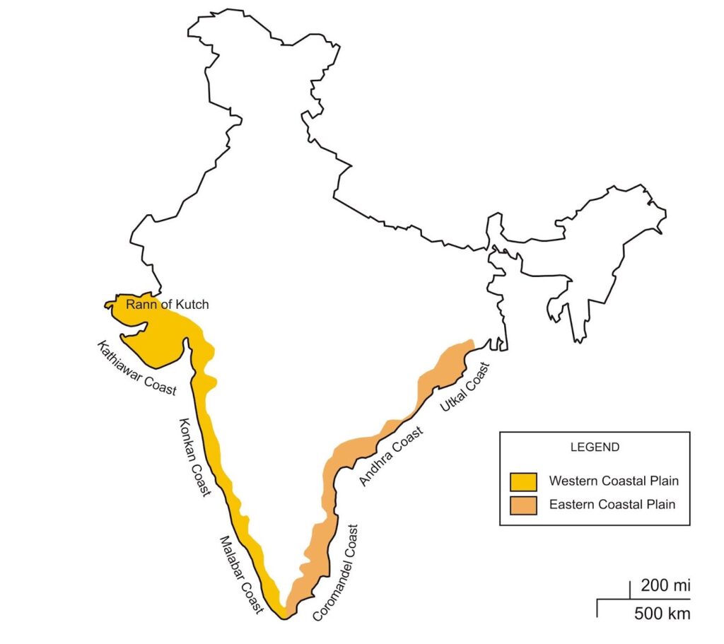
- India has the sea on three of its sides, and its coastal plains lie on either side of the Deccan Plateau, along the western and eastern coasts.
- They run for about 6,000–6,150 km, from the Rann of Kutch in the west to West Bengal in the east. The two plains meet at Kanniyakumari.
- Length of the coast: the figure long in use was 7,516.6 km, often split as 6,100 km on the mainland and 1,197 km on the Andaman, Nicobar and Lakshadweep islands, though those two parts do not add up to the total.
- The figure was re-assessed in 2025 to 11,098.81 km, chiefly because of a change in method and map scale, a change traced State by State for the coastline of India.
- Origin: the straight, regular coastline is usually traced to the faulting of Gondwana land during the Cretaceous.
- The coast touches 13 States and Union Territories.
- There are two broad divisions: the Western Coastal Plains along the Arabian Sea, and the Eastern Coastal Plains along the Bay of Bengal.
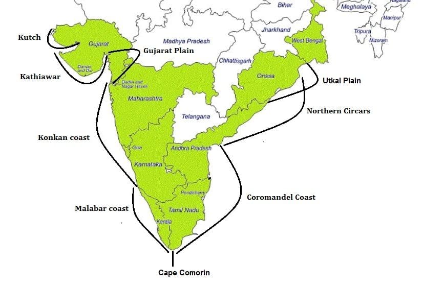
- “Orissa” on this map is Odisha. “Kutch” is the same as Kachchh.
| Aspect | Western Coastal Plain | Eastern Coastal Plain |
|---|---|---|
| Between | Western Ghats and Arabian Sea | Eastern Ghats and Bay of Bengal |
| Extent | Rann of Kachchh to Kanniyakumari | Subarnarekha to Kanniyakumari |
| Evolution | Rifting from Madagascar about 88 million years ago, then the Seychelles | Rifting from Antarctica about 120 million years ago |
| Width | About 65 km on average | About 120 km on average |
| Rivers | Short, swift, ending in estuaries | Long, slow, ending in deltas |
| Coast | Coves, creeks, cliffs; submergent Konkan, emergent Malabar | Straight, sandy, with bars and lagoons; emergent in the south-east |
| Harbours | More natural harbours | Few natural harbours |
| Rain | South-west monsoon | Both south-west and north-east monsoons |
Coastal Plains of India: West Coast
- The west coast strip reaches from Cape Comorin (Kanniyakumari) up to the Gulf of Cambay (Gulf of Khambhat).
- A narrow strip, usually put at 50–100 km (31–62 miles) wide, is squeezed between the Arabian Sea and the Western Ghats.
- It extends from Gujarat through Maharashtra, Goa, Karnataka and Keralam (Kerala).
- From north to south, it divides into the Konkan coast, the Karnataka coast and the Keralam coast.
- Rivers: mostly rising in the Western Ghats, they are fast-flowing, usually perennial, and end in estuaries.
- Major ones reaching the sea are the Tapti (Tapi), Narmada, Mandovi and Zuari.
- Make-up: alluvium brought down by short streams from the Ghats.
- Coastline: dotted with many coves (very small bays), creeks (narrow, sheltered waterways such as inlets in a shoreline or channels in a marsh) and a few estuaries, which are treated with other marine landforms.
- Of these estuaries, the Narmada’s and the Tapi’s are the main ones.
- The Keralam (Malabar) coast carries lakes, backwaters and lagoons, with Vembanad Lake as the biggest.
- Vegetation is mostly deciduous, and the Malabar Coast moist forests form a distinct ecoregion.
Western Coastal Plains of India
- They stretch Rann of Kachchh to Kanniyakumari, north to south.
- These are narrow plains averaging about 65 km, tightest in the middle and somewhat broader at the two ends.
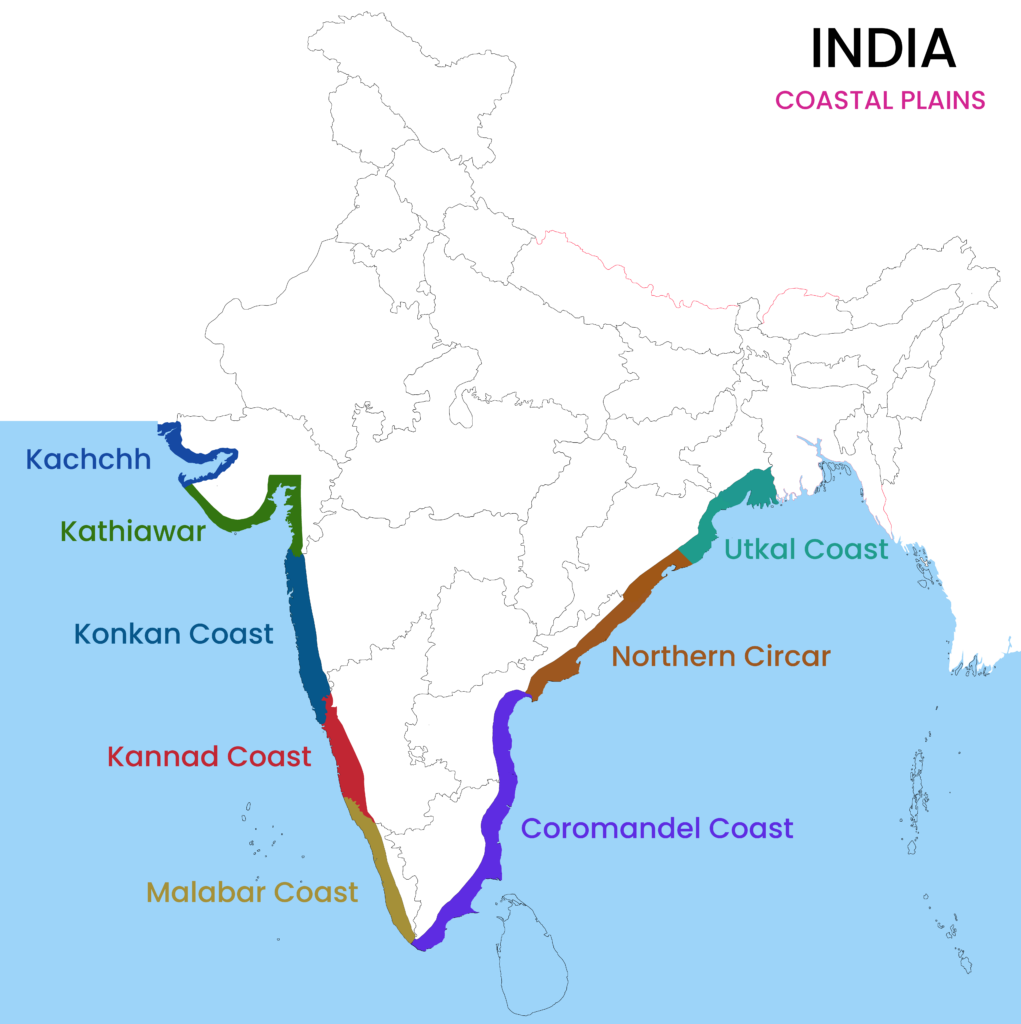
- They are mainly divided into four categories:
- Kachchh and Kathiawar coast
- Konkan coast
- Kanada coast
- Malabar coast
| Unit | Length | Width | Marks |
|---|---|---|---|
| Konkan Plain | About 500 km | 50–80 km | Marine erosion, creeks |
| Karnataka Coastal Plain | About 225 km | 30–50 km | Spurs near the coast, waterfalls |
| Malabar (Kerala) Plain | About 500 km | Up to 96 km | Lagoons, backwaters, spits |
Kutch and Kathiawar Region
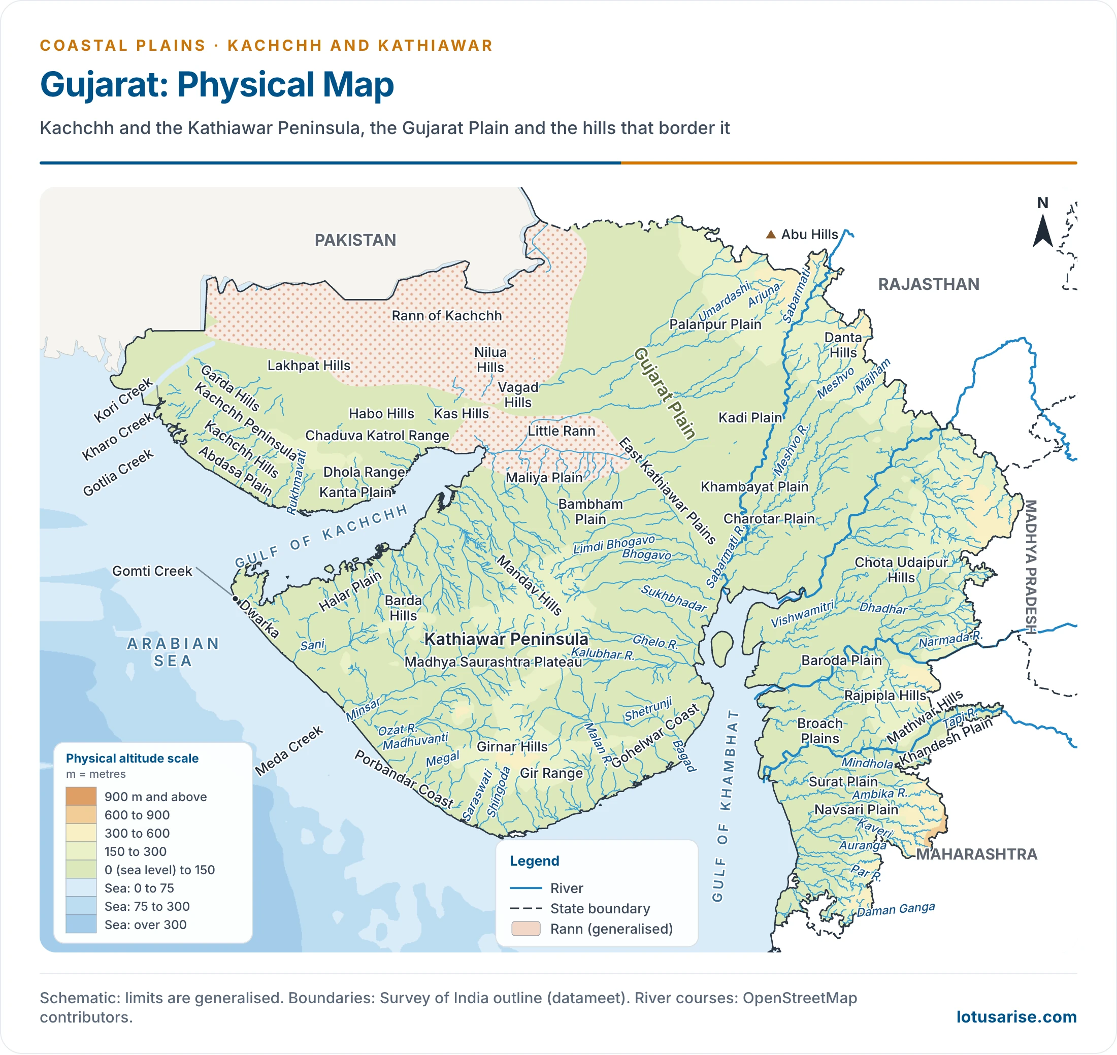
- Some geographers set Kutch and Kathiawar apart as an extension of the Peninsular plateau: Deccan Lava makes up Kathiawar, and Kutch holds Tertiary rocks. On that view, the true plain runs about 1,600 km from Surat to Kanniyakumari.
- Most still count them with the Western Coastal Plains, since they have been levelled down and lie close to the coast.
- Kutch Peninsula was once an island among seas and lagoons. The Indus, then flowing through this area, later filled these with sediment.
- Recent scarcity of rain has made it an arid and semi-arid landscape, with wind at work everywhere: coastal dunes and sandy plains broken by bare rocky hills.
- Great Rann: the salt-soaked plain north of Kutch, about 300 km long and covering about 21,500 sq km.
- It stands barely above sea level. The Banas and Luni flood it in the rains, and tides reach its lowest parts.
- Its surface is sun-baked dark silt under a salt crust.
- Little Rann: the southern continuation, along the coast to the south-east of Kachchh.
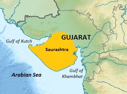
- Kathiawar Peninsula: south of Kachchh, averaging under 200 m, flanked on the north-east and east by the Nal Basin and the Little Rann.
- At the centre rises the Mandav Hills highland, with small streams running off on every side, a radial drainage pattern.
- Mt. Girnar (1,117 m) is the highest point. It is of volcanic origin, an igneous complex intruded into the basalt late in the Deccan Trap period.
- Gir Range: in southern Kathiawar, densely forested and famous as the home of the Gir (Asiatic) lion. The 2025 count found 891 lions across 11 districts, so the species now ranges well beyond the forest.
Gujarat Plain
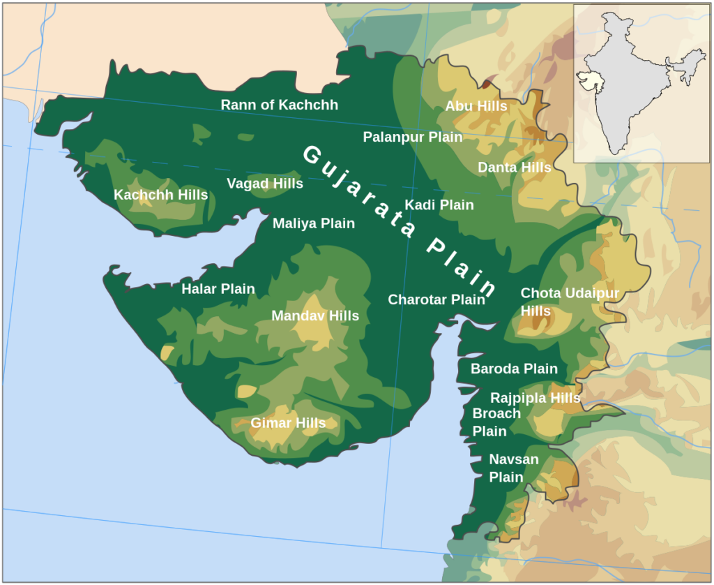
- East of Kachchh and Kathiawar, it tilts towards the west and south-west and stands nowhere above 150 m. It resembles an extension of the Indo-Gangetic lowland into the Peninsula.
- The Narmada, Tapi, Mahi and Sabarmati built it, and it covers southern Gujarat and the shores of the Gulf of Khambhat.
- The eastern part is fertile enough for farming. Much of the land near the coast has a cover of wind-blown loess, which older accounts gloss as heaps of sand, though loess is properly wind-laid silt.
- Saline marshes near the coast flood at high tide.
Konkan Plain
- It follows the Gujarat plain southward, Daman to Goa, about 500 km long and 50–80 km wide.
- Marine erosion has shaped cliffs, shoals and reefs, and it has left islands offshore.
- Thane Creek around Mumbai is an important embayment (a recess in a coastline forming a bay) and an excellent natural harbour.
- Mumbai was an island, and reclamation has since joined it to the mainland.
- South of Mumbai, sandy bays and coves lie between headlands.
- Behind the coastal belt, parallel ridges of 450–600 m guide the lower courses of the Vaitarna, Ulhas and Amba.
- Lateritic hillocks rise to about 100 m.
Karnataka Coastal Plain
- It extends from Goa to Mangalore, about 225 km.
- It is a narrow plain averaging 30–50 km, reaching a maximum of 70 km near Mangalore.
- Spurs of the Ghats come so close at about 14°N that the lowland shrinks to 5–7 km, and the crest stands only 13 km from the sea.
- At some places streams from the Western Ghats descend steep slopes as waterfalls.
- The Sharavati forms Gersoppa (Jog) Falls. The older figure is 271 m, and official sources now give 253 m.
- For scale: Angel Falls (979 m) in Venezuela is officially the highest waterfall on earth, and Tugela Falls (948 m) in the Drakensberg, South Africa, is usually ranked second. Some recent measurements dispute that order.
- Marine topography is well marked on this coast.
Malabar Plain (Kerala Plain)
- Known as both the Kerala Plain and the Malabar Plain, it covers about 500 km, Mangalore to Kanniyakumari.
- It is far broader than its Karnataka neighbour, reaching 96 km, and it is low-lying, nowhere above 30 m.
- Lakes, lagoons, backwaters and spits are its significant features.
- Backwaters, locally kayals, are shallow lagoons or sea inlets running parallel to the coast.
- The largest is Vembanad Lake, 5–10 km wide and about 75 km long, with a spit stretching 55 km. Kochi stands at its opening to the sea.
- Canals link these lagoons into inland waterways from the Ponnani to Thiruvananthapuram.
Coastal Plains of India: East Coast
- It lies between the Eastern Ghats and the Bay of Bengal, from the Ganga delta to Kanniyakumari.
- It is marked by the deltas of the Mahanadi, Godavari, Krishna and Cauvery.
- Chilka Lake and Pulicat Lake (lagoons) are its important features.
- Temperature often exceeds 30°C (86°F), with high humidity.
- Rain: the region gets both the north-east and south-west monsoons. The south-west monsoon splits into two branches:
- The Bay of Bengal branch moves north, crossing north-east India in early June.
- The Arabian Sea branch moves north and sheds much of its rain on the windward side of the Western Ghats.
- Annual rainfall averages 1,000–3,000 mm (39–118 inches). The plains are 100–130 km (62–81 miles) wide.
- Six regions are sometimes named: the Mahanadi delta, southern Andhra Pradesh plain, Krishna-Godavari deltas, Kanyakumari coast, Coromandel Coast and sandy coastal tracts.
Eastern Coastal Plains of India
- They run from the Subarnarekha river, on the West Bengal-Odisha border, down to Kanniyakumari.
- Most of the plain is alluvial filling of the littoral zone (the zone of the shore of a sea or lake) by the Mahanadi, Godavari, Krishna and Cauvery, whose deltas are among the largest.
- Unlike the west, these are extensive plains averaging 120 km: up to 200 km across the deltas, and 35 km between them.
- The western limit is broken, and roughly follows contours: 75 m in Odisha, 100 m in Andhra Pradesh, 150 m in Tamil Nadu.
- Its names are regional: Northern Circars for the Mahanadi-Krishna stretch, and Carnatic for the Krishna-Cauvery stretch.
- It divides into three categories:
- Utkal coast
- Andhra coast
- Coromandel coast
Utkal Plain
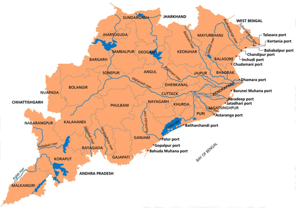
- The coast of Odisha, about 400 km long.
- The Mahanadi delta falls in it, with Cuttack at the delta’s head.
- Its most prominent feature is Chilka (Chilika) Lake, south of the delta.
- Long described as the country’s biggest lake, it is more exactly the largest brackish lagoon on India’s coast. The largest inland saline lake is Sambhar.
- Recorded figures run from 780 sq km (winter) to 1,144 sq km (monsoon), and the fuller lagoon record gives about 906 to 1,165 sq km. Silting and reclamation had shrunk it to about 760 sq km by the late 1990s.
- It has been a Ramsar site since 1981.
- South of the lake, low hills dot the plain.
Andhra Plain
- It follows the Utkal Plain southward as far as Pulicat Lake, some 40 km above Chennai.
- This lagoon, India’s second largest brackish lagoon, is barred by a long sand spit, Sriharikota Island, home of the ISRO launch facility.
- Its most significant feature is the delta of the Godavari and the Krishna.
- The two have fused into one physiographic unit.
- Together they have pushed about 35 km seaward in recent geological time. Kolleru Lake, once a lagoon at the shore, now lies far inland, a sign of coastal emergence.
- The straight coast badly lacks good harbours, Vishakhapatnam and Machilipatnam being the exceptions.
Tamil Nadu Plain
- It runs along the Tamil Nadu coast for 675 km, Pulicat Lake to Kanniyakumari, with a mean width of 100 km.
- The Cauvery delta is its chief feature, widening the plain to 130 km.
- Fertile soil and large-scale irrigation have made this delta the granary of South India.
Coastlines of Emergence and Submergence
- A coastline of emergence forms through uplift of the land or lowering of the sea. A coastline of submergence is the exact opposite.
- Bars, spits, lagoons, salt marshes, beaches, sea cliffs and arches are listed as typical features of emergence, and they appear on the coastal landforms list.
- East coast: especially its south-eastern part (Tamil Nadu), appears to be a coast of emergence.
- West coast: both emergent and submergent.
- The northern portion is submerged as a result of faulting, and the southern portion, the Keralam coast, is emergent.
- In short:
- Coromandel coast (Tamil Nadu): emergence.
- Malabar coast (Keralam): emergence.
- Konkan coast (Maharashtra and Goa): submergence.
Significance of the Coastal Plains and Coastlines
- Climate: the long coastline extends a favourable climate without extremes, suited to human development.
- Soil and crops: mostly fertile soils. Rice is the main crop, and coconut grows all along the coast.
- Ports and trade: big and small ports carry trade.
- Older accounts credit them with 98% of trade. The official figure now is about 95% by volume and 70% by value.
- Minerals: the sedimentary rocks are said to hold large deposits of mineral oil, a source for the marine economy.
- Keralam’s beach sands hold monazite, a nuclear fuel source.
- Fishing supports many coastal people.
- Salt: the low-lying coast of Gujarat is known for it.
- Ecosystems and tourism: mangroves, coral reefs, estuaries and lagoons support ecology and offer great tourism potential.
Previous Year Questions
2009Distinguish between the West and East coasts of India in terms of their evolution, present topography and drainage pattern.





So good knowledge
Very good content thank you so much sir ji
Gratitude,ThankYou a Billion ton…Salute your Selfless Service Efforts Sir!