

- A boundary is a precise line marking the outer limit of a state’s sovereignty. A frontier is a zone of varying width where the settled, integrated parts of two states fade out and meet.
- The laws of boundaries are less strict laws than a set of principles: Friedrich Ratzel’s frontier as a peripheral organ, Lord Curzon’s natural and artificial frontiers, Stephen B. Jones’s stages of boundary making and Richard Hartshorne’s genetic types.
- Boundaries are classified in two main ways: genetically, by their relation to the cultural landscape when drawn, and morphologically, by what they follow on the ground.
- Almost all of the earth’s land is now enclosed by lines. The live questions are about who and what those lines let through, and about lines at sea.
Frontier and Boundary

Boundary
- A boundary demarcates the outer limits of a territory under the sovereign jurisdiction of a state. The word also applies to economic and social units, such as a ghetto.
- It marks the physical limit of sovereignty and jurisdiction. It is a sign of integration and is oriented inward.
- Its main traits:
- Fixed, not grown: it is a legal-political line set by decision-makers, keeping the enemy out and the resources in.
- Fit for the modern state: all within it is bound by common law, economy, idea or creed under a government in effective control.
- Reached by expansion: states often reach a line by pushing into frontiers until natural limits stop them, as the USA did in moving west to the Pacific.
- A mark of difference: it signals differences in goals, ideology, structure and interests from those of the neighbour.
- Frontier traits may linger: in sparsely peopled areas a line causes little friction, as with stretches of the Spain–Portugal boundary.
Frontier
- A frontier is a transitional zone separating the ecumenes (the fully developed, politically and economically integrated parts) of neighbouring states.
- It is often uninhabited or thinly peopled land of low use at current technology, so neither side has felt the need to fix an exact limit.
- The word implies what lies in front. It was a physical and moral idea of looking and moving outward.
- A settlement frontier marks the farthest advance of settlement within a state. A political frontier is where the limit of the state coincides with the limit of settlement.
- In earlier times states were separated by areas, not lines. The intervening belt prevented direct contact. European penetration into Natal and, today, Antarctica show the frontier as a space beyond defined limits.
- Where two states advance from opposite sides, the frontier closes and boundary disputes begin.
The Two Compared
- Ladis K. D. Kristof (1959) gave the classic statement of the contrast in “The Nature of Frontiers and Boundaries”.
| Basis | Frontier | Boundary |
|---|---|---|
| Form | Areal: a zone of variable width | Linear: a precise line |
| Orientation | Outer-oriented, toward danger and prize | Inner-oriented, set by the central government |
| Force | Centrifugal | Centripetal |
| Role | Integrating: mutual exchange across it | Separating: law and control change at it |
| Nature | Geographical; a fact of life, unique like history | Political and legal; no material life of its own |
| Time | Largely of the past | Belongs to the modern state |
| Mobility | A physical or cultural frontier stays in place | Can be moved by power or treaty |
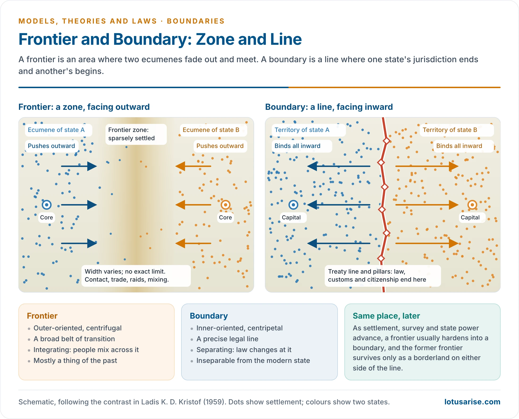
- In the present context the two terms still describe different things on the ground.
- The India–Bangladesh line is a hard boundary: surveyed, pillared and largely fenced.
- The Line of Actual Control with China keeps frontier traits: no agreed line, patrols that overlap, and a stand-off from 2020. The patrolling arrangement of 21 October 2024 for Depsang and Demchok dealt with friction, not with where the line runs.
Why Frontiers Gave Way to Boundaries
- The territorial state: sovereignty, taxation, customs and citizenship all need an exact limit.
- Filling of empty land: Curzon foresaw the end of the process in 1907, once the vacant spaces were taken and every frontier defined.
- Colonial rivalry: European powers drew lines to avoid colliding with one another, above all after the Berlin Conference (1884–85).
- Survey and mapping: geodesy, then air and satellite survey, made it possible to fix a line through land no one had walked.
- Resource value: waste land acquires value once minerals appear. Saudi Arabia and Yemen carried a treaty line through the Rub al Khali only in 2000 (Treaty of Jeddah).
- Military change: aircraft and missiles ended the protective value of an empty belt.
- International law: territorial integrity became a norm. Almost all African states accepted their colonial lines on joining the Organisation of African Unity in the 1960s; Somalia and Morocco did not.
- What remains: Antarctica, where the Antarctic Treaty (1959) froze claims, and the high seas and deep sea bed. Outer space and cyberspace are frontiers in the older sense.
Laws and Principles
- J. R. V. Prescott (1987) drew the sober conclusion: efforts to produce reliable laws of boundary behaviour have failed, while procedures for studying boundaries have succeeded. The “laws” below should be read in that spirit.
Friedrich Ratzel: The Peripheral Organ
- In “The Laws of the Spatial Growth of States” (1896), Friedrich Ratzel (1844–1904) called the boundary the peripheral organ of the state. Within his organic theory of the state, it carries growth, protects the body and changes with it.
- For him the boundary was an abstraction and the border area the reality, a skin that both defends and allows exchange.
- A fixed line was only a temporary halt in expansion. Politische Geographie (1897) added two laws:
- Boundaries evolve toward simplification, and so toward shorter lines.
- Boundaries of larger areas embrace those of smaller ones.
Lord Curzon: Frontiers (1907)
- George Nathaniel Curzon, Viceroy of India from 1899 to 1905, gave the Romanes Lecture at Oxford on 2 November 1907. He called frontiers “the razor’s edge on which hang suspended the modern issues of war or peace”.
- He divided frontiers into natural and artificial:
- Natural: sea (the most effective), deserts, mountains, rivers and forests. He warned of “natural frontiers” claimed from ambition or sentiment, a cause of many wars.
- Artificial, ancient: walls and empty belts of severance.
- Artificial, modern: astronomical, mathematical and referential lines, which are the geometrical boundaries below.
- He traced how power extends beyond a line. Spheres of interest harden into spheres of influence, then protectorates, then incorporation. Buffer states keep rivals apart.
- Threefold frontier of British India: the administrative border, the Durand Line as the frontier of active protection, and the Afghan border as the outer strategic frontier.
- Sir Thomas Holdich’s Political Frontiers and Boundary Making (1916) drew on field practice. Good maps must come first; the straight line is the worst expedient; watersheds and defensible lines are best.
Stephen B. Jones: Stages of Boundary Making (1945)
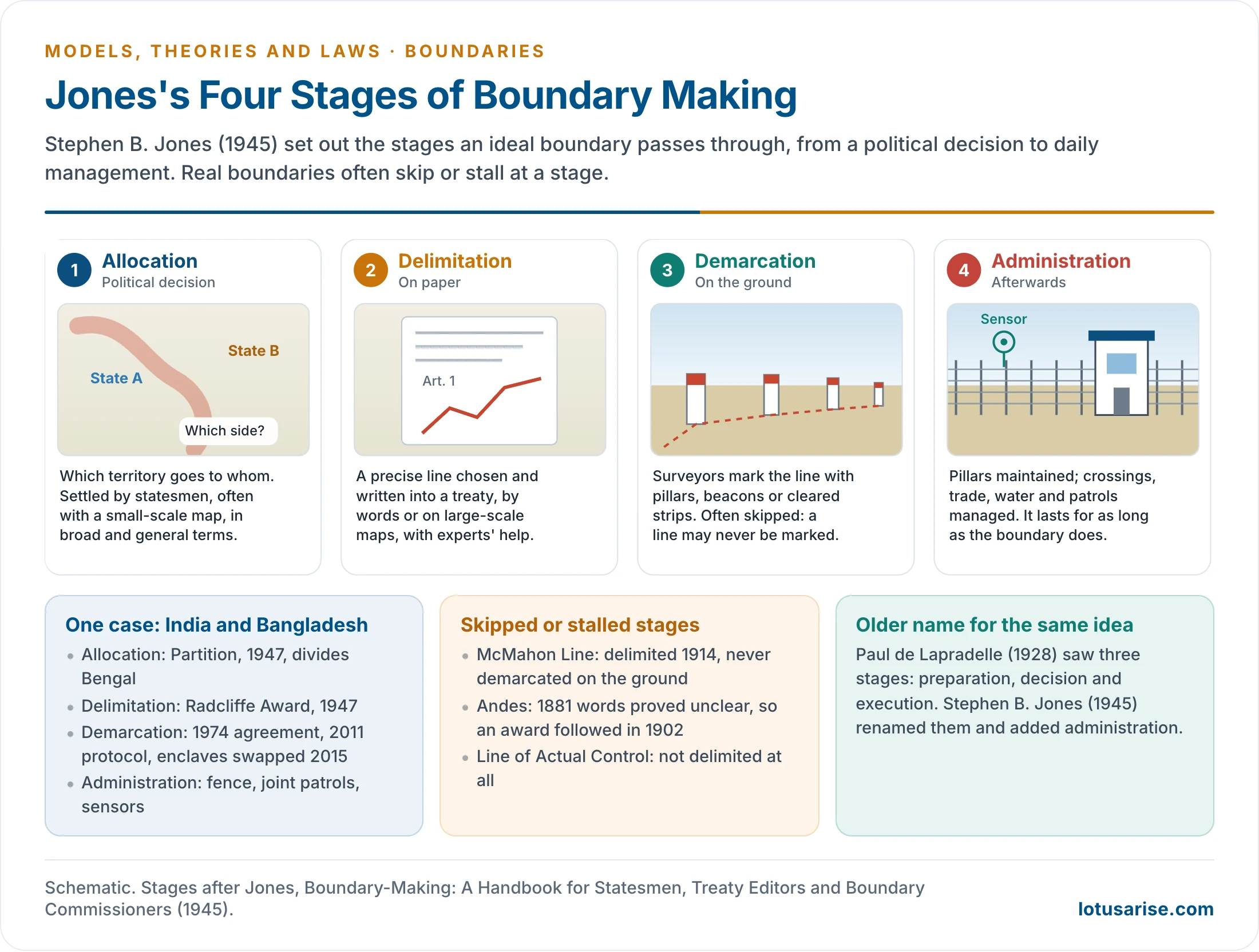
- Paul de Lapradelle (1928) named three stages: preparation, decision and execution. Stephen B. Jones, in Boundary-Making (1945), renamed them and added a fourth.
| Stage | What happens | Who acts | Example |
|---|---|---|---|
| Allocation | Political decision on who gets which territory | Statesmen | Partition of Bengal, 1947 |
| Delimitation | Exact line chosen and written into a treaty or award | Negotiators, experts | Radcliffe Award, 1947 |
| Demarcation | Line marked on the ground by pillars or cleared strips | Surveyors, joint commissions | India–Bangladesh agreement 1974, protocol 2011 |
| Administration | Upkeep, crossings, water, trade, patrols | Border forces, agencies | Fence, joint patrols, sensors |
- Not every boundary passes through all four. The McMahon Line was delimited in 1914 and never demarcated on the ground, and China repudiated the Simla Convention after its delegate had initialled it.
- Faults at an early stage return later. Unclear words in delimitation led to the dispute over the Andes.
Boggs and Boundary Functions
- Samuel Whittemore Boggs, Geographer of the US Department of State, argued in 1932 that boundary functions are not static but change over time.
- In International Boundaries (1940) he held that these functions are negative and restrictive, a nuisance to trade and contact. Yet no boundary is fully sealed: a kind of osmosis takes place across it.
Three Readings and Three Processes
| View | Boundary seen as | Linked with |
|---|---|---|
| Organismic | A moving skin of a growing state | Ratzel |
| British imperial | A strategic, defensible line, with buffers beyond | Curzon, Holdich |
| Contractual | A legal product of agreement between sovereign states | Lapradelle, treaty practice |
| Core-periphery | The outer edge of a national core, often neglected and militarised | Later political geography |
- Boundaries also differ by how they came about:
- Arbitrary process: imposed from outside, as at Berlin in 1884–85.
- Arbitration process: a third party decides, as with the Andes (award of 1902) and the Rann of Kutch (19 February 1968), where a tribunal gave India about 90% of the disputed area.
- Evolutionary process: slow adjustment over centuries, as with many older European lines.
Classification
Genetic Classification
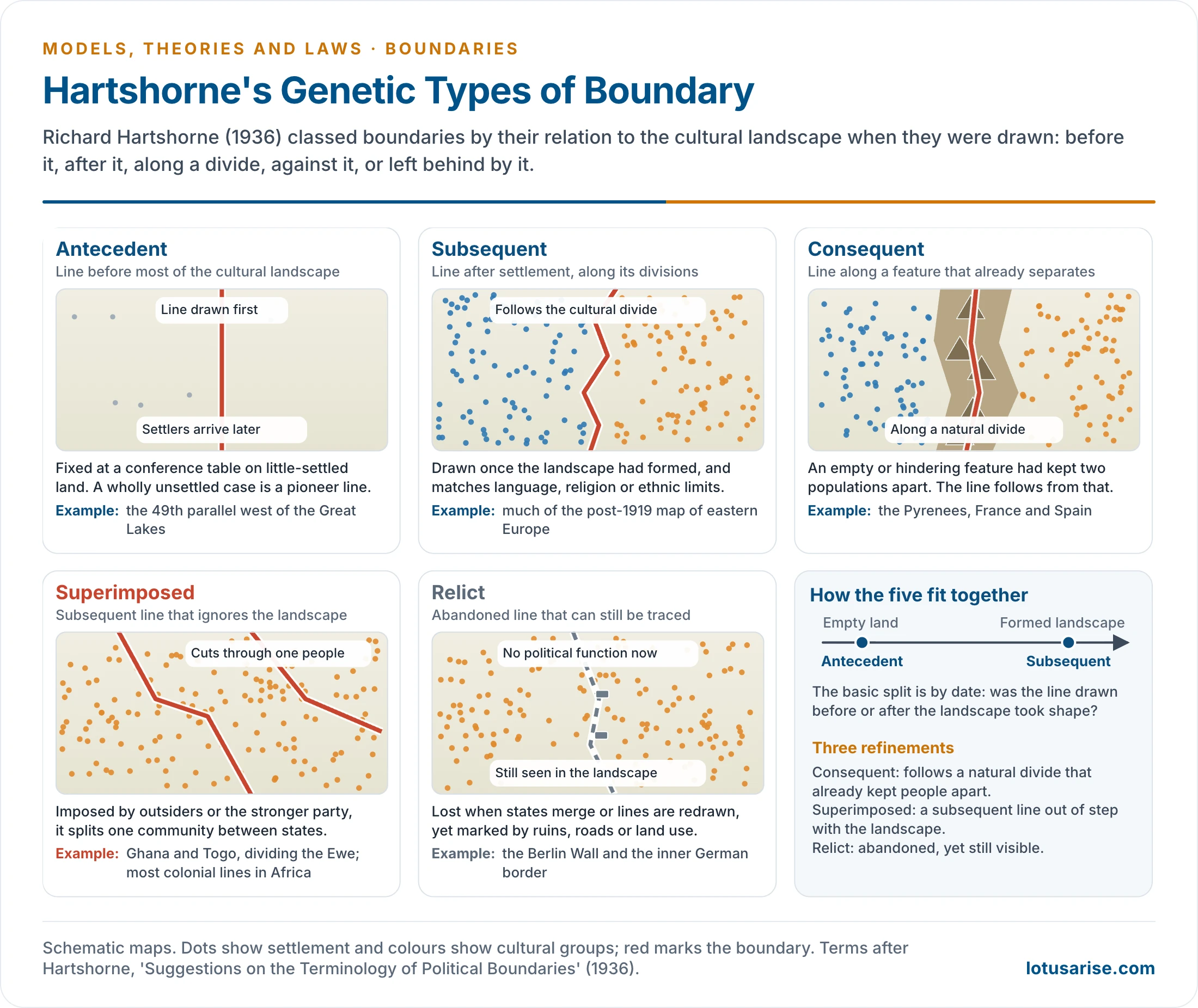
- It is based on the relationship between a boundary and the cultural landscape at the time it was drawn. The analogy comes from river terms in physical geography, and it is an imperfect one.
- Richard Hartshorne (1899–1992) set out the terms in “Suggestions on the Terminology of Political Boundaries” (1936), after his study of Upper Silesia (1933) and talks with Derwent Whittlesey and Stephen Jones.
| Type | Meaning | Examples |
|---|---|---|
| Antecedent | Drawn before most of the cultural landscape developed. A line drawn before any settlement is a pioneer boundary | 49th parallel west of the Great Lakes; agreed at the conference table in the New World |
| Subsequent | Drawn after the landscape evolved, and in step with it, often by language or religion | Most of eastern Europe after 1919; India–Pakistan and India–Bangladesh by religious divide |
| Consequent | Follows a natural feature that had already kept populations apart, through emptiness or hindrance | Pyrenees between France and Spain |
| Superimposed | A subsequent line that does not conform to the landscape; imposed by outsiders or the stronger party | Colonial Africa; the Ghana–Togo line dividing the Ewe; truce lines such as Korea’s 1953 armistice line |
| Relict | Has lost its political function but can still be seen | Berlin Wall (1961–89) and the inner German border |
- The types can overlap. The Radcliffe Line followed a religious divide, yet it was drawn in weeks by an outsider and cut through Punjabi and Bengali society, so it also has a superimposed character.
- Lines become entrenched. Hartshorne noted that once a line is accepted, it tends to become part of the cultural structure of the area. African states’ acceptance of colonial lines is the large-scale case.
- Hartshorne’s own relict is an abandoned antecedent line. Later writers use the term for any abandoned boundary.
Morphological Classification
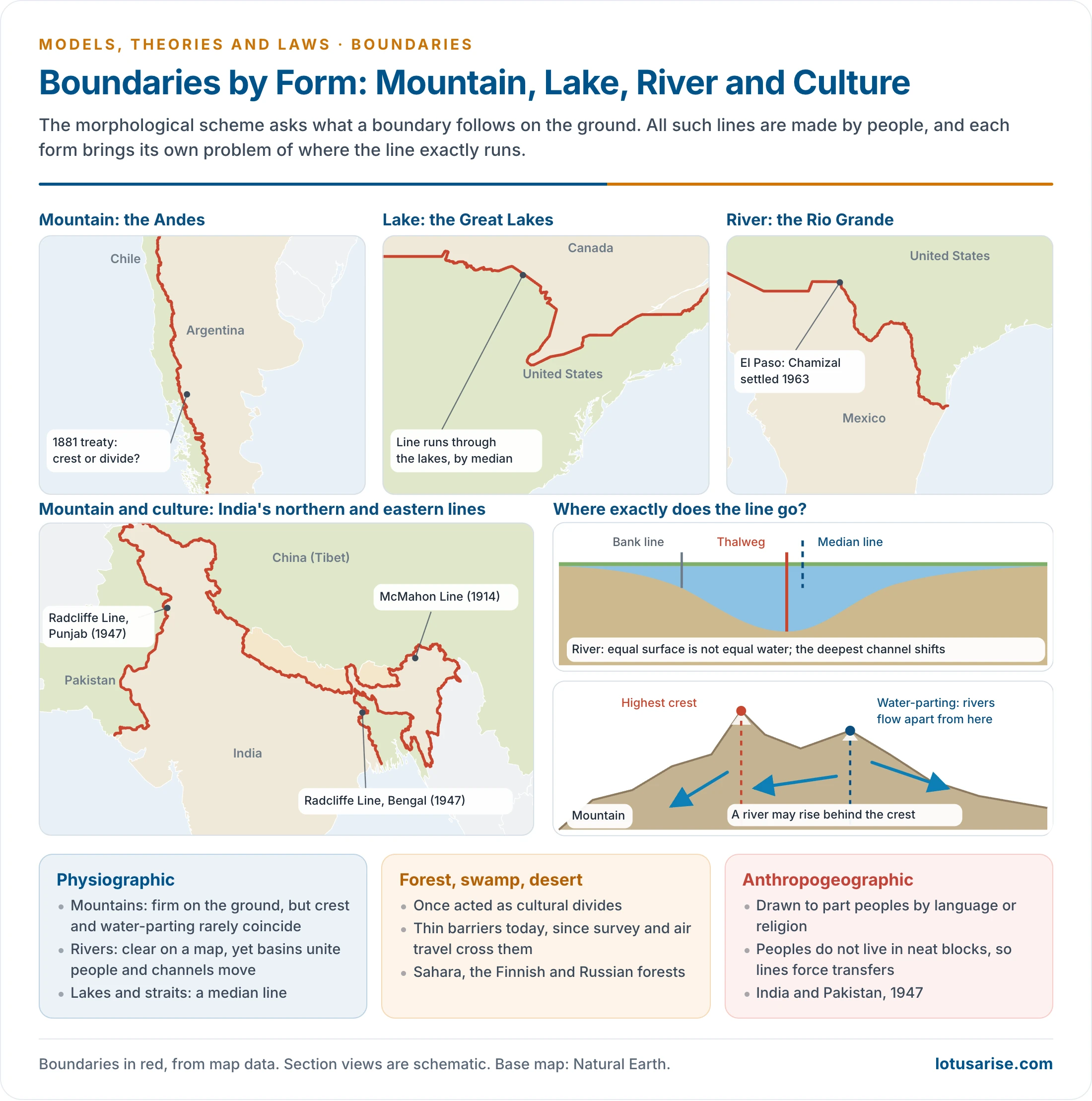
- It asks what a boundary follows on the ground. Boggs (1940) grouped boundaries as physical, geometrical, anthropogeographic and complex. Most real boundaries use more than one criterion, so most are complex.
- “Natural” and “artificial” mislead here: all boundaries are made by people, and a physical feature only provides the site.
Mountain Boundaries
- Long favoured: they are firm on the ground and were thought to be stable barriers.
- Air power and modern transport have cut their protective value, as the crossing of the Himalaya in 1962 showed.
- The siting problem: most ranges lack one clear crest, and transverse valleys and parallel ranges complicate it. Crest and water-parting often differ.
- Andes: the 1881 treaty ran the line along the highest crests that divide the waters. Over long stretches in Patagonia these do not coincide. King Edward VII’s award of 1902, based on a survey led by Holdich, gave a compromise.
- Himalaya: the Indus, Sutlej and Brahmaputra rise beyond the highest crests and cut through them.
River Boundaries
- Advantages: clearly marked on the map, nearly linear and once a line of defence.
- Disadvantages: river basins unite people, since they are lines of movement and dense settlement on fertile plains. A boundary along a river disrupts communities and water use, as in the Indus basin and on the India–Bangladesh border.
- Where to run the line:
- Median line: equal division of the surface, not of the volume of water.
- Thalweg or navigable channel: fair to shipping, but it zigzags and moves.
- Bank: gives the whole river to one side.
- Channels shift. The Rio Grande moved land between the USA and Mexico until the Chamizal Convention (1963) relocated the channel and transferred 437 acres to Mexico. Within India, the Ghaghara and Ganga have caused similar disputes between Uttar Pradesh and Bihar.
Lakes, Straits, Forests, Swamps and Deserts
- In lakes and straits, boundaries are normally median lines from the coasts, as in the Great Lakes.
- Deserts, forests and swamps act as cultural divides. The Sahara long separated Mediterranean North Africa from sub-Saharan Africa. Forests mark parts of the Finnish–Russian and Polish–Lithuanian borderlands, and marshes marked the Belarus–Poland line during the two World Wars.
Anthropogeographic Boundaries
- Drawn to separate communities by language, religion or tradition. They rose to prominence after the First World War, when central and eastern Europe were redrawn on the principle of self-determination.
- People do not live in neat blocks, so such lines can force large-scale transfers. 1947 caused refugee flows, great hardship and a break in regional economic unity.
Geometrical Boundaries
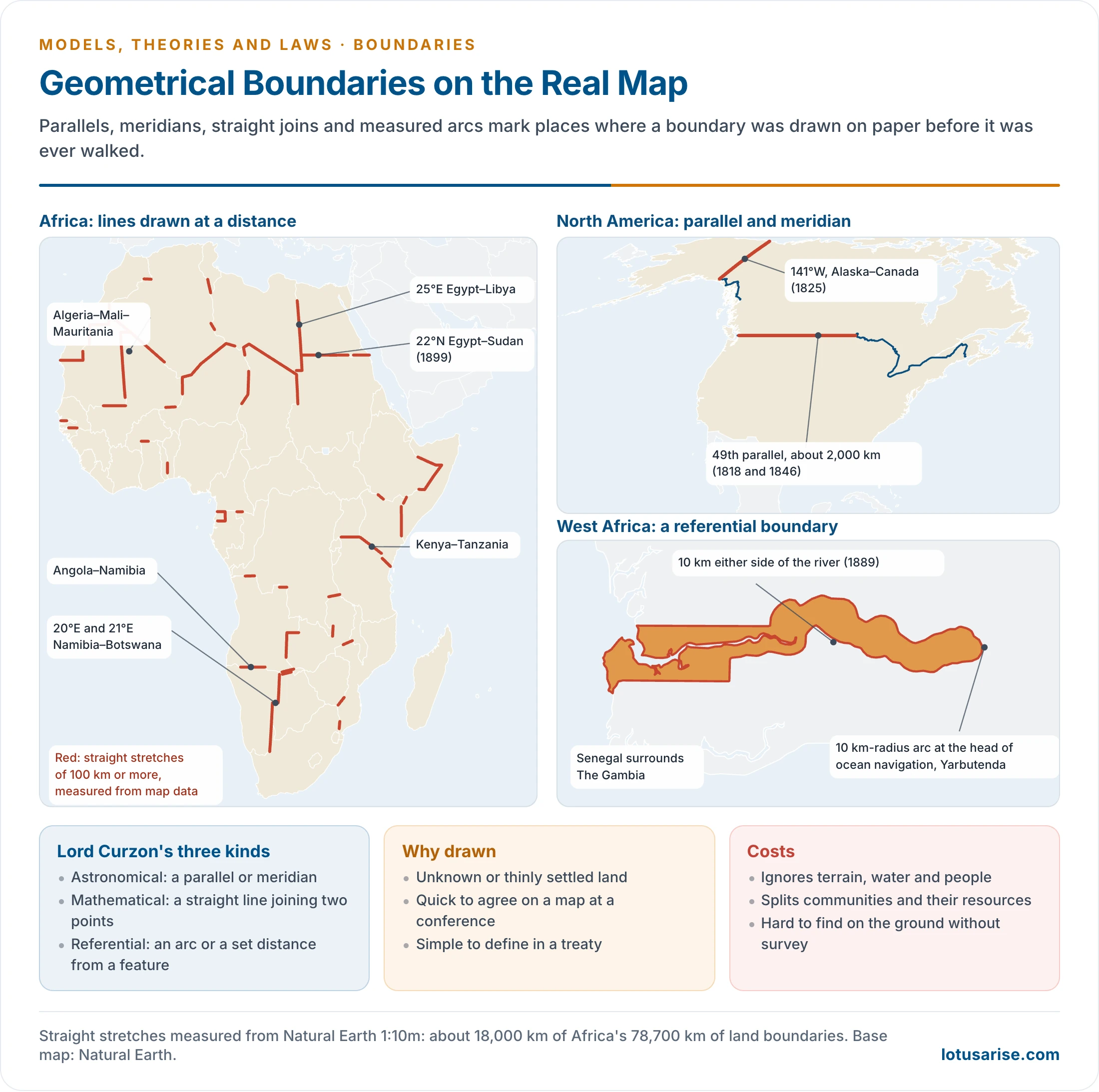
- These follow straight lines, parallels, meridians or measured arcs, regardless of terrain or people.
- Curzon’s three kinds:
- Astronomical: along a parallel or meridian.
- Mathematical: a straight line joining two fixed points.
- Referential: an arc or set distance from a point or feature.
| Boundary | Kind | Origin |
|---|---|---|
| USA–Canada, 49th parallel | Astronomical | 1818, extended to the Pacific in 1846; about 2,000 km |
| Alaska–Canada, 141°W | Astronomical | 1825 |
| Egypt–Sudan, 22°N | Astronomical | 1899 agreement |
| Namibia–Botswana, 20°E and 21°E | Astronomical | Colonial lines |
| Libya–Chad, Algeria–Niger, Kenya–Tanzania | Mathematical | Colonial conference lines |
| The Gambia–Senegal | Referential | 1889: 10 km either side of the river, with a 10 km-radius arc at its eastern end |
| Korea’s 38th parallel | Astronomical | 1945 division, replaced by the 1953 armistice line |
- Africa is the classic region. Alberto Alesina and colleagues (2011) report that 80% of African borders follow latitudes and longitudes. By length, straight runs of 100 km or more make up about 18,000 km of the continent’s 78,700 km of land boundaries (measured from Natural Earth).
- An Indian case: in the Rann of Kutch dispute, Pakistan claimed a line roughly along the 24th parallel, while India claimed the northern edge of the Rann. The 1968 tribunal did not adopt the parallel.
- Why they were used: unknown or thinly settled land, speed at a conference table, and ease of definition.
- Merits: simple to state, and they cause little friction in empty land.
- Demerits:
- They ignore terrain, water and people. African groups split by colonial lines number 177 in one count (Asiwaju, 1985).
- Stelios Michalopoulos and Elias Papaioannou (2016) link such partition to more conflict and lower development among split groups.
- They are costly to find on the ground without survey.
Boundaries Today
Why Boundaries Matter in Geopolitics
- They define sovereignty and security: the limit of law, army and tax.
- They allocate resources: oil, water, fish, sea-bed minerals.
- They carry identity: maps and fences express the nation.
- They shape economy: customs, tariffs and market reach. Border regions often become peripheral.
- Scholars now study bordering as a process. In the 1990s, Kenichi Ohmae’s The Borderless World (1990) suggested that lines were fading. David Newman and Anssi Paasi (1998) and later work showed instead that boundaries are being rebuilt, especially after 9/11.
Inclusion and Exclusion
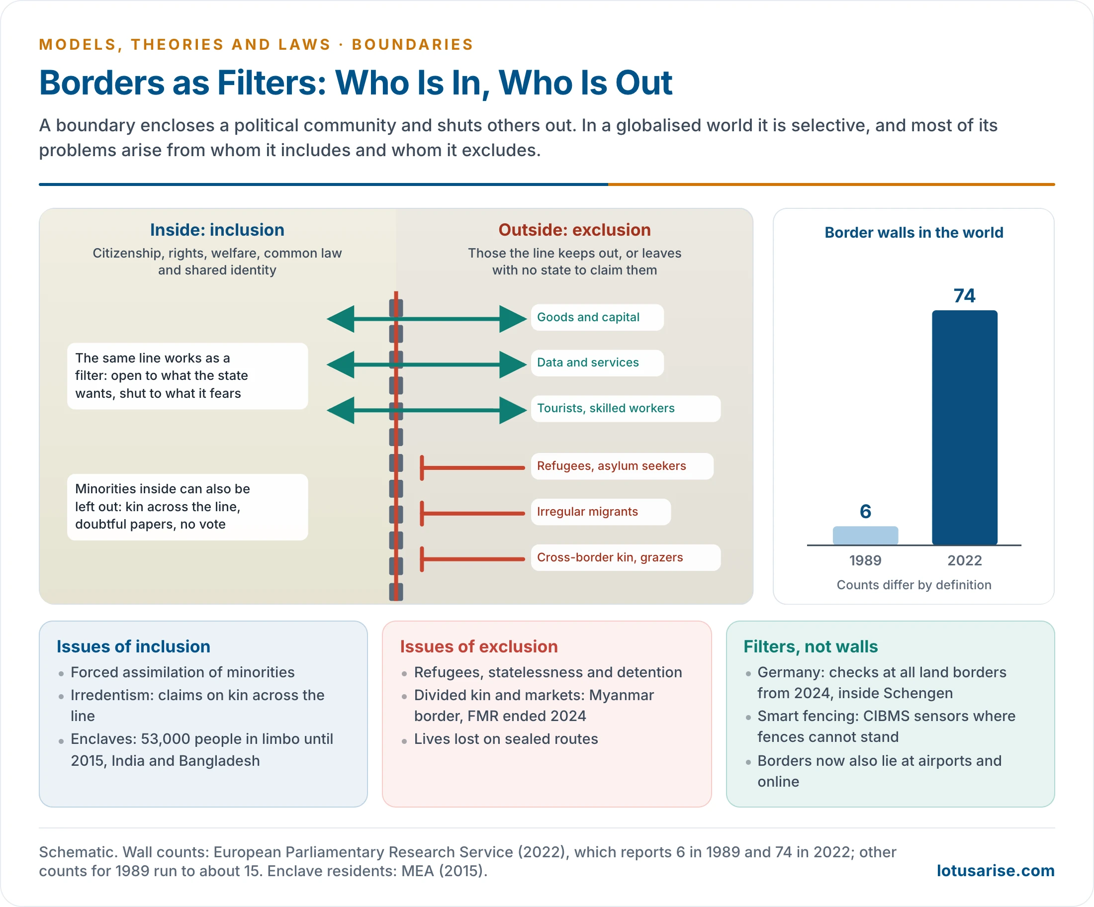
- A boundary includes by binding those inside into a political community. It excludes by treating those outside as foreign.
| Aspect | Issues that develop | Examples |
|---|---|---|
| Inclusion of minorities | Forced assimilation, unrest, separatism | Kurds across four states |
| Inclusion of kin claims | Irredentism, claims across the line | Somalia rejected colonial lines in the 1960s |
| Exclusion from citizenship | Statelessness, detention, doubtful papers | 19.06 lakh left out of Assam’s final NRC (2019) |
| Enclaves | People cut off from their own state | 111 Indian and 51 Bangladeshi enclaves with about 53,000 residents, exchanged in 2015 |
| Exclusion of migrants | Refugee crises, deaths on sealed routes | EU and US–Mexico borders |
| Division of kin and markets | Lost livelihoods, smuggling | India ended the Free Movement Regime with Myanmar in 2024 and plans to fence all 1,643 km |
- Borders act as filters. Goods, capital, data and skilled workers pass; refugees and the poor are stopped.
- The trend is toward hardening. The European Parliamentary Research Service reports 6 border walls in 1989 and 74 in 2022; other counts for 1989 run to about 15.
- Germany has checked all its land borders inside the Schengen area since September 2024, with the current notification running to March 2027.
- Smart fencing takes the filter further. India’s Comprehensive Integrated Border Management System uses sensors, radar and sonar. Its BOLD-QIT project covers about 61 km of the riverine border at Dhubri, where a fence cannot stand.
- Boundary work has also moved away from the line, to airports, databases and visa offices.
Maritime Boundaries
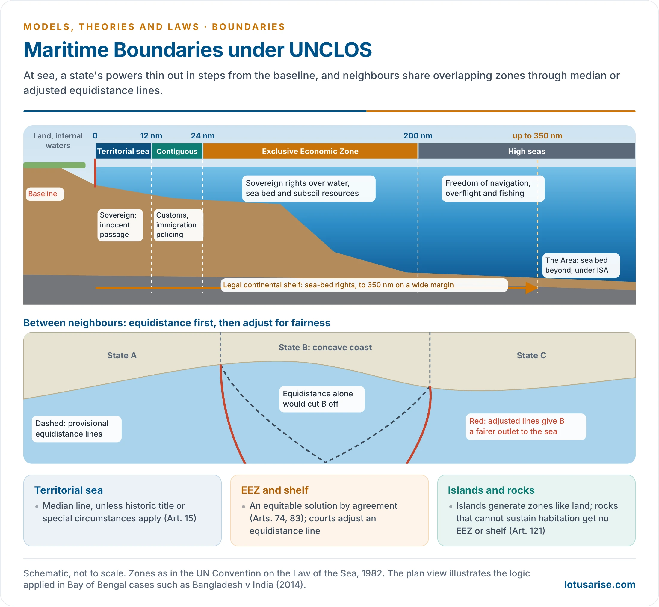
- Before 1958, the law of the sea rested on custom. Three UN conferences followed, and the third produced the UN Convention on the Law of the Sea, opened for signature at Montego Bay on 10 December 1982 and in force since 16 November 1994.
| Zone | Limit from baseline | Coastal state’s powers |
|---|---|---|
| Internal waters | Landward of baseline | Full sovereignty |
| Territorial sea | 12 nm | Sovereignty, with innocent passage |
| Contiguous zone | 24 nm | Customs, fiscal, immigration, sanitary control |
| Exclusive Economic Zone | 200 nm | Sovereign rights over resources |
| Continental shelf | 200 nm, up to 350 nm on a wide margin | Sea-bed rights |
| High seas and the Area | Beyond | Freedoms of the sea; sea-bed minerals under the International Seabed Authority |
- Delimitation: the territorial sea uses the median line. The EEZ and shelf need an equitable solution, and courts now start from an equidistance line and adjust it.
- Islands generate zones like land, but rocks that cannot sustain habitation get no EEZ or shelf.
- India: the Bay of Bengal award (7 July 2014) gave Bangladesh 19,467 of 25,602 sq km in dispute. Agreements of 1974 and 1976 with Sri Lanka settled the line, and Kachchatheevu fell on the Sri Lankan side; fishing around it is still an irritant.
- South China Sea: the award of 12 July 2016 found no legal basis for historic rights within China’s nine-dash line. China rejects it. Indonesia named the waters off its Natuna islands the North Natuna Sea in 2017, asserting its EEZ.
Disputes as Examples of Type
| Case | Type illustrated | Point at issue |
|---|---|---|
| India–China | Undelimited, frontier-like | No agreed line; McMahon Line rejected by China |
| India–Nepal, Kalapani | River boundary | Source of the Kali; Nepal’s new map of June 2020, rejected by India |
| Durand Line (1893) | Superimposed | Splits Pashtuns; no Afghan government has recognised it |
| Russia–Ukraine | Boundary changed by force | Crimea (2014) and four more regions (2022), rejected by the UN General Assembly |
| Israel–Gaza and the West Bank | Armistice line | Lines of 1949 never became agreed boundaries; barrier held unlawful in the occupied territory by the ICJ (2004) |
- India’s own international boundaries show nearly every type, and the world’s named boundary lines such as the Radcliffe, McMahon and Durand lines record how each arose.
Previous Year Questions
2023“Boundaries and frontiers have different meanings in geographical literature.” Substantiate your answer in the present context.2022Explain geometrical boundaries with examples.2021Boundaries are important in geopolitics. Explain. What issues develop from the inclusionary and exclusionary aspects of borders?2020In the modern world, most of the frontiers have been replaced by boundaries. Explain the reasons.2019Discuss the genetic classification of boundaries suggested by Hartshorne.2016Define and differentiate between boundaries and frontiers. Describe the geometrical boundaries with suitable examples.2011Distinguish between boundaries and frontiers. Identify different types of boundaries.2008Describe the laws of international boundaries & frontiers.1986Discuss the genetic classification of international boundaries. How does it differ from the morphological classification?





Very useful notes
Thanks
Great help
sir do we have to do evo. theories for this?
No need!
In syllabus only laws mentioned!
Focus on current affairs
your work is adorned with content .
great notes