- India faces water disputes with its neighbouring countries as well as among its own States. The Indus, Ganga and Brahmaputra all run across international boundaries, so each needs cooperation between the countries sharing it.
- India stands in the middle of the river chain: upstream of Pakistan and Bangladesh, and downstream of China, Nepal and Bhutan. It therefore argues both as an upper and as a lower riparian.
- Water remains politically contested across South Asia. The region faces water shortage and agrarian difficulty, and rapid industrialisation adds to the demand for energy and water.
- Over-extraction of ground water is a particular concern, with an estimated 23 million pumps in use across Bangladesh, India, Nepal and Pakistan.
- Salinity and arsenic affect over 60% of ground water in the Indo-Gangetic plain.
- Climate change is reducing water in the Brahmaputra basin and changing the pattern of flow.
- Together with the need for power and stable water levels, these pressures could force bilateral treaties to be reconsidered.
| Neighbour | Rivers | Main instruments | Position, October 2026 |
|---|---|---|---|
| China | Brahmaputra, Satluj | Data memoranda from 2002; Expert Level Mechanism, 2006 | Memoranda lapsed; Medog project under way |
| Bangladesh | Ganga, Teesta and 52 others | Joint Rivers Commission, 1972; Ganga treaty, 1996 | Treaty expires 12 December 2026; no Teesta agreement |
| Pakistan | Indus system | Indus Waters Treaty, 1960 | Held in abeyance by India since 23 April 2025 |
| Nepal | Kosi, Gandak, Mahakali | Agreements of 1954 and 1959; Mahakali Treaty, 1996 | Pancheshwar report still not final |
| Bhutan | Wangchhu, Punatsangchhu, Mangdechhu and others | Hydropower agreements of 1974 and 2006 | Five large projects running; a sixth being built |
Water as a Source of Conflict
- A commodity in short supply invites conflict, and water disputes now run at both national and international levels.
- Ismail Serageldin, World Bank vice-president, said in 1995 that the wars of the next century would be over water.
- Boutros Boutros-Ghali gave a similar warning in the 1980s, naming the Middle East and the Nile. Kofi Annan said in 2001 that fierce competition for fresh water could become a source of conflict.
- Shared rivers are the likely flashpoints: the Nile, Jordan, Indus, Ganga, Brahmaputra and Mekong.
- The forms such conflict could take:
- People moving as water refugees, inside a country or across a border.
- Fighting for control of supplies, or water systems used as a weapon or a military target.
- Coercion by terrorist groups using water resources.
- Competition among private firms supplying water for profit.
- Local upheaval, when failed crops and dry taps mix with older social tensions.
- South Asia’s rivers cut across several countries, and a tense regional setting gives water a strategic role beyond farming and power.
Bilateral Disputes and Agreements
India and China
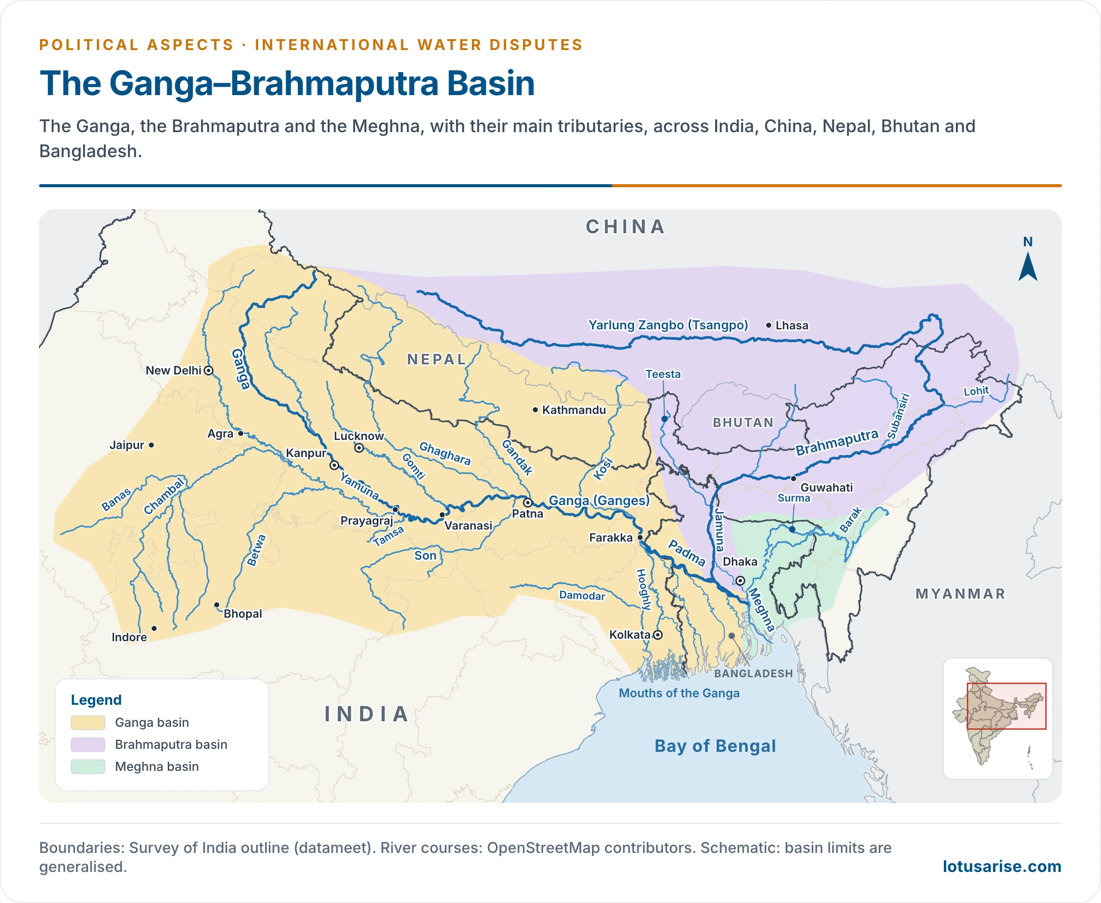
- Upstream position: the Brahmaputra, known as the Yarlung Zangbo (Tsangpo), and the Satluj both rise in Tibet. So do Ganga tributaries such as the Karnali and the Arun, fed by Himalayan glaciers, while the Ganga’s own source at Gangotri lies in Uttarakhand.
- As the upper riparian, China holds an advantage: it can build works that hold back water from flowing downstream.
- Lower riparians: India and Bangladesh both rely on the Brahmaputra’s water for agriculture.
- Trust deficit: China’s past reluctance to give details of its hydropower projects, and its dam and water diversion plans, have left doubts between the two neighbours, despite several memoranda on communication and strategic trust.
- Both India and Bangladesh worry that dams could let Beijing divert or store water in a political crisis.
- Dams on the river:
- Zangmu (510 MW) has been fully running since October 2015, and plans for four more dams in Tibet followed.
- Medog (Motuo): China began the Yarlung Tsangpo hydropower project on 19 July 2025, near the Great Bend, with five cascade stations, a planned capacity of about 60 GW and a cost of about 1.2 trillion yuan.
- India fears sudden releases and changed seasonal flows. An Assam government estimate puts China’s share of the river’s total flow at only 30–35%, the rest being generated in India.
- India’s response: the proposed Siang Upper Multipurpose Project, an 11,200 MW storage dam in Arunachal Pradesh, is intended partly as a buffer. As of October 2026 it is at preliminary feasibility stage, unapproved, and opposed locally over displacement.
- Data sharing:
| Date | Step |
|---|---|
| 2002 | Memorandum on the Brahmaputra: flood-season data (rainfall, water level, discharge) from 1 June to 15 October; transmission began that June |
| 2006 | Expert Level Mechanism on trans-border rivers set up |
| 6 November 2020 | Satluj memorandum lapses |
| 5 June 2023 | Brahmaputra memorandum lapses, after renewals in 2008, 2013 and 2018 |
| January 2025 | Both sides agree to an early meeting of the Mechanism on resuming data |
| April 2025 | The Mechanism meets |
| August 2026 | India tells Parliament that no Brahmaputra data has come since June 2023, and presses for a further meeting and details of upstream projects |
- India also sought additional hydrological stations on the Langqen Zangbo (Satluj) and on the Parlung Zangbo, a Brahmaputra tributary.
- India’s own works: India has built dams and a barrage on the Teesta, a tributary of the Brahmaputra, to use its dry-season flow.
India and Bangladesh
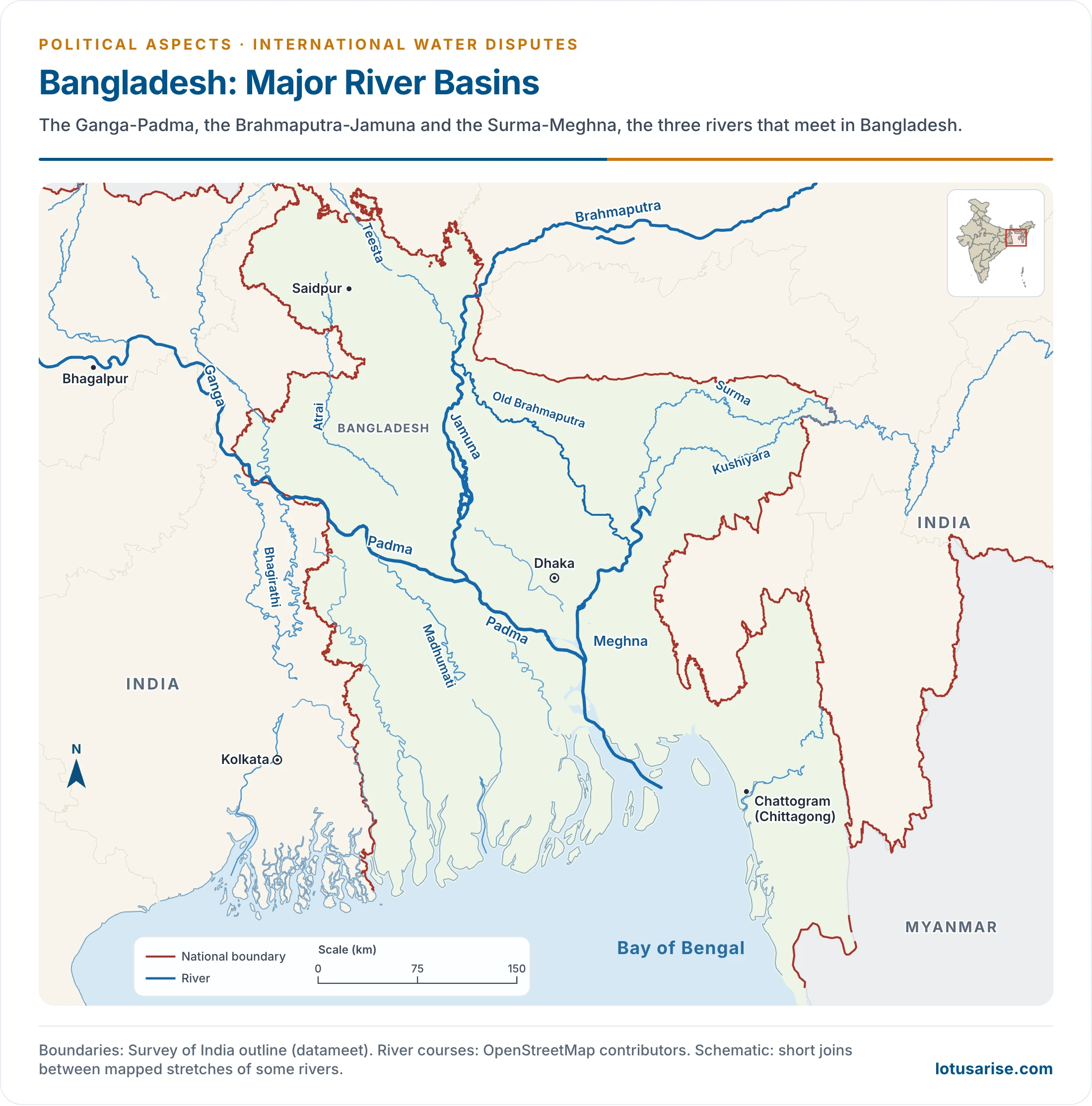
- The two countries share 54 rivers, most of them rising in India or Nepal. An Indo-Bangladesh Joint Rivers Commission has worked since 1972, the year after Bangladesh’s liberation, to maximise joint benefit from these rivers.
- Much of the discord concerns the Farakka Barrage, built on the Ganga about 18 km upstream of the border.
Why the Barrage Was Built
- The Ganga swung away in the 16th century from its old main channel, the Bhagirathi-Hooghly, to the Padma in East Bengal.
- The old course is marked by Hindu pilgrim centres such as Nabadwip, Tribeni and Ganga Sagar, and the Padma has none.
- Other rivers of West Bengal then declined. In 1770 the Damodar changed course in high flood and joined the Bhagirathi-Hooghly about 60 miles further south.
- Until then it had partly made up for what the Ganga no longer sent.
- After the shift, the channel’s upper and middle reaches grew shallower and came to depend on tides from the sea.
- The barrage was to divert water and flush silt, to keep the over-silting Calcutta (Kolkata) port navigable.
From 1951 to 1996
| Date | Event |
|---|---|
| 29 October 1951 | Pakistan, then holding East Bengal, raises the scheme with India and protests |
| 1952 | India replies that the project is only under preliminary study, and the fears hypothetical |
| 1961 | Construction starts |
| 1970 | Barrage completed |
| 1971–72 | Liberation of Bangladesh, a breakthrough for talks; Joint Rivers Commission formed |
| 21 April to 31 May 1975 | Short-term arrangement for the barrage’s commissioning: 11,000–16,000 cusecs to India, 44,000–49,000 to Bangladesh |
| After August 1975 | Sheikh Mujibur Rahman is killed; India does not extend the accord and withdraws unilaterally |
| 26 November 1976 | UN General Assembly consensus statement urges talks |
| 5 November 1977 | Five-year agreement, under the Janata government of Morarji Desai |
| October 1982 | Memorandum of understanding for 1983 and 1984 |
| 1985 | No sharing in the absence of any understanding |
| November 1985 | Memorandum for 1986 to 1988 |
| 1986 | Rajiv Gandhi agrees to bring in Nepal, and the talks fail |
| 1989 onward | No instrument in force |
| 12 December 1996 | Ganga Water Treaty signed by H. D. Deve Gowda and Sheikh Hasina |
- The early argument: Pakistan held that heavy diversion would harm East Pakistan’s agriculture, fisheries and ecology.
- India said that in the January–May lean season, with flows as low as 55,000 cusecs, it needed 40,000 cusecs to flush the port. Pakistan objected that this left too little, and its efforts to take the dispute to international forums made no headway.
- The 1977 agreement: it shared flow at Farakka from 1 January to 31 May, by ten-day periods, on a schedule based on 75% availability in the record of 1948–73.
- In the leanest period, 21–30 April, it gave Bangladesh 34,500 cusecs of 55,000, with India keeping 20,500.
- If flow rose or fell, it was shared in the same proportion. Bangladesh was protected with a floor of 80% of its scheduled share, which in that period comes to 27,600 cusecs.
- It ran for five years, extendable by mutual consent.
- The quarrel over augmenting the flow:
- India’s plan: a link canal from the Brahmaputra through Bangladeshi territory. Bangladesh called it “legally unjustifiable, technically impracticable” and economically and ecologically disastrous.
- Bangladesh’s plan: upstream dams in Nepal, to add water and generate power. India rejected this as outside strict bilateralism, and for years would not bring Nepal, a major Ganga basin country, into a comprehensive agreement.
- Critics of the canal said it relied on a geomorphologically unstable river with poor lean-season flow, left both ends under Indian control, and only moved water without adding any. They judged the Nepal storages stronger on economic, ecological and political grounds.
- The Joint Rivers Commission found no long-term solution, and the Brahmaputra–Ganga link remains a proposal.
The Ganga Water Treaty, 1996
- Structure: a Preamble, 12 Articles and two Annexures, in force for 30 years from signature, renewable by mutual consent.
| Availability at Farakka (cusecs) | India’s share | Bangladesh’s share |
|---|---|---|
| 70,000 or less | 50% | 50% |
| 70,000 to 75,000 | Balance of flow | 35,000 cusecs |
| 75,000 or more | 40,000 cusecs | Balance of flow |
- Guarantee: each country receives a guaranteed 35,000 cusecs in alternate three ten-day periods, between 11 March and 10 May.
- Annexure II works out the formula on average flows of 1949–88:
| Ten-day period | Average flow (cusecs) | India (cusecs) | Bangladesh (cusecs) |
|---|---|---|---|
| 11–20 March | 68,931 | 33,931 | 35,000 |
| 21–31 March | 64,688 | 35,000 | 29,688 |
| 1–10 April | 63,180 | 28,180 | 35,000 |
| 11–20 April | 62,633 | 35,000 | 27,633 |
| 21–30 April | 60,992 | 25,992 | 35,000 |
| 1–10 May | 67,351 | 35,000 | 32,351 |
- Other safeguards:
- Below 50,000 cusecs in any ten-day period, the two governments consult at once on emergency adjustments.
- A Joint Committee observes flows at Farakka and Hardinge Bridge, and unresolved differences go to the Joint Rivers Commission.
- Without agreed adjustments after a review, India releases at least 90% of Bangladesh’s share.
- Some sections in both countries objected to the treaty, but the two governments have worked it for three decades.
- Current position:
- Bilateral talks on renewal had not begun when the government replied to Parliament on 1 August 2025. Technical meetings had last been held in March 2025, and West Bengal was being consulted.
- On 30 July 2026, the Standing Committee on External Affairs urged the government to begin talks.
- In August 2026, Bangladesh’s Foreign Minister said a team had been formed and his country awaited India’s response on a new or revised treaty.
- In September and October 2026, the Ministry of External Affairs said such matters belong to the Joint Rivers Commission, with technical meetings continuing.
- Bihar is also demanding a say, citing silting behind the barrage.
Teesta and Other Rivers
- Teesta: the river flows through Sikkim and West Bengal into Bangladesh, and Gazoldoba is the release point.
| Date | Step |
|---|---|
| 1983 | Ad hoc arrangement: India 39%, Bangladesh 36%, 25% unallocated |
| 2011 | Draft 15-year interim deal: India 42.5%, Bangladesh 37.5%; left unsigned after West Bengal’s objection |
| August 2022 | 38th meeting of the Commission ends with no breakthrough |
| June 2026 | Bangladesh and China agree on technical help for a Teesta master plan |
| August 2026 | Bangladesh’s Water Resources Minister presses for an agreement while seeking to keep ties with India friendly |
- The proposed master plan lies close to the Siliguri Corridor, which has drawn Indian concern.
- Kushiyara: the text of an interim sharing memorandum was settled at the same 2022 meeting.
- Flood data: India passes forecasting data on the Ganga, Teesta, Brahmaputra and Barak to Bangladesh in the monsoon.
India and Pakistan
Before the Treaty
- The Indus system has been in dispute since the partition of 1947, which left headworks in India and much of the canal land in Pakistan.
- On 1 April 1948, East Punjab shut off water to West Punjab along the main branches of the Upper Bari Doab and Dipalpur canals.
- The Inter-Dominion Agreement of 4 May 1948 restored supply, though disputes continued.
The Indus Waters Treaty, 1960
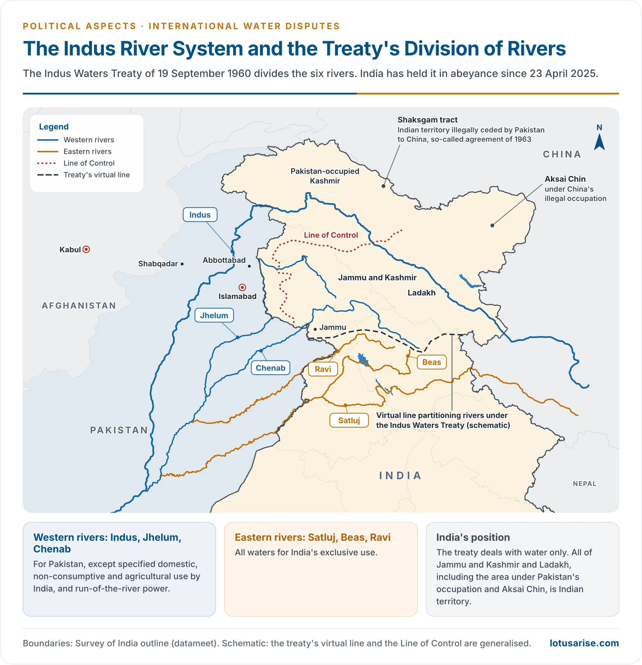
- The Indus Waters Treaty was signed on 19 September 1960, brokered by the World Bank, as a comprehensive plan for the rivers of the system. It was long hailed as a satisfactory settlement of the largest river basin dispute.
| Group | Rivers | Allocation |
|---|---|---|
| Eastern rivers | Satluj, Beas, Ravi | All waters for India’s exclusive use |
| Western rivers | Indus, Jhelum, Chenab | For Pakistan, except specified domestic, non-consumptive and agricultural use by India, and run-of-the-river power |
- Overall, India can use only about 20% of the system’s total discharge.
- Permanent Indus Commission: the treaty created a Commissioner for Indus Waters in each country, representing its government on all treaty matters and acting as the regular channel of communication.
- The treaty deals with water only. All of Jammu and Kashmir and Ladakh, including the area under Pakistan’s occupation and Aksai Chin, is Indian territory.
Projects in Dispute
- The treaty limits what Jammu and Kashmir, now a Union Territory, can divert or store, and Pakistan has objected to many proposals for using its rivers:
- Baglihar (450 MW, Chenab): notified in 1992. Neutral Expert Raymond Lafitte gave his decision on 12 February 2007, accepting the gated spillways and requiring some design changes.
- Kishanganga (330 MW): the Court of Arbitration’s final award of 20 December 2013 allowed the project, with a minimum flow of 9 cumecs downstream. The plant was commissioned in May 2018.
- Tulbul navigation project: a barrage on the Jhelum at the mouth of Wular Lake, suspended in 1987 after Pakistan’s objection. India treats it as a navigation work that does not block the river’s flow.
- Ratle (850 MW, Chenab): with Kishanganga, the subject of the present proceedings.
The Debate Over Withdrawal
- Criticism of the treaty: it gives Pakistan the larger flows, and denies India the main benefit of being upper riparian.
- The case for withdrawal, argued over many years, rested on Pakistan’s involvement in cross-border terrorism.
- The cautions then raised:
- Other countries have gone back on long-standing agreements, but ending a treaty is a grave step, and it would not itself stop flows until India builds storage reservoirs and decides how to use the water.
- India’s record as a responsible state could suffer, and Nepal and Bangladesh, with their own river treaties, could hold it against India, especially for a treaty with World Bank backing.
- An overland gas pipeline across Pakistan would lose credibility. If a treaty then 42 years old could be ended by one party, such a deal would have little sanctity.
Status Since April 2025
- Abeyance: on 23 April 2025, after the Pahalgam terror attack, India announced that the treaty “will be held in abeyance” until Pakistan credibly and irrevocably abjures its support for cross-border terrorism.
- India had already been seeking review and modification under Article XII(3).
- Two legal tracks began with the Kishanganga and Ratle designs:
| Track | Requested by | Steps |
|---|---|---|
| Neutral Expert | India, 2016 | Held competent in January 2025; a modelling exercise was set on 25 May 2026 to run to March 2027, and a final decision is expected around July 2027 |
| Court of Arbitration | Pakistan | India holds it was constituted in breach of the treaty and has never appeared before it |
- Awards of the Court:
- 27 June 2025: a Supplemental Award held that abeyance did not limit its competence.
- 15 May 2026: a Supplemental Award on maximum pondage. India’s Ministry of External Affairs called it null and void the next day.
- 31 August 2026: an award found the treaty “fully in force”, rejected the grounds for suspension, and barred concreting of the Ratle dam wall above set levels until 90 days after the Neutral Expert’s decision.
- India’s response: the Ministry “categorically rejects” the award as coming from a so-called Court with no jurisdiction. India’s position is that the treaty stays in abeyance.
- India has stopped taking part in the Neutral Expert process as well since the abeyance.
India and Nepal
- The Mahakali forms the boundary on major stretches, and the Kosi and Gandak flow into Bihar through works on or near the border. Tanakpur and Pancheshwar have been the main points of contention.
| Agreement | Date | Content |
|---|---|---|
| Sarada Barrage letters | 1920 | Barrage on the Mahakali, with some water for Nepal |
| Kosi Agreement | 25 April 1954; revised 19 December 1966 | Barrage and canals on the Kosi |
| Gandak Agreement | 4 December 1959 | Irrigation and power on the Gandak |
| Mahakali Treaty | 12 February 1996; in force June 1997 | Sarada, Tanakpur and Pancheshwar |
The Mahakali Treaty
- Sarada Barrage: Nepal may draw 1,000 cusecs in the wet season and 150 cusecs in the dry season. India keeps at least 350 cusecs flowing below the barrage for the river’s ecosystem.
- Tanakpur (120 MW): the barrage stands on the Mahakali, known in India as the Sarda or Sharda, and part of its eastern afflux bund at Jimuwa lies on about 2.9 hectares of Nepalese land.
- In return, Nepal gets 1,000 cusecs in the wet season, 300 cusecs in the dry season, and 70 million units of energy a year free of cost. Figures of 50 million units and 150 cusecs appear in older accounts.
- Nepal keeps sovereignty over this land. India also supplies 350 cusecs to irrigate the Dodhara–Chandani area of Nepal.
- Pancheshwar Multipurpose Project: the treaty’s centrepiece, on the boundary stretch of the river.
- Both countries have equal entitlement to the waters, without prejudice to existing uses.
- It provides for power stations of equal capacity on each bank, with energy shared equally and costs borne in proportion to benefit.
- Reports give a 315 m dam and about 5,040 MW, with some putting the capacity at 4,800 MW.
- Why it has stayed contentious: Indian accounts have called the terms favourable to Nepal, while the sharing of Tanakpur’s water and power stayed a sticking point in relations.
- The Pancheshwar report has missed every deadline since the six months the two sides set themselves in 1996. Irrigation and flood-control benefits, and the quantum of water rights, remain open.
- In August 2026, reports said the Joint Committee on Water Resources would take up the project in September, after a gap of about four years.
- The river’s upper reach also bears on Nepal’s claim over Kalapani, which India rejects.
Other Cooperation
- Joint Committee on Water Resources: the umbrella body over all the committees and groups on water.
- Sapta Kosi High Dam and Sun Kosi Storage-cum-Diversion: the two sides agreed on joint field study and a detailed report. In September 2022 they agreed on further study of the high dam.
- Standing Committee on Inundation Problems: working since 1986, it finds problem areas and solutions for flooding caused by works on border rivers.
- Joint Committee on Kosi and Gandak Projects: at its 11th meeting, on 30 April and 1 May 2026 in Kathmandu, Nepal agreed to clear encroachments from project areas, including a 35 km stretch of the Western Kosi Main Canal. India agreed to look into waterlogging in the canal commands.
India and Bhutan
- Hydropower cooperation goes back more than five decades, to a 1974 agreement for Chukha. The first projects were modest, and the scale has grown since.
| Project | Capacity (MW) | Commissioned |
|---|---|---|
| Chukha | 336 | 1986–88 |
| Kurichu (Kurichhu) | 60 | 2001–02 |
| Tala | 1,020 | 2006–07 |
| Mangdechhu | 720 | 2019 |
| Punatsangchhu-II | 1,020 | Inaugurated 11 November 2025 |
| Punatsangchhu-I | 1,200 | Dam concreting restarted, April 2026 |
- Potential: Bhutan’s hydropower potential has long been put at about 30,000 MW, of which over 23,000 MW is reckoned technically and economically viable.
- Targets: the 2006 hydropower agreement, often described with a 35-year power purchase term, set a goal of 5,000 MW by 2020.
- A decision of 2008, formalised by protocol in March 2009, raised this to 10,000 MW. The target was missed: the five finished projects total about 3,150 MW.
- Newer modes: joint ventures with Indian participation are building Khorlochhu (600 MW), Dorjilung (1,125 MW) and Wangchhu (570 MW). The Sankosh project was under discussion in June 2026.
- Trade: Bhutan exports surplus power to India in the wet months and imports in the lean season. An older commitment to buy 4,000 MW was seen as strengthening the national grid and serving the north-east.
- Water data: a Joint Expert Team, working since 1979, oversees a network of 35 hydro-meteorological stations in Bhutan. India uses its data for flood forecasting.
- Regional plan: Bhutan agreed to a sub-regional plan to divert 12,000 cusecs from the Sankosh to the Teesta, and on to Farakka, shared with India and Bangladesh.
- Concerns: people in Bhutan have raised objections to the long-run effects of these projects.
- Should Bhutan ever build storage projects, issues with India could sharpen.
- Its own internal challenge is access to water.
The Wider Picture
- Everyday water questions get too little attention. Sharing and use are folded into larger security or border concerns, or taken up only when disaster strikes, yet they shape the prosperity and security of countries.
- This transboundary issue is integral to national development policy, and it calls for closer analysis by the parties to these agreements.
- Other conflicts over water run alongside: big dam controversies, local disputes, rural and urban supply, and pollution. An agreed approach to equitable distribution, and an end to its misuse, are the common needs.
- Regional bodies and open debate on these agreements, with understanding among stakeholders, can help resolve these issues in the light of experience.
- Near-term hydro-diplomacy could begin with less sensitive areas:
- Managing floods by sharing forecasting data.
- Collaborating on navigation, electricity generation and water quality.
- If these work, such informal cooperation might make countries readier for an official multilateral forum. Despite some limitations, it could build trust, settle grievances and manage shared waterways.
Previous Year Questions
2016Map item: Farakka Barrage