

- A glacier is a mass of ice moving under its own weight. It forms where snow builds up faster than it is lost through ablation, over many years, and it is a sensitive indicator of a changing climate.
- India’s glaciers lie almost wholly in the Himalaya and the Karakoram, and they feed the Indus, Ganga and Brahmaputra river systems.
- Some of the longest glaciers outside the polar regions are in the Karakoram. Siachen in Ladakh is the longest under India’s control, and Gangotri is the source stream of the Ganga.
Glaciers in General
Basics
- Glaciers are generally found in snowfields.
- Glaciers and ice sheets are the largest store of fresh water, and cover around 10% of the land surface of the earth.
- Share of earth’s water: an older figure gives 2.1% in glaciers and 97.2% in the oceans and inland seas. Later estimates are nearer 1.7% in ice and snow and 96.5% in the oceans.
- Conditions for glacier formation:
- Mean annual temperature is close to the freezing point.
- Winter precipitation gives significant accumulation of snow.
- Temperatures in the rest of the year do not remove all of the previous winter’s snow.
Mountain Glaciers and Ice Sheets
- By topography and location, glaciers are mountain (alpine) glaciers or continental glaciers (ice sheets). Types of glaciers, by form and temperature, take this further.
| Basis | Alpine or mountain glacier | Ice sheet or continental glacier |
|---|---|---|
| Where | High mountains, on mountainsides | Antarctica and Greenland |
| Movement | Higher to lower altitude, down the valleys | Outward in all directions from a broad dome |
| Effect | Deepens the valley by removing soil, dirt and other material | Covers valleys, plains and mountains under a thick blanket |
- Geographical location: about 91% of the world’s glacier ice is in Antarctica and 8% in Greenland. The remaining mountain glaciers make up a small share, though they matter most to people.
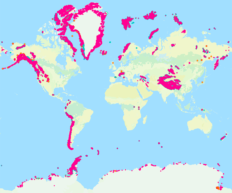
Glaciers of India
How Much Ice
- Number: classical estimates give about 15,000 glaciers in the Himalaya, lying between the two syntaxial bends. The Geological Survey of India counts 9,575 glaciers in India.
- Area: the Himalaya covers about five lakh sq km, against nearly 32 lakh sq km for India. Classical estimates put about 33,000 sq km of it under snow, with roughly half, near 16,000 sq km, in the Karakoram.
- Past ice: the Pleistocene ice cover was far greater than today’s, and old glacial landscapes record it.
The Snow Line
- The snow line marks where perpetual snow begins. Its height shifts along the Himalaya with latitude, the amount of precipitation and local relief.
- Glacier snouts descend to about 3,965 m around Kanchenjunga, 3,660 m in Kumaon and Lahaul and 2,500 m in Kashmir.
- T. D. La Touche gave two reasons: latitude climbs from 28°N in Sikkim to 36°N in the far north-west, and the eastern ranges rise straight from the plains.
- In the west, total precipitation is lower, but it falls as snow. In the Great Himalaya, the line is lower on the steeper, wetter southern slopes.
- Chogo Lungma in the Karakoram ends at about 2,075 m, the lowest recorded.
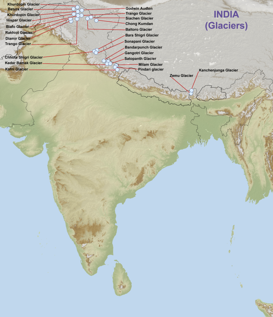
- On this map, Khurdopin and Trango each appear twice.
List of Important Glaciers
- Lengths are in km, with the older figure in brackets where it differs.
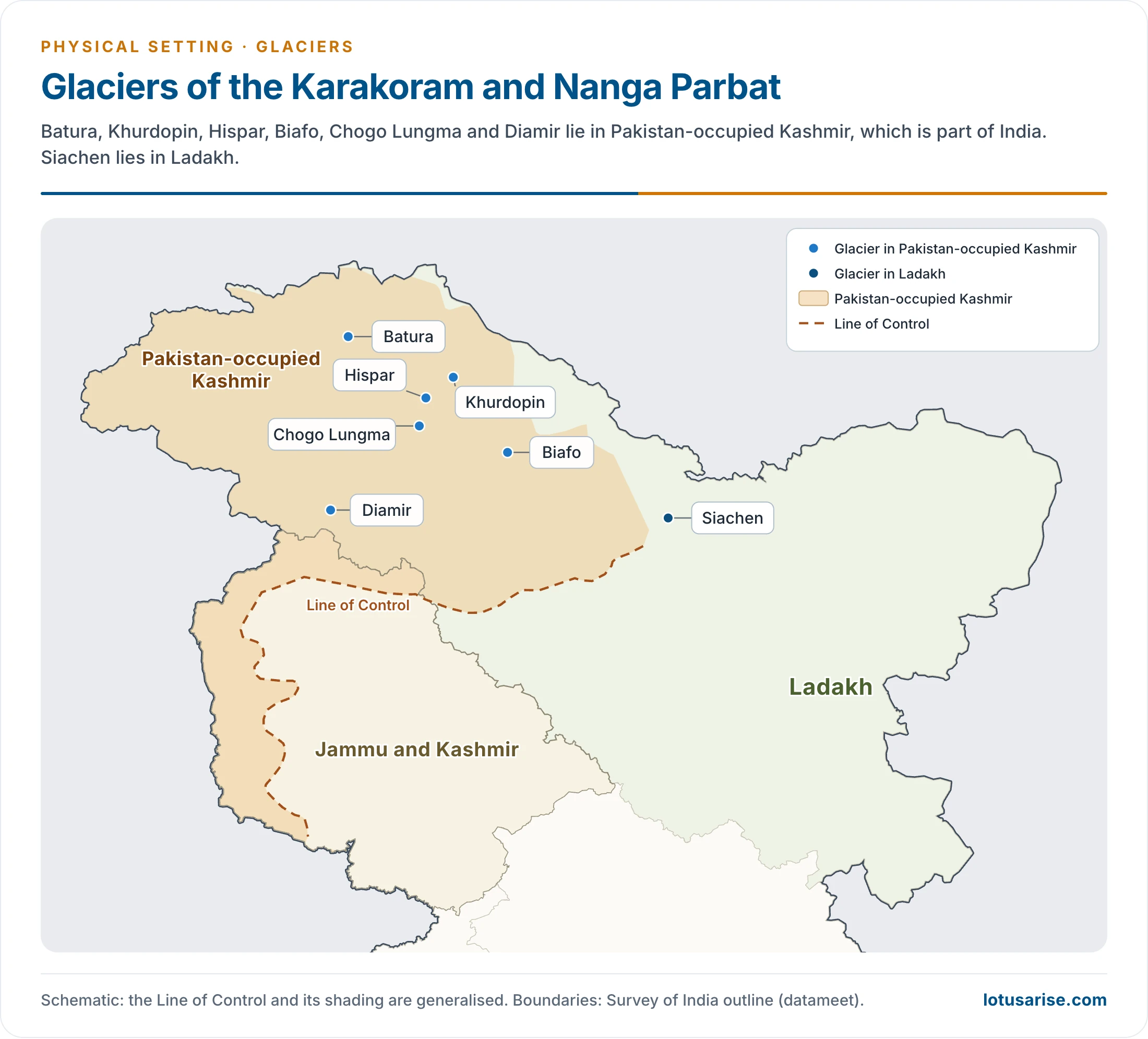
- Glaciers placed in Gilgit–Baltistan or the Hunza–Nagar area lie in Pakistan-occupied Kashmir, which is part of India.
| Name | State or area | Range or location | Length (km) |
|---|---|---|---|
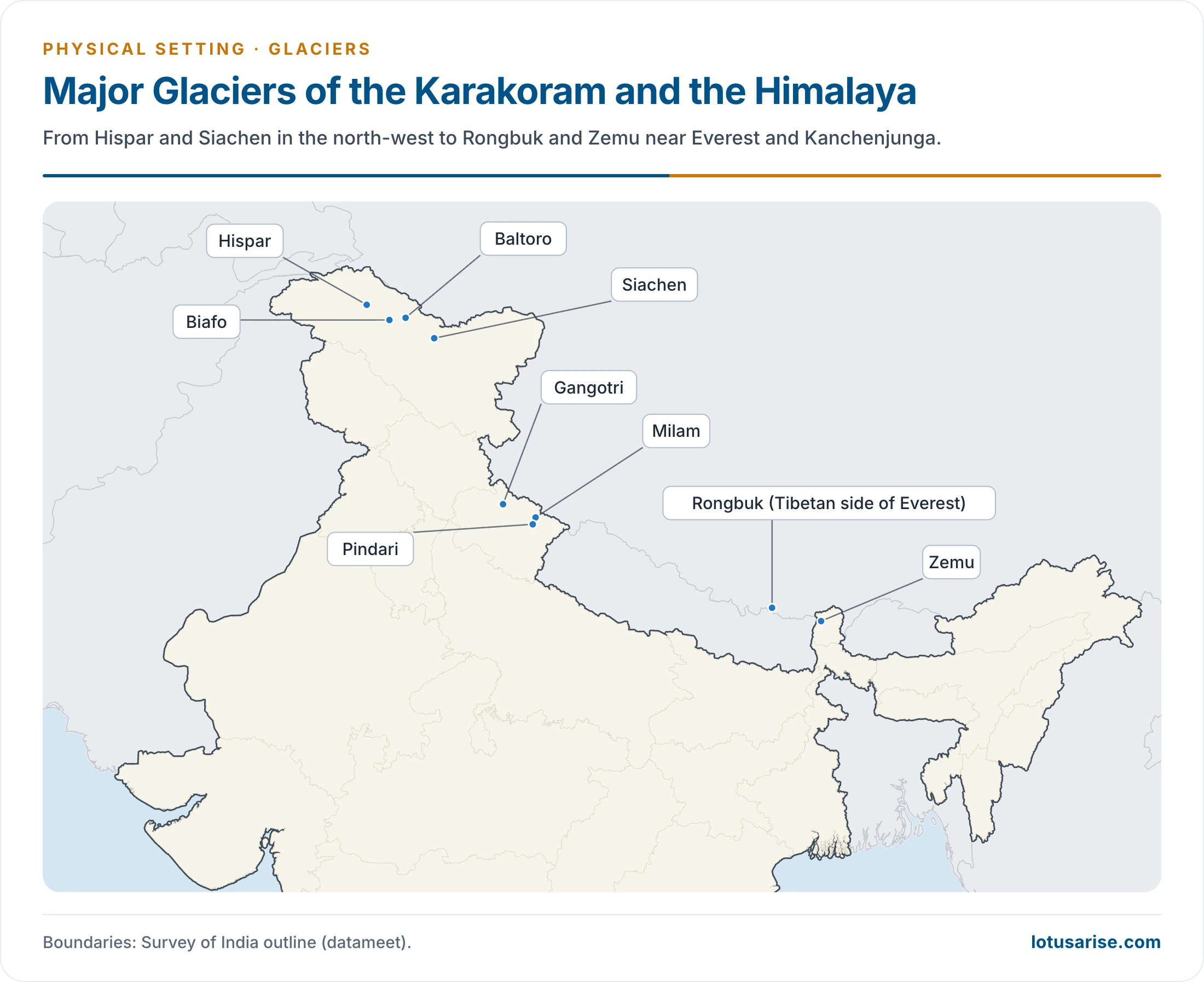
| Siachen | Ladakh | Karakoram, Nubra valley | 76 (75) |
| Batura | Pakistan-occupied Kashmir | Karakoram, upper Hunza | 57 (58) |
| Khurdopin (Khurdopla) | Pakistan-occupied Kashmir | Karakoram, Shimshal valley | 47 |
| Hispar | Pakistan-occupied Kashmir | Karakoram, Hunza side | 49 (62) |
| Biafo | Pakistan-occupied Kashmir | Karakoram, Braldu side | 67 (59) |
| Baltoro | Pakistan-occupied Kashmir | Karakoram, Braldu valley | 63 (58; 65) |
| Chogo Lungma | Pakistan-occupied Kashmir | Karakoram, Shigar side | 50 |
| Godwin-Austen | Pakistan-occupied Kashmir | Karakoram, below K2 | 30 |
| Trango | Pakistan-occupied Kashmir | Karakoram, Baltoro Muztagh | |
| Chong Kumdan | Ladakh | Karakoram, Shyok valley | 21 |
| Diamir | Pakistan-occupied Kashmir | Nanga Parbat massif | 11 |
| Rakhiot | Pakistan-occupied Kashmir | Nanga Parbat massif | 15 |
| Bara Shigri | Himachal Pradesh | Pir Panjal, Chandra valley | About 28 (10–20) |
| Chhota Shigri | Himachal Pradesh | Pir Panjal, Chandra valley | |
| Sonapani | Himachal Pradesh | Pir Panjal, Chandra valley | 15 |
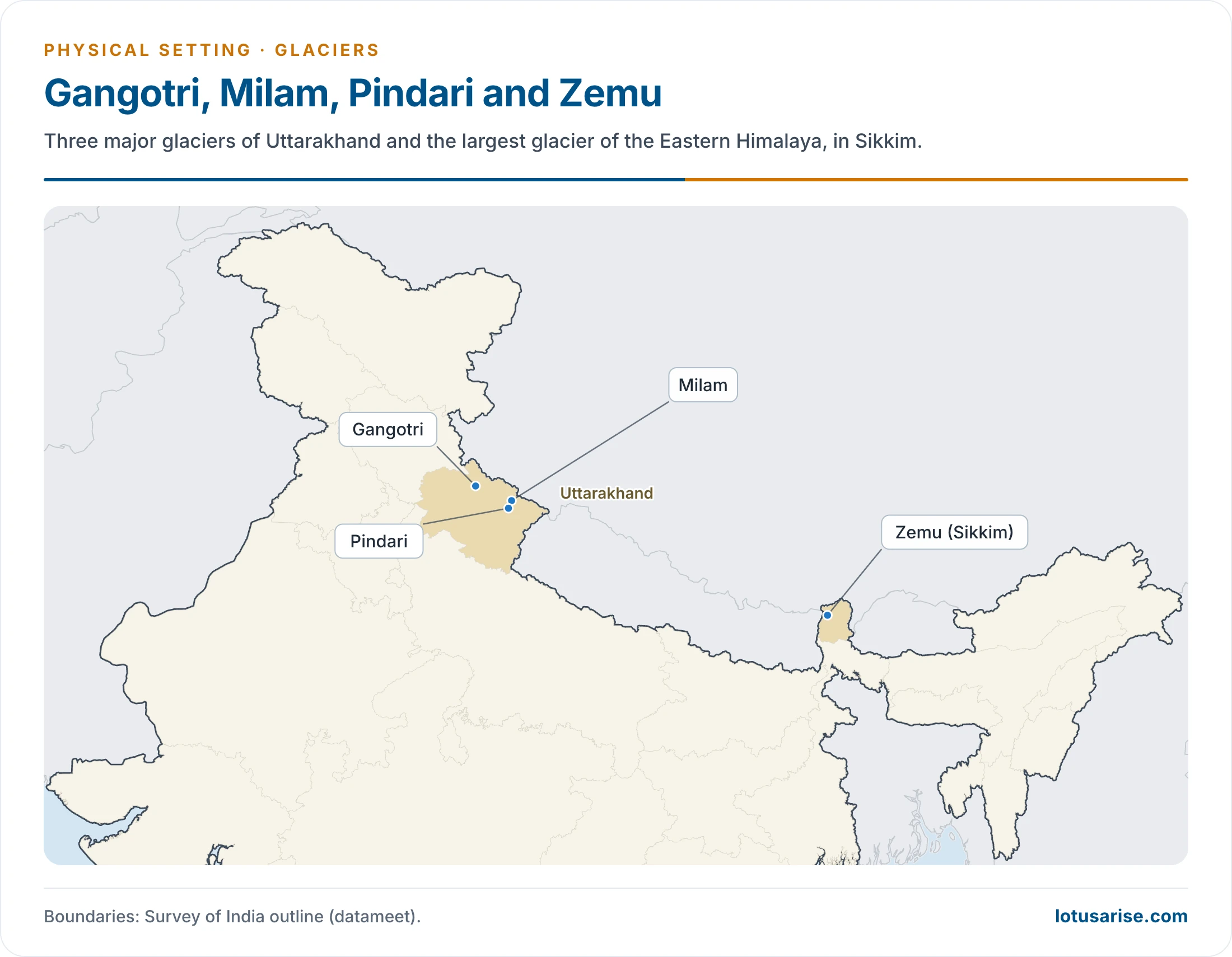
| Gangotri | Uttarakhand (Uttarkashi) | Garhwal Himalaya | 30 |
| Bandarpunch | Uttarakhand | Western edge of the high Himalaya | |
| Milam | Uttarakhand (Pithoragarh) | Kumaon, near Trishul side | 20 |
| Pindari | Uttarakhand | Upper Kumaon, near Nanda Devi | |
| Kafni | Uttarakhand | Kumaon–Garhwal | |
| Kalabaland | Uttarakhand | Kumaon–Garhwal | |
| Kedar Bamak | Uttarakhand | Kumaon–Garhwal | |
| Meola | Uttarakhand | Kumaon–Garhwal | |
| Namik | Uttarakhand | Kumaon–Garhwal | |
| Panchchuli | Uttarakhand | Kumaon–Garhwal | |
| Ralam | Uttarakhand | Kumaon–Garhwal | |
| Sona | Uttarakhand | Kumaon–Garhwal | |
| Satopanth | Uttarakhand | Garhwal, near Badrinath | 16 |
| Sunderdhunga | Uttarakhand | Kumaon–Garhwal | |
| Dokriani | Uttarakhand | Garhwal | |
| Chorabari | Uttarakhand | Garhwal, source of the Mandakini | |
| Zemu | Sikkim | Eastern Himalaya, base of Kanchenjunga | 26 (25) |
| Kanchenjunga | Sikkim | Eastern Himalaya | 21 |
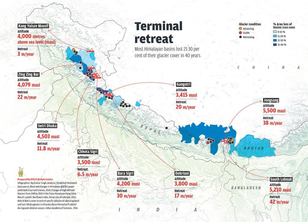
- This graphic’s retreat figures come from studies up to 2016, and its basin losses cover 1960–2000.
Karakoram Range
- Mountain ice reaches its greatest extent here. The southern flank carries glaciers that rank among the longest anywhere beyond the polar lands.
- Ranks: Fedchenko (77 km) in the Pamirs is the longest outside the polar regions, and Siachen (about 76 km) is second. Older accounts reversed the order, giving 75 km and 74 km.
- Other glaciers of the range:
- Shyok valley: Rimo (40 km), Chong Kumdan, Aktash (8 km) and Kichik Kumdan (11 km).
- Shaksgam side: Urdok, Kyagar and Gasherbrum.
- Shimshal valley: Virjerab (40 km), Mombil Yaz (32 km) and Yazghil (31 km).
- Hunza side: Pasu (25 km) and Ghulkin (18 km).
Pir Panjal and Nun Kun
- The Pir Panjal holds less ice than the Karakoram, in shorter and scarcer glaciers.
- Bara Shigri in the Chandra valley is the largest in Himachal Pradesh, at about 28 km, and its melt feeds the Chandra. Sonapani, also in the Chandra valley of Lahaul and Spiti, is about 15 km long, and earlier lists gave it first place.
- Nun Kun massif: Gangri (13 km).
- Nanga Parbat massif: small and fast-moving glaciers on steep slopes, such as Chungphar, Rakhiot, Buzhi and Tashan.
Kumaon–Garhwal Region
- Gangotri (30 km) leads this region, and gives the Ganga its source stream.
- Milam (20 km) comes next. Nine tributary glaciers unite to form it, and its meltwater feeds the Gori Ganga.
- Others include Mana and Bhagirath Kharak (18 km each) and Satopanth (16 km).
- Garhwal region: it lies in the Himalaya, with Tibet to the north, the Kumaon region to the east, Uttar Pradesh to the south and Himachal Pradesh to the north-west.
- It includes Chamoli, Dehradun, Haridwar, Pauri Garhwal, Rudraprayag, Tehri Garhwal and Uttarkashi districts.
Central Nepal and the Kanchenjunga–Everest Region
- Central Nepal lies between Cho Oyu and Dhaulagiri. Its glaciers are small and little known: Yepokangara (13.5 km), Lidanda and Chhuling (11 km each, Manaslu), and Mayondi (11 km).
- Zemu and Kanchenjunga are the major glaciers of the Sikkim section further east, and are often listed with this stretch.
- Near Everest: Rongbuk, Khumbu (20 km), Kangshung (19 km) and Barun (15 km).
Notes on Major Glaciers
Gangotri Glacier
- The largest glacier in Uttarakhand, in Uttarkashi district. It is the source of the Ganga by way of the Bhagirathi.
- It starts on the northern slope of the Chaukhamba range of peaks in the Garhwal Himalaya.
- It is not a single valley glacier, but a union of several glaciers, and is 2–4 km wide.
- Black carbon on Gangotri:
- The Wadia Institute of Himalayan Geology, an autonomous institute under the Department of Science and Technology, runs a Chirbasa station at 3,600 m and a Bhojbasa station at 3,800 m.
- They track black carbon on key Himalayan glaciers, and Gangotri is of special interest because it feeds the Ganga.
- Its 2016 readings at Chirbasa ran from 0.01 µg/m³ in winter to 4.62 µg/m³ in summer, a rise of about 400 times. Older reports spoke of a doubling over a few years.
- The main causes are agricultural burning and forest fires in the summer, with tourist traffic adding to it. Black carbon absorbs light, and so can speed melting.
Siachen Glacier
- It lies in the Karakoram, in the Nubra valley, in Ladakh, and is about 2–8 km wide. It ranks second in length among glaciers beyond the polar lands.
- Its chief feeders are Lolofond and Teram Shehr.
- Position: it has been held by India since Operation Meghdoot (13 April 1984). Pakistan disputes this, and the matter turns on the unmarked line beyond point NJ9842.
- It is the world’s highest battlefield, and its melt feeds the Nubra.
Fedchenko Glacier
- A long, narrow glacier in the Yazgulem Range of the Pamir Mountains, in north-central Gorno-Badakhshan province, Tajikistan.
- It is 77 km long, the longest outside the polar regions, ranking above Siachen.
- Older accounts allot it 450 sq km of the north-western Pamir, with ice nearly 550 m deep. Later figures give over 700 sq km and up to 1,000 m.
Hispar and Biafo
- Hispar is often called the third largest of the Karakoram. Its valley drains to the Hunza River, and Kunyong or Lak (24 km) is a large feeder.
- It joins Biafo at Hispar La (5,128 m), forming a glacial system of about 100 km, the longest outside the polar regions on that measure. Older accounts describe the two as occupying about 65 sq km of the Braldoh valley.
- Biafo lies between Hispar and Baltoro, on the Braldoh (Braldu) side. Older lists place it fourth in the Karakoram at 59 km. It is now put at 67 km, with a basin of 853 sq km.
Baltoro Glacier
- About 63 km long (65 km in older accounts), in the Karakoram west of Siachen, around K2 and the other giants of Baltistan.
- Its melt gives rise to the Shigar River, a tributary of the Indus. The Godwin-Austen Glacier joins it at Concordia.
Pindari Glacier
- South-east of Nanda Devi and Nanda Kot, in the upper Kumaon Himalaya of north-east Uttarakhand.
- It is the source of the Pindar River, and the approach offers a 90 km round-trip trek.
Rongbuk Glacier
- On the Tibetan side of Mount Everest, flowing north with the East and West Rongbuk tributaries.
- Older accounts give 52 km and call it the largest outside the Karakoram. The main glacier is now measured at about 22.4 km.
- The famous Rongbuk Monastery stands at the northern end of the Rongbuk Valley.
- The Englishman George Mallory explored it in 1921, while looking for possible routes to the summit of Everest.
Zemu Glacier
- The largest glacier of the Eastern Himalaya, about 26 km long (25 km in older accounts), at the base of Kanchenjunga in Sikkim.
- Moving east, it heads the Zemu River. Its ice is about 1 km across and 180 m deep.
- It is regarded as one of the possible sources of the Teesta, and several branches from the high peaks merge into it.
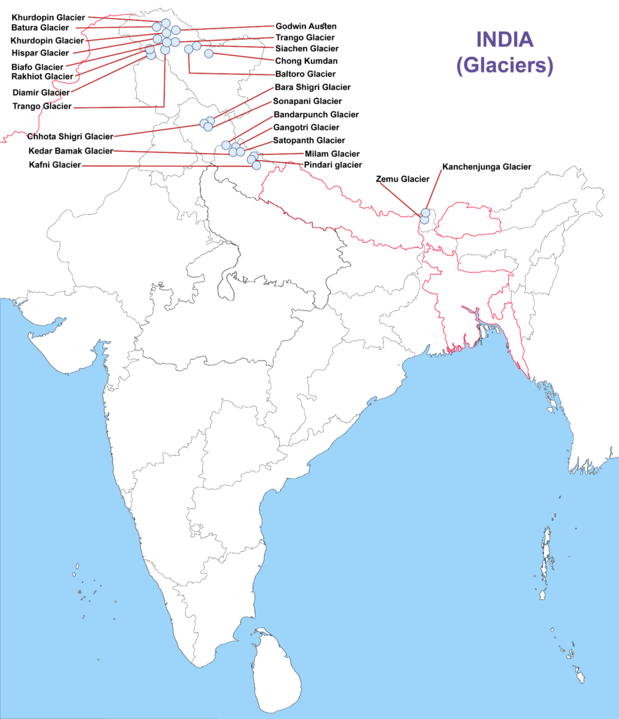
- On this map too, Khurdopin and Trango each appear twice.
Glaciers Under Change
- Retreat: in 2016, the government told the Lok Sabha that most glaciers, including Gangotri, were melting at varying rates of 5–20 m a year. Long-term figures for Gangotri put it near 20 m a year.
- Latest monitoring: a Rajya Sabha statement of 2024 reported 1.68–18 m a year for seven Geological Survey of India glaciers in the Shyok, Nubra, South Chenab and Beas basins. The mean for the Hindu Kush Himalaya in an official reply is 14.9 ± 15.1 m a year.
- Regional contrast: official statements say Karakoram glaciers are stable, while those feeding the Ganga and Brahmaputra basins melt faster. The Karakoram’s stable or slightly gaining ice, the Karakoram Anomaly, is not expected to last.
- Monitoring network: the National Centre for Polar and Ocean Research has watched six glaciers in the Chandra basin since 2013.
- Glacial lakes:
- The South Lhonak lake in Sikkim burst on 3–4 October 2023, and destroyed the Chungthang dam of Teesta III.
- The National Disaster Management Authority programme covers about 195 lakes listed as at risk, with a Rs 150 crore mitigation outlay.
- The Central Water Commission monitors 2,843 glacial lakes and water bodies over 10 hectares each June to October (May 2026).
- Link to mountain hazards: Dharali, Uttarkashi (5 August 2025) shows how contested such events are. Early accounts blamed a cloudburst, while later reports point to landslide-dammed lakes or ice high in the catchment.


Fedchenko(Tajikistan) is the longest glacier in the World’s Non-Polar areas.
Siachen Glacier is the 2nd longest glacier in the World’s Non-Polar area.
..
Thank You
Thank you so much for such quality content..keep up the good work!
Thank you
Best website for geography