

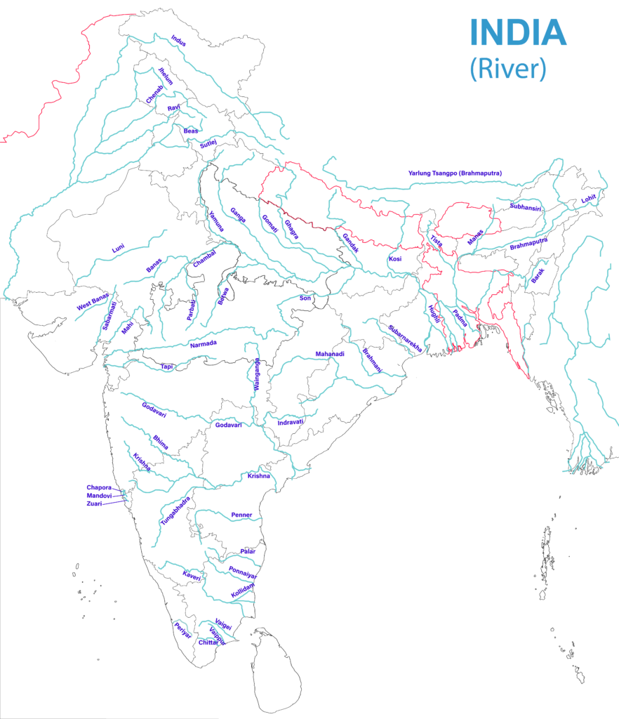
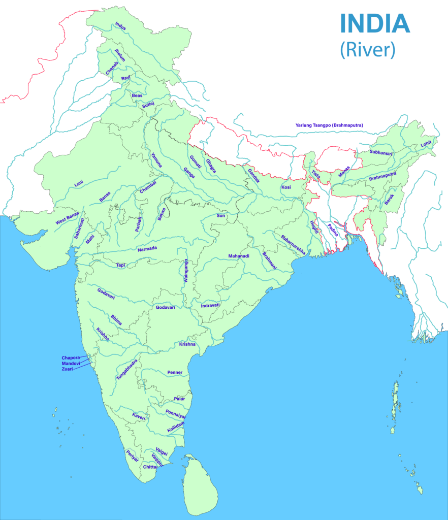
- This is an atlas list of India’s rivers, arranged basin by basin, so that each can be placed on a map by its source, course, tributaries and mouth.
- The rivers fall into two groups by origin: Himalayan rivers, mostly perennial, and Peninsular rivers, mostly rain-fed. The wider account is in the Indian river system.
- About 77% of the drainage area faces the Bay of Bengal and about 23% the Arabian Sea. A few rivers, such as the Luni and the Ghaggar, never reach the sea.
- Jammu and Kashmir, Ladakh and Arunachal Pradesh are integral parts of India. Places in the areas under Pakistan’s occupation are named on that basis.
| River | Source | Length (km) | Basin in India (sq km) | Mouth |
|---|---|---|---|---|
| Indus | Near Lake Manasarovar, Tibet | 2,880 (3,600 in a 2011 study) | 3,21,289 | Arabian Sea |
| Ganga | Gangotri Glacier | 2,525 | 8,61,404 | Bay of Bengal |
| Yamuna | Yamunotri Glacier | 1,376 | 3,66,223 | Ganga, Prayagraj |
| Brahmaputra | Chemayungdung Glacier, Tibet | 2,900 (3,848 in a 2011 study) | 2,58,008 | Bay of Bengal, with the Ganga |
| Godavari | Trimbakeshwar, Nashik | 1,465 | 3,12,812 | Bay of Bengal |
| Krishna | Near Mahabaleshwar | 1,400 | 2,58,948 | Bay of Bengal |
| Mahanadi | Near Sihawa, Dhamtari | 851 (older 857) | 1,41,589 | Bay of Bengal |
| Cauvery | Talakaveri, Kodagu | 800 | 81,155 | Bay of Bengal |
| Narmada | Amarkantak | 1,312 (older 1,310) | 98,796 | Gulf of Khambhat |
| Tapi | Near Multai, Betul | 724 (older 730) | 65,145 | Gulf of Khambhat |
Himalayan Rivers
Indus System
- Indus: a 2,880 km river that rises in Tibet near Lake Manasarovar (Mansarovar) and ends in the Arabian Sea beyond Karachi.
- In India it flows between the Ladakh and Zaskar ranges, forming a gorge, and Leh stands by it.
- Its five great eastern tributaries gather in the Panjnad (Panchnad) and meet it near Mithankot in Pakistan.
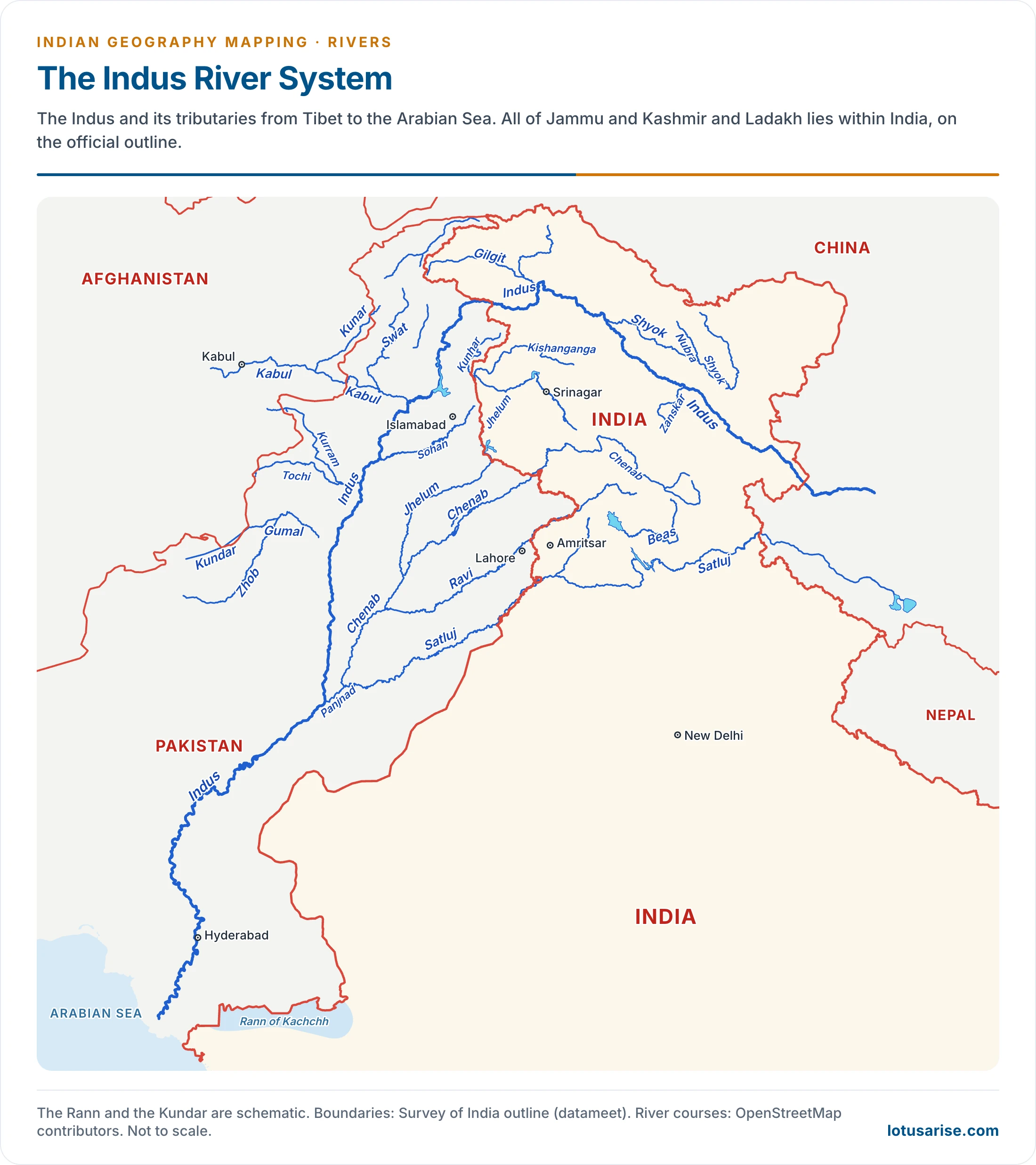
- Shyok: a right-bank tributary of the Indus, about 550 km long, rising from the Rimo Glacier beside the Depsang Plains. It flows along the Karakoram Range.
- It marks the south-eastern limit of the Karakoram.
- It is fed by several glaciers, including the Siachen Glacier, through the Nubra.
- It lies wholly within Ladakh, including the Baltistan stretch under Pakistan’s occupation.
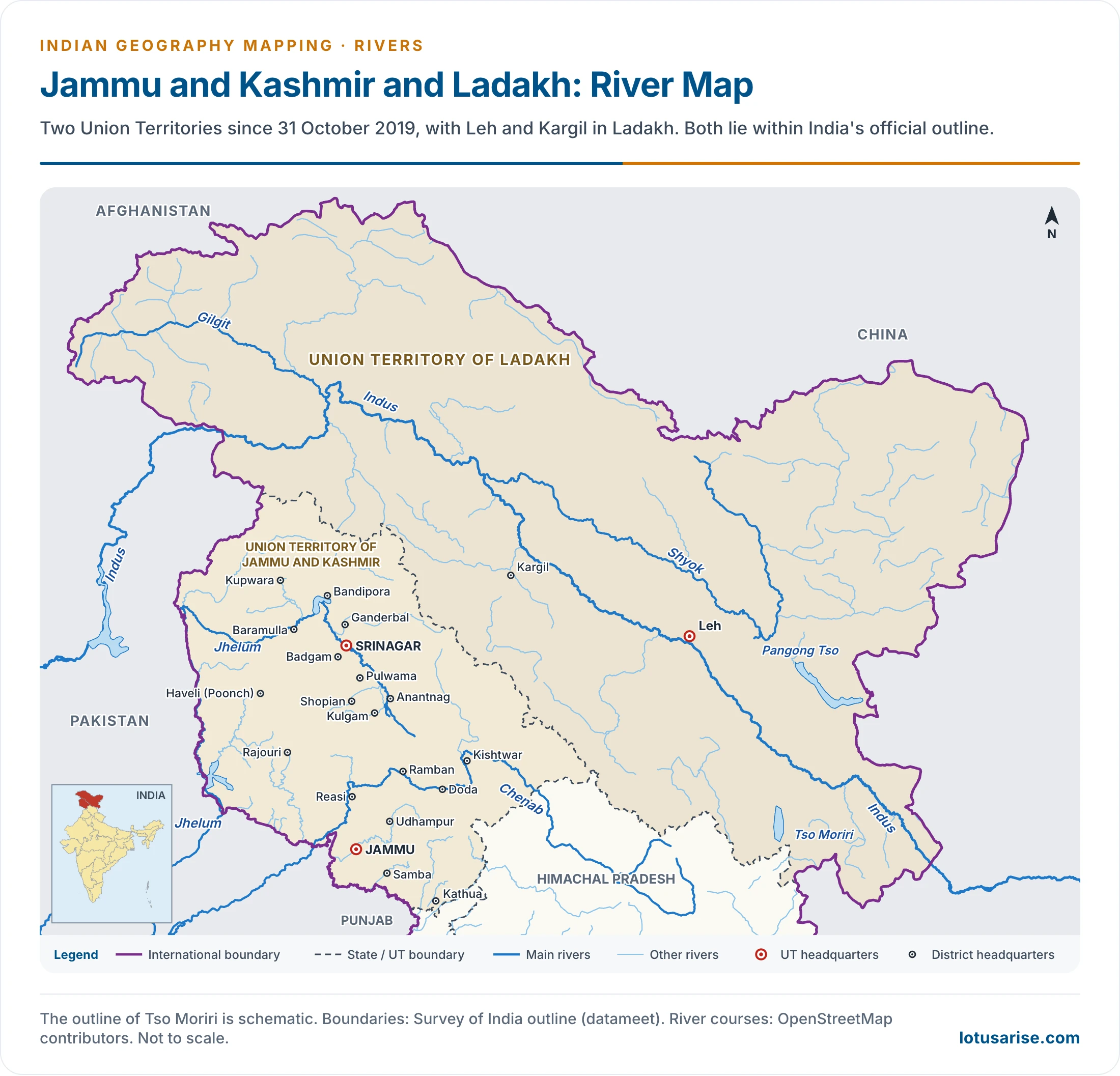
- Zaskar (Zanskar): a left-bank tributary, flowing between the Zaskar Range (south) and the Ladakh Range (north).
- It meets the Indus at Nimmu, just west of Leh, and lies wholly within Ladakh.
- Gilgit: a right-bank tributary in the Gilgit area of Ladakh, under Pakistan’s occupation.
- It rises in the north-west corner of India and meets the Indus close to where the main river bends south-west.
- Gilgit city stands on it.
- Jhelum: rises at Verinag, at the foot of the Pir Panjal in south-eastern Kashmir, and is the main river of the Kashmir Valley, passing through Wular Lake.
- Srinagar stands on it. Tributaries: Kishanganga, Lidar, Sind and Pohru.
- For about 170 km below Muzaffarabad it marks the boundary between Jammu and Kashmir and Pakistan, the adjoining Indian territory being under Pakistan’s occupation.
- Chenab: rises near the Bara Lacha Pass as two headstreams, the Chandra and Bhaga, on either side of the pass.
- Together they run along the Pangi Valley, with the Pir Panjal alongside.
- It joins the Satluj to form the Panjnad, which reaches the Indus near Mithankot.
- Towns: Doda, Kishtwar, Ramban. Projects: Salal, Baglihar, Dul Hasti, with Ratle under construction.
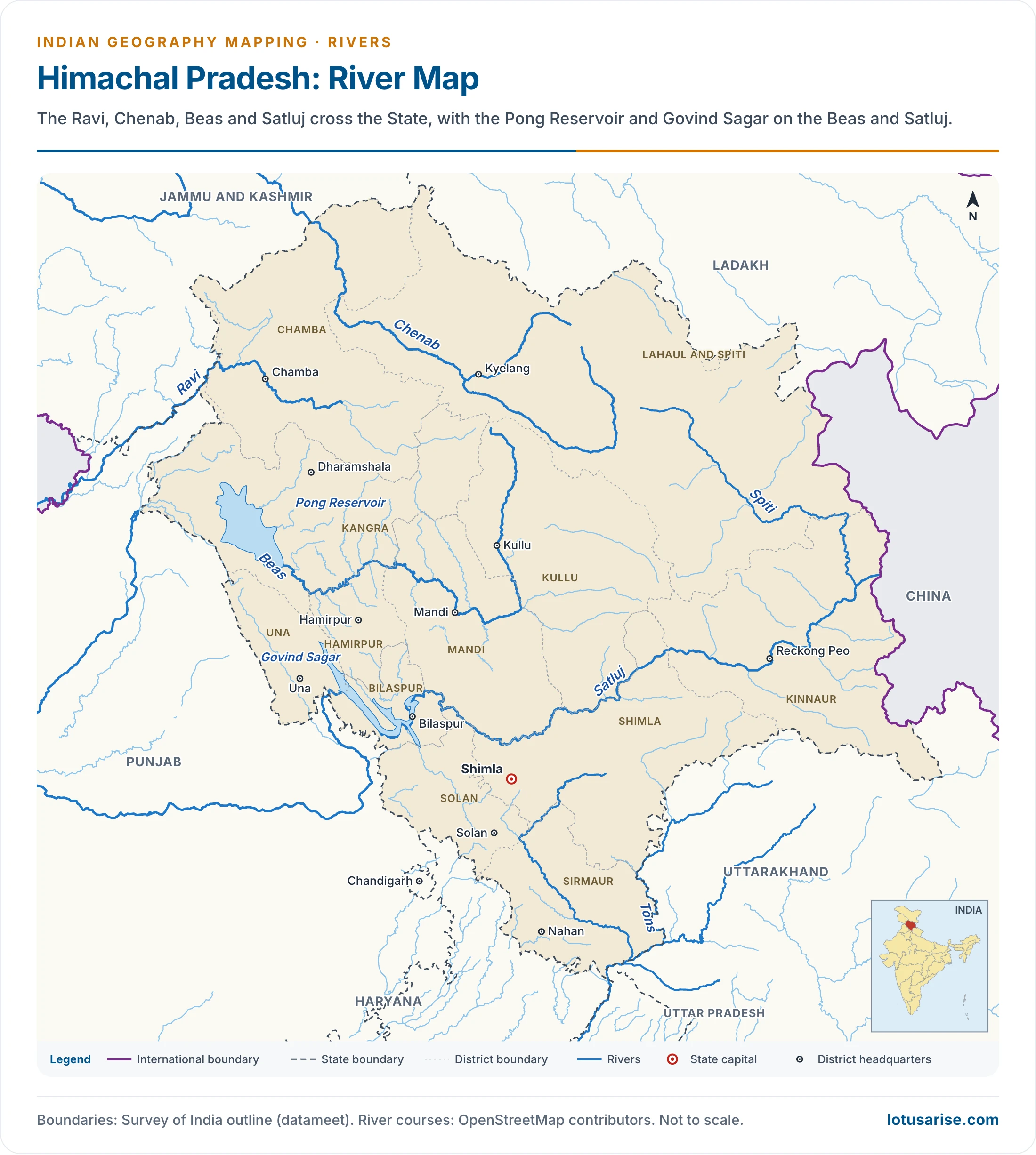
- Ravi: rises in the Kullu hills near the Rohtang Pass, Himachal Pradesh, and flows between the Pir Panjal and the Dhauladhar.
- It cuts a deep gorge in the Dhauladhar. Towns: Chamba, Kathua.
- It forms the Punjab–Jammu and Kashmir boundary, then the India–Pakistan boundary.
- Beas: rises near the Rohtang Pass and meets the Satluj at Harike near Kapurthala.
- It lies wholly in India, with the Pong Reservoir in Himachal Pradesh.
- It cuts a deep gorge in the Dhauladhar.
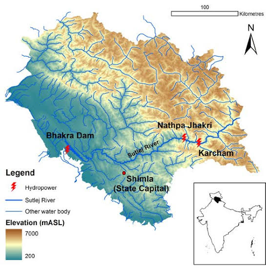
- Satluj: the southernmost major tributary of the Indus, rising from Rakas Lake in Tibet and entering India through the Shipki La.
- Projects: Nathpa Jhakri, Bhakra–Nangal. Tributaries: Beas, Spiti, with the Parechhu reaching it through the Spiti.
- Spiti: a right-bank tributary of the Satluj, whose headstreams rise at the base of the Kunzum Range, north-east of the Rohtang Pass.
- It lies wholly in the north-eastern corner of Himachal Pradesh. Tributaries: Parechhu, Rohtang, Surahi, Hanze and others.
- It merges with the Satluj in Kinnaur, at Khab near Namgia.
- Summer melt raises its flow and makes it dangerous.
- Parechhu (Pare Chu): rises near the Parang La, close to Tso Moriri, flows through Tibet, re-enters India at Kaurik and joins the Spiti at Sumdo.
- It swells dangerously in summer and is partly frozen in winter.
- Tons (Yamuna tributary): rises from the Bandarpunch glacier, in the Yamunotri group, and flows through western Uttarakhand.
- The old NH-94, now NH-134, reaches Yamunotri through the neighbouring Yamuna valley.
Ganga System: Headstreams and Himalayan Tributaries
- Bhagirathi: the headstream of the Ganga, rising from the Gangotri Glacier and meeting the Alaknanda at Devprayag.
- Towns: Uttarkashi, Tehri. Projects: Tehri, Koteshwar.
- Alaknanda: the first major headstream, lying wholly in Uttarakhand.
- It begins at the Satopanth and Bhagirath Kharak glaciers. Its Dhauliganga feeder comes down from the Niti Pass on the border with Tibet.
- It meets the Bhagirathi at Devprayag. Tributaries: Pindar, Mandakini.
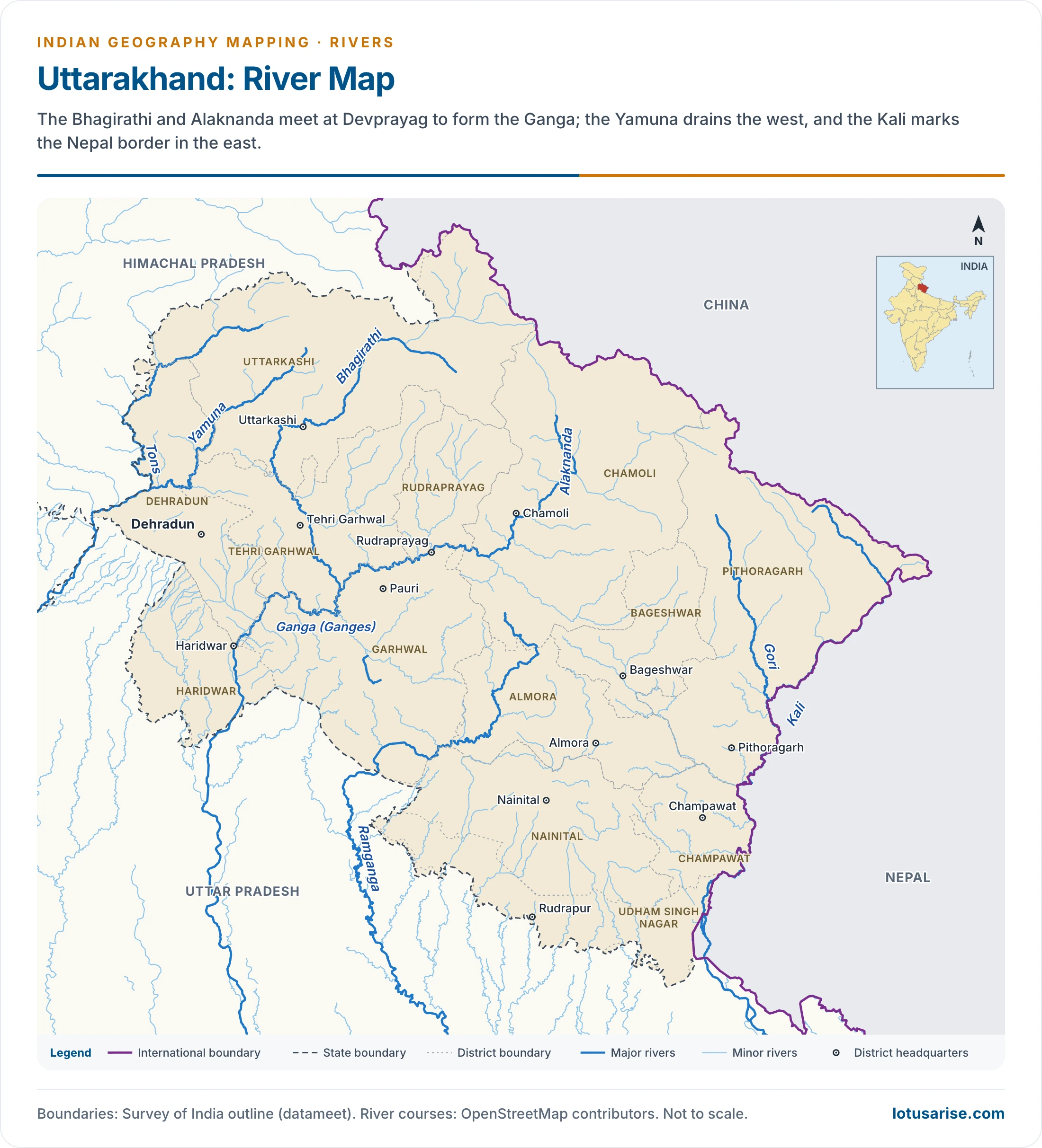
- Pindar: the chief tributary of the Alaknanda, wholly in Uttarakhand, rising from the Pindar Glacier near Nanda Devi. It joins at Karnaprayag.
- Kali–Sarda: a major tributary of the Ghaghara, rising near Kalapani, close to the Lipulekh Pass, in Pithoragarh district, south of the Rakas Lake region of Tibet.
- It is the natural boundary between India and Nepal for most of its mountain course.
- It is the Kali or Mahakali in the hills and the Sarda or Chauka on the plains.
- Its plains course runs through the Dudhwa Tiger Reserve tract.
- Karnali–Ghaghara: rises near Gurla Mandhata, south of Manasarovar in Tibet, and is the Karnali in western Nepal.
- Tributaries: Sarda, Sarju, Rapti.
- It meets the Ganga a few kilometres below Chhapra in Bihar, and forms part of the Uttar Pradesh–Bihar boundary.
- Ganga: the largest and longest river within India, rising from the Gangotri Glacier as the Bhagirathi and draining into the Bay of Bengal.
- It takes the name Ganga from Devprayag and enters the plain at Haridwar.
- It is the Padma in Bangladesh. It is revered as India’s holiest river, and was declared the National River on 4 November 2008.
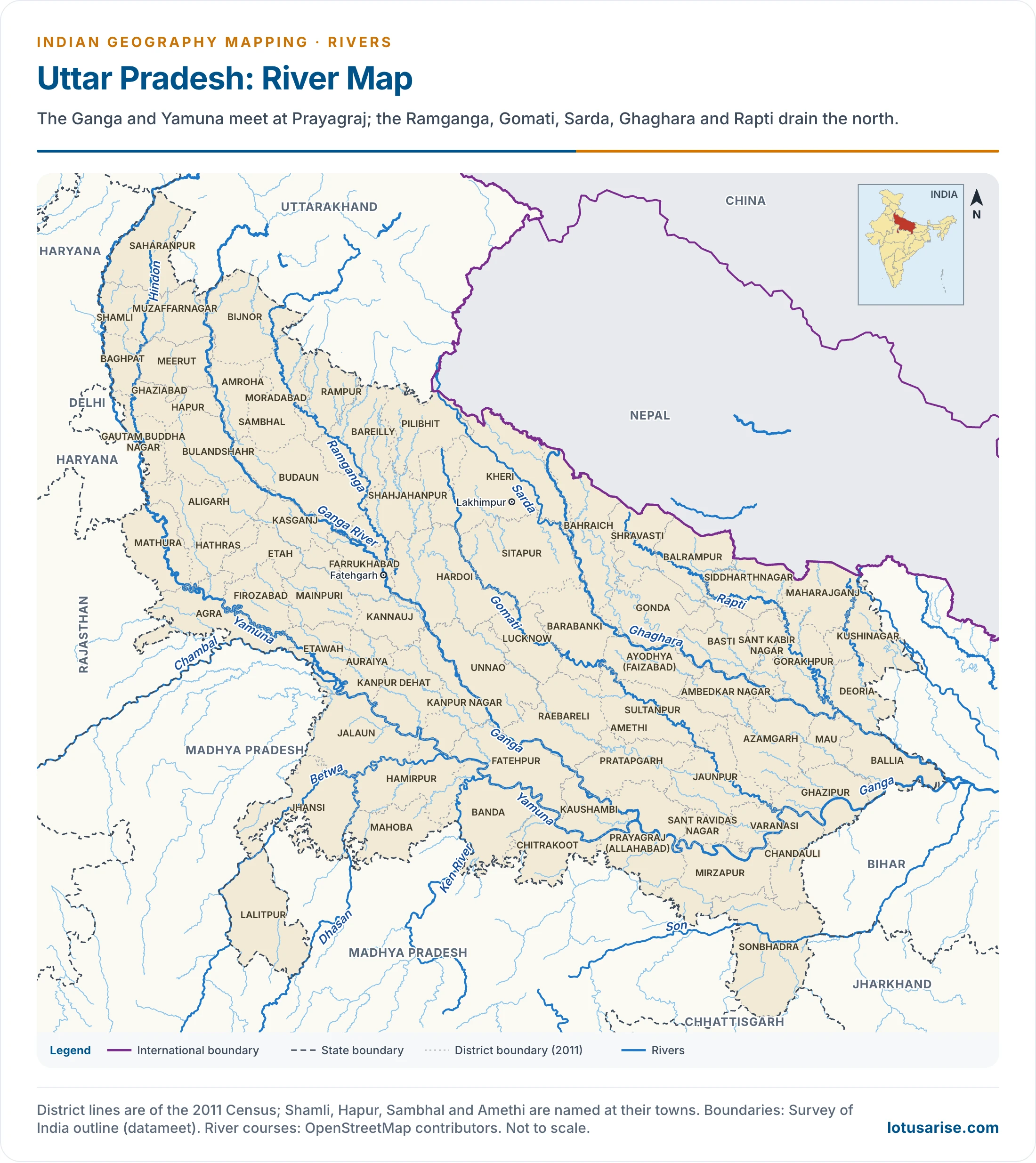
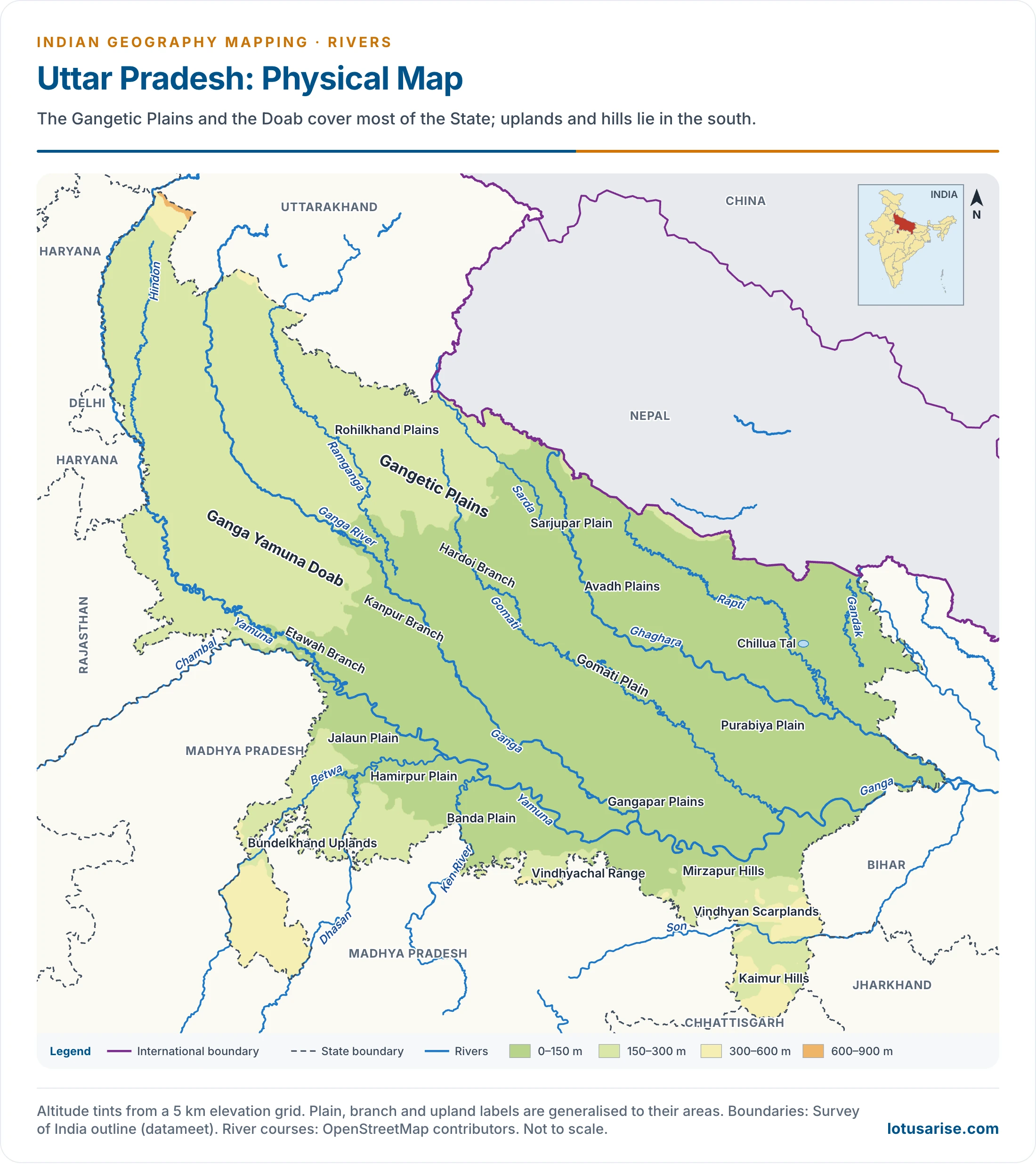
- Ramganga: a tributary of the Ganga, lying between the Gomati (east) and the Ganga (west).
- Its head lies in Garhwal, Uttarakhand, and its mouth near Kannauj. Town: Moradabad.
- Gomati: rises in Pilibhit district, Uttar Pradesh, and joins the Ganga below Sarnath, in Ghazipur district.
- It irrigates the Avadh Plain. City: Lucknow.
- Sarju (Sarayu): a small river of Uttar Pradesh, with Ayodhya on its bank.
- The name is used sometimes for the lower Ghaghara and sometimes for a tributary of it.
- Rapti: a tributary of the Ghaghara, rising in Nepal and joining below Gorakhpur.
- Tributary: Burhi Rapti. Towns: Shravasti, Gorakhpur.
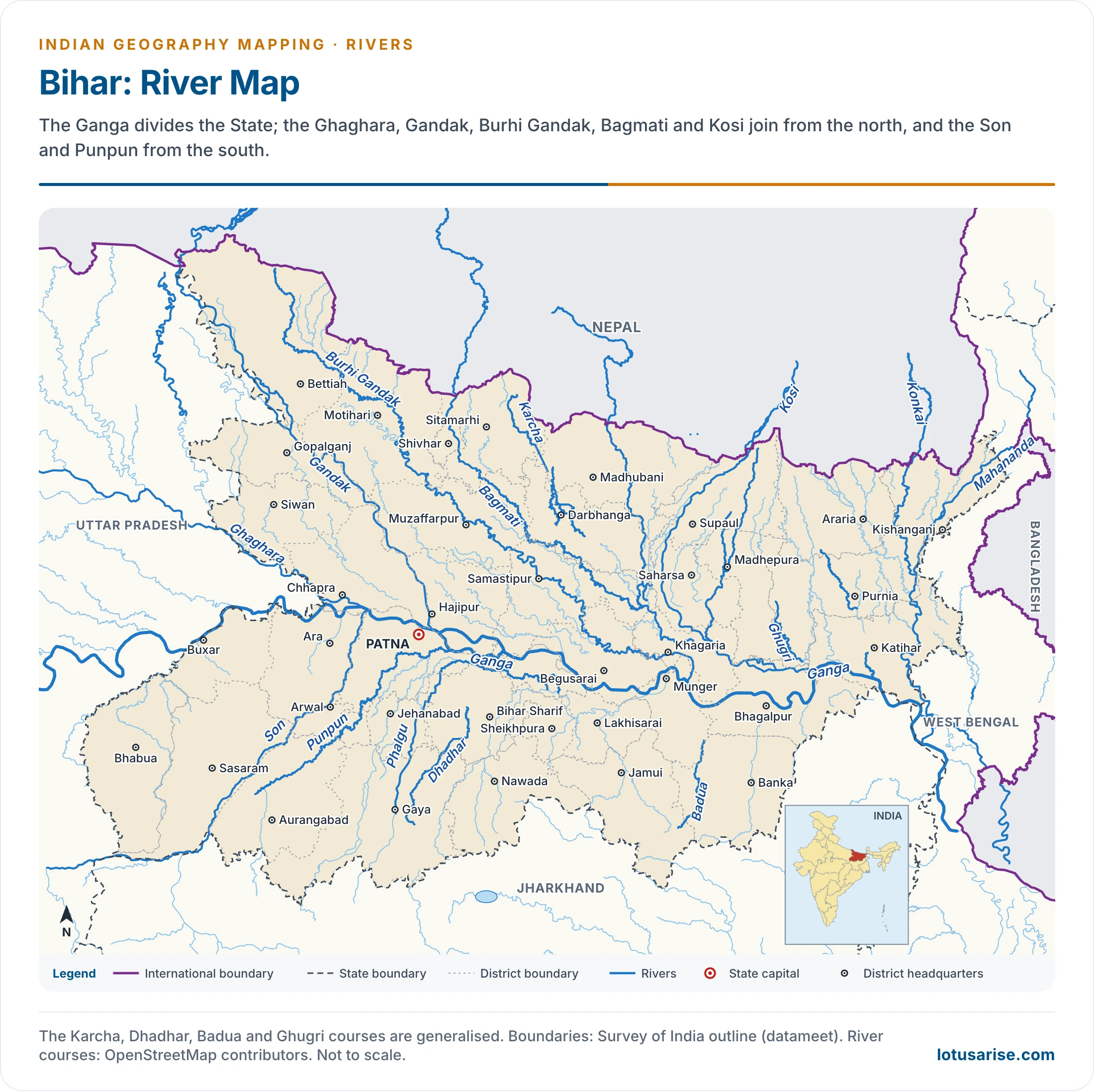
- Gandak: rises near the Tibet–Nepal border, and joins the Ganga opposite Patna, near Hajipur.
- Tributaries: Kali Gandak, Mayangadi, Bari, Trisuli.
- It flows along the Uttar Pradesh–Bihar boundary for part of its course.
- Burhi Gandak: older accounts start it on the western face of the Sumesar Hills, by the Nepal border, in the Valmiki National Park tract. Current sources name Chautarwa Chaur in West Champaran.
- It joins the Ganga opposite Munger (Monghyr). Towns: Motihari, Muzaffarpur, Samastipur.
- Bagmati: a river of Nepal and India, flowing through the Kathmandu Valley, where Kathmandu stands on it, and joining the Kosi in India.
- It cuts the Chobhar Gorge before crossing the Mahabharat Range.
- It is held holy by both Buddhists and Hindus.
- Kosi: made up of seven streams, listed in older accounts as Sut Kosi, Tamba Kosi, Talkha, Doodh Kosi, Botia Kosi, Arun and Tamber.
- The Arun is the main stream, rising north of Gosainthan.
- The Tamor (Tumar), Arun and Sun Kosi unite at Triveni, north of the Mahabharat Range, to form the Kosi.
- Its floods and shifting course earned it the name “Sorrow of Bihar”. A barrage at Hanuman Nagar in Nepal was built to tame it.
- Mahananda: a trans-boundary river of West Bengal, Bihar and Bangladesh, and the last important left-bank tributary of the Ganga before the Brahmaputra.
- It rises in Darjeeling district and flows through the Mahananda Wildlife Sanctuary.
- It is 360 km long, 324 km of it in India.
Brahmaputra System and the North-East
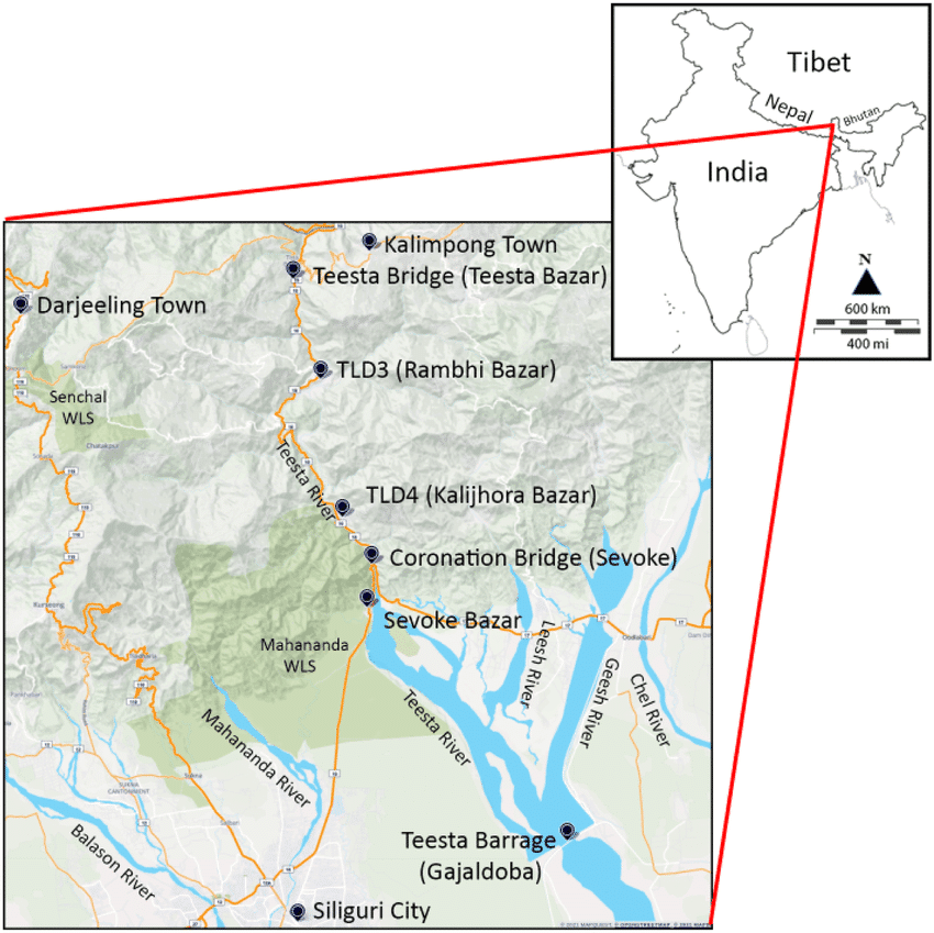
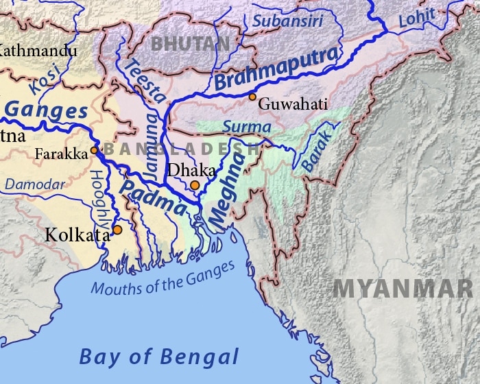
- Teesta (Tista): a major tributary of the Brahmaputra, rising at Tso Lhamo in North Sikkim, close to the Tibet border. It flows through Sikkim and West Bengal and joins the Brahmaputra in Bangladesh.
- It joined the Ganga until a devastating flood of 1787 turned it east.
- It is treated as antecedent, and cuts heavily in the rains.
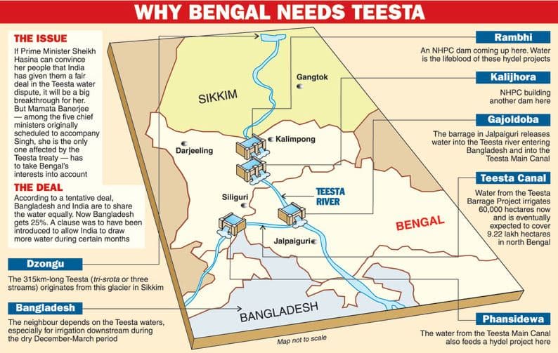
- This graphic dates from the 2011 talks. The deal it describes remains unsigned, and its Rambhi and Kalijhora dams appear on the next map as Teesta Low Dam III and IV.
- Rangit (Rangeet): the main tributary of the Teesta, which is itself Sikkim’s largest river.
- Its turbulent water draws rafters. It forms the Sikkim–West Bengal boundary.
- It has a 60 MW power station.
- Sankosh: rises in Bhutan and joins the Brahmaputra near the India–Bangladesh border. It forms the West Bengal–Assam boundary.
- Raidak: the Wang Chhu of Bhutan, which enters West Bengal in Alipurduar district and flows on to the Brahmaputra in Bangladesh.
- Manas: a right-bank tributary rising in Bhutan, joining the Brahmaputra opposite Goalpara, at Jogighopa.
- It flows through the Manas Biosphere Reserve. The old NH-31, linking Bongaigaon with Nalbari, crosses it.
- Kameng: a right-bank tributary rising in Tawang district of Arunachal Pradesh, near the India–China border, and joining a few kilometres below Tezpur.
- Subansiri: a right-bank tributary rising in Tibet, crossing the India–China border, and joining near Majuli Island.
- It separates the Abor Hills (east) from the Miri and Dafla Hills. Tributary: Kamla.
- The Subansiri Lower Project (2,000 MW) had five of its eight units in operation by 24 October 2026.
- Brahmaputra: rises in the Chemayungdung Glacier of the Kailas Range and joins the Padma in Bangladesh. It is the Tsangpo in Tibet.
- It holds Majuli, long held to be the world’s largest river island.
- It carries the largest volume of water of any river in India, about 527 billion cubic metres a year, and is famous for floods.
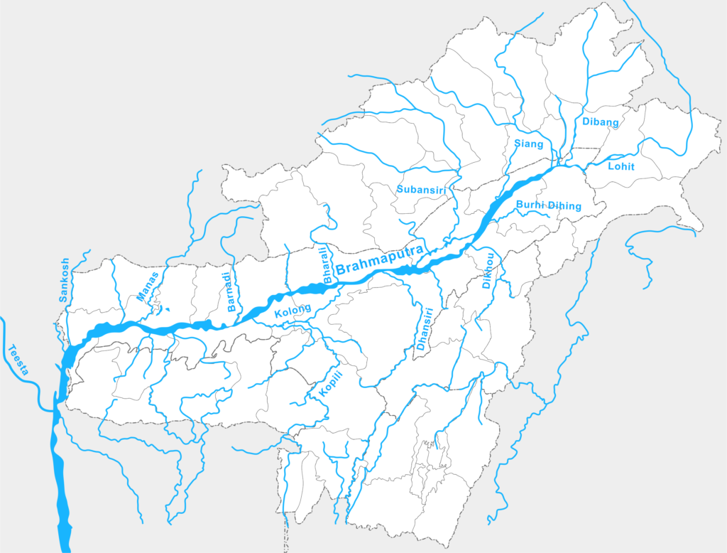
- Dibang: a left-bank tributary in Arunachal Pradesh and Assam, flowing through the Mishmi Hills.
- It forms a trijunction with the Dihang and the Lohit in north-eastern Assam.
- The Dibang Multipurpose Project (2,880 MW) is under construction.
- Lohit: a left-bank tributary in Arunachal Pradesh and Assam, forming the same trijunction in the north-east corner of Assam.
- Tezu and Parshuram Kund lie on it.
- Burhi Dihing: a left-bank tributary rising in the Patkai Bum of Arunachal Pradesh, joining below Dibrugarh, above Majuli. Towns: Naharkatia, Digboi.
- Dikhu: a left-bank tributary rising in the Naga Hills, joining south of Majuli. Town: Sivasagar (Sibsagar).
- Dhansiri: a left-bank tributary rising in the Barail Range of Nagaland, joining just below Majuli.
- It flows east of the Rengma and Mikir Hills, where Kaziranga National Park lies.
- It forms part of the Assam–Nagaland boundary. Towns: Dimapur, Golaghat.
- Barak: the main river of southern Assam and Manipur, rising in the Manipur hills of the Barail Range, in Senapati district, near where Assam, Manipur and Nagaland meet.
- It forms part of the Assam–Manipur boundary. It becomes the Surma and then the Meghna in Bangladesh.
- The proposed Tipaimukh Dam in Manipur has not been built. City: Silchar. The old NH-53, now NH-37, crosses it.
- Manipur: rises in the Manipur Hills, flows south just east of Loktak Lake, and enters Myanmar to join the Myitha, a tributary of the Chindwin.
- It flows between the Laimatol Range and the East Manipur Hills.
- Dhaleshwari (Tlawng): rises in the Mizo Hills and flows north to join the Barak, crossing the Tropic of Cancer.
Rivers of the Plateau Rim and Peninsula
Hugli Tributaries and the Chotanagpur Rivers
- Ajay: the northernmost important tributary of the Hugli, flowing through Bihar, Jharkhand and West Bengal. Shantiniketan lies to its north.
- Damodar: the leading tributary of the Hugli, rising in the Palamau hills of Jharkhand. It is known as the “Sorrow of Bengal”.
- The Damodar Valley Corporation was independent India’s first multipurpose river valley project.
- Tributaries: Barakar, Konar, Jamunia, Ghari and others.
- Rupnarayan: a tributary of the Hugli south of the Damodar, formed in western West Bengal where the Dwarakeswar meets the Silai.
- Town: Bankura, on its upper stream. The old NH-6, now NH-16, crosses it.
- Haldi: the southernmost important tributary of the Hugli, whose upper stream, the Kangsabati, rises in Purulia district. It joins at Haldia. Towns: Medinipur, Haldia.
- Barakar: the main tributary of the Damodar, 225 km long, rising in Hazaribagh district and joining in Bardhaman district, West Bengal.
- Tributaries: Barsoti, Usri. Dams and hydropower: Tilaiya, Maithon.
Yamuna and Son Systems
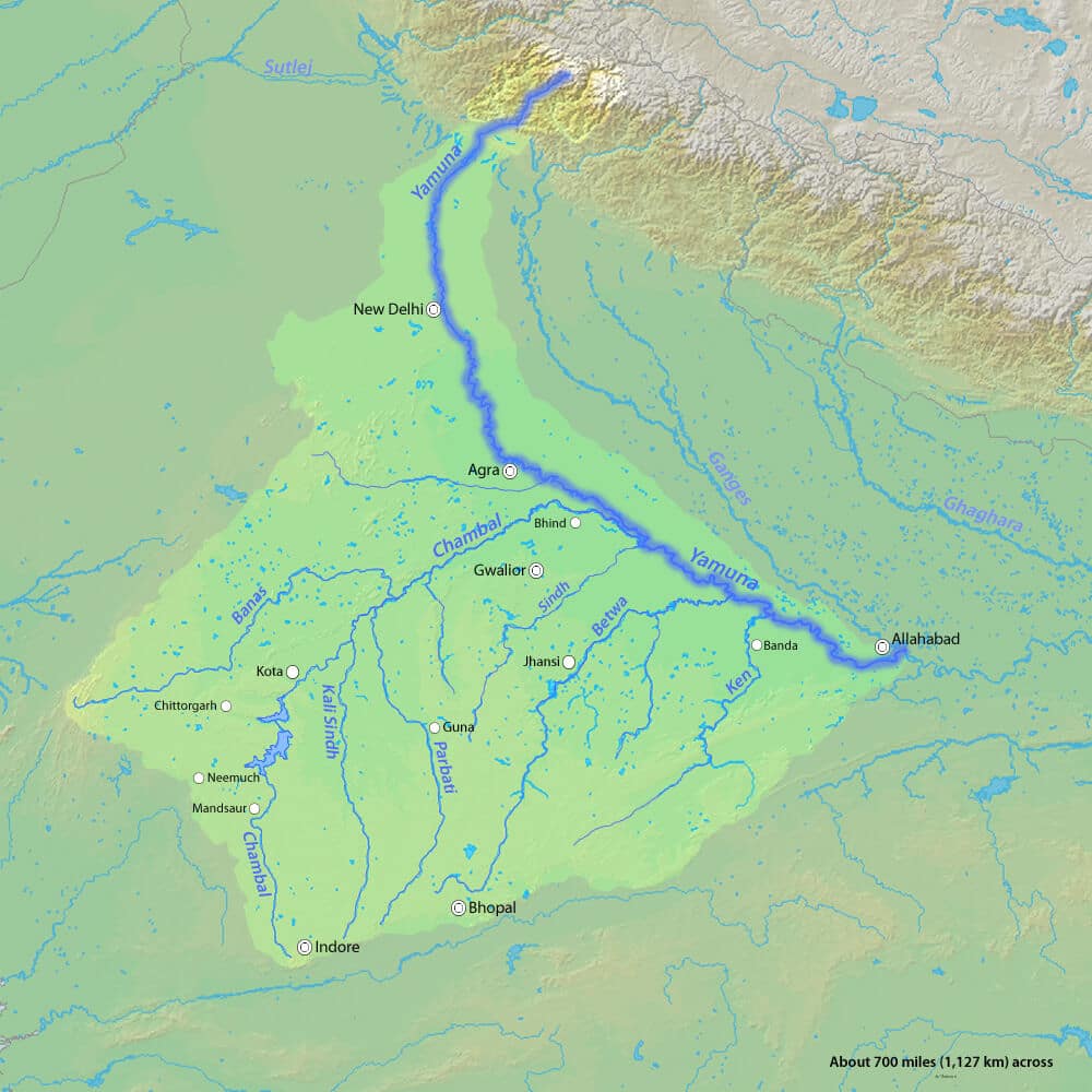
- Yamuna: the leading tributary of the Ganga, rising from the Yamunotri Glacier and joining at Prayagraj (Allahabad).
- Tributaries: Chambal, Sind, Betwa, Ken.
- Cities: Delhi, Mathura, Agra, Prayagraj. It is heavily drawn upon and highly polluted.
- Gambhir (Utangan): a tributary of the Yamuna, between the Yamuna and the Chambal.
- It rises in the Karauli hills of Rajasthan, in the north-eastern Aravalli country south-east of Jaipur.
- Before joining in Agra district it forms part of the Rajasthan–Uttar Pradesh boundary.
- Keoladeo Ghana Bird Sanctuary lies just north of it.
- Chambal: the longest tributary of the Yamuna, rising in the Janapao Hills of the Vindhyas and joining in Uttar Pradesh near Etawah.
- Tributaries: Banas, Kali Sindh, Parbati. Reservoirs: Gandhi Sagar, Rana Pratap Sagar, Jawahar Sagar.
- It is famous for ravines (badland topography), and forms part of the Rajasthan–Madhya Pradesh boundary.
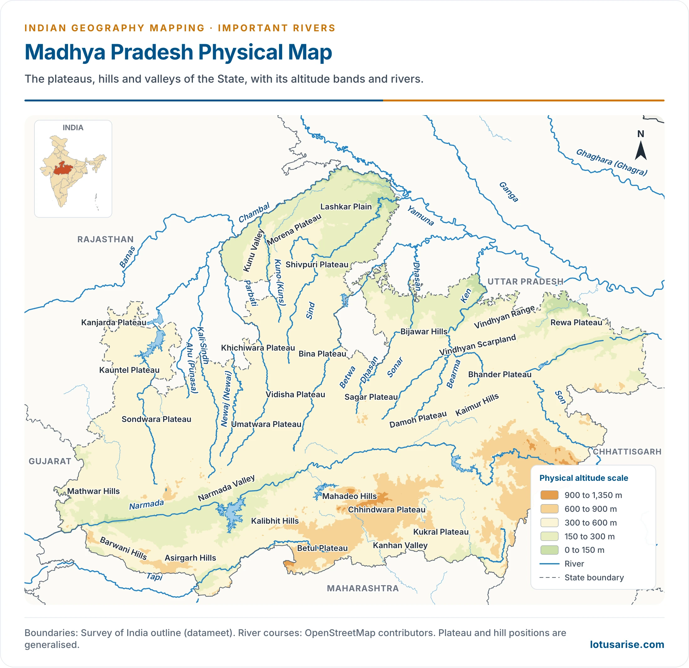
- Sind: a right-bank tributary of the Yamuna, between the Chambal and the Betwa, in Madhya Pradesh and Uttar Pradesh.
- It rises in Vidisha district and joins in Etawah district. Madikheda (Manikheda) Dam lies in Shivpuri district.
- Banas (Chambal tributary): the leading left-bank tributary of the Chambal, rising in the southern Aravallis and meeting it near the Rajasthan–Madhya Pradesh border.
- Ranthambore National Park lies by the confluence. Tributaries: Berach, Khairi, Bandi, Dhand.
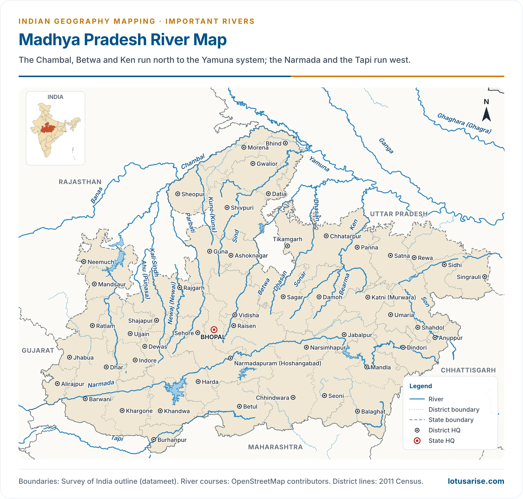
- Kali Sindh: the first important right-bank tributary of the Chambal, crossing the Malwa Plateau in Madhya Pradesh and Rajasthan.
- It crosses the Tropic of Cancer from south to north. Tributaries: Parwan, Ahu. It forms ravines in its lower course.
- Parbati: a right-bank tributary of the Chambal, on the Malwa Plateau.
- It crosses the Tropic of Cancer from south to north, and twice forms a short stretch of the Madhya Pradesh–Rajasthan boundary.
- Betwa: a tributary of the Yamuna, rising in the Vindhyan Range near Kumara village, Raisen district, and crossing the Bundelkhand Plateau.
- Dams: Matatila, Rajghat. Towns: Sanchi, Orchha.
- Ken: rises in the Kaimur Hills, given as Satna district in older accounts and now placed in Katni, and joins the Yamuna in Banda district.
- It crosses the Bundelkhand Plateau and almost dries up in summer.
- Ken–Betwa link: the foundation stone was laid on 25 December 2024, and completion is scheduled for 2030.
- Tons (Tamsa): a tributary of the Ganga, between the Yamuna and the Son, rising in the Vindhyan Range and joining a few kilometres below Prayagraj.
- Son: a right-bank tributary of the Ganga, rising near Amarkantak and joining about 16 km above Danapur, near Patna.
- It flows between the Kaimur Hills and the Sonpar Hills, makes several waterfalls, and forms a short Jharkhand–Bihar boundary.
- Tributaries: Johilla, Gopad, Rihand, Kanhar, North Koel.
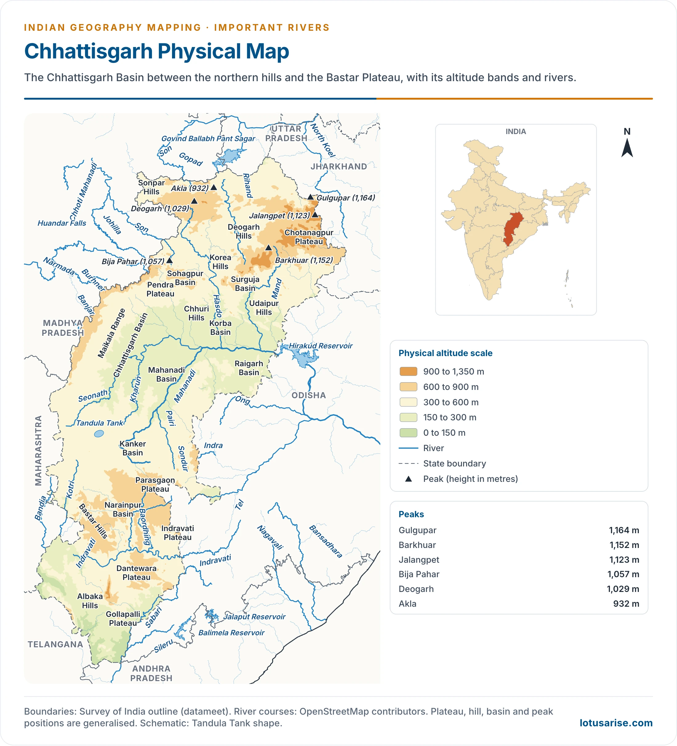
- Rihand: the chief tributary of the Son, rising in the Ramgarh hill tract of Surguja, Chhattisgarh, in the Matiranga hills, and joining in Sonbhadra district, once part of Mirzapur, Uttar Pradesh.
- Govind Ballabh Pant Sagar lies behind the Rihand Dam. It crosses the Tropic of Cancer.
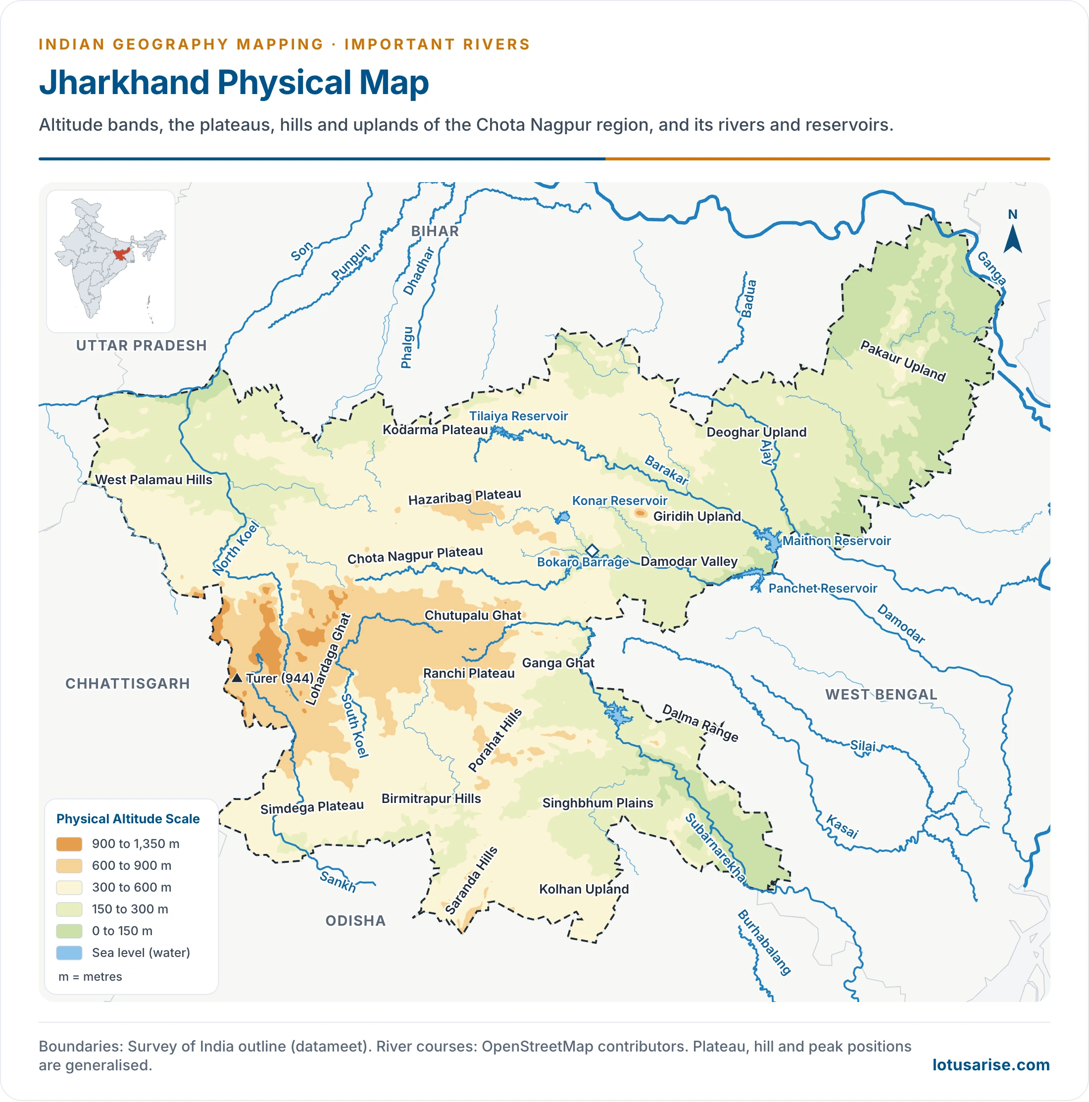
- North Koel: the last important tributary of the Son, rising on the Chotanagpur Plateau and joining at the Jharkhand–Bihar border.
- It crosses the Tropic of Cancer and the Palamau Tiger Reserve. Town: Medininagar (Daltonganj).
East-Flowing Rivers
- Subarnarekha: rises on the Ranchi Plateau and flows through Jharkhand, West Bengal and Odisha to the Bay of Bengal.
- Cities: Ranchi, Jamshedpur. Its name means “streak of gold”, and its valley is known for alluvial gold.
- Baitarani: a river of Odisha, rising in the Garhjat Hills, and reaching the Bay of Bengal beside the Mahanadi delta with the Brahmani.
- Dhamra Port stands at its mouth.
- Brahmani: a river of northern Odisha, formed by the Sankh and the South Koel.
- It reaches the sea on the northern side of the Mahanadi delta, after crossing the Garhjat Hills.
- Towns: Rourkela, Talcher. Its valley has rich coal deposits.
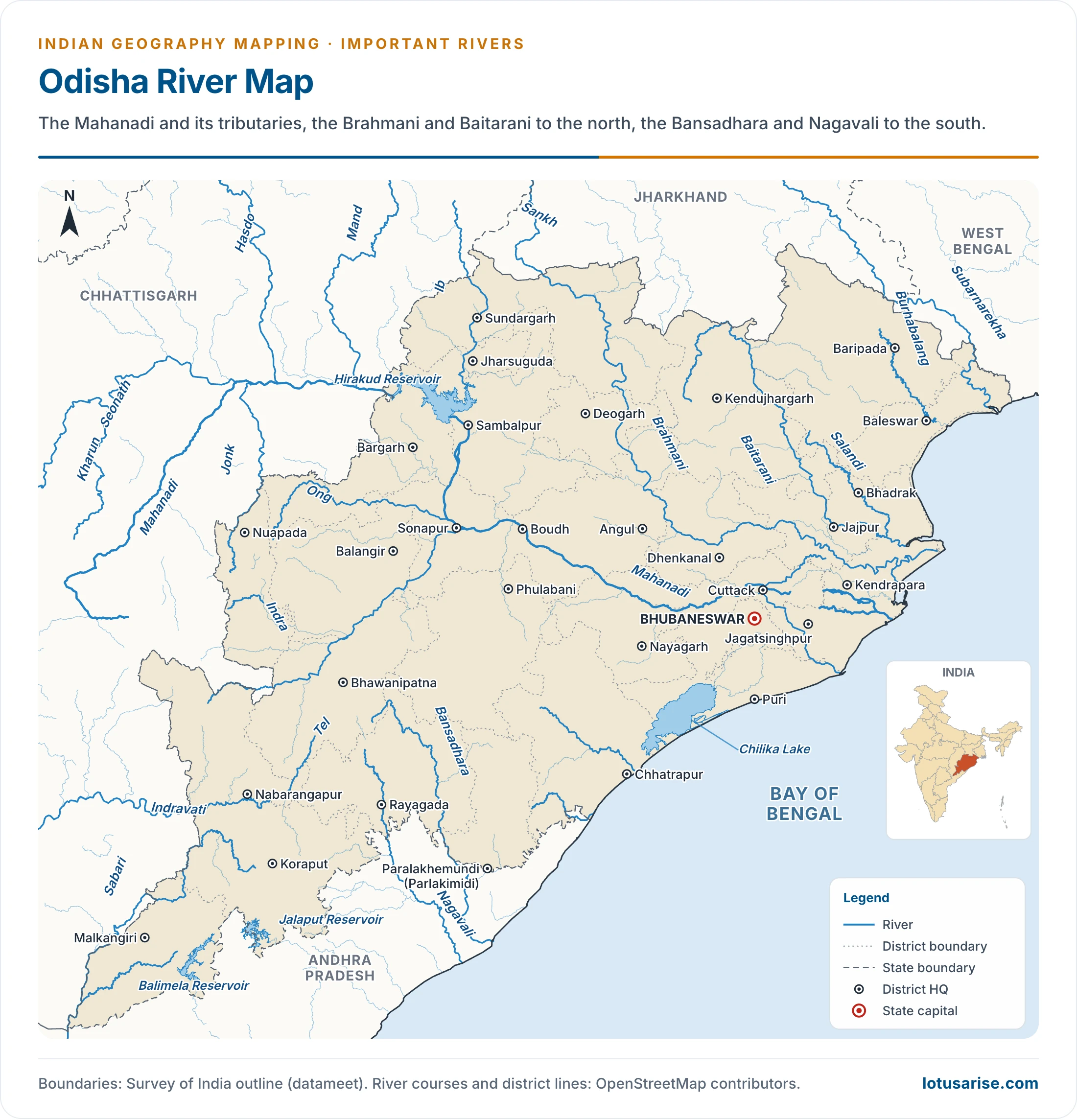
- Mahanadi: rises near Sihawa (Sihava Parbat), once in Raipur and now in Dhamtari district, Chhattisgarh, and builds a large delta on the Bay of Bengal.
- Hirakud Dam stands near Sambalpur in Odisha. Tributaries: Seonath (Sheonath), Hasdo, Ib, Mand, Jonk, Tel and others.
- Cities: Sambalpur, Cuttack. It drains the Chhattisgarh Plain, the “Rice Bowl of India”.
- Rushikulya: rises in the Daringbadi hills of Kandhamal, Odisha, and is about 165 km long. It reaches the Bay of Bengal in Ganjam district with no true delta, and its mouth is an olive ridley nesting beach.
- Vamsadhara (Banshadhara): a river of south-west Odisha and north-east Andhra Pradesh, rising in the Eastern Ghats. Its tribunal’s final order was notified on 30 March 2026.
- Sileru (Machkund): a left-bank tributary of the Sabari, which is the last major tributary of the Godavari. It rises in the Eastern Ghats and forms the Odisha–Andhra Pradesh boundary.
- Reservoirs: Jalaput, Machhkund, Balimela. Duduma Falls lies below the Machhkund Reservoir.
- Indravati: a left-bank tributary of the Godavari, rising in the Eastern Ghats at Thuamul Rampur in Kalahandi, Odisha, the hill country of Nimgiri (1,515 m).
- It runs through the Bastar Plateau, forms part of the Maharashtra–Chhattisgarh boundary, and joins at the trijunction of Maharashtra, Chhattisgarh and Telangana.
- City: Jagdalpur, the main city of Bastar.
- Wainganga: a left-bank tributary of the Godavari, rising in the eastern Mahadeo Hills of Madhya Pradesh.
- It joins the Wardha to form the Pranhita, which forms the Maharashtra–Telangana boundary. It also forms a short Madhya Pradesh–Maharashtra boundary.
- Tributaries: Pench, Kanhan, Mul. Towns: Balaghat, Bhandara, Gadchiroli.
- Wardha: rises in the southern Mahadeo Hills and receives the Penganga near Chandrapur, at Ghugus. It then joins the Wainganga. Tributaries: Bembla, Wunna.
- Penganga: rises in the Ajanta Range, follows the Maharashtra–Telangana boundary, and joins the Wardha. Tributaries: Aran, Pus.
- Purna (Godavari tributary): a small left-bank tributary, rising in the southern Ajanta Range.
- Godavari: the second largest river within India and the longest of southern India.
- It rises on the Trimbak Plateau in Nashik district and builds a large delta on the Bay of Bengal, adjoining that of the Krishna.
- It is known as “Vriddha Ganga”. Project: Jayakwadi. Tributaries: Pranhita, Indravati, Sabari with the Sileru, Manjra.
- Manjra: the leading right-bank tributary of the Godavari, rising in the Balaghat Range of Maharashtra and flowing through Karnataka and Telangana.
- Nizam Sagar stands on it near Nizamabad, Telangana. Tributaries: Tirna, Manar.
- Munneru (Muneru): the last important left-bank tributary of the Krishna, in Telangana and Andhra Pradesh. City: Khammam.
- Musi: a left-bank tributary of the Krishna, rising in the Anantagiri Hills of the Balaghat country on the Telangana Plateau.
- Hyderabad stands on it, and Hussain Sagar lies on a tributary.
- Bhima: the leading left-bank tributary of the Krishna, rising in the Bhimashankar hills of the Western Ghats, near Pune. Older accounts name the Matheran Hills.
- It flows through Maharashtra and Karnataka and joins 26 km from Raichur. Tributaries: Mula, Mutha, Ghod, Nira, Sina, Bari, Kagna.
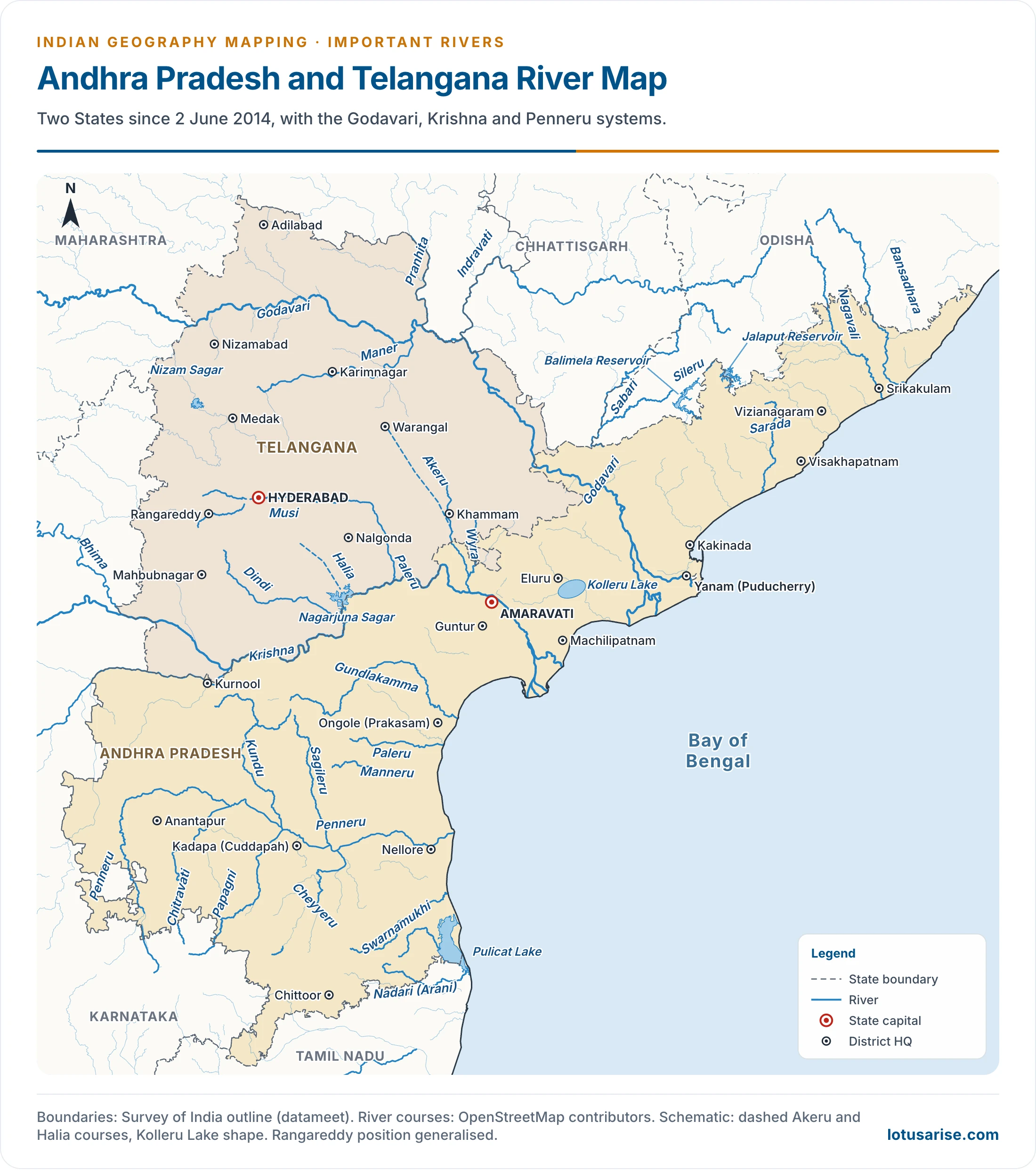
- Krishna: the second longest river of the Peninsula, rising in the Western Ghats near Mahabaleshwar and reaching the Bay of Bengal in a delta joined to that of the Godavari.
- Tributaries: Koyna, Tungabhadra, Bhima, Musi and others. Dams: Srisailam, Nagarjuna Sagar.
- Ghataprabha: a right-bank tributary of the Krishna in Karnataka, 283 km long, rising on the eastern slopes of the Western Ghats and joining at Almatti.
- Tributaries: Hiranyakeshi, Markandeya. The Ghataprabha Project at Hidkal is a dam and hydropower work.
- Gokak Falls lies in Belagavi (Belgaum) district.
- Malaprabha: a right-bank tributary in Karnataka, 304 km long, rising in the Western Ghats in Belagavi district and joining at Kudalasangama, Bagalkot district.
- Tributaries: Bennihalla, Hirehalla, Tuparihalla. Reservoir: Navilatirtha Dam.
- Aihole, Pattadakal and Badami stand on it.
- Tungabhadra: a major right-bank tributary, formed by the Tunga and Bhadra, rising near the Baba Budan Hills. It joins the Krishna a few kilometres below Kurnool, near Alampur.
- Tungabhadra Reservoir lies near Hosapete (Hospet). Tributaries: Varada, Hagari, Chikka Hagari.
- It forms a short Karnataka–Andhra Pradesh boundary. Towns: Hosapete, Hampi, Kurnool.
- Penneru (Pennar): the main river of southern Andhra Pradesh, rising in the Nandi hills, east of Tumakuru (Tumkur) in Karnataka, and reaching the Bay of Bengal near Nellore.
- It divides Rayalaseema into two nearly equal parts. It separates the Palkonda from the Nallamala, and crosses the Velikonda Range.
- Towns: Kadapa (Cuddapah), Nellore. Tributaries: Chitravati (Charavati), Papagni, Cheyyeru.
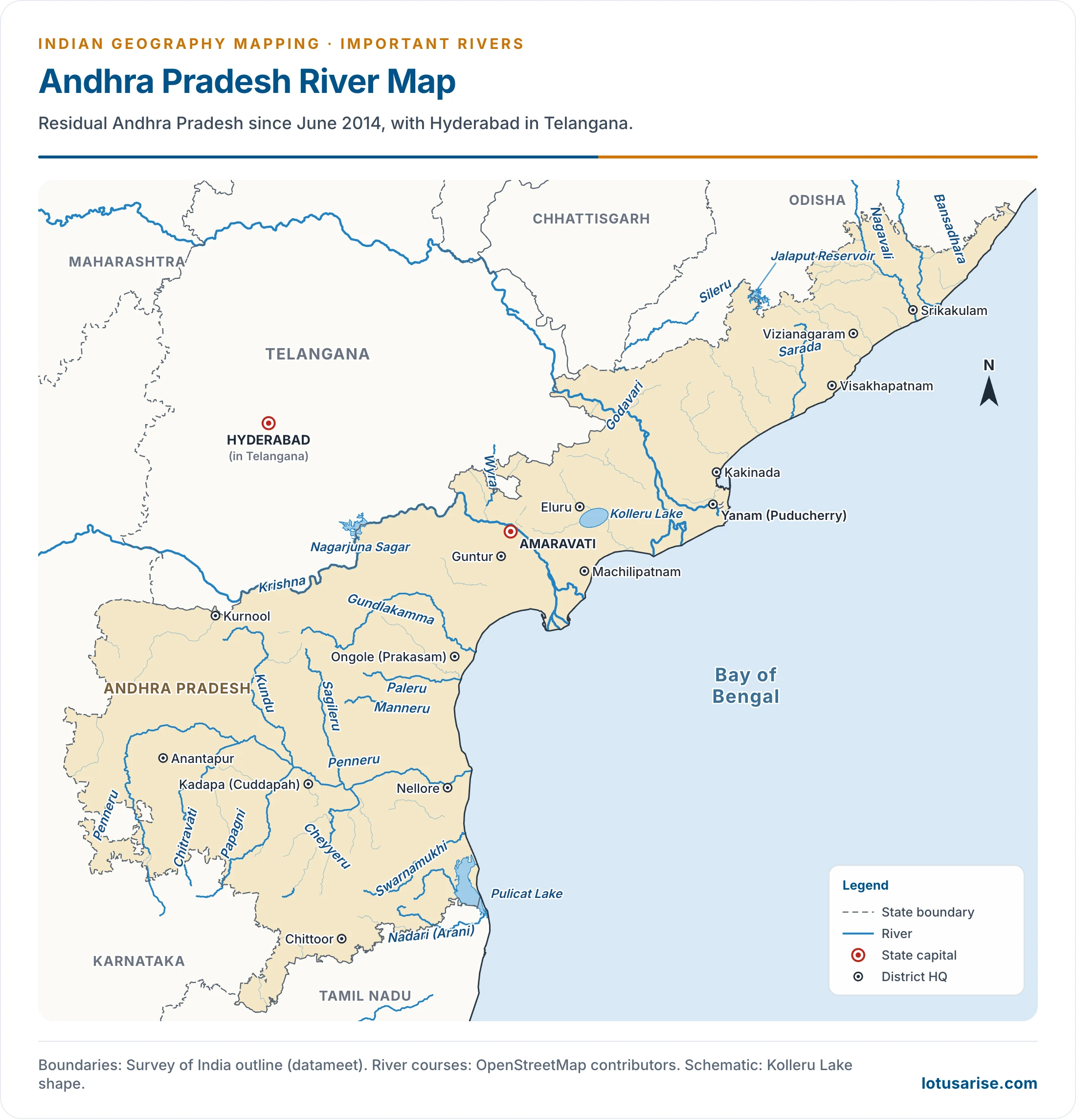
- Palar: a river of northern Tamil Nadu, rising in the Nandi Hills of Karnataka, near the Kolar gold field country. It reaches the sea midway between Chennai and Puducherry.
- Tributaries: Ponnai (Ponri), Cheyyar. Towns: Vellore, Kancheepuram.
- Ponnaiyar: a river of northern Tamil Nadu, coming down from the Melagiri Range region and flowing between the Javadi and Shevaroy Hills.
- Krishnagiri Reservoir stands on it. Tributary: Chovrai. Towns: Krishnagiri, Cuddalore at the mouth.
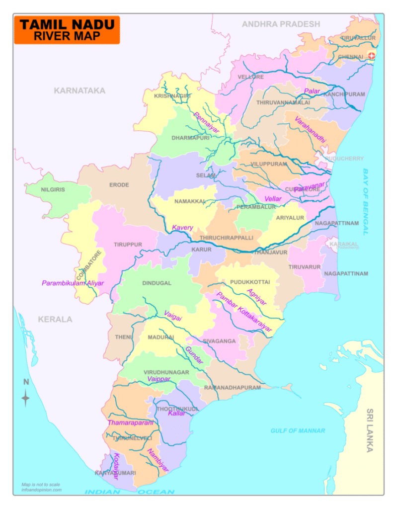
- Cauvery: rises at Talakaveri in the Brahmagiri Range of the Western Ghats, Karnataka, and forms a quadrilateral delta.
- Falls: Sivasamudram, Hogenakkal. Reservoirs: Krishnaraja Sagar, Stanley Reservoir (Mettur).
- Tributaries: Hemavati, Shimsha, Arkavati, Lakshmantirtha, Kabani, Suvarnavati, Noyil, Amaravati.
- Its waters are disputed among the riparian States.
- Hemavati: a left-bank tributary, wholly in Karnataka, rising near Ballalarayana Durga, in the hills south-west of the Baba Budan range. It meets the Cauvery at Krishnaraja Sagar. Tributary: Yagachi.
- Shimsha: a left-bank tributary, wholly in Karnataka, rising in Tumakuru district.
- It has the Shimsha Reservoir, and meets the Cauvery near Sivasamudram Falls.
- Arkavati: a left-bank tributary, wholly in Karnataka, flowing west of Bengaluru. Chamaraja Sagar stands on it.
- Noyil: a right-bank tributary, rising in the Vellingiri hills, south of the Nilgiris and near the Palghat Gap. Coimbatore stands on it.
- Lakshmantirtha: a right-bank tributary, rising in the Western Ghats and joining at Krishnaraja Sagar. It crosses Nagarhole National Park.
- Kabani: a right-bank tributary, rising near the Wayanad Sanctuary in Keralam (Kerala) and joining near Mysuru.
- Kabani Dam, 696 m long, stands near Mysuru. Its backwaters are among the most popular wildlife destinations of Karnataka.
- Moyar: a tributary of the Bhavani, rising in the Nilgiri Hills near Ooty. It joins at Bhavanisagar Reservoir, and the Bhavani then meets the Cauvery near Erode.
- It forms a short Karnataka–Tamil Nadu boundary.
- Amaravati: a right-bank tributary, rising south of the Anaimudi massif and joining a few kilometres below Karur.
- Tributaries: Sanmukta, Nanganji. City: Karur.
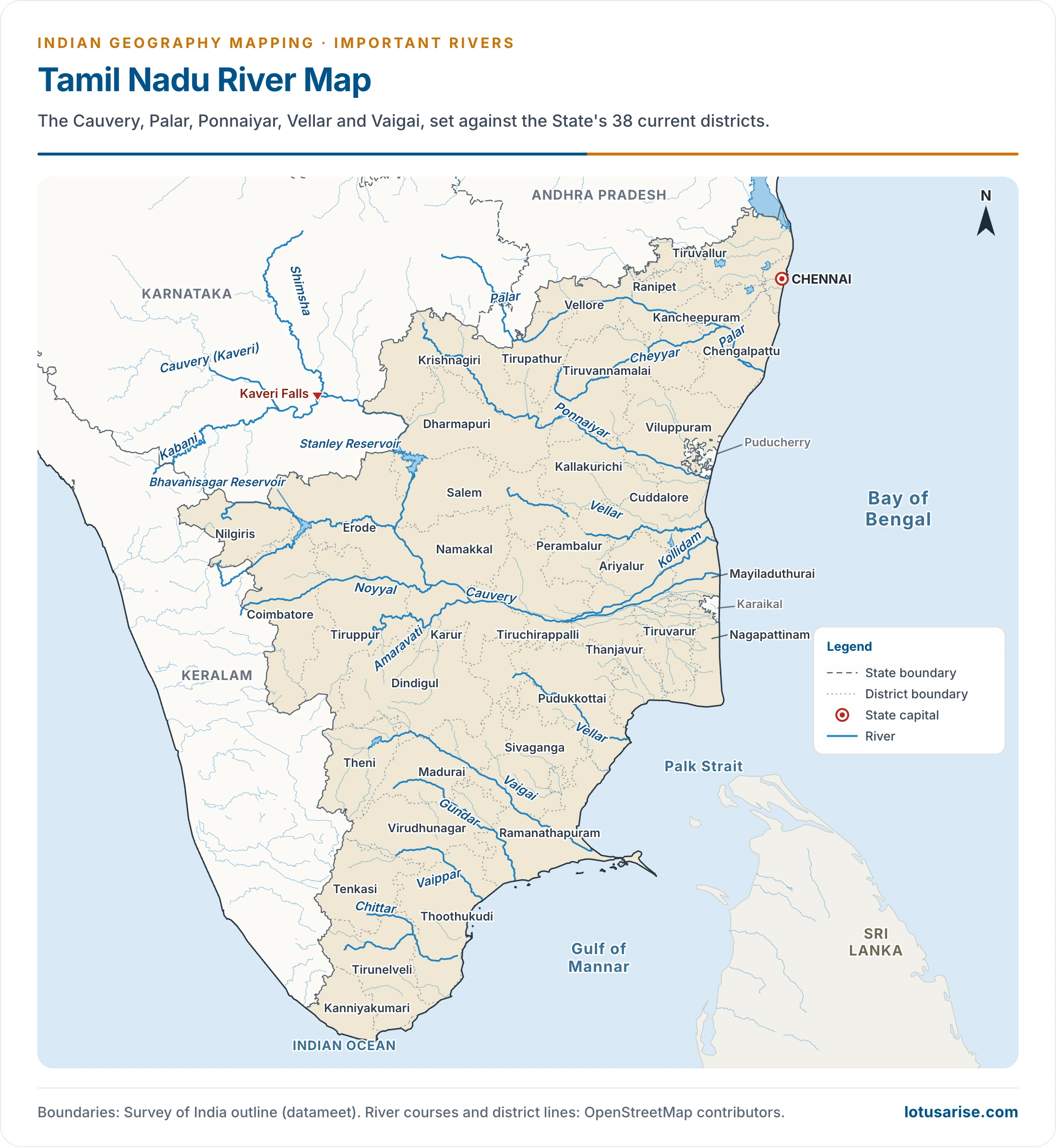
- Vaigai: the main river of southern Tamil Nadu, rising in the Cardamom Hills and flowing between the Varushanad and Sirumalai Hills.
- It ends near the Pamban Channel. Cities: Madurai, Ramanathapuram, Theni.
West-Flowing Rivers of the Western Ghats
- The west-flowing rivers of the Ghats are short and swift, and end in estuaries.
- Neyyar: a 56 km river of Thiruvananthapuram district, rising at Agasthyakoodam and reaching the sea at Poovar. Neyyar Dam and Wildlife Sanctuary lie on it.
- Pamba (Pambiyar): the third longest river of Keralam, rising in the Pulachimalai Hills and emptying into Vembanad Lake.
- The Sabarimala Temple stands in its basin. It irrigates the rice lands of Kuttanad and is venerated as the Dakshin Ganga.
- Periyar: the longest river of Keralam (244 km), known as its lifeline. It is a perennial source of drinking water.
- Idukki Dam gives hydropower in large quantity. It rises in the Shivagiri Hills and flows through Periyar National Park into the Periyar Reservoir.
- Water from the reservoir is diverted to the Vaigai.
- Kumaradhara (Kumardhar): a small river of south-west Karnataka, rising east of Kudremukh, in the Subramanya hills. It joins the Netravati at Uppinangady.
- Mangaluru (Mangalore) stands at the mouth of the combined river on the Arabian Sea.
- Sharavati: a west-flowing river of Karnataka, rising in Shivamogga (Shimoga) district and forming Jog Falls.
- It has the Linganamakki Reservoir, with the Sharavati and Mahatma Gandhi hydropower stations.
- Kalinadi (Kali): the northernmost major river of Karnataka’s coast, about 184 km long, rising near Diggi in the Western Ghats, west of Dharwad.
- It has hydropower projects, including Supa and Kadra. Karwar lies just south of its mouth.
- The Konkan Railway and the old NH-17, now NH-66, cross it.
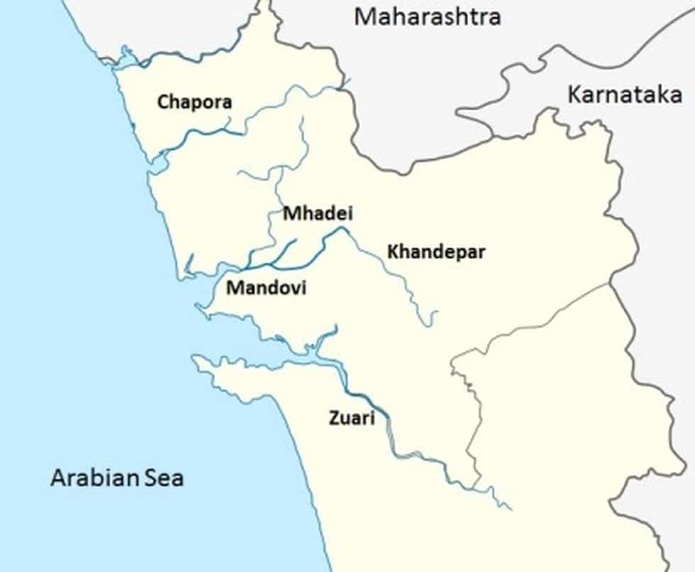
- Zuari: one of the two main rivers of Goa, with its head at Hemad–Barshem in the Western Ghats.
- Its length is given as 34 km in older accounts and about 92 km in others.
- With the Mandovi, it forms the backbone of Goa’s agriculture, and the Cumbarjua Canal (Cumbahuem) links the two.
- Vasco da Gama stands at its mouth.
- Mandovi (Mahadayi, Mahadei): the lifeline of Goa, rising at Bhimgad in Belagavi district, Karnataka.
- Its length is 77 km in older accounts (29 km in Karnataka, 52 km in Goa), about 81 km in others, and about 117 km where 35 km in Karnataka and 82 km in Goa are counted.
- Falls: Dudhsagar, Varapoha. Cities: Panaji, Old Goa.
- Ulhas: a west-flowing river near Mumbai, rising in the Western Ghats and emptying into Thane Creek.
- At Thane it branches in two, and the main branch reaches Vasai Creek.
Narmada, Tapi and the Rivers of Gujarat and Rajasthan
- Tapi: the second longest west-flowing river of the Peninsula, rising in Betul district of Madhya Pradesh, in the Mahadeo Hills, and emptying into the Gulf of Khambhat near Surat.
- It flows parallel to the Satpura Range. Tributaries: Purna, Girna, Bori, Panjhra.
- Ukai Dam stands on it. Towns: Kakrapar, Surat, Jalgaon, Bhusawal, Burhanpur.
- Purna (Tapi tributary): the leading tributary of the Tapi, rising in the Gawilgarh Hills and joining near Bhusawal, wholly in Maharashtra. Tributary: Mun.
- Narmada: the longest west-flowing river of the Peninsula, rising on the Amarkantak Plateau and emptying into the Gulf of Khambhat.
- It flows between the Vindhyas and the Satpuras, through a rift valley. Falls: Dhuandhar, Kapildhara.
- Dams: Sardar Sarovar, Omkareshwar, Maheshwar, Indira Sagar. Tributaries: Chhota Tawa, Hiran, Shakkar, Burhner.
- Chhota Tawa: a left-bank tributary of the Narmada, rising in the Satpura Range near the Madhya Pradesh–Maharashtra border.
- Khandwa and Nepanagar lie near it, and the Chhota Tawa Project stands on it.
- Mahi: rises in the north-western Vindhyan Range in Madhya Pradesh, and flows through Madhya Pradesh, Rajasthan and Gujarat to the Gulf of Khambhat.
- It crosses the Tropic of Cancer twice. Tributaries: Som, Anas, Panam.
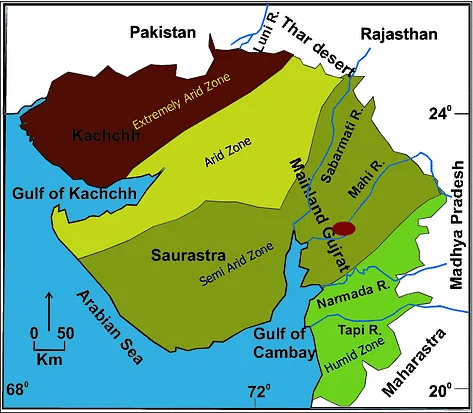
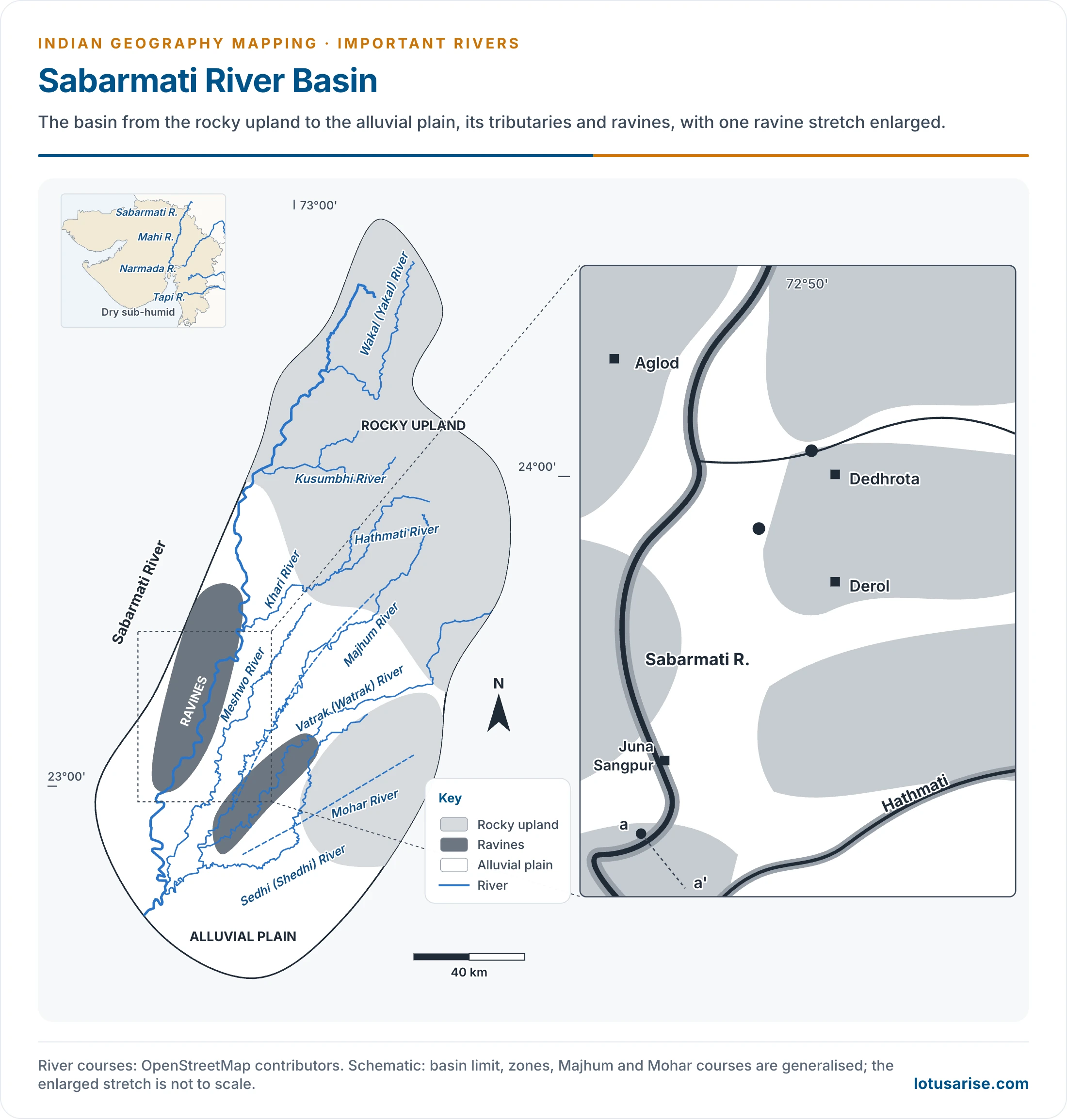
- Sabarmati: the combined stream of the Sabar and Hathmati, rising in the Mewar hills, in the southern Aravalli.
- It cuts a gorge at Dharoi and ends in the Gulf of Khambhat.
- Tributaries: Hathmati, Sedhi, Wakal (Wakrul), Harnav, Meshwo, Vatrak. Cities: Gandhinagar, Ahmedabad.
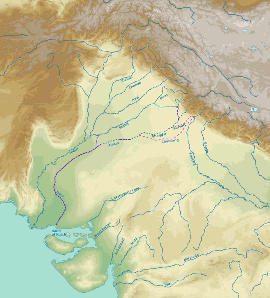
- Banas (West Banas): rises west of the Abu Hills in the southern Aravalli Range and vanishes in the Little Rann, forming inland drainage across Rajasthan and Gujarat.
- Luni: named for its water, which turns brackish below Balotra.
- It rises west of Ajmer in the Aravalli Range, at 772 m on current figures and 550 m in older ones, and flows south-west through the Thar Desert.
- It is lost in the Rann of Kachchh, as the leading inland drainage of India. Tributaries: Sukri (Sukai), Jawai.
- Ghaggar: a seasonal inland river, flowing along the Punjab–Haryana boundary and vanishing in the Thar Desert.
- It does not reach the sea. Its dry bed has been identified with the Saraswati of tradition, a view that remains debated.
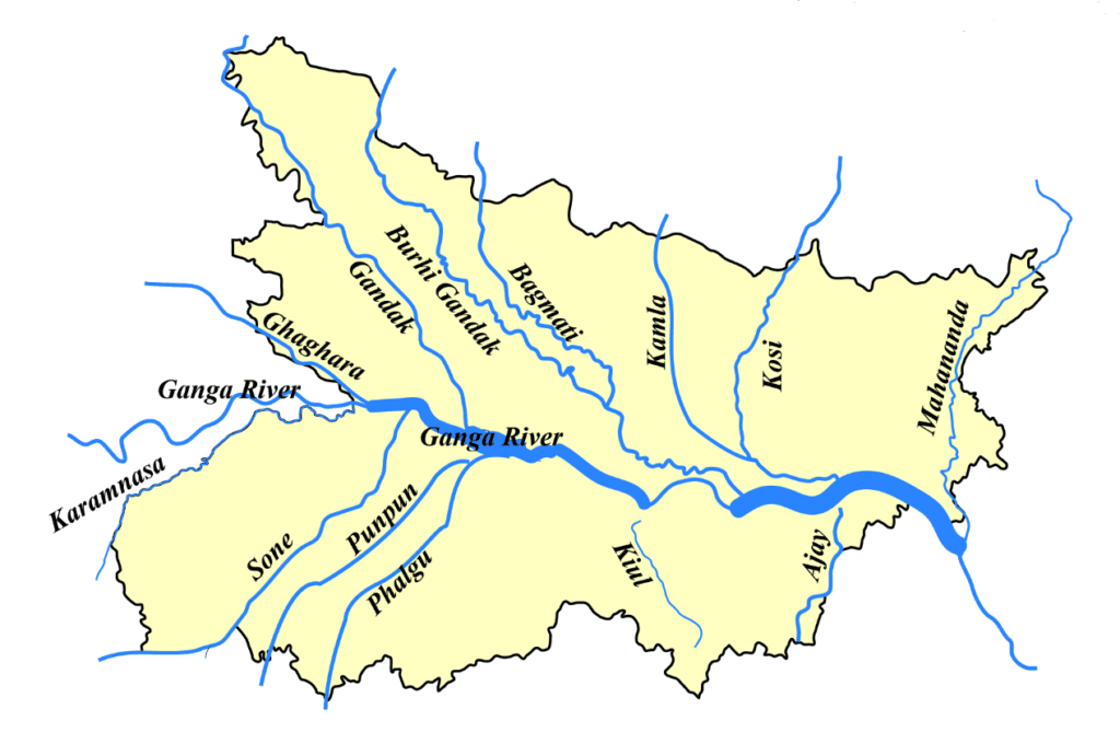
- Falgu (Phalgu): formed by the Lilajan and Mohana near Bodh Gaya, in Bihar.
- Gaya stands on it, and people perform pind daan in it there.
| State or UT | Rivers from this list |
|---|---|
| Ladakh and Jammu and Kashmir | Indus, Shyok, Zaskar, Gilgit, Jhelum, Chenab |
| Himachal Pradesh | Ravi, Beas, Satluj, Spiti, Parechhu |
| Uttarakhand | Tons, Bhagirathi, Alaknanda, Pindar, Kali, Ramganga |
| Sikkim and north Bengal | Teesta, Rangit, Mahananda, Raidak |
| Assam and Arunachal Pradesh | Brahmaputra, Dibang, Lohit, Subansiri, Kameng, Manas, Dikhu |
| Manipur and Mizoram | Barak, Manipur, Dhaleshwari |
| Odisha | Mahanadi, Brahmani, Baitarani, Rushikulya, Vamsadhara |
| Karnataka | Sharavati, Kalinadi, Hemavati, Shimsha, Arkavati, Malaprabha |
| Keralam | Periyar, Pamba, Neyyar, Kabani |
| Tamil Nadu | Palar, Ponnaiyar, Noyil, Moyar, Vaigai, Amaravati |
| Gujarat and Rajasthan | Sabarmati, Mahi, Banas, Luni, Ghaggar |
Previous Year Questions
2026Map item: Lohit River2026Map item: Mahi Basin2025Map item: Rushikulya River2025Map item: Neyyar2024Map item: Raidak River2023Map item: Betwa River2021Map item: Subarnarekha River2019Map item: River Beas2018Map item: Shyok River2018Map item: Neyyar2017Map item: Luni River2016Map item: River Indravati2013Map item: Beas River





I honestly didnot know that there were these many rivers in India 🇮🇳
This is just a Trailer! 😊
u r the best
super…………….amazing
You are the best only one on google chrome 🙏🏻🙏🏻🙏🏻🙏🏻🙏🏻🙏🏻🙏🏻🙏🏻🙏🏻🙏🏻🙏🏻🙏🏻🙏🏻🙏🏻🙏🏻🙏🏻🙏🏻🙏🏻🙏🏻🙏🏻🙏🏻🙏🏻📯📯📯📯📯📯📯📯📯📯📯📯📯📯📯📯
this very good composition of all the rivers
Incredible information