

- Among the Peninsula’s east-flowing rivers, the Krishna ranks second in size, behind the Godavari.
- It rises in Maharashtra in the west and meets the Bay of Bengal in Andhra Pradesh on the east coast, crossing the Peninsula from a source only about 64 km from the Arabian Sea.
- In older accounts it was called ecologically one of the most disastrous rivers in the world, for the heavy soil erosion it causes during the monsoon season. The ranking is rhetorical, but erosion and silt remain real problems.
The Krishna River and Its Basin
Course
- Source: near Jor village, in the extreme north of Satara district of Maharashtra, just north of Mahabaleshwar, at an altitude of 1,337 m.
- Length: 1,400 km from origin to outfall.
- Delta: the Krishna builds a large delta, whose coast runs for about 120 km.
- Its area is about 4,600 sq km, and it pushes some 35 km seaward.
- It seems to merge with the Godavari delta, so that the two form one coastal tract.
- Flow: the river is fed by seasonal monsoon rain, so its flow fluctuates widely through the year. This limits direct irrigation without storage.
- About 90% of the basin’s rainfall arrives in the monsoon, more than 70% of it in July to September. Mean annual rainfall is 784 mm.
Basin
- States: older lists give Maharashtra, Karnataka and Andhra Pradesh. Since 2014 the last share is divided between Andhra Pradesh and Telangana.
- Older State figures are Karnataka 1,13,271 sq km, Andhra Pradesh (undivided) 76,252 and Maharashtra 69,425.
- Area: 2,58,948 sq km, about 8% of India. The 2019 Central Water Commission (CWC) assessment gives 2,59,439 sq km.
- The basin is wide in the west and narrows steadily towards the delta.
- Bounded by the Balaghat range on the north, the Eastern Ghats on the south and east, and the Western Ghats on the west.
- Water: older mean flow is about 67,670 million cubic metres, with a basin figure of 78.1 cubic km. The 2019 CWC figure is 89.04 billion cubic metres.
- Land use: agricultural land covers 75.86% of the basin, the highest share of the major Peninsular rivers.
- Geology: Deccan Traps in the north-west, crystalline rocks with Dharwars in the centre, and the Cuddapah Group in the east. The delta is Pleistocene to recent material.
- Major dams on the main river: Almatti Dam, Srisailam Dam, Nagarjuna Sagar Dam and Prakasam (Prakasham) Barrage.
- Urban and tourist centres on its bank: Satara, Karad, Sangli, Bagalkot, Srisailam, Amaravati and Vijayawada.
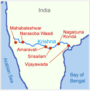
- On this small map, Amaravati is drawn upstream of Srisailam. It lies downstream of Nagarjuna Sagar, close to Vijayawada.
Tributaries of the Krishna
Pattern
| Bank | Major tributaries |
|---|---|
| Right | Venna, Koyna, Panchganga, Dudhganga, Ghataprabha, Malaprabha, Tungabhadra |
| Left | Bhima, Dindi, Peddavagu, Halia, Musi, Paleru, Munneru |
| Tributary | Length (km) | Drainage (sq km) | Source elevation (m) |
|---|---|---|---|
| Koyna | 118 | 4,890 | 1,441 |
| Panchganga | 74 | 2,575 | 1,020 |
| Dudhganga | 103 | 2,350 | 870 |
| Ghataprabha | 283 | 8,829 | 884 |
| Malaprabha | 304 | 11,549 | 793 |
| Bhima | 861 | 70,614 | 945 |
| Tungabhadra | 531 | 71,417 | 610 |
| Dindi | 178 | 3,490 | 718 |
| Peddavagu | 109 | 2,343 | 707 |
| Halia | 112 | 3,780 | 708 |
| Musi | 265 | 11,212 | 661 |
| Paleru | 152 | 3,263 | 515 |
| Munneru | 195 | 10,409 | 238 |
- The Tungabhadra and Bhima are the two largest, each draining more than a quarter of the basin.
- Koyna: a small tributary, known for Koyna Dam.
- The dam is linked to the devastating earthquake of December 1967. Older figures say magnitude 6.4 and 150 deaths. Current work gives magnitude 6.3 and about 200 deaths.
- It remains the largest accepted reservoir-triggered earthquake in the world.
- Bhima: it joins the Krishna near Raichur. Older sources name the Matheran hills as its source, but the Bhimashankar hills are the accepted one.
- Tungabhadra: formed where the Tunga and the Bhadra unite, both rising at Gangamula in the central Sahyadri. It runs 531 km in all.
- Musi: the last important tributary, entering at Wazirabad. Hyderabad stands on its banks.
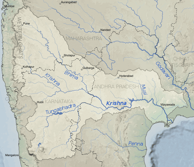
- This map predates 2014. The area labelled Andhra Pradesh around Hyderabad now lies in Telangana.
Bhima
- It rises in the Bhimashankar hills near Karjat, in the Western Ghats (Sahyadri) of Maharashtra.
- It flows south-east through Maharashtra, Karnataka and Andhra Pradesh (the last now Telangana). Older accounts give 725 km, while CWC gives 861 km.
- Sub-tributaries: Mula, Mutha, Ghod and Nira.
- Temples on its banks:
- Bhimashankar, one of the twelve Jyotirlinga shrines.
- Siddhatek, the Siddhivinayak temple of the Ashtavinayak Ganesh.
- Pandharpur Vithoba Temple.
- Sri Dattatreya Temple.
- Sri Kshetra Rasangi Balibheemasena Temple.
Musi
- Known in olden days as the Muchukunda river, it rises in the Anantagiri Hills near Vikarabad, in the former Rangareddi district, 90 km west of Hyderabad.
- Osmansagar was built across it at Gandipet village in 1920.
- Himayat Sagar is another key dam, and Hussain Sagar Lake was built on a tributary. Together they have served as a water source for Hyderabad.
- The river has also hosted water festivals: boat races, decorated boat contests and swimming tournaments.
Koyna
- It rises at Mahabaleshwar in Satara district of Maharashtra.
- Most Maharashtra rivers flow east–west, but the Koyna runs north–south, a striking break along the Sahyadri.
- Koyna Dam is the largest hydroelectric project in Maharashtra, at Koyna Nagar in the Western Ghats.
- Its reservoir, Shivasagar Lake, is about 50 km long.
- It meets the Krishna at Karad.
- It is only about 100 m wide and flows slowly.
Panchganga
- It flows along the borders of Kolhapur.
- It is formed by four streams: the Kasari, Kumbhi, Tulsi and Bhogawati.
- The Prayag Sangam marks where the Panchganga proper begins, enlarged by these four streams.
- North of Kolhapur it spreads over a wide alluvial plain, then resumes its eastward course.
- It falls into the Krishna at Kurundvad.
Dudhganga
- A right-bank tributary of the Krishna and an important river of Kolhapur district.
- Kallammawadi Dam stands on it, built in collaboration with Karnataka.
Ghataprabha
- It rises in the Western Ghats at 884 m and flows east for 283 km across Maharashtra and Karnataka, joining the Krishna at Almatti.
- Gokak waterfall, in Belgaum district, is a noted attraction.
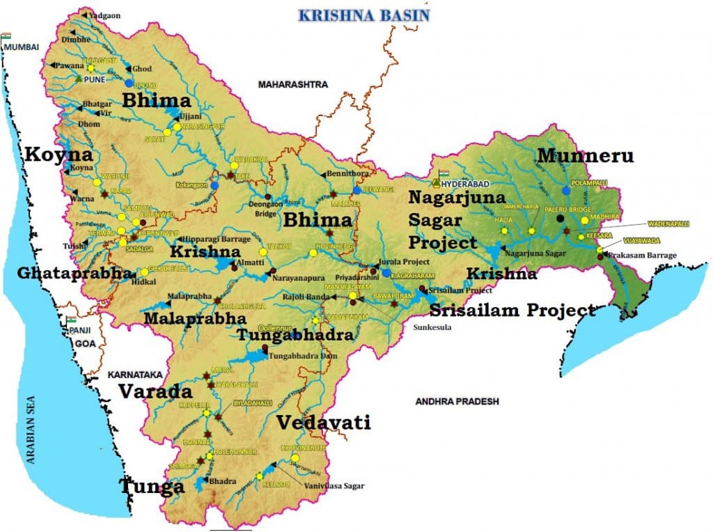
- The Ghataprabha Project is a hydroelectric and irrigation dam across the river. Its main storage is at Hidkal, shown on the basin map, and its canals serve Belgaum and Bijapur.
Malaprabha
- It rises at Kanakumbi in Belgaum District of Karnataka, at about 792 m in the Sahyadris.
- It flows 304 km and joins the Krishna at 488 m, at Kudalasangama in Bagalkot district.
- Navilatirtha Dam, near Munavalli in Belgaum, holds the reservoir called Renukasagara.
- The temples of Aihole, Pattadakal and Badami stand on its banks.
- All three are often listed as World Heritage sites. Only the Group of Monuments at Pattadakal is inscribed, since 1987. Aihole and Badami are on UNESCO’s tentative list as an extension.
Tungabhadra
- Its ancient name was Pampa.
- It forms where the Tunga and Bhadra meet, both flowing down the eastern slope of the Western Ghats in Karnataka.
- It meanders across the plains for 531 km and joins the Krishna at Gondimalla, near Alampur in the former Mahaboobnagar District, now in Telangana.
- Varada, Hagari and Handri are its main tributaries.
- The land between the Tungabhadra and the Krishna, lying north of the former, is the Raichur Doab.
- Urban centres: Harihar, Hospet, Hampi, Mantralayam and Kurnool.
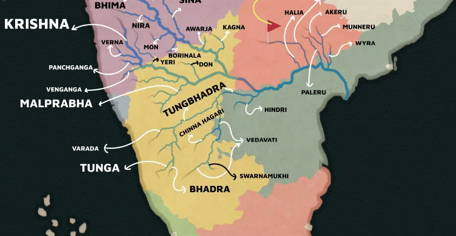
- This map’s “Tungbhadra” is the Tungabhadra, and its “Verna” and “Venganga” are the Varna and the Vedganga, both sub-basin streams on the upper right bank.
Development of the Basin
Projects on the Krishna River
- Important projects: Tungabhadra, Ghataprabha, Nagarjunasagar, Malaprabha, Bhima, Bhadra and Telugu Ganga.
- Major hydropower stations: Koyna, Tungabhadra, Sri Sailam, Nagarjuna Sagar, Almatti, Narayanpur (Naryanpur) and Bhadra.
- Inter-State management: the Tungabhadra is the basin’s major inter-State project. The Tungabhadra Board operates it and regulates flows between Karnataka and Andhra Pradesh.
| Project | River | Location | Note |
|---|---|---|---|
| Tungabhadra | Tungabhadra | Near Hospet, Karnataka | Power, irrigation, municipal water, flood control |
| Srisailam | Krishna | Former Kurnool district, Andhra Pradesh | Reservoir: Srisailam Sagar or Neelam Sanjjeva Reddy Sagar |
| Nagarjuna Sagar | Krishna | Between Nalgonda and Guntur districts | Inaugurated 1955, masonry dam 124.7 m high |
| Prakasam Barrage | Krishna | Near Vijayawada | Built 1954–57 upstream of Cotton’s anicut |
| Ghatprabha | Ghataprabha | Near Chandgad, Kolhapur (Maharashtra part) | Krishna basin project |
| Bhima | Bhima | Solapur district, Maharashtra | Krishna basin project |
- Tungabhadra dam: first conceived by Sir Arthur Cotton in 1860, it took shape only under a 1944 Madras–Hyderabad agreement.
- On the night of 10 August 2024 its crest gate number 19 was washed away, the first such failure in its history.
- Nagarjuna Sagar: work is sometimes dated to 1950. Jawaharlal Nehru inaugurated it on 10 December 1955.
- It was among India’s earliest large infrastructure projects. It is often tied to the Green Revolution, which came a decade later, though the two came to reinforce one another.
- Prakasam Barrage: Sir Arthur Cotton, the East India Company engineer, designed the original Krishna anicut, built by Captain Charles Orr and finished in 1855.
- The damaged anicut was replaced by the present barrage in 1957.
- Almatti: its storage height is itself a dispute, between 519.6 m and a permitted 524.256 m.
Resources in the Krishna Basin
- The basin has rich mineral deposits and good potential for industry.
- Iron and steel, cement, sugarcane, vegetable oil extraction and rice milling are the present industrial activities.
- Oil has been struck recently, in the older phrase, and this should shape future industry. The find lies in the offshore Krishna–Godavari basin.
Industry in the Krishna Basin
- Major urban centres: Pune and Hyderabad.
- Hyderabad, capital of Telangana, is now a major IT hub.
- Pune in Maharashtra has many automobile and IT firms and is a major education centre.
Drought and Floods in the Krishna Basin
- Drought-prone areas:
- Andhra Pradesh: the Rayalaseema area.
- Karnataka: Bellary, Raichur, Dharwar, Chitradurga, Belgaum and Bijapur.
- Maharashtra: Pune, Sholapur, Osmanabad and Ahmednagar (Ahmedanagar).
- Delta floods: silt keeps raising the river bed in the delta and so reduces channel capacity.
- Cyclones: intense, short coastal cyclonic rain makes the flood problem worse.
Water Disputes
- First tribunal: the Krishna Water Disputes Tribunal (Bachawat), set up on 10 April 1969, reported in 1973 and 1976.
- It worked from a dependable flow of 2,060 tmc at 75% dependability, or 2,130 tmc with return flows.
- Shares: Maharashtra 585, Karnataka 734, undivided Andhra Pradesh 811 tmc.
- Second tribunal: the Krishna Water Disputes Tribunal-II (Brijesh Kumar), constituted in April 2004, gave its decision on 30 December 2010 and a further report on 29 November 2013.
- It kept the earlier shares and used 65% dependability (2,293 tmc) and the average yield (2,578 tmc) for the additional water.
- Shares: Maharashtra 666, Karnataka 911, Andhra Pradesh 1,001 tmc.
- It also allowed Almatti to rise to 524.256 m.
- Status: a Supreme Court order of 16 September 2011 bars gazette publication until further orders, so this award is not in force.
- After bifurcation: the Andhra Pradesh Reorganisation Act, 2014 asked the same tribunal to divide the undivided share. Further terms issued on 6 October 2023 confine that task to Telangana and Andhra Pradesh.
- Its period was extended to 31 July 2026, and hearings were still being held in 2026.





This is a good enough article. Thanks!
NICE presentation
Thank you so much👍😇
Now the Musi River (Tributary of Krishna) is highly polluted river along its Course , People use the River as a Dump-yard and Many industries release a very harmful Chemicals into the river , It is a Major source of Urban Floods in the city of Hyderabad , Illegal & Carelessness in construction of Houses or Huts by people along side the Musi even Creates a Huge problem when the areas Floods , Hope in future the Government will come up with a Permanent Solution.
Thanks Very crisp and helpful.
thank you