

- A multipurpose project is the scientific management of a river’s water through one massive scheme that serves several ends together.
- Its usual aims are flood control, fish breeding, irrigation, electricity, soil conservation, navigation and tourism.
- A plain hydropower project is built mainly to give electricity.
- Such schemes have marked India’s planned development since 1951. Most are built around one or more dams.
Purpose and Problems
Objectives and Advantages
- Power: these projects give clean, pollution-free electricity, long regarded as the cheapest, which supports both industry and farming.
- The Economic Survey 2005-06 credited them with more than 30,000 MW.
- All large hydro stood at 52,064.66 MW on 30 September 2026.
- Flood control: storage lets a dam hold back flood water, and so turn a “river of sorrow” into a boon.
- The Kosi, known as the sorrow of Bihar, and the Damodar are the standard cases.
- Soil conservation: slower water carries away less soil.
- Irrigation: canals carry stored water to fields in the dry season and to dry tracts.
- Afforestation: trees planted around the reservoir help to preserve wildlife and the natural ecosystem.
- Water navigation: the river or canal offers inland transport, the cheapest way of moving heavy goods.
- Fisheries: reservoirs give ideal breeding conditions, and selected varieties of fish are raised in them.
- Tourist centres: well-kept and scientifically developed sites draw visitors.
Disadvantages
- Fertile farmland goes under water.
- Forest land is cleared or submerged, a heavy loss for the environment.
- Large numbers of people are displaced and must leave their homes and property.
- Bargi alone dislocated about 1 lakh people in 162 villages. Tehri drowned old Tehri town and 23 villages.
- Siltation shortens the working life of a project.
- Gobind Sagar lost over half a million acre-feet of storage in 25 years, from 6.03 million acre-feet (1963) down to 5.5 million (1988).
- Big projects can set off minor earthquakes, as Koyna and Warna show.
List of Multipurpose Projects in India
Indus Basin and the North-West
| Project | River | State or UT |
|---|---|---|
| Bhakra Nangal | Satluj (Sutlej) | Punjab, Himachal Pradesh, Haryana, Rajasthan |
| Beas Project (Vyas Project) | Beas (Vyas) | Punjab, Haryana, Rajasthan, Himachal Pradesh |
| Pong | Beas | Dam in Himachal Pradesh (Kangra); benefits Punjab, Haryana, Rajasthan |
| Ranjeet Sagar | Ravi | Punjab, on the Jammu and Kashmir border |
| Kol Dam | Satluj | Himachal Pradesh |
| Nathpa Jhakri | Satluj | Himachal Pradesh |
| Mandi Project | Tributary of the Beas (Vyas) | Himachal Pradesh |
| Sutlej Project | Satluj works lie in Himachal Pradesh and Punjab; the Chenab schemes are Salal and Dulhasti | See those rows |
| Sarhind (Sirhind) | Satluj | Punjab, Haryana |
| Indira Gandhi Canal (Rajasthan Canal) | Satluj, Beas, Ravi waters | Rajasthan, Punjab, Haryana |
| Salal | Chenab | Jammu and Kashmir (Reasi) |
| Dulhasti | Chenab | Jammu and Kashmir (Kishtwar) |
| Uri Power Project | Jhelum | Jammu and Kashmir (Baramulla) |
| Tulbul | Jhelum, at the Wular outlet | Jammu and Kashmir |
Ganga Basin
| Project | River | State or UT |
|---|---|---|
| Tehri Dam | Bhagirathi | Uttarakhand |
| Ramganga | Ramganga | Uttarakhand (Kalagarh), benefiting Uttar Pradesh |
| Madhya Ganga Canal | Ganga | Uttar Pradesh |
| Left Bank Ghaghra Canal | Ghaghra, in the Ganga system | Uttar Pradesh |
| Sharda Project | Sharda, Gomti | Uttar Pradesh |
| Gandak | Gandak (Gandaki) | Bihar, Uttar Pradesh, with Nepal |
| Kosi | Kosi | Bihar and Nepal |
| Rihand | Rihand | Uttar Pradesh |
| Bansagar | Son | Madhya Pradesh, Uttar Pradesh, Bihar |
| Matatilla | Betwa | Uttar Pradesh, Madhya Pradesh |
| Chambal Project | Chambal | Rajasthan, Madhya Pradesh |
| Gandhi Sagar (Ganga Sagar) | Chambal | Madhya Pradesh |
| Rana Pratap Sagar | Chambal | Rajasthan |
| Jawahar Sagar | Chambal | Rajasthan |
| Farakka | Ganga, Bhagirathi | West Bengal |
Eastern India
| Project | River | State or UT |
|---|---|---|
| Damodar Ghati (Damodar Valley) | Damodar | Jharkhand, West Bengal |
| Panchet | Damodar | Jharkhand, West Bengal |
| Tilaiya | Barakar | Jharkhand |
| Durga Barrage (Durgapur Barrage) | Damodar | West Bengal; dams above it in Jharkhand |
| Mayurakshi | Mayurakshi | West Bengal |
| Kangsawati | Kangsawati | West Bengal |
| Hirakud | Mahanadi | Odisha |
| Mahanadi Delta | Mahanadi | Odisha |
| Hasdeo Bango (Minimata Bango) | Hasdeo | Chhattisgarh |
| Muchkund (Machkund) | Muchkund | Odisha, Andhra Pradesh |
| Umiam | Umiam | Meghalaya, near Shillong |
Central and Western India
| Project | River | State or UT |
|---|---|---|
| Bargi | Narmada | Madhya Pradesh |
| Narmada Sagar (Indira Sagar) | Narmada | Madhya Pradesh, with benefits to Gujarat |
| Tawa | Tawa | Madhya Pradesh |
| Sardar Sarovar | Narmada | Gujarat, Madhya Pradesh, Maharashtra, Rajasthan |
| Kakrapara | Tapi | Gujarat |
| Ukai | Tapi | Gujarat |
| Panam (Panama in some lists) | Panam | Gujarat |
Deccan and the South
| Project | River | State or UT |
|---|---|---|
| Bheema | Bhima, with Pawana | Maharashtra |
| Girna | Girna | Maharashtra |
| Jayakwadi | Godavari | Maharashtra |
| Koyana (Koyna) | Koyna | Maharashtra |
| Purna | Purna | Maharashtra |
| Upper Penganga | Penganga | Maharashtra |
| Nagpur Power Project | Koradi, near Nagpur | Maharashtra |
| Poochampad | Godavari | Telangana |
| Krishna Project | Krishna | Karnataka |
| Ghatprabha (Hidkal) | Ghatprabha | Karnataka |
| Malprabha | Malprabha | Karnataka |
| Nagarjunsagar | Krishna | Telangana, Andhra Pradesh |
| Tungabhadra | Tungabhadra | Karnataka, Andhra Pradesh |
| Bhadra | Bhadra | Karnataka |
| Sharawati | Sharavati | Karnataka |
| Shivsamundram | Kaveri (Cauvery) | Karnataka |
| Idduki (Idukki) | Periyar | Keralam (Kerala) |
| Kunda (Kundah) | Kundah | Tamil Nadu |
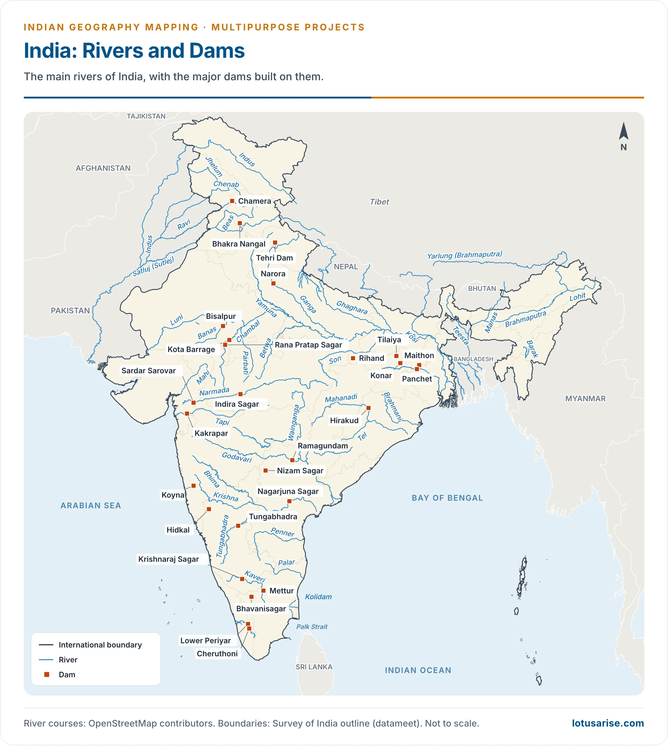
The Projects in Detail
Satluj, Beas and Ravi
- Bhakra Nangal Project: the largest of the early schemes, and a shared scheme of Punjab, Haryana and Rajasthan.
- Works: two dams, the Nangal Hydel Channel, power houses, transmission lines and the Bhakra canals.
- The Nangal Hydel Channel is a cemented canal 64.4 km long that falls about 70 m. It turns the turbines below Nangal and also feeds the irrigation canals.
- The main Bhakra canal runs 174 km. The system commands about 27 lakh hectares and irrigates about 15 lakh, split 46.7% Haryana, 37.7% Punjab and 15.6% Rajasthan.
- Scale: some 14 million cubic metres of building material, and 70 million man-days on the canals.
- Bhakra Dam:
- One of the world’s highest straight gravity dams, on the Satluj at the Bhakra gorge near Rupnagar (Ropar), in Bilaspur district of Himachal Pradesh.
- About 226 m high (222 m in older accounts) and 518 m long.
- It forms Gobind Sagar.
- Power: 450 MW + 600 MW in the first scheme, 1,379 MW after uprating (left bank 594 MW, right bank 785 MW).
- Govind Sagar (Gobind Sagar):
- The reservoir behind Bhakra, 88 km by 8 km, honours Guru Gobind Singh, the tenth Sikh Guru.
- Gross storage is quoted between about 962 and 987 crore cubic metres, with 969.8 crore a common figure.
- Nangal Dam:
- About 13 km downstream of Bhakra on the Satluj, 29 m high and 305 m long.
- It is a balancing reservoir that absorbs daily swings in release from Bhakra.
- Power houses at Ganguwal and Kotla. Same joint venture.
- Pandoh Dam:
- The Beas–Satluj link rests on a 61 m diversion dam at Pandoh on the Beas in Himachal Pradesh.
- Power plant at Dehar: 660 MW in four units of 165 MW, now 990 MW.
- Command: about 5.25 lakh hectares across Haryana and Punjab.
- Pong Dam:
- A 116 m dam on the Beas near Pong village, in the Dhauladhar range of Kangra district, Himachal Pradesh.
- Mainly for irrigation: about 21 lakh hectares across Rajasthan, Punjab and Haryana.
- Beas complex: 1,020 MW in older figures. Dehar and Pong (396 MW) now list about 1,386 MW.
- Ranjit Sagar (Thein Dam):
- On the Ravi near Pathankot, on the border of Punjab with Jammu and Kashmir. The older district of Gurdaspur has since been divided.
- Serves both irrigation and hydropower.
- 4 × 150 MW = 600 MW, the largest hydro project of Punjab.
- At 160 m, among India’s highest earth-fill dams.
- Harike Barrage:
- At the confluence of the Satluj and Beas in Punjab, listed under Firozpur district.
- The Indira Gandhi Canal takes off here.
Damodar Valley
- The Damodar, once called the sorrow of Bengal, flooded repeatedly until the Damodar Valley Corporation (DVC) was set up on 18 February 1948, on a plan drawn from W. L. Voorduin’s memorandum and the Tennessee Valley model.
- Seven major dams were planned, and four were built. Bokaro, Aiyar and Belpahari were not.
- Maithon:
- On the Barakar, a little above its meeting with the Damodar, in Jharkhand.
- 49 m high and 994 m long, completed in 1958.
- HEP: 60 MW, listed at 63.2 MW later.
- Konar:
- On the Konar in Hazaribagh district of Jharkhand, 3,549 m long and 49 m high.
- An earthen dam with a concrete spillway.
- Older accounts give 10 MW of power. The steel plant and the thermal station at Bokaro both rely on it for water and power. Irrigation: 45,000 hectares.
- Tilaiya:
- On the Barakar in Jharkhand, 30 m high and 366 m long, completed in 1953.
- The only concrete dam of the group.
- Two power units of 2,000 kW each. Irrigation: 40,000 hectares.
- Panchet: on the Damodar, 2,545 m long and an earthen dam like Konar. Power: 2 × 40 MW.
- Durgapur Barrage (1955): stores water released from the four dams for canals in Bankura, Bardhaman, Hugli and Haora, with a 137 km canal for irrigation and navigation.
- DVC’s hydel total stands at 147.2 MW: Panchet 80, Maithon 63.2 and Tilaiya 4.
Ganga, Kosi and Gandak
- Farakka Barrage:
- On the Ganga, between Malda and Murshidabad districts of West Bengal, about 18 km from the Bangladesh border. An older figure gives 10 km.
- It diverts water into the Hugli (Hooghly) through a feeder canal of about 42 km, so that dry-season flow can flush silt and keep Kolkata Port navigable.
- About 2.3 km long and working since 21 April 1975. It has long been described as the world’s longest barrage.
- The dispute with Bangladesh: the Ganga Water Treaty of 12 December 1996 runs for 30 years and expires on 12 December 2026.
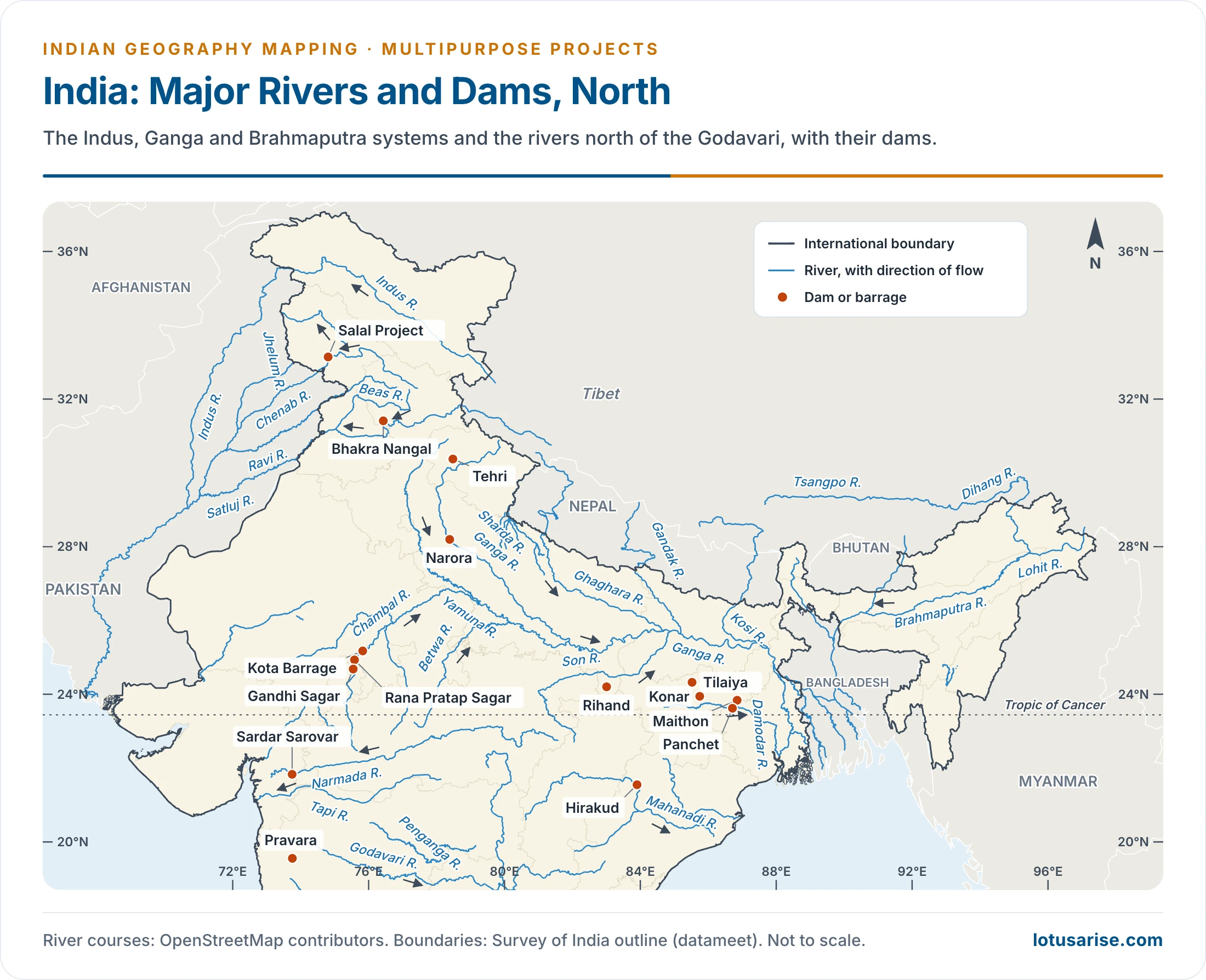
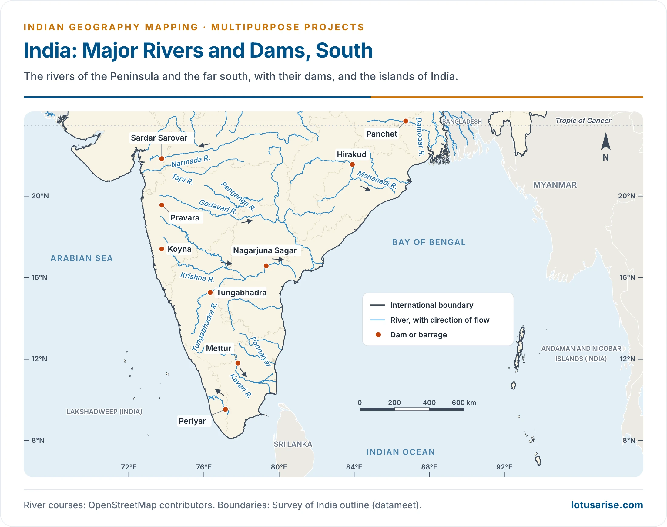
- Kosi Project: an international project under an agreement with Nepal of 1954, revised in 1961. India built it, and both countries share the gains.
- Works: the Hanumannagar barrage in Nepal (1,149 m, 1965), about 270 km of flood embankments, and canals.
- Eastern Kosi Canal (43.5 km): 5.19 lakh hectares around Purnea and Saharsa, later extended.
- Western Kosi Canal (113 km): 3.25 lakh hectares in Darbhanga, plus 12,120 hectares in Nepal.
- A 20 MW power house on the eastern canal shares its output equally with Nepal.
- Gandak Project: run by Bihar and Uttar Pradesh, with Nepal gaining under a 1959 agreement.
- A barrage at Valmikinagar (Bhainsalotan) on the Nepal border, completed in 1966-67, half its length lying in Nepal.
- The Main Western Canal irrigates Saran and the Gorakhpur–Deoria tract. The Main Eastern Canal serves Champaran, Muzaffarpur and Darbhanga.
- A 15 MW power house was gifted to Nepal.
- Tehri Dam: a rock-fill dam on the Bhagirathi where it meets the Bhilangana.
- Conceived in 1949 and begun in 1978, it faced long protest on safety and seismic grounds. Older plans gave 600, then 1,000, then 2,400 MW.
- The complex now totals 2,400 MW, after the 1,000 MW pumped storage plant was fully commissioned on 12 April 2026.
- About 70,000 people lost their homes.
- Govind Ballabh Pant Sagar:
- On the Rihand, behind the Rihand Dam near Pipri, in Sonbhadra district (once part of Mirzapur), Uttar Pradesh.
- Reservoir area: 466 sq km (446 sq km in some lists). It was long called India’s largest man-made reservoir.
- Another dam stands at Obra, 25 km north.
- 934 m long and about 92 m high; 300 MW (6 × 50 MW).
- Power and irrigation reach Madhya Pradesh, Uttar Pradesh and Bihar. Son valley coal, limestone and bauxite belts draw on it.
- Bansagar Project:
- A joint venture of Madhya Pradesh, Uttar Pradesh and Bihar, on the Son on the Rewa–Shahdol road. Cost and water are shared 2:1:1.
- HEP: 405 MW in older lists, 425 MW later.
- Irrigates Sidhi, Satna, Rewa and Shahdol districts.
- Matatila:
- On the Betwa in Lalitpur district of Uttar Pradesh, on the Madhya Pradesh border, built in 1958.
- A joint project of the two States.
- Irrigation: 1.09 lakh hectares in Uttar Pradesh and 1.16 lakh in Madhya Pradesh.
- Rajghat Project:
- Shared by Madhya Pradesh and Uttar Pradesh, on the Betwa near Lalitpur.
- An irrigation-cum-power scheme, known as the Rani Lakshmibai project.
- HEP: 45 MW (3 × 15).
Chambal Valley
- Shared by Madhya Pradesh and Rajasthan, it began in 1954 and has three stages plus the barrage.
- Gandhi Sagar:
- On the Chambal, on the border of the two States. Height 64 m, length 514 m.
- Irrigation: 4.44 lakh hectares.
- HEP: 5 units of 23,000 kW each, making 115 MW.
- Rana Pratap Sagar:
- At Rawatbhata, 56 km below Gandhi Sagar. Height 54 m, length 1,143 m.
- HEP: 4 units of 43,000 kW each, making 172 MW.
- Jawahar Sagar:
- On the Chambal in Rajasthan, about 29 km above Kota city.
- A gravity dam, also called the Kota Dam. Height 45 m, length 548 m.
- HEP: three units of 33,000 kW each, making 99 MW.
- Kota Barrage:
- Less than 1 km from Kota, built in 1960.
- An earthen barrage. Height 36 m, length 600 m.
- Canals on both sides water 4.4 lakh hectares across the two States.
Narmada Valley
- The Narmada Valley Project plans 30 major dams, with 135 medium and 3,000 minor ones. Conceived in 1945-46 and begun in earnest in 1987, it became the country’s most argued-over river scheme.
- An official count of 1993 gave 245 villages and 38,044 families in submergence, against irrigation for 17.92 lakh hectares in Gujarat.
- Indira Sagar (Narmada Sagar):
- The key work of the project, in Khandwa district of Madhya Pradesh.
- Omkareshwar, Maheshwar and Sardar Sarovar draw on its releases.
- Named the country’s largest water storage.
- HEP: 8 × 125 = 1,000 MW. Irrigation: 1.23 lakh hectares.
- Omkareshwar:
- On the Narmada at Mandhata village, in East Nimar (Khandwa) district.
- HEP: 8 × 65 = 520 MW. Irrigation: 1,46,800 hectares.
- Its output rises and falls with water released from Indira Sagar.
- Maheshwar:
- On the Narmada in Madhya Pradesh, below Omkareshwar.
- HEP: 10 × 40 = 400 MW.
- It takes no forest land, and was the first privately financed hydroelectric dam in India.
- Tawa (Chota Tawa in some lists):
- On the Tawa, a left-bank tributary of the Narmada, at Ranipur near Itarsi in Narmadapuram (Hoshangabad) district, where the Tawa meets the Denwa.
- HEP: 13.50 MW. Irrigation: 24,700 hectares in older figures, about 3 lakh hectares in canal accounts.
- The third largest dam of the Narmada Valley Project.
- Sardar Sarovar:
- A project of Madhya Pradesh, Gujarat, Maharashtra and Rajasthan, at Kevadia, now Ekta Nagar, in Narmada district of Gujarat (formerly in the Vadodara tract).
- Height: 121.92 m until 2017. Raising to 138.68 m was permitted in June 2014, and the dam was dedicated on 17 September 2017. The older figure of 163 m measures it from the foundation.
- HEP: 1,450 MW, shared 57% Madhya Pradesh, 27% Maharashtra, 16% Gujarat. Irrigation: around 20 lakh hectares.
- It is often named the world’s second-largest concrete dam by volume.
Mahanadi and Chhattisgarh
- Hirakud:
- On the Mahanadi in Odisha, about 14 km upstream of Sambalpur.
- 61 m high; the main dam is 4,801 m long, among the world’s longest, and 25.8 km with its dykes.
- It was the first stage of a wider plan by A. N. Khosla, with further dams at Tikarpara and Naraj near Cuttack. A weir at Munduli served in place of Naraj.
- HEP: 3.5 lakh kW, now 347.5 MW.
- Irrigation: 1 million hectares, across the delta and the Sambalpur–Bolangir tract.
- Balimela:
- Across the Sileru at Balimela in Malkangiri district of Odisha.
- Both irrigation and HEP (510 MW), jointly with Andhra Pradesh.
- Ravishankar Sagar (Gangrel):
- Across the Mahanadi in Dhamtari district, Chhattisgarh, about 1,830 m long, and described as the State’s longest dam.
- Along with irrigation it produces 10 MW of HEP.
- It supplies water to the Bhilai steel plant.
- Hasdo-Bango (Minimata):
- Across the Hasdeo in Korba district, Chhattisgarh, and described as the State’s highest dam.
- Irrigation: 2,55,000 hectares.
- Three hydro units of 40 MW each, making 120 MW.
Tapi, Godavari and Krishna
- Ukai:
- On the Tapi where it enters Gujarat.
- Power was a leading aim: 300 MW, supplied to Surat and neighbouring cities. Its canals irrigate over 1 lakh hectares.
- Koyna:
- Across the Koyna, a Krishna tributary, in Satara district of Maharashtra. It formed Shivaji Sagar.
- Built mainly for hydropower: 860 MW in older accounts, 1,960 MW now.
- The earthquake of 1967 showed that even the stable Deccan plateau can host strong reservoir-triggered shocks along old faults.
- Nizam Sagar:
- An irrigation and power project on the Manjira near Nizamabad, now in Kamareddy district of Telangana.
- Built from 1923 to 1931 under Mir Osman Ali Khan, the seventh Nizam of Hyderabad.
- A masonry dam with a motorable road, fourteen feet wide, over the top. It supplies Nizamabad and Hyderabad and draws tourists.
- Hussain Sagar:
- An artificial lake in Hyderabad, built by Hazrat Hussain Shah Wali in 1562, under Ibrahim Quli Qutb Shah.
- On a tributary of the Musi, it met the water and irrigation needs of the city.
- A large monolithic statue of the Buddha stands in the middle.
- Nagarjunasagar:
- On the Krishna, with Nalgonda district of Telangana on one bank and Palnadu of Andhra Pradesh on the other. About 125 m high and 1,450 m long, in concrete.
- Jawahar Canal (349 km in older accounts, about 203 km later) and Lal Bahadur Canal (357 km, about 179 km later).
- Irrigation: 7 lakh hectares in older accounts, about 8.6 lakh hectares in canal totals.
- HEP: 100 MW at the first stage, about 816 MW now.
- Tungabhadra:
- A joint venture of Karnataka and Andhra Pradesh at Mallapur, near Hosapete in Vijayanagara district (carved from Ballari, formerly Bellary).
- A straight gravity masonry dam, 50 m high and 2,441 m long.
- Canals irrigate about 5.68 lakh hectares.
- Three power houses: 126 MW, listed at 127 MW later. All 33 crest gates were renewed by June 2026.
- Almatti:
- On the Krishna in Vijayapura (Bijapur) district of Karnataka, the main reservoir of the Upper Krishna Project.
- HEP: 290 MW. 52.25 m high and 1,565.15 m long.
- Linganamakki:
- On the Sharavati about 6 km upstream of Jog Falls, in Shivamogga district.
- 2.4 km long and 193 feet high. HEP: 55 MW.
- Shivanasamudra Dam (1902):
- On the Kaveri in Karnataka, from the British period.
- Designed under Diwan K. Seshadri Iyer.
- Bhadra:
- On the Bhadra, a tributary of the Tungabhadra in the Krishna system, at Lakkavalli in Karnataka.
- A dam and 2 canals, 50 km upstream of where the Bhadra joins the Tungabhadra.
- The Bhadra Wildlife Sanctuary lies nearby.
Kaveri, Periyar and the Far South
- Krishnaraj Sagar:
- An irrigation and power project on the Kaveri near Mysuru (Mysore), in Mandya district of Karnataka.
- The Vrindavan Gardens lie beside the dam.
- Named after Krishnaraja Wodeyar, then ruler of Mysore. Mokshagundam Visvesvaraya was chief engineer.
- Chamaraj Sagar:
- Across the Arkavati, about 35 km from Bengaluru.
- A picnic spot for relaxation and fishing, and a source of water for Bengaluru.
- Periyar Lake:
- Formed behind the Mullaperiyar Dam in Keralam, inside the Periyar National Park, below the meeting of the Mullaiyar and the Periyar.
- Run by Tamil Nadu under a 999-year lease from British times, and disputed between the two States.
- Area: 26 sq km. The dam is 1,200 feet long and 155 feet high.
- Stanley Reservoir:
- Formed by the Mettur Dam in north-western Tamil Nadu.
- Among India’s largest fishing reservoirs.
- Dam length 1,700 m. Installed capacity: 240 MW.
- Bhavani Sagar:
- On the Bhavani in Erode district of Tamil Nadu, among India’s biggest earthen dams.
- It diverts water to the Lower Bhavani Project Canal.
- 32 m high; reservoir capacity 32.80 tmc.
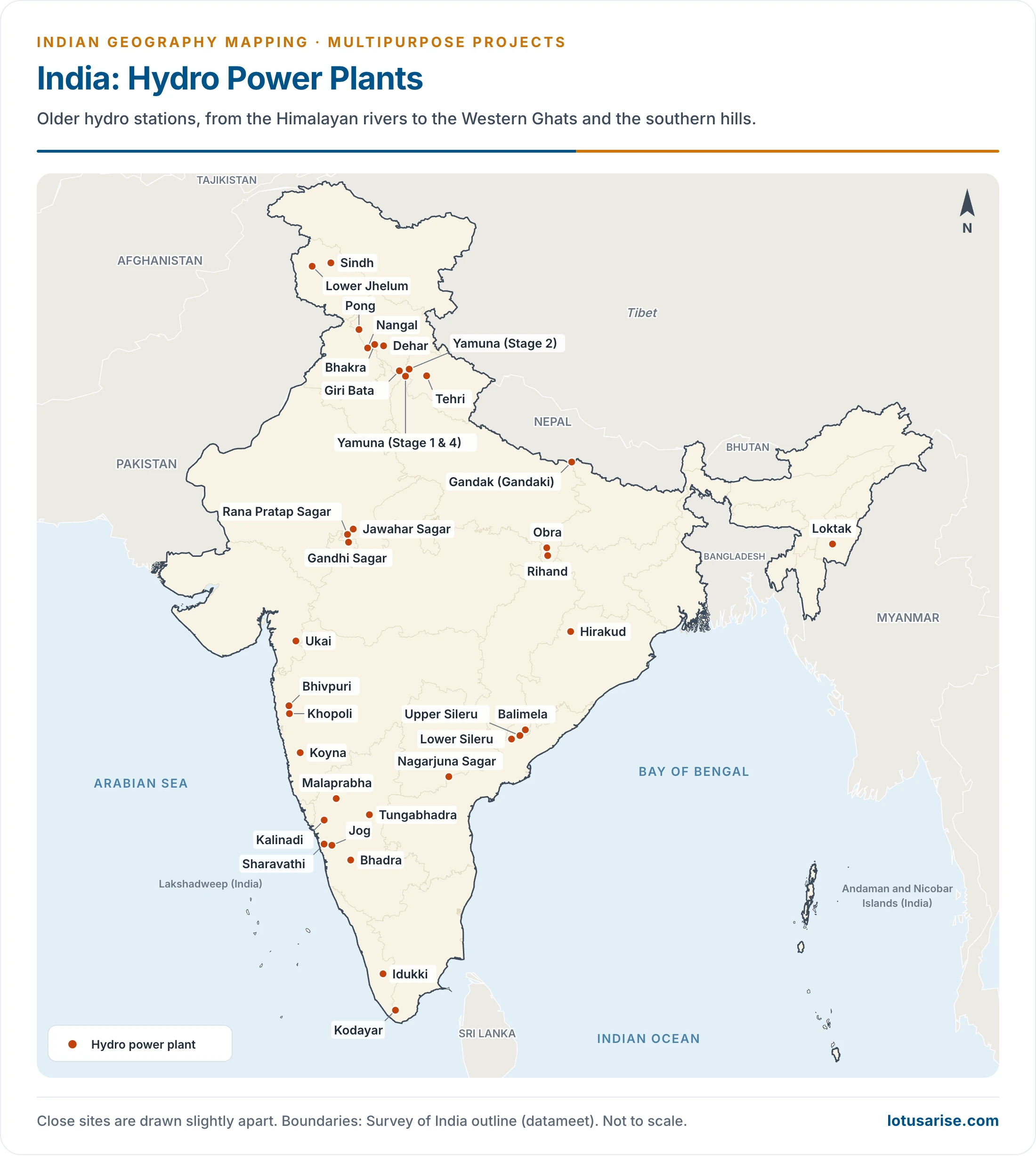
Previous Year Questions
2024Map item: Ekta Nagar2016Map item: Farakka Barrage





Super
thanks
superb
Tulbul project is on jhelum not chenab