Cauvery River
- The Cauvery River (Kaveri) is designated as the ‘Dakshi Bharat ki Ganga’ or ‘the Ganga of the South’.
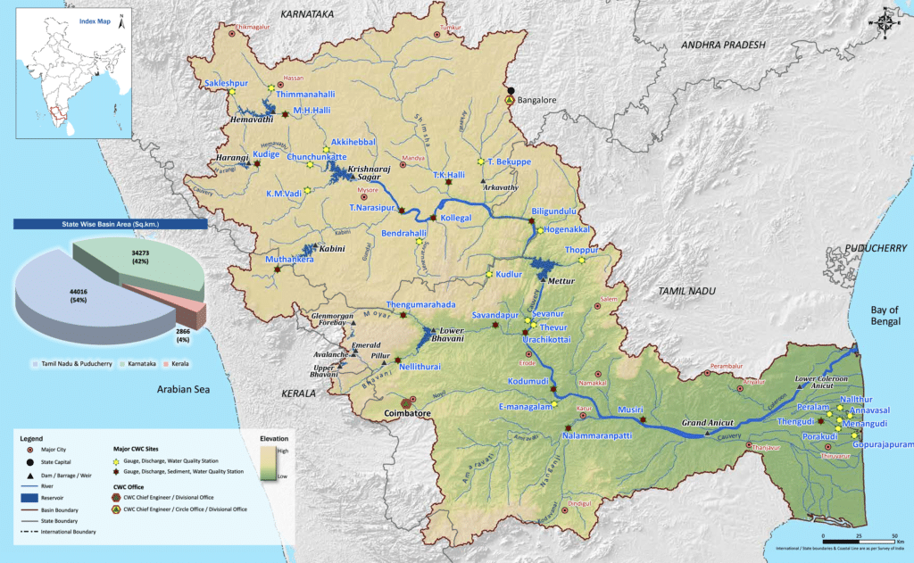
- The Cauvery River rises at an elevation of 1,341 m at Talakaveri on the Brahmagiri range near Cherangala village of Kodagu (Coorg) district of Karnataka.
- The total length of the river from origin to an outfall is 800 km.
- It flows in a southeasterly direction for 705 km through the states of Karnataka and Tamil Nadu and descends the Eastern Ghats in a series of great falls.
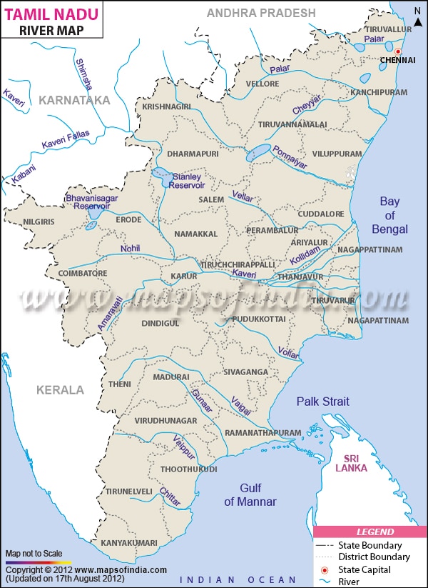
- Before emptying into the Bay of Bengal south of Cuddalore, Tamil Nadu the river breaks into a large number of distributaries forming a wide delta called the “garden of southern India”
- The Cauvery basin extends over states of Tamil Nadu, Karnataka, Kerala, and Union Territory of Puducherry draining an area of 81 thousand Sq.km.
- It is bounded by the Western Ghats on the west, by the Eastern Ghats on the east and the south, and by the ridges separating it from the Krishna basin and Pennar basin on the north.
- The Nilgiris, an offshore of Western ghats, extend Eastwards to the Eastern ghats and divide the basin into two natural and political regions i.e., Karnataka plateau in the North and the Tamil Nadu plateau in the South.
- Physiographically, the basin can be divided into three parts – the Westen Ghats, the Plateau of Mysore, and the Delta.
- The delta area is the most fertile tract in the basin. The principal soil types found in the basin are black soils, red soils, laterites, alluvial soils, forest soils, and mixed soils. Red soils occupy large areas in the basin. Alluvial soils are found in the delta areas.
- The basin in Karnataka receives rainfall mainly from the S-W Monsoon and partially from N-E Monsoon. The basin in Tamil Nadu receives good flows from the North-East Monsoon.
- Its upper catchment area receives rainfall during summer by the south-west monsoon and the lower catchment area during the winter season by the retreating north-east monsoon.
- It is, therefore almost a perennial river with comparatively fewer fluctuations in flow and is very useful for irrigation and hydroelectric power generation.
- Around Sivasamudram are the scenic Sivasamudram Falls, plunging a total of 100 m and reaching a width of 300 m in the rainy season
- The falls supply hydroelectric power to Mysore, Bengaluru, and the Kolar Gold Fields.
- Thus the Cauvery is one of the best-regulated rivers and 90 to 95 percent of its irrigation and power production potential already stands harnessed.
- The river drains into the Bay of Bengal. The major part of the basin is covered with agricultural land accounting to 66.21% of the total area.
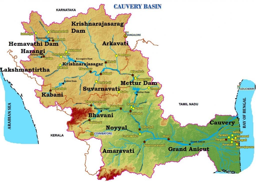
Tributaries of the Cauvery River
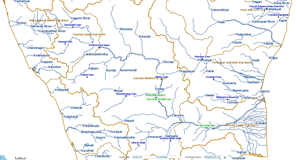
- Left Bank: the Harangi, the Hemavati, the Shimsha, and the Arkavati.
- Right Bank: Lakshmantirtha, the Kabbani, the Suvarnavati, the Bhavani, the Noyil, and the Amaravati joins from the right.
- The river descends from the South Karnataka Plateau to the Tamil Nadu Plains through the Sivasamudram waterfalls (101 m high).
- At Shivanasamudram, the river branches off into two parts and falls through a height of 91 m. in a series of falls and rapids.
- The falls at this point is utilized for power generation by the power station at Shivanasamudram.
- The two branches of the river join after the fall and flow through a wide gorge which is known as ‘Mekedatu’ (Goats leap) and continues its journey to form the boundary between Karnataka and the Tamil Nadu States for a distance of 64 km.
- At Hogennekkal Falls, it takes a Southerly direction and enters the Mettur Reservoir.
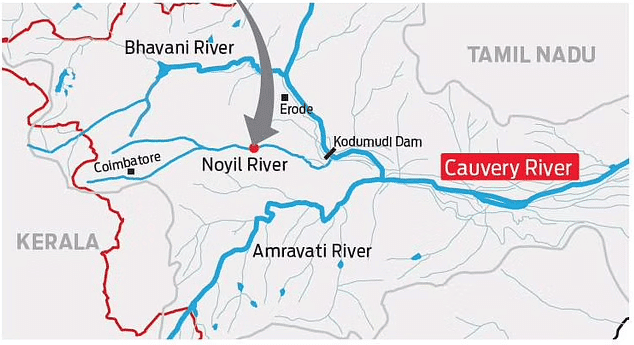
- A tributary called Bhavani joins Cauvery on the Right bank about 45 Kms below Mettur Reservoir. Thereafter it enters the plains of Tamil Nadu.
- Two more tributaries Noyil and Amaravathi join on the right bank and here the river widens with a sandy bed and flows as ‘Akhanda Cauvery’.
- Immediately after crossing Tiruchirapalli district, the river divides into two parts, the Northern branch being called ‘The Coleron’ and Southern branch remains as Cauvery and from here the Cauvery Delta begins.
- After flowing for about 16 Kms, the two branches join again to form ‘Srirangam Island’.
- On the Cauvery branch lies the “Grand Anicut” said to have been constructed by a Chola King in 1st Century A.D.
- Below the Grand Anicut, the Cauvery branch splits into two, Cauvery and Vennar.
- These branches divide and sub-divide into small branches and form a network all over the delta.
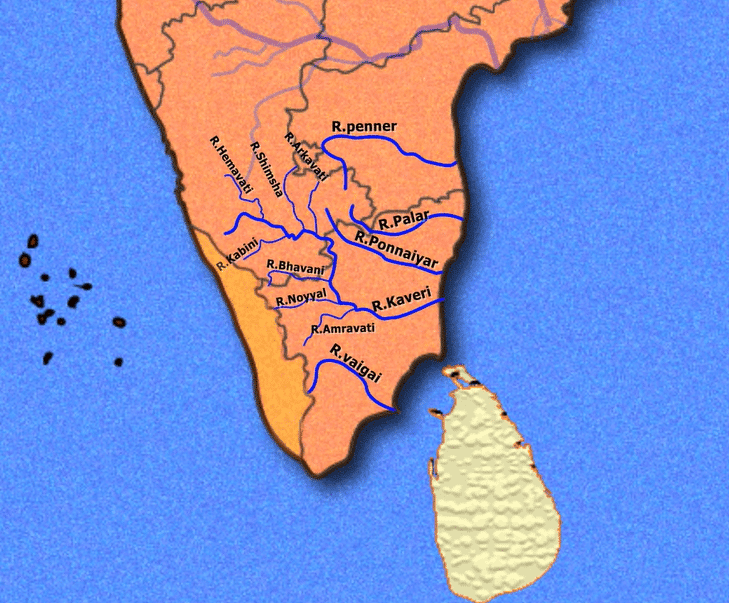
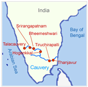
HEMAVATI
- It is an important tributary of the Kaveri River
- It rises from the Western Ghats at an elevation of about 1219m near Ballalarayana Durga in the Chikmagalur District of Karnataka and flows through Chikkamagalooru, Hassan District, and Mysore district before joining the Kaveri near Krishnarajasagara
- It is approximately 245 km long. A large reservoir has been built on the river at Gorur in the Hassan district.
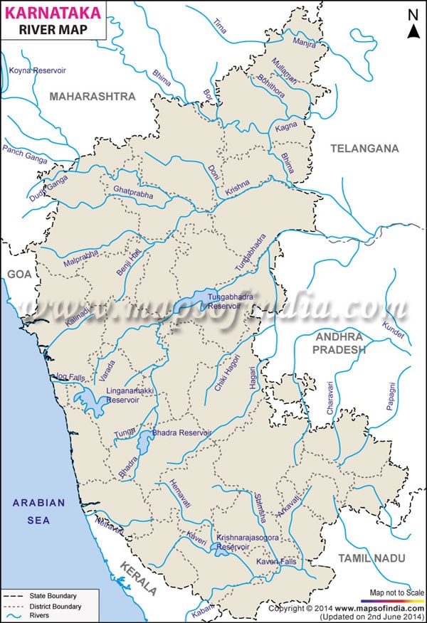
SHIMSHA
- It originates at an altitude of 914 m from the Devarayanadurga hills in the Tumkur District of Karnataka
- It is one of the tributaries of the river Kaveri
- Maddur is a major town that lies on this river
- Markonahalli Dam is a dam built across the river Shimsha in the Kunigal Taluk of Tumkur district
- Shimsha has a waterfall at Shimshapura in Malavalli Taluk
- This is also the location of the Shimsha Hydro Electric Project.
ARKAVATHY RIVER
- This 161 km long river originates at Nandi Hills of Chikkaballapur district of Karnataka
- It is a tributary of the Kaveri River, which it joins at Kanakapura, called Sangama in Kannada, after flowing through Kolar District and Bangalore Rural district
- The river drains into the Chikkarayappanahalli Lake near Kanivenarayanapura
- The picturesque Chunchi waterfall on the Arkavathi River at Sangama near Kanakapura attracts numerous tourists
- The water is taken from two reservoirs built on the river, the Hesaraghatta (or Hesseraggatta), and the Tippagondanahalli Reservoir (or T G Halli).
LAKSHMANA TIRRTHA
- It rises from the Irupu Falls (also Iruppu Falls), located in the Brahmagiri Range in the Kodagu district of Karnataka, bordering the Wayanad district of Kerala.
- It then flows eastward and joins the Kaveri River in the Krishna Raja Sagara Lake.
- Ramathirtha is its major tributary.
KABINI
- Kabini (also called Kabani and Kapila) originates from Pakramthalam hills in Wayanad District of Kerala from the confluence of the Panamaram River and Mananthavady River
- The backwaters of the Kabini reservoir are very rich in wildlife especially in summer when the water level recedes to form rich grassy meadows
- After traversing two kilometers from the confluence of the Panamaram river, Kabini forms an island called Kuruva Island, spreading over 520 acres with diverse flora and fauna.
SUVARNAVATHY
- This 88km long river rises from the Nasrur ghat Range of Karnataka
- It is a tributary of the Kaveri River
- This river has a catchment area of about 1787 sq km
- The Suvarnavathy dam is located across Suvarnavathy River near Attigulipura in the village, Chamarajanagar Taluk at a distance of about 3 km away from the Chikkahole reservoir Project.
NOYYAL RIVER
- Its original name was Kanchinadi but changed later to the name of the place where it drains into the Kaveri River
- It rises from the Vellingiri hills in the Western Ghats in Tamil Nadu and drains into the Kaveri River
- Noyyal joins with river Cauvery at Kodumudi in Erode District. The place is also called Noyyal.
- The 173 km long tributary of the Kaveri River filled 32 tanks
- These interconnecting tanks held the water flowing from the Noyyal.
AMARAVATHI
- Also known as Pournami, this 175km long river begins at the Kerala/Tamil Nadu border at the bottom of Manjampatti Valley between the Annamalai Hills and the Palni hills in Indira Gandhi Wildlife Sanctuary and National Park.
- It descends in a northerly direction through Amaravathi Reservoir and Amaravathi Dam at Amaravathinagar
- This river nourishes the agriculture of Erode District
- The Amaravathi River and its basin, especially in the vicinity of Karur, are heavily used for industrial processing water and waste disposal and as a result, are severely polluted due to a large amount of textile dyeing and bleaching units.
Distributaries of the Cauvery River
Kollidam River ( also called Coleroon River)
- The Kollidam is a river in southeastern India. The Kollidam is the northern distributary of the Kaveri River as it flows through the delta of Thanjavur.
- It splits from the main branch of the Kaveri River at the island of Srirangam and flows eastward into the Bay of Bengal. The distribution system in Kollidam lies at Lower Anaicut which is an island of river Kollidam.
- The town of Chidambaram lies on its banks.
Vennar or Vennaaru River
- The Vennar River or Vennaaru is a river and distributary of the Kaveri River in the Kaveri delta.
- It flows through the Thanjavur, Tiruvarur, and Nagapattinam districts of Tamil Nadu.
- The river begins at the Grand Anaicut at the eastern end of Srirangam Island, where it branches off from the Kaveri. After diverging from the Kaveri, the Vennar flows east.
- Northwest of Thennankudi, at the Thenperambur dam, the Vennar splits into a northern and southern branch. The northern branch becomes the Vettar River, while the southern branch continues east as the Vennar.
- Northwest of Needamangalam, there is another dam across the river, and the river splits again, into three branches. The Pamaniyar and Koraiyar Rivers begin as the two southern branches created by this divergence, while the Vennar continues through the northern branch.
Arasalar River
- The river Arasalar is a river that flows through Tamil Nadu and Pudducherry, and a distributary of Kaveri river which splits into 5 different rivers when it enters into Thanjavur district from Trichy.
- The river takes is course from Thiruvaiyaru of Thanjavur where it branches from Kaveri and emptying itself into the sea of Bay of Bengal at Karaikal, east of Akalanganni.
- Karaikal once served as a river port till the 19th century where the yachts and Marakkalam ships of Karaikal Marakkayar harbored in and, loaded and unloaded the goods towards exports and imports.
- The river is polluted by high concentrations of nitrate and chromium due to the mixing of sewage water into the river stream and industrial activities (in 2013).
Floods in Cauvery Basin
- The Cauvery basin is fan shaped in Karnataka and leaf shaped in Tamil Nadu. The run-off does not drain off quickly because of its shape and therefore no fast raising floods occur in the basin.
Projects on Cauvery River
- During the pre-plan period many projects were completed in this basin which included Krishnarajasagar in Karnataka, Mettur dam and Cauvery delta system in Tamil Nadu.
- Lower Bhavani, Hemavati, Harangi, Kabini are important projects completed duing the plan period.
Industry in Cauvery Basin
- The city of Bangalore is situated just outside this basin.
- Important industries in the basin include the cotton textile industry in Coimbatore and Mysore, cement factories in Coimbatore and Trichinapally, and industries based on minerals and metals.
- The Salem steel plant and many engineering industries in Coimbatore and Trichinapally are also situated in this basin.
Cauvery River Disputes
- Historically, Tamil Nadu used about 602 TMC of the total yield of the river i.e. the available water in a particular year.
- As a result, only about 138 TMC was available for Karnataka until the turn of the 20th century.
- In 1924, Tamil Nadu built the Mettur dam across the Cauvery river.
- Subsequently, Karnataka and Tamil Nadu signed an agreement effective for 50 years.
- Accordingly, Tamil Nadu was allowed to expand its agricultural area by 11 lakh acres from the existing 16 lakh acres.
- Karnataka was authorized to increase its irrigation area from 3 lakh acres to 10 lakh acres.
- The Cauvery River thus primarily served the needs of farmers in Tamil Nadu.
- On completing 50 years, the accord lapsed in 1974.
- Subsequently, Karnataka claimed that the agreement restricted its ability to develop farming activities along the Cauvery basin.
- To make up the lost ground, Karnataka attempted to expand farming activities in the Cauvery basin.
- It started building reservoirs.
- With this, the Cauvery river water sharing issue emerged.
- It is now a major water sharing dispute among Tamil Nadu, Karnataka, Puducherry, and Kerala.
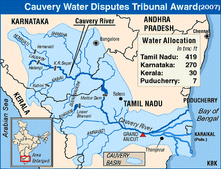
- Tribunal – By Tamil Nadu’s demand, the Union government formed the Cauvery Water Disputes Tribunal (CWDT) in 1990.
- The dispute was adjudicated by the Cauvery Water Disputes Tribunal(CWDT) in 2007.
- Both Tamil Nadu and Karnataka challenged the tribunal’s order.
- The court reserved its order in September 2017.
- ………………………………………………..
Major Inter-State River Disputes
| River (s) | States |
| Ravi and Beas | Punjab, Haryana, Rajasthan |
| Narmada | Madhya Pradesh, Gujarat, Maharashtra, Rajasthan |
| Krishna | Maharashtra, Andhra Pradesh, Karnataka, Telangana |
| Vamsadhara | Andhra Pradesh & Odisha |
| Cauvery | Kerala, Karnataka, Tamil Nadu, and Puducherry |
| Godavari | Maharashtra, Andhra Pradesh, Karnataka, Madhya Pradesh, Odisha |
| Mahanadi | Chhattisgarh, Odisha |
| Mahadayi | Goa, Maharashtra, Karnataka |
| Periyar | Tamil Nadu, Kerala |

Wow wow wow you guys are best in the biss..
Thanks Amit
Wow wow wow…also can anyone pls share a few names of the distributaries of river Kaveri?
I have included the important distributaries of the Cauvery River, Thanks.
Thanks Lotus team ..for this useful &Amazing content..
All river pdf give me sir
I have not compiled it yet.
Have you compiled now if yes then pls provide
Great service you do.
Super information TQ so much lotus team
dakshin ganga is godavari or cauvery
Obsolutly Godavari not Cauvery
Nice tq
just compare the very first and second map. Which one is best? I think 2nd one. first one is hectic…no use.
best notes. done my part of paying and downloading it. thank you Team Lotus Arise.
Amazing work done you guys.
Absolutely stunning compilation! Kudos!
Soo helpful…. thank you @LotusArise
Thanks a lot