

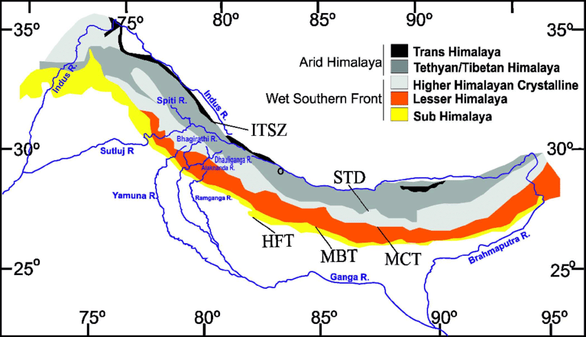
- The Himalaya, also called Himadri, Himavan or Himachal, is a family of parallel and converging ranges, not one chain. From south to north come the Shiwaliks, the Lesser Himalaya, the Greater Himalaya and the Trans-Himalaya, with the Purvanchal as an eastern arm.
- Each range differs in height, rock and age, and the youngest lie furthest south.
- Size and setting:
- The main axis runs over 2,400 km, across more than 22° of longitude, from the Indus gorge to the Brahmaputra gorge.
- Width falls from about 500 km in Kashmir to about 200 km in Arunachal Pradesh. Its total area comes to almost five lakh sq km.
- The Pamir, the “roof of the world”, ties it to the lofty systems of inner Asia, and eastward from that knot it bends as an arc bulging southward.
- The southern limit is sharp, at the foothills along the 300 m contour. The northern limit is vague, merging into the edge of the Tibet Plateau.
- What sets it apart: high altitude, steep gradients, snow-capped summits, deep dissection, youthful drainage, complex geology and rich temperate flora in subtropical latitudes.
Major Physical Divisions of India
- India’s relief is often split into six units, and the desert is sometimes folded into the plains to give five: Himalaya, Great Plain, Peninsular Plateau, Coastal Plains and Islands.
- The Himalayan Mountains
- The Northern Plains
- The Peninsular Plateau
- The Indian Desert
- The Coastal Plains
- The Islands
- A rough Census of 1951 estimate of land by height is still quoted:
| Class | Height (m) | Share of land |
|---|---|---|
| Mountain | Above 2,135 | 10.7% |
| Hilly | 305–2,135 | 18.6% |
| Plateau | 305–915 | 27.7% |
| Plain | Below 305 | 43% |
| Division | What it includes | Character |
|---|---|---|
| Himalaya | Himalaya, Purvanchal; extensions into Arakan Yoma (Myanmar) and the Andaman and Nicobar Islands, which are treated with the islands | Youngest, highly unstable; tectonic movement common |
| Indo-Gangetic Plain | Between the Peninsula and the Himalaya | Most youthful, monotonous (little change or variety), prone to tectonic forces |
| Peninsular Plateau | South and central India, Aravalli, Rajmahal hills, Meghalaya plateau, Kachchh–Kathiawar (Gujarat) | Oldest, most stable landmass |
| Great Indian Desert | Western India | Dry, hot, sandy, with very little vegetation |
| Coastal Plains | Eastern and Western Coastal Plains | River-borne sediment, consolidated; highly stable like the plateau |
| Indian Islands | Lakshadweep; Andaman and Nicobar | See below |
- Lakshadweep: a group of coral atolls with no significant volcanism or tectonic activity in the recent past. They are highly vulnerable to sea-level rise.
- Andaman and Nicobar: a continuation of the Arakan Yoma, tectonically active, with active volcanoes.
Division of the Himalayas
- Shiwaliks or Outer Himalaya
- Lesser or Middle Himalaya
- Greater Himalaya
- Trans-Himalaya or Tibetan Himalaya
- Eastern Hills or Purvanchal, a chain of hills in north-east India
- The Himalaya is also divided on regional lines into Punjab, Kumaon, Nepal and Assam sections, and on geological lines by its thrusts.

| Feature | Shiwaliks | Lesser Himalaya | Greater Himalaya | Trans-Himalaya |
|---|---|---|---|---|
| Other names | Outer Himalaya | Himachal, Middle, Lower | Himadri, Inner, Central | Tibetan Himalaya |
| Height | 600–1,500 m | 3,500–4,500 m | Average 6,100 m | Average 3,000 m in old accounts; ranges far higher |
| Width | 15–50 km | 60–80 km | About 25 km | 40–225 km |
| Main rock | Mio-Pleistocene sand, gravel, conglomerate | Slate, limestone, quartzite, Panjal volcanics | Granite, gneiss, metamorphosed sediment | Tethyan sediment, granite |
| Southern bound | Himalayan Frontal Fault | Main Boundary Thrust | Main Central Thrust | Suture |
Himalayan Ranges
- A series of parallel or converging ranges separated by deep valleys, which gives a densely dissected ridge-and-valley topography.
- Southern slopes are steep; northern slopes are gentler.
- East and west differ. In the east the wall stands up sharply from the Bengal and Oudh lowlands, which puts Kanchenjunga and Everest within sight of the flat country. In the west they climb gradually through several ranges, with the snow peaks 150–200 km from the plain.
- India, Nepal and Bhutan hold most of the ranges. Tibet has part of the northern slopes (the Trans-Himalaya), and the far west reaches Pakistan, Afghanistan and Central Asia.
- Between Tibet and the Ganga Plain, three parallel ranges follow one another.
- Outstanding valleys: the vale of Kashmir and its Karewas, Kangra, Kullu, the Dun valley, Bhagirathi near Gangotri, Mandakini near Kedarnath, and Kathmandu.
Shiwalik Range
- Also known as the Outer Himalaya, it lies between the Great Plains and the Lesser Himalaya.
- Altitude varies from 600 to 1,500 m.
- Length about 2,400 km, between the Potwar Plateau and the Brahmaputra valley.
- Steep southern slopes, gentle northern slopes, which give it a hogback look.
- Width narrows eastward: 50 km in Himachal Pradesh, under 15 km in Arunachal Pradesh.
- An almost unbroken chain of low hills, except for an 80–90 km gap cut by the Tista and Raidak rivers.
- Forest cover thins westward: thick from north-east India to Nepal, sparser beyond, as rainfall falls from east to west along the Shiwaliks and Ganga Plains.
- Southern slopes in Punjab and Himachal Pradesh are almost bare, and seasonal streams called chos dissect them deeply.
- Structure: level-topped scarps, with crests on anticlines and valleys in synclines.
- Rocks: great thicknesses of Mio-Pleistocene sand, gravel and conglomerate, brought by rivers from the higher ranges, then folded, faulted and hardened between Middle Miocene and Lower Pleistocene times.
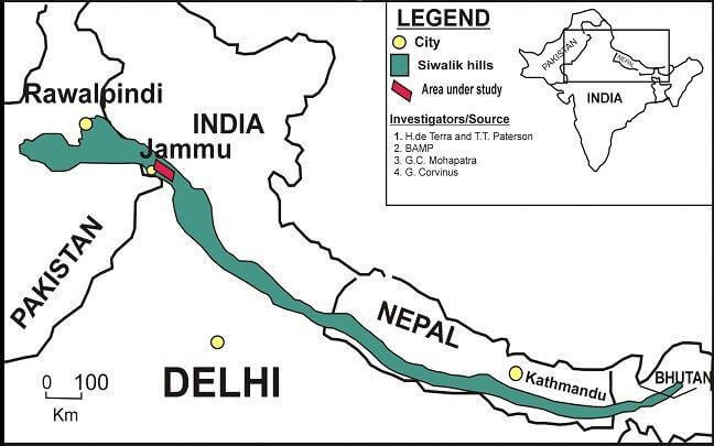
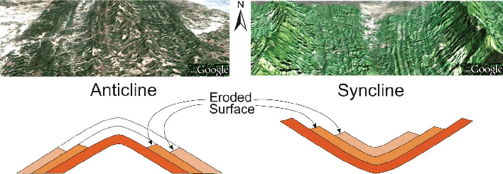
- Local names for the Shiwaliks vary by area:
| Region | Name of the Shiwaliks |
|---|---|
| Jammu region | Jammu Hills |
| Arunachal Pradesh | Dafla, Miri, Abor and Mishmi Hills |
| Uttarakhand, northern Uttar Pradesh | Dhang Range, Dundwa Range |
| Nepal | Churia Ghat Hills |
Formation of the Shiwaliks
- The usual account: sediment shed from the rising higher ranges collected in a foredeep at the mountain front and was later folded and thrust up. They are the last of the ranges to form.
- Age: the group is dated from about 13 million to about 1 million years ago, in Lower, Middle and Upper divisions.
- Explanations differ on what laid the sediment:
- A single great river. Edwin Pascoe and Guy Pilgrim (1919) proposed an Indo-Brahm or Shiwalik river flowing along the whole foot of the mountains, to explain the continuity of the deposits.
- Many rivers. Maharajapuram Sitaram Krishnan and others held that coalescing alluvial fans of rivers leaving the mountains are enough. Current sedimentary work favours piedmont megafans passing into an axial plain.
- Plate setting. The deposits are the molasse of the Himalayan foreland basin, fed by rising thrust sheets and raised along the Himalayan Frontal Fault. This is the framework of current work.
- Uplift of the belt is tied to the frontal thrust, from about 4–2.5 million years ago, and continues.
Formation of Duns (Duars)
- The Shiwaliks are built from conglomerates: sand, stone, silt, gravel and debris.
- In the early stages of deposition, these blocked rivers coming down from the high ranges and ponded short-lived lakes.
- More debris settled in these lakes over time, and the fill settled at their bottoms.
- When the rivers cut through the filled lakes, the water drained away. What remained were flat tracts: duns or doons to the west, duars to the east.
- Dehra Dun in Uttarakhand is the classic case, measuring 75 km by 15–20 km and floored with boulders and clay.
- Other duns: Kotah, Patli, Kothri, Kyarda, Udhampur and Kotli. Older lists also name Chumbi and Chaukhamba, though the first is a high valley between Sikkim and Bhutan and the second is better known as a peak group.
- Current view: many duns are piggyback basins, carried on the moving thrust sheet of the Himalayan Frontal Fault while their rivers cut through the rising front.
Middle or the Lesser Himalaya
- Sandwiched by the Shiwaliks on the south and the Greater Himalaya on the north, and nearly parallel to each.
- Other names: Himachal, Lower Himalaya.
- Size: about 2,400 km long, 60–80 km wide.
- Heights of 3,500–4,500 m are usual, with many summits over 5,050 m under year-round snow.
- Steep, bare southern slopes, where steepness prevents soil from forming, and gentler, forest-covered northern slopes. This gives a hogback look stronger than in the Shiwaliks.
- In Uttarakhand, the range appears as the Mussoorie and Nag Tibba ranges.
- The Mussoorie range averages 2,000–2,600 m and runs 120 km from Mussoorie to Lansdowne.
- The Mahabharat Lekh in southern Nepal continues the Mussoorie Range. Its summits reach 3,000 m, averaging 1,500–2,000 m, with the Kathmandu valley to its north.
- East of the Kosi, the Sapt Kosi, Sikkim, Bhutan, Miri, Abor and Mishmi hills stand for the lower Himalaya.
- The Middle Himalaya is less hostile and friendlier to human contact.
- Most hill resorts lie here: Shimla, Mussoorie, Ranikhet, Nainital, Almora and Darjeeling. The stations mostly sit at 1,500–2,000 m.
| Important range | Region |
|---|---|
| Pir Panjal | Jammu and Kashmir, south of the Kashmir valley |
| Dhaola Dhar | Himachal Pradesh |
| Mussoorie and Nag Tibba | Uttarakhand |
| Mahabharat Lekh | Nepal |
The Pir Panjal Range
- It is the longest and most important range of the Lesser Himalaya.
- It runs from the Jhelum to the upper Beas for 300–400 km.
- It rises to 5,000 m and more and is mostly volcanic rock, the Panjal trap.
- Passes: Pir Panjal (3,480 m), Bidil (4,270 m), Golabghar (3,812 m) and Banihal (2,835 m, also given as 2,832 m).
- Banihal is the route of the Jammu–Srinagar highway and the Jammu–Baramulla railway.
- The road runs under it through the Jawahar Tunnel, opened in December 1956.
- An 11 km rail tunnel between Banihal and Qazigund opened in 2013. The whole Udhampur–Srinagar–Baramulla line was commissioned in June 2025, with the Chenab bridge standing 359 m above the river.
- The Kishanganga, Jhelum and Chenab cut through the range.
- South-east of the Ravi it continues as the Dhaola Dhar, through Dalhousie, Dharmshala and Shimla. This southernmost range of the Middle Himalaya rarely exceeds 4,030 m.
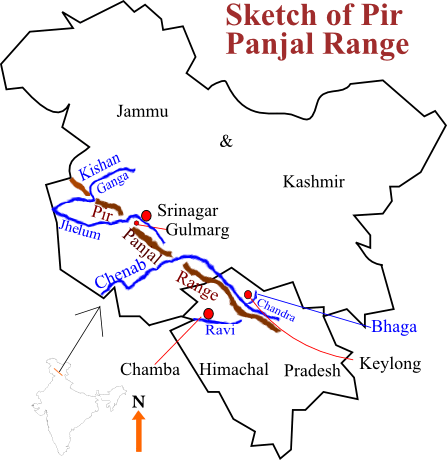
Important Valleys
- The Valley of Kashmir is enclosed by the Zaskar Range and the Pir Panjal.
- Roughly 135 km long, 40 km across at mid-valley, with an area of 4,921 sq km and an average height of 1,585 m.
- Its origin is argued. Darashaw Nosherwan Wadia took it as a synclinal basin between the Pir Panjal and an offshoot of the axial range. Hellmut de Terra saw a recently depressed intermontane basin, with signs of faulting. Most accept that a Pleistocene lake filled it, and the fill was uplifted.
- The synclinal floor carries alluvial, lacustrine (lake), fluvial (river) and glacial deposits.
- The Jhelum meanders over them and leaves through a deep gorge in the Pir Panjal. Kashmir is a basin with very few outlets.
- Karewas are the flat-topped lake and river terraces of this valley, laid from about 4 to 0.4 million years ago as the rising Pir Panjal ponded the drainage. They carry saffron at Pampore, with almond, walnut and apple.
- Kangra Valley in Himachal Pradesh is a strike valley, stretching south of the Beas from the Dhaola Dhar’s foot.
- Kullu Valley is a transverse valley, on the upper Beas. Older accounts put it on the Ravi.
- Kathmandu and Pokhara in Nepal stand on lake deposits.
The Great Himalaya
- Also known as the Inner Himalaya, Central Himalaya or Himadri, it is the northernmost of the main ranges.
- Average elevation 6,100 m; average width about 25 km. It is the loftiest and most continuous range in the world, and lies about 150 km from the plains.
- Rock: the central crystallines (granite and gneiss) overlain by metamorphosed sediment, including limestone.
- Folds are asymmetrical, with a steep south slope and gentle north slope. This gives hogback topography, a long, steep ridge.
- The arc is convex to the south, like the other two ranges.
- It ends abruptly at the syntaxial bends, at Nanga Parbat in the north-west and Namcha Barwa in the north-east.
- It carries the tallest peaks of the world, most under perpetual snow. Fourteen peaks exceed 8,000 m in the Himalaya and Karakoram, and those over 7,000 m run into hundreds.
| Regional name of Mount Everest | Region |
|---|---|
| Sagarmatha (the Goddess of the Sky) | Nepal |
| Chomolungma or Qomolangma (Mother of the World) | China (Tibet) |
- Mount Everest:
- The Great Trigonometrical Survey established it as the world’s highest in 1852, when it was known as Peak XV.
- It was named in 1865 after Sir George Everest, the former Surveyor General of India.
- Heights over time: 8,848 m by the Survey of India, 8,850 m by a GPS survey around 2000, and 8,844.43 m rock height by China in 2005. The agreed official figure is 8,848.86 m (December 2020).
- China says Qing officials mapped the peak in 1717.

| Peak | Older figure (m) | Current (m) |
|---|---|---|
| Mount Everest | 8,850 | 8,848.86 |
| Kanchenjunga | 8,598 | 8,586 |
| Lhotse | 8,501 | 8,516 |
| Makalu | 8,481 | 8,485 |
| Cho Oyu | 8,153 | 8,201 |
| Dhaulagiri | 8,172 | 8,167 |
| Manaslu | 8,156 | 8,163 |
| Annapurna | 8,078 | 8,091 |
| Shisha Pangma (Gosainthan) | 8,013 | 8,027 |
| Namcha Barwa | 7,756 | 7,782 |
- Lower important mountain peaks: Nanda Devi (7,817 m), Kamet (7,756 m), Gurla Mandhata (7,728 m), Trisul (7,140 m) and Badrinath (7,138 m).
Passes in the Greater Himalaya
- The range is hard to cross. Its passes are generally above 4,570 m and snowbound for most of the year. “La” means pass.
| Region | Passes of the Greater Himalaya | Notes |
|---|---|---|
| Jammu and Kashmir, Ladakh | Burzil Pass, Zoji La | Zoji La links Srinagar with Kargil and Leh |
| Himachal Pradesh | Bara Lacha La, Shipki La | Bara Lacha on the Manali–Leh road; Shipki La carries the Hindustan–Tibet Road towards Gartok |
| Uttarakhand | Thaga La, Niti Pass, Lipu Lekh | Lipu Lekh is used by Kailash–Mansarovar pilgrims |
| Sikkim | Nathu La, Jelep La | Nathu La reopened for trade in 2006; Jelep La carried the Kalimpong–Lhasa route |
- Passes outside the main range and elsewhere:
- Rohtang (3,978 m) links Kullu and Lahaul. The Atal Tunnel (9.02 km) now runs beneath it.
- Khardung La near Leh was long called the highest motorable pass. Umling La in eastern Ladakh, at 19,024 ft, entered Guinness World Records in 2021, and the road at Mig La, at about 19,400 ft, went higher in October 2025.
- Sela on the Tawang road is bypassed by the Sela Tunnel, dedicated in March 2024.
- Bom Di La and Bum La in Arunachal Pradesh; Dipher, Kumjawng, Hpungan and Chankan on the Myanmar border.
The Trans-Himalaya
- The ranges just beyond the Great Himalaya. The name Tibetan Himalaya reflects where most of them stand.
- Main ranges: Zaskar, Ladakh, Kailas and Karakoram.
- It stretches about 1,000 km east–west.
- Average elevation is usually given as 3,000 m, though its named ranges stand far higher, as the figures below show.
- Width averages 40 km at each end, about 225 km mid-way.
- Zaskar Range: leaves the Great Himalaya near 80°E and keeps parallel to it.
- Nanga Parbat (8,126 m) is a peak massif rather than a range. It is taken as the north-western culmination of the Zaskar, with the Deosai Mountains adjoining it.
- Ladakh Range: north of the Zaskar and parallel to it, about 300 km long, averaging 5,800 m.
- Only a few peaks exceed 6,000 m. Across the Indus, the Rakaposhi–Haramosh ranges prolong it north-westward.
- Kailas Range (Gangdise in Chinese): an offshoot of the Ladakh Range in western Tibet, averaging 5,500–6,000 m and about 30 km wide.
- Mount Kailas (6,714 m) is its highest peak, and the Indus rises on its northern slopes.
- Great Karakoram Range, also called Krishnagiri: the northernmost Trans-Himalayan range in India.
- The frontier with Afghanistan and China follows it, and it divides the drainage of India from that of Turkistan.
- Length about 800 km eastward from the Pamir; width 120–140 km; crest rarely under 5,500 m.
- Some of the largest glaciers beyond the polar regions lie here.
- Karakoram peaks:
- K2 (8,611 m), also Godwin-Austen or Qogir, is the second highest in the world and the highest in the Indian Union.
- Gasherbrum I or Hidden Peak (8,080 m, older 8,068), Broad Peak (8,051 m, older 8,047) and Gasherbrum II (8,034 m, older 8,035).
- Another 19 peaks pass 7,600 m.
- Ladakh Plateau: north-east of the Karakoram, with a mean height above 5,000 m, India’s highest plateau.
- It is cut into plains and mountains: Soda Plains, Aksai Chin, Lingzi Tang, Depsang Plains and Chang Chenmo. Aksai Chin is Indian territory under Chinese occupation.
Purvanchal or Eastern Hills
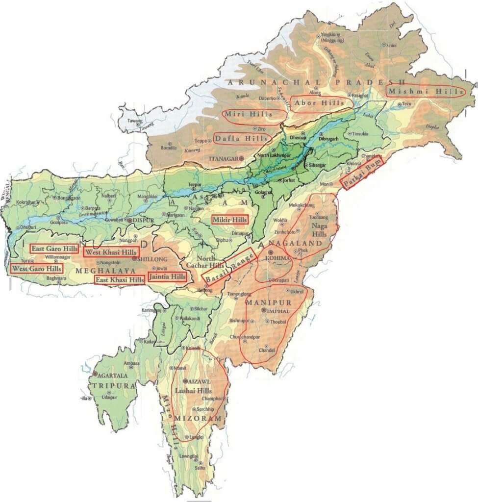
- The Eastern Hills or Purvanchal are the southward extensions of the Himalaya along India’s north-eastern edge.
- At the Dihang gorge the Himalaya makes a sudden southward turn and forms a series of comparatively low hills, convex to the west.
- They run along the India–Myanmar border, from Arunachal Pradesh to Mizoram.
- Lower in relief and different in form from the Himalaya, they come from the same orogeny.
- Patkai Bum: the Arunachal–Myanmar boundary, of strong sandstone, at 2,000–3,000 m. It merges into the Naga Hills, highest at Saramati (3,826 m).
- Patkai Bum and the Naga Hills divide the drainage of India from that of Myanmar.
- Kohima hills: to the west, of sandstone and slate, very rough.
- Manipur hills: south of the Naga Hills, generally under 2,500 m, on the Manipur–Myanmar boundary.
- Barail Range: separates the Naga and Manipur hills.
- It swings west into the Jaintia, Khasi and Garo hills, an eastward continuation of the Peninsular block. The Ganga–Brahmaputra lowland separates them from the main block.
- Mizo Hills (formerly Lushai Hills): south of Manipur, under 1,500 m, highest at the Blue Mountain (2,157 m).
- Elevation falls from north to south, but rough ground, dense forest and swift streams make the region forbidding.
- The trend continues south through the Myanmar ranges to the Andaman and Nicobar Islands and the Indonesian arc.
Significance of the Himalaya
- Climate: the wall intercepts the summer monsoon and holds back cold air from Central Asia. Without it much of India would be desert with severe winters. It also splits the jet stream, which matters to the monsoon.
- Defence: a long-standing barrier, less decisive since 1962 but still important.
- Rivers: nearly all the great rivers rise here, and snowmelt keeps them perennial.
- Fertile soil: the alluvium built the plain. Estimates of silt are about 19 lakh tonnes a day for the Ganga and 10 lakh tonnes for the Indus, with more for the Brahmaputra.
- Hydroelectricity: many natural and dam sites; much potential remains unused.
- Forests: a succession from tropical to alpine, with fuelwood, raw material, medicinal plants and pasture.
- Agriculture: limited, on terraces. Rice, wheat, maize, potato, tobacco and ginger, with tea and fruit such as apple, pear, walnut and apricot.
- Tourism and pilgrimage: summer and winter resorts; shrines including Kailas, Amarnath, Badrinath, Kedarnath, Vaishno Devi, Gangotri and Yamunotri.
- Minerals: oil potential in Tertiary rocks, Kashmir coal, and copper, lead, zinc, nickel, cobalt, antimony, tungsten, gold, silver, limestone, gypsum and magnesite at over 100 places, mostly hard to work.
Previous Year Questions
2024Discuss the basis of the various explanations for the formation of the Shiwalik.2013Explain the topographical and structural characteristics of the Siwalik Range.2010Explain Himalayan Orogeny and illustrate how the process has affected the geomorphic characteristics of Macro divisions of Himalayas.2007Explain the different views put forth about the origin of Himalayas and divide Himalayas into vertical divisions.1995Draw a sketch-map in your answer book to delineate the main physiographic regions of India and provide a reasoned account of the relief and structure of the Himalayan region.1988Explain the salient features of the structure, relief and drainage of the Himalayas.





Please initiate geography optional answer writing practice as well.
And, the test series we’ve in the market, are costly and not affordable for many of the aspirants. Please come up with some test series at a lower price as well.
Rickta, I have very limited time, so please use previous year’s question papers for answer writing practice.
Plssssssss make notes for gs 2 governance and international relations paper it will be more helpful
Thank you sir , for providing good content and easy way to understand the topic.
sir could you please check the list of name of shiwaliks and region ,,i think the sequence have changed
Good Article
thnks a lot sir for providing such a quality notes. Your notes are very helpful for quick revision.
May god bless u with good health nd happiness 🙏
EXCELLENT ONE
i glad that i, stumbled into this great website.
Thanks for the quality content.
Sir plz reply me ….pehle bhi maine yeh question pucha tha …kya yeh sab note padna sufficient hai…bcoz mai sojti hun book se jyada apke lotusarise ke note ko jyada atcha hai time bhi waste nahi hota
Sir, zanskar is extension of greater himalayas , this is not a range of trand himalayas as mentioned by soo many authors, plzz kindly commit on my confusion, thanks for such immensively best content,
Karakoram, Ladakh, Zaskar and Kailash are parts of Trans Himalayas.
Indrasan is the highest peak of the Pir Panjal Range
I really love this every maps with lotusarise ,thanks it’s helpful 🤝
there are a few mistakes in this page i.e nanga parbat is not a part of zaskar range. its w of great himalayas
I dont know who are you, but a gem for student lyk us thnq soooo much.
Most Welcome, Keep Reading
Infinite satisfaction, most clear topic first time I feel a complete topic lots of thaks