

- Endogenic (endogenetic) forces are the internal forces of the Earth: stresses generated inside the earth that move, raise, lower, bend, break and melt the crust.
- Their work shows up as uplift and subsidence, folding and faulting, earthquakes and volcanism.
- They are land-building (constructive) forces: they create the vertical irregularities of the surface, such as mountains, plateaus, basins and rift valleys.
- The exogenic forces (weathering, mass wasting, erosion and deposition) work continuously against them, wearing that relief down.
- Endogenic forces work on two time-scales: slow, long-period movements (diastrophism) that no one sees in a lifetime, and sudden, short-period events (earthquakes, eruptions) that happen in seconds to hours.
Geomorphic Processes and Endogenic Forces
Geomorphic Processes and Agents
- Geomorphic processes are the physical and chemical processes that create and modify landforms on the Earth’s surface.
- Endogenic processes: diastrophism and volcanism, driven by energy from within the Earth.
- Exogenic processes: weathering, mass wasting, erosion and deposition, driven by solar energy and gravity.
- A geomorphic agent is a mobile medium that removes, transports and deposits earth materials: running water, glaciers, wind, waves and currents, and groundwater.
- Endogenic forces are not agents; they supply the relief on which the agents work.
| Basis | Endogenic forces | Exogenic forces |
|---|---|---|
| Origin | Inside the Earth | Atmosphere and surface |
| Energy | Radiogenic and primordial heat | Solar energy and gravity |
| Role | Build relief (constructive) | Level relief (destructive, planation) |
| Speed | Mostly slow; sometimes sudden | Continuous, gradual |
| Examples | Folding, faulting, volcanism | Weathering, erosion, deposition |
Source of Endogenic Energy
- The driving energy is Earth’s internal heat, which escapes at about 44–47 TW of global heat flow.
- Radiogenic heat: decay of uranium-238, thorium-232 and potassium-40 supplies roughly half of it, as geoneutrino measurements now confirm.
- Primordial heat: the rest is heat left over from the accretion of the planet and the sinking of iron to form the core.
- Tidal friction adds only a minor share.
- This heat sets up geothermal gradients, mantle convection and plate motion, which in turn cause diastrophism and volcanism in the lithosphere.
- Differential expansion and contraction of rocks under changing temperature also generates stress.
- Most of this stress concentrates at plate margins, where plates are pushed and pulled (ridge push, slab pull), so the margins are the most unstable belts.
Classification of Endogenic Forces
- By intensity and speed, endogenic forces are grouped into diastrophic forces (slow) and sudden forces (rapid).
- By direction, the diastrophic forces are further split into vertical (epeirogenic) and horizontal (orogenic) movements.
| Group | Type | Direction | Speed | Main results |
|---|---|---|---|---|
| Diastrophic | Epeirogenic (continent-forming) | Vertical, radial | Very slow | Uplift, subsidence, emergence, submergence, broad warping |
| Diastrophic | Orogenic (mountain-forming) | Horizontal, tangential | Slow | Folds, faults, nappes, rift valleys, fold mountains |
| Sudden | Earthquakes | Any | Seconds | Faults, scarps, uplift or subsidence, lakes, landslides |
| Sudden | Volcanism | Upward (magma) | Hours to years | Cones, lava plateaus, calderas, intrusions |
Diastrophic Forces
- Diastrophism (Greek diastrophē, distortion) is the general term for slow bending, folding, warping and fracturing of the crust.
- It covers all processes that move, elevate or build up portions of the crust.
- Warping means bending the crust gently up or down over a large area, without sharp folds.
- Its effects become visible only over thousands to millions of years, but it builds meso- and macro-scale relief: mountains, plateaus, plains, lake basins and major faults.
- The terms orogeny and epeirogeny were set apart by Grove Karl Gilbert (1890).
- Orogeny is the mountain-building process; epeirogeny is the continent-building process.
- Folding, faulting and plate movement cause pressure, volume and temperature (PVT) changes in rocks, which in turn induce metamorphism.
Epeirogenic Movements
- Epeirogeny (Greek epeiros, continent) is the vertical uplift or subsidence of large parts of the crust.
- It produces long-wavelength undulations with little or no folding, so the rock strata stay nearly horizontal.
- It acts along the radius of the Earth, so it is also called a radial movement; the movement is either away from the centre (uplift) or towards it (subsidence).
- It affects the broad, stable interiors of continents, the cratons, as well as coastal belts.
- Causes now recognised: isostatic adjustment after loading or unloading, heating or cooling of the lithosphere, and mantle upwelling or downwelling (dynamic topography).
- Post-glacial rebound is the clearest live example: the land around the northern Gulf of Bothnia is still rising by up to about 1 cm a year since its ice sheet melted.
Uplift and Emergence
- Upward movement raises either a whole continent or part of it, or only its coastal land; coastal uplift is called emergence.
- Evidence: raised beaches, elevated wave-cut terraces and platforms, sea caves and marine fossil beds above present sea level.
- Indian examples:
- Raised beaches stand several metres above present sea level along the Kathiawar, Nellore and Tirunelveli coasts.
- In the 2004 Sumatra–Andaman earthquake, the northern and western Andaman Islands rose while the southern and eastern parts sank.
Subsidence and Submergence
- Downward movement either lowers an inland area (subsidence) or carries coastal land below sea level (submergence).
- Evidence: submerged forests, drowned valleys, peat and lignite beds below sea level, and drowned buildings.
- Indian examples:
- Rann of Kachchh (1819): the earthquake raised the Allah Bund, a ridge about 6 m high and some 80 km long, while the land to its south, with Sindri Fort, sank and was flooded.
- Peat and lignite beds below sea level in the Tirunelveli coast and the Sundarbans.
- Submerged forests found below low-water mark on the east side of Bombay island and on the Tirunelveli coast.
- The shallow Gulf of Mannar and Palk Strait were drowned in geologically recent times; submerged structures lie off Mahabalipuram.
- Indira Point at the southern tip of Great Nicobar subsided about 4.25 m in the 2004 earthquake.
Reading the Evidence
- A shoreline can shift for reasons other than crustal movement, so each case needs checking.
- Eustatic sea-level change: sea level has risen by over 100 m since the last glacial maximum, so many submerged forests and drowned valleys record a rising sea, not a sinking land.
- Delta growth: old ports now inland, such as Korkai (about 6 km inland on the Tamiraparani delta), Kaveripattinam in the Kaveri delta and Coringa near the Godavari mouth, were stranded mainly by river deposition pushing the coast seaward.
- Uplift is proven only where dated marine features stand above the sea level of their time, or where the movement is measured (tide gauges, GPS, co-seismic surveys).
Orogenic Movements
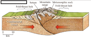
- Orogeny (Greek oros, mountain) is caused by horizontal forces acting tangentially to the Earth’s surface, so they are also called tangential forces.
- They act in long, narrow belts, deform the crust severely, and are today explained by plate convergence and divergence.
- In the resulting mountains, structural units are often hard to recognise because of intense folding and thrusting.
- Horizontal forces work in two ways:
| Force | Direction | Also called | Crustal response | Main structures |
|---|---|---|---|---|
| Tensional | Away from each other | Divergent | Crustal fracture | Cracks, joints, normal faults, rift valleys, horsts |
| Compressional | Towards each other | Convergent | Crustal bending, then fracture | Warps, folds, reverse and thrust faults, nappes |
- Structures in brief:
- Warping: broad upwarping (arch) and downwarping (basin) of large areas under compression.
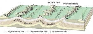
- Folds: wave-like bends; the up-arched part is an anticline, the trough a syncline; a large anticline or syncline carrying many minor folds is an anticlinorium or synclinorium.
- Dip and strike: dip is the angle and direction of a bed’s inclination from the horizontal; strike is the direction of a horizontal line on the bed, always at right angles to the dip.
- Joints and faults: a joint is a fracture with no appreciable movement; a fault is a fracture along which the blocks are displaced.
- Nappes: when compression overturns a recumbent fold, breaks it and thrusts it kilometres forward over younger rocks; the Alps carry stacked Helvetic, Penninic and Austroalpine nappes, and nappes are mapped across the Kashmir, Simla, Garhwal and Kumaon Himalaya.
- Rift valleys (grabens) and horsts: a graben is a long block dropped between parallel normal faults; a horst is an upstanding block.
| Fold type | Limbs |
|---|---|
| Symmetrical | Equal dips, open |
| Asymmetrical | Unequal dips and lengths |
| Monoclinal | One gentle limb, one very steep limb |
| Isoclinal | Limbs parallel, not horizontal |
| Recumbent | Limbs parallel and nearly horizontal |
| Overturned | One limb pushed past the vertical |
| Plunging | Axis tilted from the horizontal |
| Fan | Broad fold with many minor folds |
| Open / Closed | Inter-limb angle obtuse / acute |
| Fault type | Movement | Stress | Example |
|---|---|---|---|
| Normal | Hanging wall down the dip | Tension | Rhine graben margins, East African Rift |
| Reverse / thrust | Hanging wall up the dip | Compression | Main Central and Main Boundary Thrusts, Himalaya |
| Strike-slip (dextral / sinistral) | Blocks slide sideways | Shear | San Andreas; Sagaing (Myanmar) |
| Oblique-slip | Dip-slip plus strike-slip | Mixed | Many active faults |
| Step | Parallel faults downthrown the same way | Tension | Rift shoulders |
Origin of Rift Valleys
- Tensional (keystone) hypothesis: tension opens two parallel faults and the middle block drops like the keystone of an arch.
- Early objection: there is no hollow beneath the crust, so the block must displace the substratum, and not all rifts are volcanic.
- Compressional hypothesis: Edward James Wayland (Lake Albert–Ruwenzori), Bailey Willis (Dead Sea) and Edward Crisp Bullard (East African gravity surveys, 1930s) held that the side blocks are thrust up and hold the central block down.
- Bullard linked the rift’s width to its depth and the density of the substratum.
- Current view: seismic, gravity and GPS evidence show that rifts form by crustal extension over rising hot mantle; the East African Rift is a continental divergent boundary, and mid-ocean ridges carry axial rift valleys.
- Indian examples: the Narmada and Tapi valleys and the Damodar and Son Gondwana basins are treated as graben or rift structures.
Sudden Forces
- Sudden movements cause large deformation in seconds to hours; earthquakes and eruptions become disasters where population is dense.
- They are the quick release of stress or magma built up over long periods; only their surface effect is sudden.
- They are concentrated at plate margins, but strong intraplate events also occur, such as Kachchh (1819, 2001) and Latur (1993).
- They are also constructive: eruptions build cones and lava plateaus, earthquakes create faults, scarps and lakes.
- Earthquakes and eruptions belong to the class of extreme events: rare, high-magnitude happenings, along with floods, droughts and cyclones, whose effects are felt within minutes to hours.
Earthquakes
- An earthquake is the sudden release of stress stored in rocks, which radiates as seismic waves when a fault slips (elastic rebound).
- Geomorphic effects:
- Uplift and subsidence: the Valparaíso (Chile) earthquake of 1822 raised the coast by about 1.2 m; the 2004 earthquake lifted parts of the Andamans and drowned parts of the Nicobars.
- Surface rupture: the 2023 Türkiye–Syria earthquakes offset the East Anatolian Fault by several metres, and the 2025 Myanmar earthquake slipped the Sagaing Fault by up to about 6 m sideways along a rupture of some 500 km.
- Changes in relief and drainage: new scarps, dammed or diverted rivers, and lakes such as the one formed behind the Allah Bund.
- Landslides, rockfalls and liquefaction, especially in the Himalaya.
- Tsunamis (Japanese for “harbour wave”): sea waves set off by sea-floor displacement, which reshape shorelines.
Volcanism
- Volcanism covers the movement of molten rock (magma) towards or onto the surface and the intrusive and extrusive landforms it builds.
- A volcano forms where magma escapes through a vent or fissure with gases and pyroclastic material; the form depends on the lava’s silica content, viscosity and gas content.
- Volcanic gases: mainly water vapour, with carbon dioxide, sulphur dioxide, hydrogen sulphide and hydrogen chloride.
- Pyroclastic flows are dense, ground-hugging currents of hot gas, ash and rock fragments, usually 200–700°C and faster than 80 km/h, which destroy everything in their path.
- Landforms:
- Extrusive: cones, composite volcanoes, calderas and fissure-fed lava plateaus such as the Deccan Traps (about 66 million years old) and the Columbia Plateau.
- Intrusive: batholiths, laccoliths, lopoliths, sills and dykes.
- Indian example: Barren Island in the Andaman Sea, India’s only confirmed active volcano, has been in a near-continuous eruptive phase since 2022; Narcondam is dormant.
Endogenic Forces and Landform Evolution
| Endogenic process | Landforms | Examples |
|---|---|---|
| Epeirogenic uplift | Plateaus, raised beaches, uplifted plains | Kathiawar raised beaches; Fennoscandia |
| Epeirogenic subsidence | Basins, drowned coasts, submerged forests | Sundarbans, Gulf of Mannar |
| Compression (folding, thrusting) | Fold mountains, nappes, intermontane basins | Himalaya, Alps |
| Tension (faulting) | Rift valleys, block mountains, fault scarps | Narmada–Tapi; Vosges and Black Forest horsts |
| Earthquakes | Scarps, uplifted or drowned coasts, quake lakes | Allah Bund; Andaman–Nicobar 2004 |
| Volcanism | Cones, calderas, lava plateaus, intrusions | Deccan Traps, Barren Island |
- Endogenic and exogenic forces act together: relief at any moment is the balance between the rate of uplift and the rate of denudation.
- This was the core of Walther Penck’s (1924) model of landform development, in which slope form reflects whether uplift is waxing, steady or waning.
- William Morris Davis (1899) instead assumed a short, rapid uplift followed by long stillstand, an assumption active tectonics has since undermined.
- Rates are now measured, not inferred.
- The Indian Plate converges with Eurasia at about 4 cm a year, and about 2 cm a year of it is taken up across the Himalaya, stored as strain on the Main Himalayan Thrust and released in great earthquakes.
- GPS, InSAR and satellite gravity track uplift, subsidence and co-seismic displacement in near real time.
- Current view: the old division into vertical (epeirogenic) and horizontal (orogenic) movements survives as a descriptive scheme, but both are now explained within plate tectonics and mantle dynamics.
Previous Year Questions
2004Describe the landforms which are products of endogenetic forces.1998Write short note: Geomorphic processes.1993Discuss, with examples, the influence of vulcanism and diastrophism on the evolution of landscape.1992Write short note: Classification of Earth Movements.





Very nice article with good examples
I think the example of subsidence caused in Rann of Kutch in 1819, should be a part of sudden movements, since it was caused by earthquake and should not come under diastrophism, which is a gradual process. Correct me, if wrong.
sweet