- The American school of geography is the body of geographical thought built in the United States from the explorations and surveys of the 19th century, through the university departments founded after 1878, to the spatial science and critical geographies of today.
- It began under strong European influence. Arnold Guyot brought Carl Ritter’s ideas, and Ellen Churchill Semple brought Friedrich Ratzel’s. Through William Morris Davis it soon developed a character of its own: field observation, evolutionary models and a habit of lively methodological debate.
- Its main phases ran from environmental determinism, through human ecology, chorology and the cultural landscape, to the regional paradigm of Richard Hartshorne. After 1953 came the quantitative revolution, and then the behavioural, radical, humanistic and postmodern approaches.
Growth of Geography in the United States

Exploration and Early Foundations
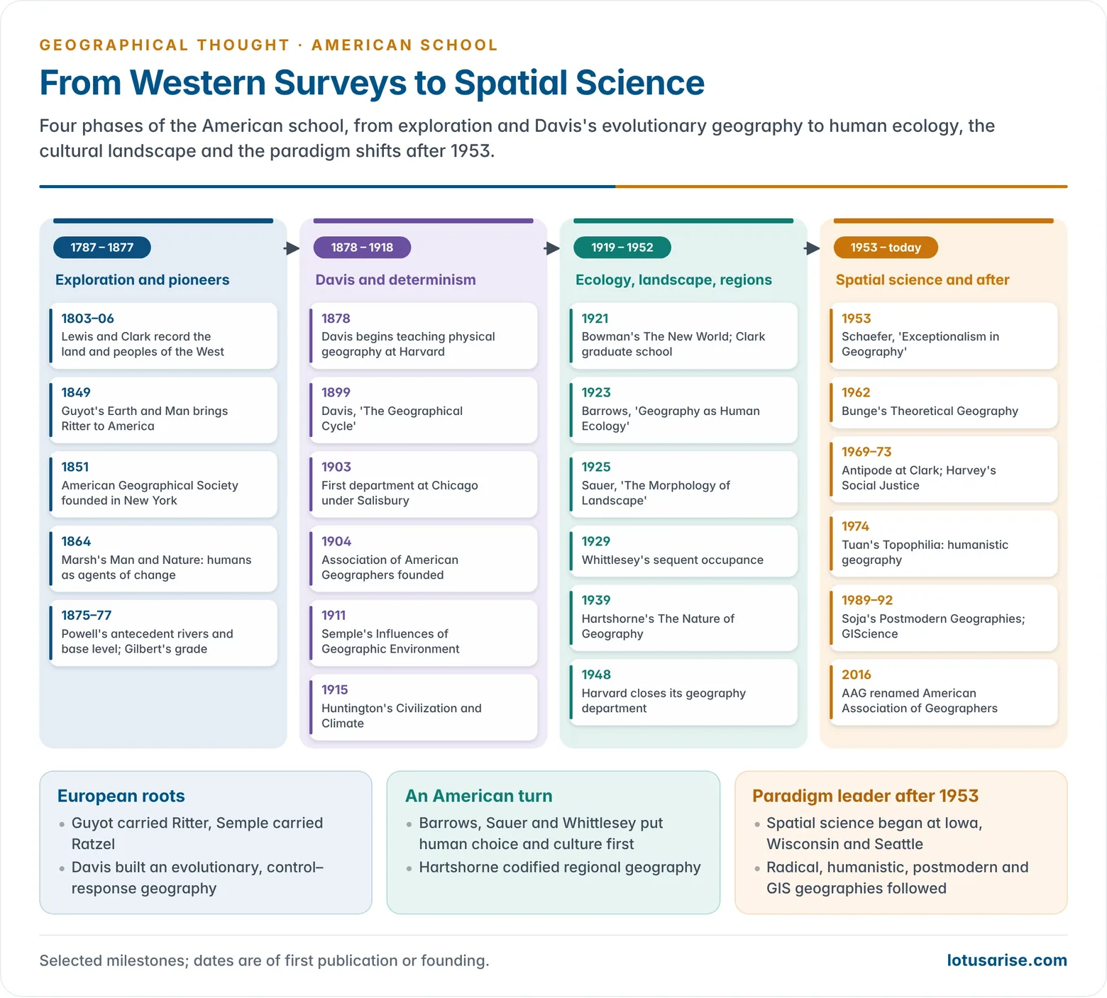
- Thomas Jefferson’s Notes on the State of Virginia (1787) and the Lewis and Clark expedition (1803–06), which he sponsored, began a tradition of recording land, resources and peoples on the westward frontier.
- Matthew Fontaine Maury (1806–1873), a naval officer, mapped winds and currents and published The Physical Geography of the Sea (1855).
- Surveys of the West (1860s–1870s) under Ferdinand Hayden, Clarence King, George Wheeler and John Wesley Powell combined mapping with land classification.
- John Wesley Powell coined the term antecedent river and set out the concept of base level. His Report on the Lands of the Arid Region (1878) warned that the dry West could not be settled like the humid East.
- Grove Karl Gilbert developed the concept of grade, the balance between slope, discharge and load (1877). Davis later built both ideas into his cycle.
- Louis Agassiz at Harvard (from 1848) taught a generation to read glacial landforms. His pupil Nathaniel Southgate Shaler taught Davis to see man and his works as part of the landscape.
Pioneers: Marsh and Guyot
- George Perkins Marsh (1801–1882), a Vermont lawyer, congressman and diplomat with no training in geography, wrote Man and Nature; or, Physical Geography as Modified by Human Action (1864).
- Drawing on what he saw in the Mediterranean lands, he showed how deforestation, soil erosion and drainage degraded the earth. He argued that human action could disturb the balance of nature.
- The book reversed the usual question. It asked how humans change nature, not how nature shapes humans, and it became a founding text of the conservation movement.
- It introduced American readers to the ideas of Humboldt, Ritter and Mary Somerville. Marsh revised it as The Earth as Modified by Human Action (1874) while serving as United States minister to Italy.
- Arnold Henry Guyot (1807–1884), a Swiss pupil of Ritter, came to the United States in 1848. His Lowell Institute lectures were published as Earth and Man (1849).
- He was professor of physical geography and geology at Princeton from 1854 until his death. He was the first holder of such a chair in the country.
- He carried over Ritter’s teleological view: the continents were designed as the home and stage of humanity. He also organised meteorological observation that led towards a national weather service.
- His school textbooks shaped attitudes for a generation, but his teleology was outdated by Darwinism by the time he died.
Professionalisation
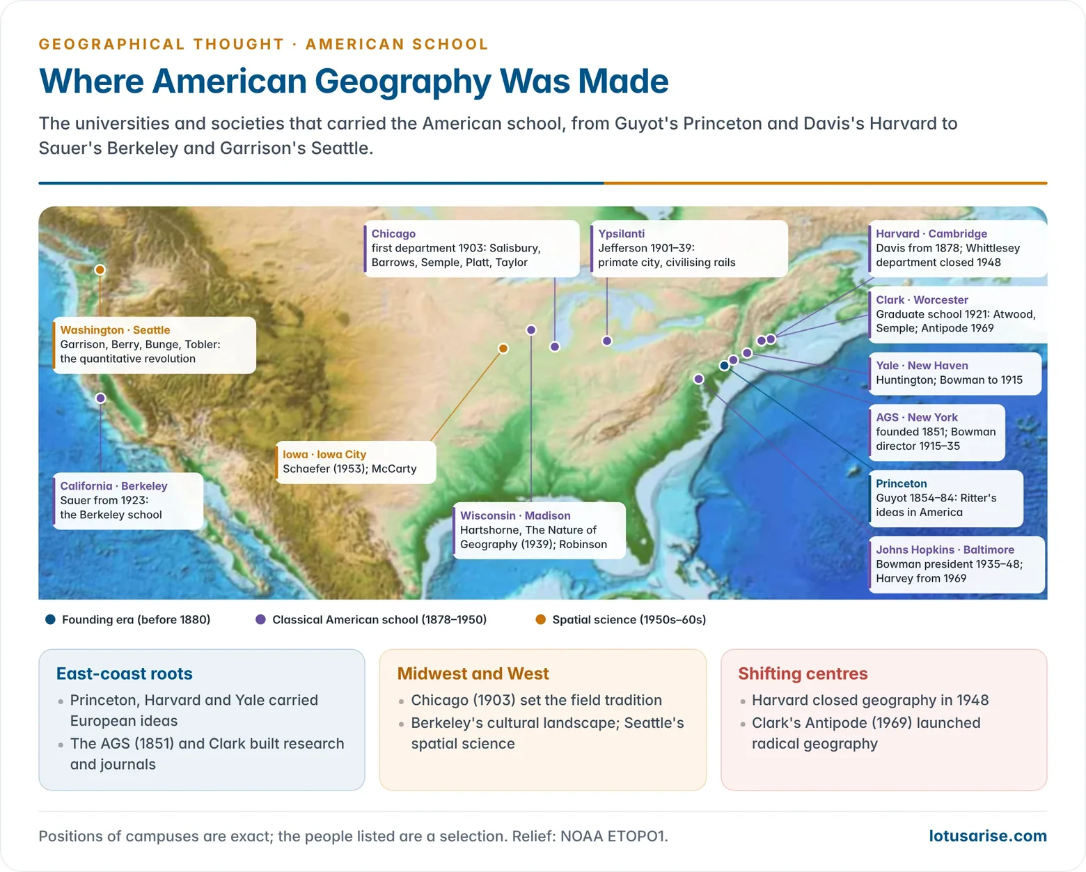
- Davis was appointed to teach physical geography at Harvard in 1878, the start of professional geography in America.
- Learned and professional bodies followed:
- The American Geographical Society (New York, 1851) and the National Geographic Society (1888) served wider audiences.
- Davis drafted the geography report of the Committee of Ten (1892), which turned school geography from memory work into a physical science of environment and response.
- He founded the Association of American Geographers (AAG) in 1904 to give the profession a forum, and served as its first president.
- The first separate department of geography opened at the University of Chicago in 1903 under the geologist Rollin D. Salisbury. Clark University (Worcester) began its Graduate School of Geography in 1921.
- Rapid growth in the early 20th century had three drivers: the western surveys, the expansion of overseas trade (which created demand for commercial geography) and the need to conserve resources such as forests, soils and oil.
- Setback: Harvard, where it all began, closed its geography department in 1948. Its president, James Bryant Conant, declared that geography was “not a university subject”. The episode shows how fragile the discipline’s identity remained.
Leading American Geographers
William Morris Davis (1850–1934)
- William Morris Davis trained in geology, worked at the Córdoba meteorological observatory in Argentina (1870–73), and spent his career at Harvard. He is regarded as the founder of professional geography in America.
- The geographical cycle: first outlined in 1884–89 and set out in “The Geographical Cycle” (Geographical Journal, 1899).
- Landforms are a function of structure, process and stage. After uplift, rivers carve a landscape through youth, maturity and old age to a peneplain, with residual monadnocks. Renewed uplift brings rejuvenation.
- Youth has steep V-shaped valleys and active downcutting. Maturity has the greatest relief, graded rivers and widening valleys. In old age, broad valleys, meanders and low divides give way to the peneplain.
- The model was deductive and time-dependent. It took Charles Lyell’s uniformitarianism, the base level of Powell, the grade of Gilbert, and a simplified Darwinian idea of change through time.
- It assumed rapid uplift followed by long stillstand and an unchanging climate. Davis treated it as an ideal sequence, a framework for the “explanatory description” of real landforms, which would always show local departures.
- The Davis cycle of erosion set a theory-led, evolutionary pattern for American geography, and Davis also applied it to glacial, coral-reef and limestone landscapes.
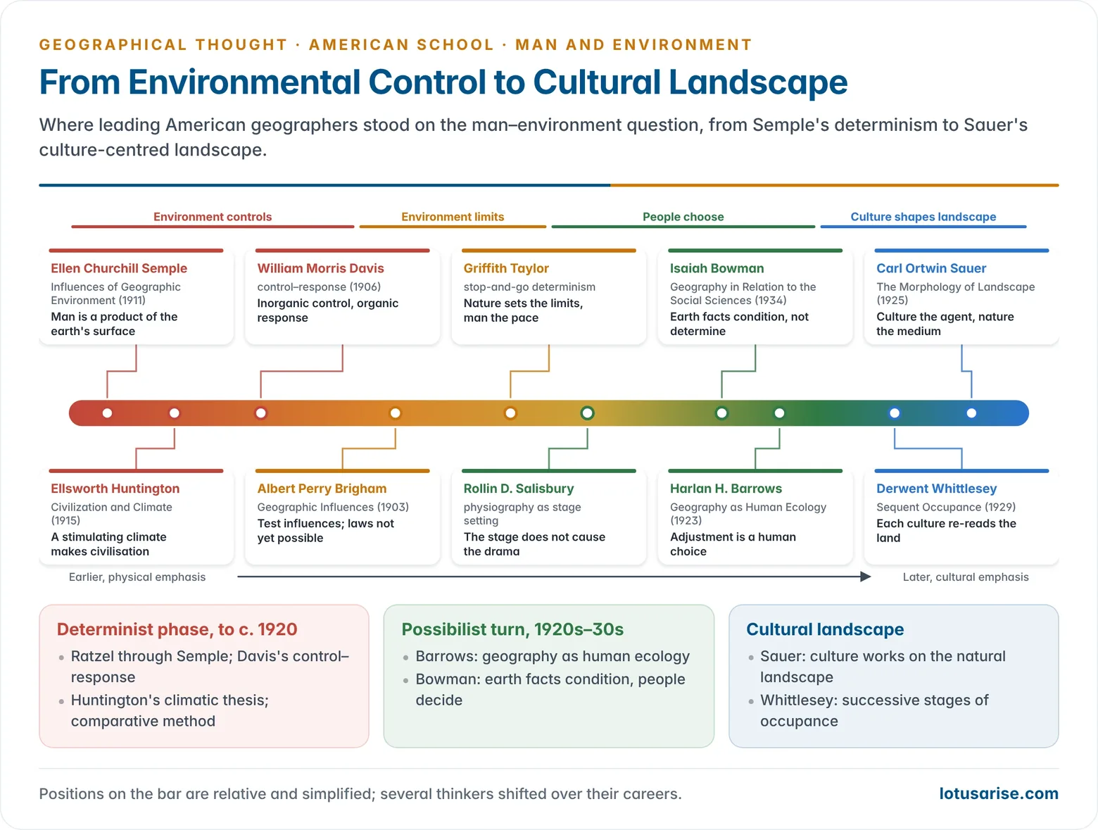
- Ontography: Davis named the organic half of geography ontography, as against physiography. A statement was geographical if it related an inorganic control to an organic response. In “An Inductive Study of the Content of Geography” (1906) he called this “the most definite, if not the only, unifying principle” of the subject.
- This control–response formula made American geography deterministic for a generation, especially in schools.
- In later life he became more ecological, stressing site, migration and association.
- Criticism:
- Alfred Hettner, Siegfried Passarge and Walther Penck in Germany called the cycle arbitrary and too rigid. It neglected climate, weathering and the interplay of uplift with erosion.
- Penck argued that uplift and erosion act together, so slope form reflects the rate of uplift against the rate of degradation, not a fixed stage. Hettner held that the scheme fitted only humid temperate lands.
- In America, John T. Hack (1960) revived Gilbert’s dynamic equilibrium, and Richard Chorley (1962) showed that the cycle was a closed system model.
- Alfred Hettner, Siegfried Passarge and Walther Penck in Germany called the cycle arbitrary and too rigid. It neglected climate, weathering and the interplay of uplift with erosion.
- Students: Mark Jefferson, Isaiah Bowman, Ellsworth Huntington and Albert Perry Brigham. Through them his influence reached every early department.
Mark Jefferson (1863–1949)
- Mark Jefferson, a student of Davis, headed geography at the Michigan State Normal College, Ypsilanti, from 1901 to 1939 and trained many teachers.
- He insisted that geography put “man on the earth” first, not “the earth and man”. He opposed the physical bias of the Committee of Ten and favoured regional knowledge of the world.
- Geography concerns people: where they are, what they are like and why they are there.
- He was a pioneer of urban geography:
- “The Anthropogeography of Some Great Cities” (1909).
- “The Civilizing Rails” (1928), on railway access and settlement.
- “The Law of the Primate City” (1939): a country’s leading city is disproportionately large and expressive of national life.
- He served as chief cartographer to the American delegation at the Paris Peace Conference (1919) and was AAG President in 1916.
- He published more papers in the Bulletin of the American Geographical Society and The Geographical Review between 1909 and 1941 than any other scholar of the time. Many were early studies of population distribution.
Ellen Churchill Semple (1863–1932)
- Ellen Churchill Semple, a Vassar history graduate, attended Ratzel’s lectures at Leipzig in 1891–92 and 1895. As a woman she could not matriculate.
- She became the leading American exponent of environmental determinism. She taught at Chicago from 1906 and later at Clark, and in 1921 she became the AAG’s first woman president.
- Her early papers on the Appalachian barrier in colonial history (1897) and the isolated Anglo-Saxons of the Kentucky mountains (1901) already linked isolation and terrain to culture.
- American History and Its Geographic Conditions (1903) explained the course of American history by its physical setting, from the Atlantic seaboard to the westward frontier.
- Influences of Geographic Environment (1911) presented the first volume of Ratzel’s Anthropogeographie to English readers. It opens: “Man is a product of the earth’s surface.”
- Her method was comparative: compare peoples of different stocks in similar environments. If they show similar development, the cause is environment, not race.
- She claimed, for example, that a wall of mountains and an unbroken, marshy coast had isolated India and fostered conservatism, while accessible Greece became an intellectual clearing house.
- Criticism:
- She chose examples that fitted and ignored those that did not. People on pass routes became robbers in her account, with no search for those who did not.
- She drew only on Ratzel’s first volume and ignored the second, which stressed human choice.
- Her generalisations were metaphysical assertions, not testable hypotheses, and they carried racial overtones.
- She herself wrote of “geographic factors” and avoided “determinants”. Her ideas of islands of ethnic expansion and retreat anticipated diffusion studies. Her later work on the ancient Mediterranean, Ancient Mediterranean Agriculture (1928) and The Geography of the Mediterranean Region (1931), spoke of influence more than control.
Albert Perry Brigham (1855–1932)
- Albert Perry Brigham, a former minister who studied with Shaler and Davis, taught at Colgate University. He was AAG President in 1914.
- Geographic Influences in American History (1903) shared Semple’s theme, but his approach was pragmatic.
- He sought empirical generalisations to test geographic influence. He held that universal laws of determinism were not yet possible.
- He rejected vague claims of climatic influence on race and urged caution.
Ellsworth Huntington (1876–1947)
- Ellsworth Huntington, a student of Davis, taught at Yale and travelled in Central Asia with the Pumpelly expedition (1903). He wrote or co-wrote some 28 books.
- The Pulse of Asia (1907): he argued that periodic desiccation of the Central Asian pastures drove nomads outward. This explained the Mongol invasions of China, India and Eastern Europe.
- Civilization and Climate (1915): he argued that high civilisation needs a stimulating climate, with moderate temperatures and frequent cyclonic changes of weather, as in north-west Europe and the north-eastern United States. In his view, the monotonous heat of the tropics held people back.
- Principles of Human Geography (1920, with Sumner Cushing) and Mainsprings of Civilization (1945) extended the argument to health, heredity and diet.
- His pulsatory hypothesis held that climate swings in cycles of cool-wet and hot-dry periods, and that these pulses moved peoples and civilisations. He tested it in Palestine and Its Transformation (1911) and in tree-ring studies of the giant sequoias.
- He was President of the Ecological Society of America (1917) and of the AAG (1923).
- Criticism:
- He gave too much weight to climate and too little to the autonomous development of societies.
- His maps of “civilisation” ranked peoples by European standards. He also led the American Eugenics Society (1934–38).
- His influence on American geography was limited, because the discipline was already turning away from determinism. His ideas have resurfaced only in qualified form in debates on climate and conflict.
Rollin D. Salisbury (1858–1922)
- Rollin D. Salisbury, a geologist, built and chaired the Chicago department from 1903 to 1919. He trained Barrows and Sauer, among others.
- He saw physiography as the study of the stage setting on which the human drama unfolds. He held that the relation of stage to action was not a causal one, which rejected simple determinism.
- His Physiography (1907) was a classic text on landform evolution. He was co-author of Elements of Geography (1912).
- He made field study central to Chicago training. Every graduate student had to identify problems from direct observation, a habit carried from the western surveys.
Isaiah Bowman (1878–1950)
- Isaiah Bowman, a student of Jefferson and Davis, taught at Yale and led expeditions to the Andes (1907–13). He described them in The Andes of Southern Peru (1916) and Desert Trails of Atacama (1924), with innovative regional diagrams.
- He was director of the American Geographical Society (1915–35) and president of Johns Hopkins University (1935–48).
- At the Paris Peace Conference (1919) he was chief territorial specialist of the American delegation. The New World: Problems in Political Geography (1921) applied regional analysis to the post-war map of Europe.
- He pioneered boundary studies, among them the Guatemala–Honduras dispute, surveyed in 1919–20 and settled only in 1933.
- He also pioneered pioneer belt studies of the margins of settlement: The Pioneer Fringe (1931) covered the American West, Canada, Australia, southern Africa, Siberia, Mongolia and South America. Limits of Land Settlement (1937), which he edited, asked how far such frontiers could absorb migrants.
- He began as a determinist but turned to possibilism. “Earth facts do not determine the form and nature of human society… They condition it.”
- In Geography in Relation to the Social Sciences (1934) he gave the example of maize and the potato: the soils of Europe had not changed, but new knowledge changed their value.
- He advised Franklin D. Roosevelt and took part in founding the United Nations. Neil Smith’s American Empire (2003) presents him as “Roosevelt’s geographer”, an architect of American global power. It also criticises his antisemitic hiring at Johns Hopkins.
Harlan H. Barrows (1877–1960)
- Harlan H. Barrows chaired the Chicago department (1919–42). In his AAG presidential address “Geography as Human Ecology” (1922, published 1923) he defined geography as the study of man’s adjustment to the natural environment.
- Adjustment is a matter of human choice, not environmental cause. This was a pragmatic possibilism close to the French school.
- He proposed that geomorphology, climatology and biogeography be left to other sciences, and that geography concentrate on human ecology, especially its economic side.
- He insisted on fieldwork as the geographer’s laboratory.
- He applied this view in New Deal water resource planning, on the Mississippi Valley Committee (1933–34) and the Water Resources Committee (1935–41). He also built the model course in the historical geography of the United States.
- Barrows’s student Gilbert F. White carried human ecology into natural hazards research. In Human Adjustment to Floods (1945) White showed that engineering works alone raise flood losses, and argued for a range of adjustments: land-use control, insurance and warning.
- With Robert Kates and Ian Burton, White built the hazards school, whose ideas now shape flood-plain zoning and disaster-risk reduction, including India’s flood management debates.
Wallace Walter Atwood (1872–1949)
- Wallace Walter Atwood, a physiographer, taught at Chicago and Harvard. He was president of Clark University (1920–46), where he built a leading Graduate School of Geography.
- He founded the journal Economic Geography (1925), which reached its centenary in 2025. His The Physiographic Provinces of North America (1940) remains a standard division of the continent.
Thomas Griffith Taylor (1880–1963)
- Thomas Griffith Taylor, born in England and raised in Australia, was senior geologist on Robert Falcon Scott’s Terra Nova expedition to Antarctica (1910–13). The Taylor Valley and Taylor Glacier are named after him.
- He founded geography at Sydney (1920), taught at Chicago (1929–35), and founded Canada’s first geography department at Toronto (1935). He was AAG President in 1941.
- His studies of Australia’s climate argued that the arid interior could never carry a large population. This was unpopular in its day, but later settlement largely bore it out.
- His neo-determinism or “stop-and-go determinism” held that nature sets the plan and the limits, while humans control the pace, like a traffic controller at a crossing.
- Other works include Environment, Race and Migration (1937), Urban Geography (1949) and the edited Geography in the Twentieth Century (1951).
Derwent Stainthorpe Whittlesey (1890–1956)
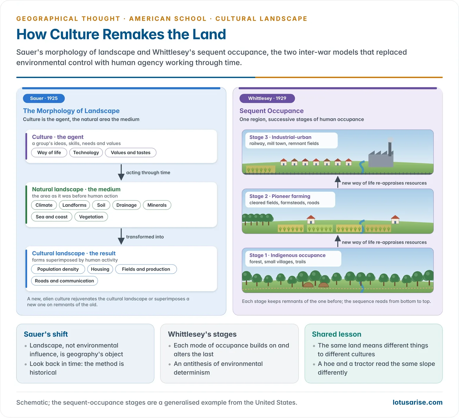
- Derwent Stainthorpe Whittlesey, of Chicago and then Harvard, introduced sequent occupance in the Annals (1929).
- A region’s landscape is a succession of stages of human occupance, each linked to the one before. Each new way of life (genre de vie) re-appraises the resource base.
- In the United States, the sudden shift from Indigenous to European occupance showed how fast regional character can change.
- Sequent occupance was an antithesis of environmental determinism. Preston James called it a kind of cultural determinism. Robert S. Platt at Chicago and many inter-war field studies used it.
- He also wrote on the world’s major agricultural regions (1936), which classified farming by crops, livestock, intensity and technology. His political geography appeared in The Earth and the State (1939).
- Late in life he proposed the term compage (1954) for a region defined by the total association of features linked to human occupance.
Carl Ortwin Sauer (1889–1975)
- Carl Ortwin Sauer, a Chicago graduate who taught at Michigan, founded the Berkeley department (1923–57) and its Berkeley school of cultural and historical geography.
- “The Morphology of Landscape” (1925), drawing on the German Landschaft idea of Otto Schlüter and Siegfried Passarge, replaced environmental influence with landscape as geography’s object.
- The landscape is an association of forms, physical and cultural. Geography studies how the natural landscape becomes a cultural landscape.
- “Culture is the agent, the natural area is the medium, the cultural landscape the result.” The arrival of a new culture superimposes a new landscape on remnants of the old.
- Within the wide limits of the environment lie many choices. These come from culture, not nature.
- The method was historical: every regional study must look back to the region’s earlier geography. This set it apart from Hartshorne’s present-centred chorology.
- In “Foreword to Historical Geography” (1941) he asked human geographers to make cultural processes the base of their thinking and observation.
- He rejected going into the field with a single dogma such as environmental control. Influences had to be tested, not assumed.
- Major themes:
- The origins and dispersal of agriculture (Agricultural Origins and Dispersals, 1952), which proposed South-East Asia as an early hearth of vegetative planting.
- The human transformation of Latin American landscapes.
- The symposium Man’s Role in Changing the Face of the Earth (1956), which renewed Marsh’s theme.
- Criticism: later cultural geographers, notably James Duncan in “The Superorganic in American Cultural Geography” (1980), attacked his “superorganic” notion of culture, which treated culture as a force above individuals, and his neglect of power and the present. These critiques led to the new cultural geography.
| Geographer | Stance | Key idea | Key work |
|---|---|---|---|
| Semple | Environmental determinism | “Man is a product of the earth’s surface” | Influences of Geographic Environment (1911) |
| Huntington | Climatic determinism | Stimulating climate makes civilisation | Civilization and Climate (1915) |
| Davis | Control–response | Inorganic control, organic response | The Geographical Cycle (1899) |
| Brigham, Salisbury | Cautious / pragmatic | Test influences; stage is not cause | Geographic Influences (1903) |
| Bowman, Barrows | Possibilism, human ecology | Environment conditions, people choose | Geography as Human Ecology (1923) |
| Whittlesey, Sauer | Cultural / landscape | Culture shapes successive landscapes | Morphology of Landscape (1925) |
Richard Hartshorne and the Regional Paradigm
- Richard Hartshorne (1899–1992), of Wisconsin, published The Nature of Geography (1939). It made the Hettnerian idea of geography as a chorological science of areal differentiation the mainstream view of American geography until the late 1950s.
- Geography gives “accurate, orderly, and rational description and interpretation of the variable character of the earth surface”. Its highest expression is regional synthesis, which is mainly idiographic.
- He distinguished formal (uniform) regions from nodal (functional) regions.
- He doubted that geography could make scientific laws. In his view it studies complex, unique places with few comparable cases, cannot experiment, and deals with human motives that defy determinism.
- In Perspective on the Nature of Geography (1959) he redefined geography as the study of “the variable character from place to place of the earth as the world of man”. He placed topical and regional studies on a single continuum, neither superior to the other.
- Fred K. Schaefer’s “Exceptionalism in Geography” (1953) attacked this position and called for a law-seeking spatial science. The Hartshorne–Schaefer debate opened the way to the quantitative revolution.
Disciplinary Trends in American Geography
- Between the wars the profession turned from the physical towards the human side. Social Darwinism and simple cause and effect lost ground. Four new approaches emerged: human ecology, chorology, historical geography and the functional organisation of space, such as a city and its trade area.
- Geography also became applied. Geographers worked on land classification, resource inventories and conservation in the 1930s. In the Second World War they served in intelligence, mapping and planning.
Inter-War Approaches
- Human ecology (Barrows) and chorology (Jefferson, Sauer and later Hartshorne) competed to define the field. Chorology won, but in two forms:
- The genetic search for change through time produced historical geography.
- The functional search for association among things in one place produced the idea of the functional organisation of space.
- Robert S. Platt’s detailed field studies of farms, towns and trade areas at Chicago, and his hierarchy of central places, gave this idea concrete form. Charles C. Colby’s “Centrifugal and Centripetal Forces in Urban Geography” (1933) explained how cities grow outward and hold together.
- Hartshorne’s “Location as a Factor in Geography” (1927) showed that location relative to raw materials, markets, power and labour mattered more for industry than relief or climate. Critics accused chorologists of “leaving the ge out of geography”.
- New Deal regional river planning under the Tennessee Valley Authority (1933), in which geographers took part, later served as the model for India’s Damodar Valley Corporation (1948).
Geomorphology
- The Davisian cycle dominated until mid-century. Douglas Johnson extended it to shorelines, and Curtis Marbut applied its youth–maturity idea to soils.
- From the 1940s a quantitative, process-based geomorphology replaced it. It drew on Robert Horton’s stream laws (1945), Arthur Strahler’s dynamic approach, Luna Leopold’s fluvial work and Hack’s dynamic equilibrium.
Regional Geography
- Regions were delimited in several ways:
- Physiographic regions came from Powell (1890s), Davis, and Nevin Fenneman’s physiographic divisions of the United States (1916, completed in 1928).
- Natural regions were drawn by W. L. G. Joerg (1914).
- Natural-economic regions were drawn by Charles Redway Dryer (1915).
- Howard Odum and Harry Moore’s American Regionalism (1938) carried the idea into sociology and planning.
- The regional paradigm reached its peak with Hartshorne in the 1940s. By the 1950s, disillusionment with its empiricism turned young geographers to systematic specialisms.
Historical Geography
- Ralph Hall Brown reconstructed the eastern seaboard of about 1810 through the eyes of contemporaries in Mirror for Americans (1943). This anticipated perception studies. He followed it with Historical Geography of the United States (1948).
- Sauer’s Berkeley students and Whittlesey’s sequent occupance showed that the same land means different things to people with different cultures and technologies. Slope means one thing for a farmer with a hoe and another for one with a tractor.
Systematic Geography and the Quantitative Revolution
- After Schaefer, the quantitative revolution developed at three centres:
- Iowa: Harold McCarty measured correspondence between spatial patterns.
- Wisconsin: Arthur H. Robinson worked on statistical map comparison. He later designed the Robinson projection (1963).
- Washington, Seattle: William Garrison’s group borrowed economic theory and linear programming for locational analysis. It included Brian Berry, Michael Dacey, Richard Morrill, Waldo Tobler and William Bunge.
- William Bunge’s Theoretical Geography (1962) attacked Hartshorne’s uniqueness argument. Edward Ullman explained trade by complementarity, intervening opportunity and transferability (1956). Waldo Tobler’s “first law of geography” (1970) held that near things are more related than distant things.
- Social physics: the Princeton astronomer John Quincy Stewart and William Warntz treated population, distance and time as social dimensions, which led to gravity and potential models and “macrogeography”.
- Walter Isard’s Location and Space-Economy (1956) founded regional science, an interdisciplinary field of location theory, input–output and regional planning models.
- Edward Ackerman’s “Geography as a Fundamental Research Discipline” (1958) called for systematic, team-based research. A visit to Seattle by the Swedish geographer Torsten Hägerstrand brought diffusion and simulation into the American spatial tradition.
- David Harvey’s Explanation in Geography (1969) gave the new geography its philosophy of hypothesis testing.
Urban and Economic Geography
- Chauncy D. Harris and Edward L. Ullman’s “The Nature of Cities” (1945) proposed the multiple nuclei model. Harris also produced a functional classification of American cities (1943).
- Berry developed central place and urban systems studies. Jefferson’s primate city and Platt’s hierarchy of central places preceded them.
Other Systematic Branches
- Climatology: Charles Warren Thornthwaite’s classifications (1931, 1948) introduced potential evapotranspiration as a measure of moisture need. Glenn Trewartha adapted Köppen’s scheme for teaching.
- Population geography: Trewartha’s AAG presidential address, “A Case for Population Geography” (1953), established it as a separate branch.
- Resource geography: Erich Zimmermann’s World Resources and Industries (1933) held that “resources are not, they become”: a thing becomes a resource only through human knowledge and need.
- Transport geography: Edward Taaffe, Richard Morrill and Peter Gould modelled transport expansion in underdeveloped countries (1963) from the cases of Ghana and Nigeria.
- Cartography and remote sensing: Robinson’s Elements of Cartography (1953) standardised map design teaching. The launch of Landsat (1972) opened the age of satellite remote sensing.
| Branch | Leading American figures | Main contribution |
|---|---|---|
| Geomorphology | Davis, Gilbert, Horton, Strahler, Hack | Cycle, then process and equilibrium |
| Regional | Joerg, Fenneman, Hartshorne | Regions; areal differentiation |
| Historical / cultural | Sauer, Whittlesey, Brown | Cultural landscape, sequent occupance |
| Human ecology | Barrows | Adjustment as human choice |
| Urban / economic | Jefferson, Harris, Ullman, Berry, Isard | Primate city, multiple nuclei, interaction, regional science |
| Spatial science | Schaefer, Garrison, Bunge, Tobler | Laws, models, quantification |
Current Trends in American Geography
- Three epistemologies now coexist:
- Positivist spatial analysis seeks laws of spatial organisation from patterns.
- Humanistic approaches see people as free agents in worlds of their own meaning.
- Structuralist or realist approaches, chiefly Marxist, seek explanation in the processes beneath the patterns.
- Behavioural geography, with Julian Wolpert’s satisficer (1964), Robert Kates’s flood-plain studies, and Peter Gould and Rodney White’s Mental Maps (1974), studied perception and decision.
- Radical geography:
- The journal Antipode was founded at Clark University in 1969, and William Bunge led the Detroit Geographical Expedition into the city’s poorest neighbourhoods.
- Harvey’s Social Justice and the City (1973) brought Marxism into the centre of the discipline.
- Humanistic geography: Yi-Fu Tuan’s Topophilia (1974) and Space and Place (1977) made place and experience central.
- Feminist geography: Janice Monk and Susan Hanson’s “On Not Excluding Half of the Human in Human Geography” (1982) challenged the gender blindness of the discipline.
- Political ecology: Michael Watts’s Silent Violence (1983), on famine in northern Nigeria, linked hazards and hunger to political economy rather than to nature alone.
- Postmodern geographies: the Los Angeles school, with Edward Soja’s Postmodern Geographies (1989) and Michael Dear, read the city as fragmented and decentred, against the Chicago school’s concentric model.
- GIScience:
- The National Center for Geographic Information and Analysis (1988) and Michael Goodchild’s call for a geographic information science (1992) made the United States the leader in GIS.
- Remote sensing and spatial data science followed, aided by commercial GIS.
- Spatial turn: history, sociology and the humanities have borrowed geography’s concepts of place, scale and network. At the same time, big data, satellite imagery and geospatial artificial intelligence have made spatial data science a growth field.
- Critical cartography and GIS: scholars have questioned whose knowledge maps and GIS represent. Participatory and Indigenous mapping now gives communities a voice in land claims and planning.
- The profession: the AAG became the American Association of Geographers in 2016, reflecting its international membership. Current research spans climate adaptation, hazards, migration and urban inequality.
- India in American geography:
- Brian Berry’s Essays on Commodity Flows and the Spatial Structure of the Indian Economy (1966) applied spatial analysis to India’s regions.
- Joseph E. Schwartzberg’s A Historical Atlas of South Asia (1978) remains a standard work on the subcontinent.
Evaluation
- Strengths:
- The school gave the discipline its first evolutionary model (Davis) and its classic determinism–possibilism debate.
- It produced the cultural landscape idea (Sauer) and the definitive statement of the regional paradigm (Hartshorne).
- It led the quantitative, behavioural, radical and GIS revolutions.
- Limitations:
- Its early phase was heavily deterministic, with racial overtones (Semple, Huntington).
- It moved between physical and human emphases until physical geography was neglected. The Harvard closure exposed its weak institutional identity.
- Like other national schools, it absorbed the concerns of American power, from Bowman’s diplomacy to Cold War area studies.
- Set beside the German, French, British and Russian schools, the American school stands out for its openness to new paradigms. Most of the 20th century’s paradigm shifts began in its universities.
Previous Year Questions
- No direct PYQ has been asked on this sub-topic yet.