

- The Russian school is the body of geographical thought built up in Tsarist Russia, the Soviet Union (1917–1991) and post-Soviet Russia.
- It grew from the practical needs of the largest continuous state on earth: exploring, mapping, governing and later planning a territory that runs from the Baltic to the Pacific.
- Three traits set it apart from the other national schools:
- Regions were treated as real, objectively definable units, and geography was expected to serve practical, often state, purposes.
- Geography stayed a meeting ground of many specialities (soils, climate, hydrology, ethnography, economics) instead of splitting into separate sciences.
- Natural landscapes were studied as systems of interrelated parts, an idea that runs from Dokuchaev’s soil zones to Sochava’s geosystems.
- Because most of it was written in Russian, much of this work reached the rest of the world late and second-hand, often only through translation.
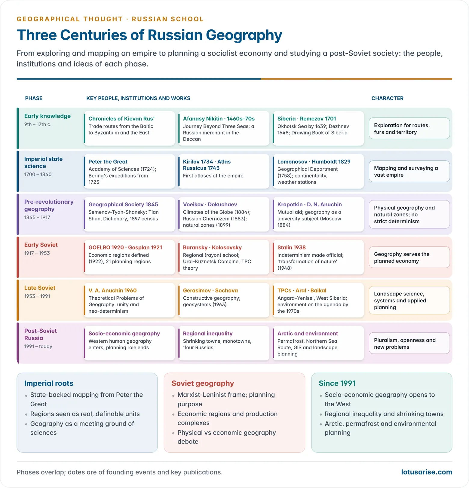
Phases of Russian Geographical Thought

| Phase | Period | Character | Key figures and institutions |
|---|---|---|---|
| Early knowledge | 9th–17th c. | Routes, travel accounts, Siberian expansion | Chronicles of Kievan Rus’, Afanasy Nikitin, Remezov |
| Imperial (pre-revolutionary) | 1700–1917 | State mapping, exploration, rise of physical geography | Academy of Sciences (1724), Lomonosov, Imperial Geographical Society (1845), Semenov-Tyan-Shansky, Voeikov, Dokuchaev, D. N. Anuchin, Kropotkin |
| Soviet | 1917–1991 | Marxist-Leninist, planning-oriented, physical and economic geography | Baransky, Kolosovsky, Berg, Grigoriev, Gerasimov, V. A. Anuchin, Sochava |
| Post-Soviet | 1991 onwards | Pluralism, opening to Western ideas, regional inequality, environment, GIS | Institute of Geography RAS, Moscow State University, Russian Geographical Society |
The Pre-Revolutionary Foundations
Early Knowledge: Routes, Travellers and Siberia (to 1700)
- The chronicles of Kievan Rus’ (the Primary Chronicle, early 12th century) already record trade routes linking the Baltic with Byzantium, the Caspian and the lands of the East.
- Early interest lay in the extent of the land, the routes of trade and communication, and the rivers that tied the country together.
- Afanasy Nikitin, a merchant of Tver, travelled to India in the 1460s–70s. His Journey Beyond Three Seas is among the earliest European eyewitness accounts of the Bahmani kingdom of the Deccan.
- Expansion across Siberia from the 1580s turned exploration into a state enterprise:
- Cossack parties reached the Sea of Okhotsk by 1639, and Semyon Dezhnev sailed round the north-eastern tip of Asia in 1648.
- Expeditions charted rivers, coasts and portages and looked for furs and precious metals.
- Semyon Remezov of Tobolsk compiled the Drawing Book of Siberia (1701), the first atlas of Siberia.
State Mapping and the Academy (18th Century)
- Peter the Great (ruled 1682–1725) saw accurate geographical knowledge as essential to the eastward growth of the empire.
- He founded the Academy of Sciences (1724) and ordered Vitus Bering’s first Kamchatka expedition (1725–30). The Great Northern Expedition (1733–43) followed.
- Ivan Kirilov issued the first general atlas of the empire in 1734. The Academy’s Atlas Russicus followed in 1745.
- Mikhail Vasilyevich Lomonosov (1711–1765) took charge of the Academy’s Geographical Department in 1758.
- He asked exploring parties to collect systematic information on land, population and economy, an early model of the regional survey.
- German influence was strong. Anton Friedrich Büsching’s description of Russia, translated in 1766, divided European Russia into latitudinal zones (north, middle, south).
- His proposal to divide the empire into natural regions for administration was quickly taken up. Regional descriptions, mostly of political units, multiplied by 1800.
- Alexander von Humboldt travelled through Russia in 1829 at the invitation of Tsar Nicholas I: the Urals, the Altai up to the Chinese frontier, and the Caspian shore.
- His observation that temperatures differ at the same latitude with distance from the sea fed the idea of continentality. He also urged a network of magnetic and weather stations across the empire.
Institutions of the 19th Century
- The Imperial Russian Geographical Society was founded in 1845 (Konstantin Arsenyev among its founders).
- It promoted geology, meteorology, hydrology, anthropology and archaeology together, known collectively as the “geographical sciences”.
- It sponsored the great Asian expeditions, such as those of Nikolai Przhevalsky in Central Asia.
- Arsenyev’s Short Universal Geography (1818) had a strong economic emphasis and concern for the condition of the peasantry.
- University geography took shape in the 1880s. Moscow University created a Department of Geography and Ethnography in 1884 under Dmitry Nikolayevich Anuchin.
- No break after 1859: in Germany, the deaths of Humboldt and Ritter left a gap; in Russia, geographical work continued without interruption.
Leading Geographers before 1917
- Most leading Russian geographers trained in, or kept close contact with, German geography (Ritter, Richthofen, Ratzel). Yet they preferred causal, mechanical explanation to Ritter’s teleology.
- They did not accept extreme environmental determinism. They saw people as active agents who change the land, a view that set them apart from Ratzel’s followers.
Mikhail V. Lomonosov (1711–1765)
- Encyclopaedic scientist who laid early foundations of geology and geomorphology in Russia. His On the Strata of the Earth (1763) is a classic.
- He held that landforms result from the joint action of internal (endogenic) and external (exogenic) forces, and that the same processes act uniformly over the earth’s surface.
- He studied Arctic ice and currents and argued for a northern sea route to the Pacific.
Pyotr Petrovich Semenov-Tyan-Shansky (1827–1914)
- Attended Ritter’s lectures in Berlin and translated Ritter, but rejected his teleology.
- Explored the Tian Shan in 1856–57. The epithet Tyan-Shansky was added to his name in 1906 in honour of that work.
- Led the Geographical Society from 1873 until his death. Edited the multi-volume Geographical-Statistical Dictionary of the Russian Empire (from 1863) and organised the first census of 1897.
- Brought a welfare and social-relevance concern into geography: rural poverty, hunger and inequality. He wanted geography to be practical and remedial.
- His son Veniamin Semenov-Tyan-Shansky wrote major regional works on European Russia.
Alexander Ivanovich Voeikov (1842–1916)
- Russia’s leading climatologist; trained at Berlin, Göttingen and Heidelberg. His major work is Climates of the Globe, Particularly Russia (1884).
- Key ideas:
- Studied the earth’s heat and water balance and the climatic role of snow cover, pioneering snow science.
- Applied climatology to agriculture, comparing Russian conditions with similar climates abroad. Tea in Georgia, cotton in Turkestan and wheat in Ukraine were advocated on that basis.
- Saw man as an agent of environmental change: overgrazing of the steppes caused gully erosion, and forest clearance could make climates drier. He championed irrigation of semi-arid lands.
Vasily Vasilyevich Dokuchaev (1846–1903)
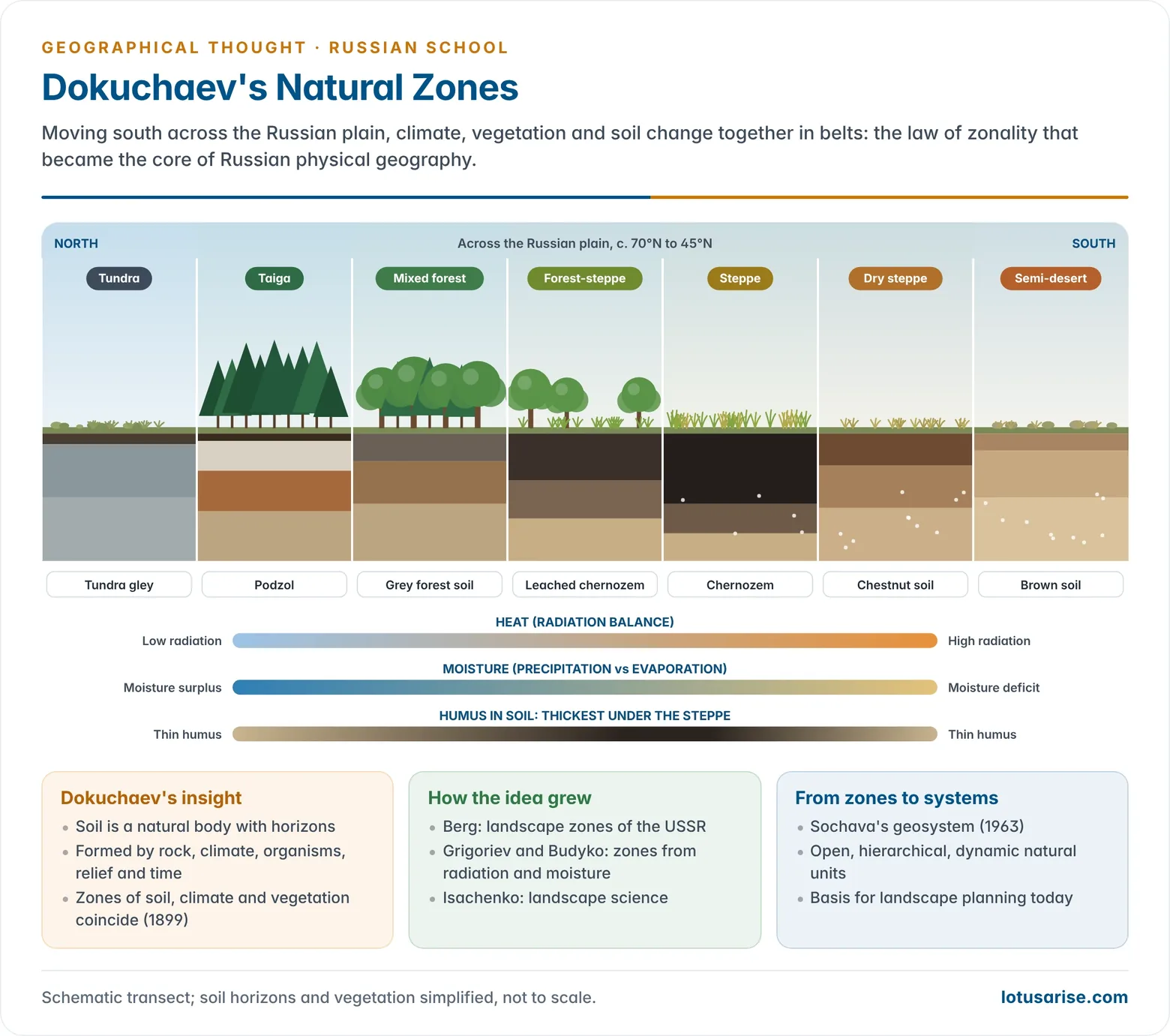
- Founder of genetic soil science and of the doctrine of natural zones; he taught at St Petersburg University.
- Russian Chernozem (1883) showed that soil is a natural body with its own horizons, not merely weathered rock.
- Soil results from the interaction of parent rock, climate, organisms, relief and time. Over long periods, climate and vegetation leave a stronger stamp on soil than the parent rock does.
- Toward a Theory of Zones of Nature (1899): soils, climate and vegetation form integrated latitudinal zones (tundra, taiga, forest-steppe, steppe, desert). This became the law of zonality.
- After the drought of 1891 he planned shelterbelts, ponds and water regulation for the steppe (Our Steppes Past and Present, 1892). It was an early exercise in applied environmental management.
- He saw man as a transformer of natural zones into agricultural landscapes, close to Otto Schlüter’s cultural landscape (Kulturlandschaft).
- His pupils carried the ideas abroad: Nikolai Sibirtsev separated zonal from azonal soils, and Konstantin Glinka’s work on the great soil groups, translated by Curtis F. Marbut (1927), shaped American soil classification.
Peter Kropotkin (1842–1921)
- Geographer and the leading thinker of anarchism. His Siberian expeditions of the 1860s produced work on the orography of East Asia and on the glaciation of Finland and northern Europe.
- Mutual aid: against the Social Darwinism of Herbert Spencer, he argued that co-operation within species, not only struggle, drives evolution and social progress (Mutual Aid, 1902).
- “What Geography Ought to Be” (1885): geography should awaken a love of nature, teach that “we are all brethren” and dispel national and racial prejudice.
- He opposed the use of geography for imperialism and militarism and favoured decentralised, self-sufficient communities in harmony with their surroundings.
- In exile in Britain (1886–1917), he worked with the Royal Geographical Society. With his friend Élisée Reclus of the French school, he inspired the anarchist strand of radical geography in the 1970s.
Dmitry Nikolayevich Anuchin (1843–1923)
- Anthropologist and geographer, trained in the German tradition at Heidelberg; head of Moscow’s geography department from 1884.
- Established geography as a university and school subject. He wrote textbooks and founded the journal Zemlevedenie (Earth Science).
- Saw man as part of nature, and doubted claims about environmental influence on culture that could not be measured.
- His students, such as Lev Berg, carried the Moscow tradition into the Soviet period.
Soviet Geography (1917–1991)
Geography in the Service of the Planned Economy
- After the October Revolution (1917), research and teaching had to follow Marxism-Leninism. Contact with Western geography was largely cut off.
- For Lenin, geography was an applied subject. Its most important product was the identification of rational economic regions on which a new economy could be built.
- Planning institutions:
- The GOELRO plan (1920) for electrification was the first state plan built on regional resource analysis.
- Gosplan, the State Planning Commission (1921), defined the economic region in 1922 as a territory integrated by its natural resources, inherited skills and capital, specialised within the national economy. It divided the country into 21 regions.
- Geographers, economists and engineers prepared resource inventories and helped choose industrial locations.
- Lenin rejected determinism in practice. He dismissed the view that the steppes north of the Black Sea could never be farmed, because it ignored technological change.
- Stalin era: dissent risked arrest. Rigid central control weakened regional study, and physical and economic geography drew apart.
- After 1953: geographers turned to resource planning, territorial production complexes, nature transformation projects and, from the 1970s, environmental problems.
Leading Soviet Geographers
Nikolai Nikolayevich Baransky (1881–1963)
- Founder of the Soviet regional (rayon) school of economic geography.
- Wrote Economic Geography of the USSR (1926), organised Moscow University’s department of economic geography (1929), and was elected corresponding member of the Academy (1939).
- He insisted that economic geography is a geographical science, rooted in regions and maps. He led the movement for the unity of geography.
- He worked on the geography of cities and urged a classification of Soviet cities (1946).
Nikolai Nikolayevich Kolosovsky (1891–1954)
- Gosplan economist-geographer who worked on the Ural–Kuznetsk Combine and Siberian resource schemes.
- He gave the theory of the territorial production complex (TPC) and of energy–production cycles its classic form in the late 1940s.
Physical Geographers and Landscape Scientists
- Lev Semyonovich Berg (1876–1950): divided the USSR into landscape zones, building on Dokuchaev. He presided over the Geographical Society (1940–50).
- His Nomogenesis (1922) proposed directed evolution by law rather than chance selection, against Darwin.
- Yuly Mikhailovich Shokalsky (1856–1940): oceanographer and cartographer. He coined the term “World Ocean” (1917) and separated oceanography from hydrography.
- Nikolai Mikhailovich Knipovich (1862–1939): pioneer of marine fisheries research in the Barents, Caspian, Azov and Black Seas.
- Andrei Aleksandrovich Grigoriev (1883–1968): directed the Academy’s Institute of Geography (1923–56). He developed the concept of the geographical (physical-geographic) envelope, the zone of interaction of lithosphere, atmosphere, hydrosphere and biosphere.
- With Mikhail Budyko, he linked natural zones to the balance of radiation and moisture, the “periodic law” of zonality.
- Innokenty Petrovich Gerasimov (1905–1985): directed the Institute of Geography (1956–85) and championed constructive geography: knowledge of landscapes should be used to transform nature for the economy.
- His examples included the heat and water budgets of the chernozem forest-steppe, salinity and water use in irrigated Central Asia (with the fate of the Aral Sea), swamp reclamation, and pollution control at Lake Baikal.
- Anatoly Grigoryevich Isachenko and Viktor Borisovich Sochava (1905–1978) developed landscape science.
- Sochava’s concept of the geosystem (1963) treats a landscape as an open, hierarchical, dynamic system of interrelated natural components. It parallels Western systems analysis.
Theorists of the Discipline
- V. A. Anuchin, in Theoretical Problems of Geography (1960), argued for a unified geography and set off the fiercest methodological debate of Soviet geography.
- Yu. G. Saushkin, author of Introduction to Economic Geography (1958), supported a unified geography and a realistic view of nature’s role.
- O. A. Konstantinov led Soviet urban geography, with quantitative typologies of cities from the 1960s.
- S. V. Kalesnik and other physical geographers defended physical geography as a separate natural science.
Territorial Production Complexes
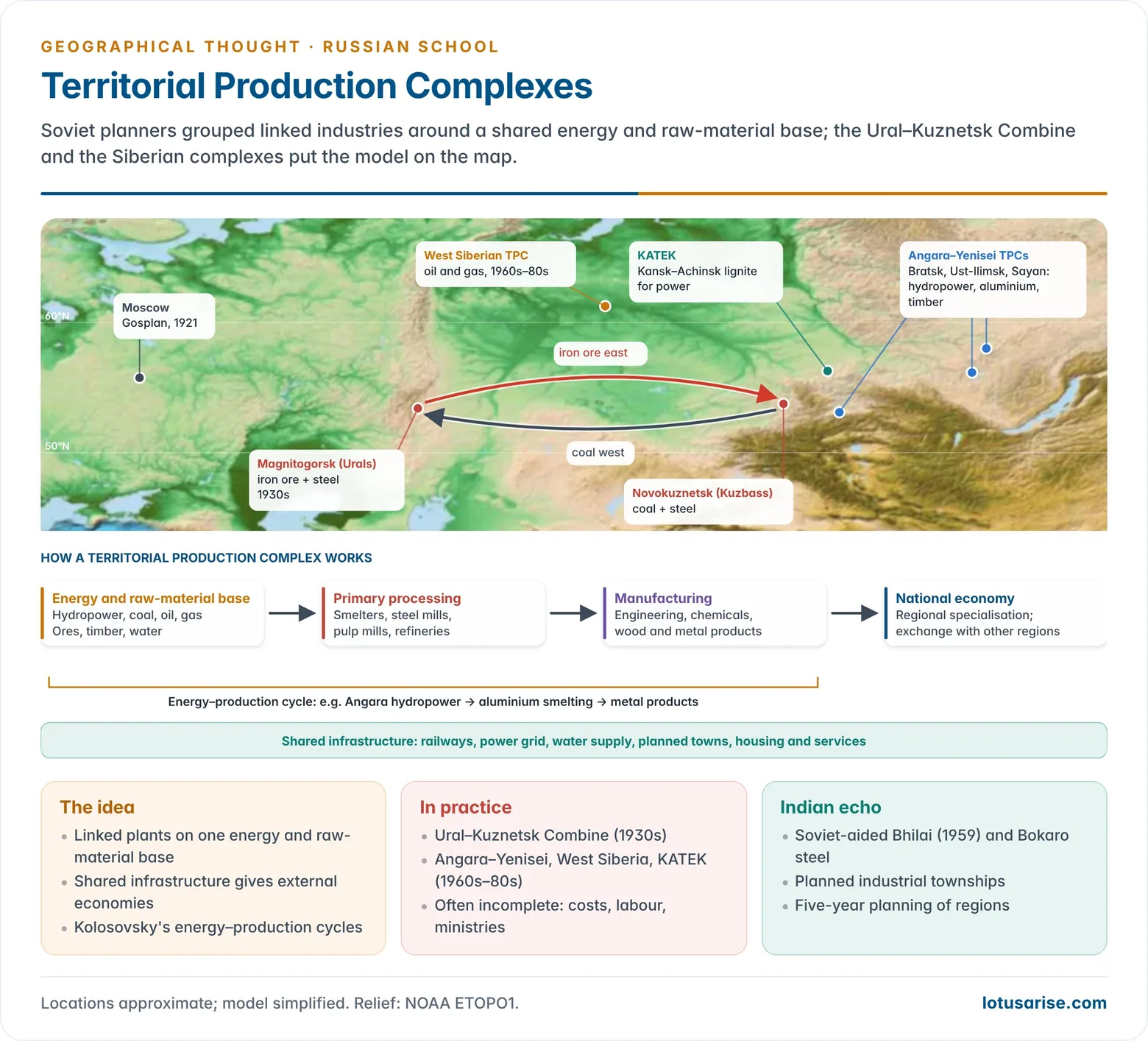
- A territorial production complex (TPC) is a planned grouping of interlinked industries in one region, built on a shared base of energy and raw materials, with common infrastructure and settlement.
- Logic: placing linked activities together saves on transport and gives external economies, so the whole yields more than the parts.
- Energy–production cycles: chains of linked activities, from raw material through processing to finished goods, that recur in different regions (for example, hydropower to aluminium, or coal and iron ore to steel to engineering).
- Examples:
- The Ural–Kuznetsk Combine (1930s) exchanged Ural iron ore and Kuznetsk coal by rail to build two steel bases 2,000 km apart.
- The Angara–Yenisei complexes of the 1960s–80s (Bratsk–Ust-Ilimsk, Sayan) used cheap hydropower for aluminium and timber processing.
- Others included the West Siberian oil-and-gas complex and KATEK (Kansk–Achinsk coal).
- Limits: costly infrastructure, labour shortages in harsh northern locations, environmental damage, and departmental (ministry) rivalry often kept complexes incomplete.
- Indian echo: Soviet-aided steel plants at Bhilai (first production 1959) and Bokaro, and the planned industrial townships around them, borrowed the logic of complex development. Soviet-style five-year planning also shaped Indian regional planning.
The Great Debates of Soviet Geography
Physical versus Economic Geography: Unity or Two Sciences?
- Soviet geography was split by a sharp dualism: the laws of nature and the laws of society were said to differ, so physical and economic geography could not form one science.
- Physical geographers (Dokuchaev’s heirs, Gerasimov, Kalesnik) saw their field as a nomothetic natural science: landscape science, models and prediction.
- Economic geographers leaned on social laws and regional description. Konstantinov (1926) even wanted economic geography to break with geography altogether and become a purely economic discipline.
- Baransky led a movement for unity from the 1920s, given official support by two decrees in 1934. His own unity leaned towards economic geography.
- V. A. Anuchin (1960) attacked both an “inhuman” physical geography and an “unnatural” economic geography. He called for a synthetic “geography without adjectives” able to forecast the effects of human interference with nature.
- Baransky and Saushkin backed him. Many physical geographers, and some economic geographers, attacked him as anti-Marxist.
- Outcome: by the 1970s a measure of synthesis returned through landscape science, geosystems and environmental problems, which needed both natural and social knowledge.
Determinism versus Indeterminism
- Russia was unusual in having both environmentalist and anti-environmentalist paradigms in strength. Germany leaned to determinism and France to possibilism.
- Environmentalist (determinist) strand, carried mainly by historians rather than geographers:
- Sergei Solovyov and Vasily Klyuchevsky traced the Russian character and history to the forests, steppes and rivers of the plain. Klyuchevsky also recognised man’s part in shaping that environment.
- Lev Mechnikov, in Civilisation and the Great Historical Rivers (1889), made rivers the key to early civilisations. He located the cause in the relation between environment and a people’s capacity for co-operation, not in the environment alone.
- Georgi Plekhanov (1856–1918), the first major Russian Marxist, fused this with Marxism: geographical environment → productive forces → economic relations → all other social relations.
- Baransky (1926) accepted nature as the natural basis of productive forces, but rejected both “geographical fatalism” and “geographical nihilism”.
- V. A. Anuchin’s “neo-determinism”:
- The geographical environment includes nature already changed by human activity, and this modified nature in turn influences society.
- Determinism’s fault was its mechanical chain of cause and effect, not the recognition of nature’s influence. Indeterminism, which cut society off from nature, was anti-scientific.
- This Soviet usage differs from Griffith Taylor’s neo-determinism, which is about nature fixing the direction of development.
- Indeterminist strand (a form of possibilism), which became the official line:
- Nikolai Chernyshevsky explained national character and progress without appeal to environment. Mikhail Pokrovsky (1931) held that labour, not nature, is the foundation of the economy.
- Stalin (1938) declared that environment can accelerate or retard development but cannot determine it, because society changes far faster than nature. Determinism became a “bourgeois” error.
- Voskanyan stressed man’s control over nature. Kalesnik, Konstantinov and others defended an anthropocentric view of nature as an object of use.
- Saushkin rejected possibilism as well. He held it treats nature merely as an object for exploitation, like an “exploiter man” and “exploited nature”. For him man can master nature only by understanding and applying its laws.
| Position | Main proponents | View of nature | Fate |
|---|---|---|---|
| Environmentalism | Solovyov, Klyuchevsky, Mechnikov, Plekhanov | Shapes history and productive forces | Condemned as “geographical fatalism” |
| Moderate Marxist | Baransky, Saushkin | Natural basis of production, acting through it | Mainstream of economic geography |
| Neo-determinism | V. A. Anuchin (1960) | Humanised nature influences society | Fierce debate; partly accepted later |
| Indeterminism | Chernyshevsky, Pokrovsky, Stalin (1938), Voskanyan | Material for labour; no determining role | Official line from 1938; feeds “conquest of nature” |
- Consequence: the doctrine that nature could be remade at will underpinned the Great Plan for the Transformation of Nature (1948), river-diversion schemes and the irrigation that shrank the Aral Sea. Environmental limits returned to Soviet geography only from the 1970s.
- The wider history of environmentalism and the classic determinism–possibilism debate show where the Soviet positions stand internationally.
Branches and Disciplinary Trends
Physical Geography
- Physical geography sought general laws behind the distribution of natural features and kept the status of a natural science.
- Specialisations grew quickly:
- Climatology: radiation budget, moisture cycle and dynamic forecasting.
- Hydrology: the water budget and the links between surface, soil and ground water.
- Glaciology: heat and mass exchange in glaciers.
- Geomorphology: the morphostructural approach, which links relief to recent crustal movements.
- Soil geography: new soil types of taiga, desert and mountains, culminating in the 1:1,000,000 soil map of the USSR.
- Biogeography: ecological approaches to plant and animal groupings.
- Landscape science (landshaftovedenie) was the integrating core: a landscape is a dynamic system with flows of matter and energy and seasonal rhythms of heat, water and biological productivity.
- Landscape classifications at several scales became the basis for natural regions and planning.
Economic and Planning Geography
- Economic geography concentrated on the location of productive forces, economic regionalisation, and the effect of production on the social and political superstructure.
- Planning geography served regional and sectoral planning. It covered:
- industrial deployment in backward regions and the TPCs;
- agricultural schemes such as the expansion of cultivation in the Virgin Lands of Kazakhstan and Siberia (1954 onwards);
- routing of roads, railways and pipelines;
- siting of services, resorts and health facilities.
- From the 1970s, economic geography became steadily more applied: regional planning, town planning and resource management.
Social and Cultural Geography
- After the Second World War, R. M. Kabo proposed a socio-cultural geography of the man–nature relationship. The economic-geography mainstream did not accept it.
- Interest revived in the last quarter of the 20th century:
- Saushkin wrote on the cultural landscape.
- V. M. Gokhman divided human (social-economic) geography into social geography (territorial aspects of social structure), economic geography (territorial organisation of production and exchange) and cultural geography (territorially differentiated cultures and their change).
Resources, Population, Hazards and Recreation
- Resource and population geography: the balance between population and resources, uneven distribution of people, and demographic policy. Brezhnev’s call at the 25th Party Congress (1976) put environment and population on the research agenda.
- Hazards: mudflows, avalanches, droughts and soil erosion; forecasting of weather and of changes in the hydrological balance.
- Recycling and resource cycles: tracing raw materials from extraction through production to their return to the environment as waste.
- Recreational geography: green and recreational zones around large cities to offset urbanisation.
| Branch | Main concern | Leading names |
|---|---|---|
| Soil and landscape science | Zonality, landscapes as systems, geosystems | Dokuchaev, Berg, Isachenko, Sochava |
| Climatology and hydrology | Heat and water balance, snow, glaciers | Voeikov, Grigoriev, Budyko |
| Constructive geography | Using landscape knowledge to transform nature | Gerasimov |
| Economic geography | Economic regions, location of productive forces | Baransky, Kolosovsky, Saushkin |
| Urban geography | City classification, quantitative typologies | Baransky, Konstantinov |
| Social and cultural geography | Cultural landscape, social structure in space | Kabo, Saushkin, Gokhman |
Contemporary Russian Geography (after 1991)
- The collapse of the USSR ended central planning and much state funding. It also ended the isolation, and with it the compulsory Marxist-Leninist frame.
- Economic geography became “socio-economic geography”, and Western human geography (political, cultural, urban and behavioural) entered teaching and research.
- Regional inequality is now a central theme. Natalia Zubarevich’s “four Russias” (2011–12) contrasts:
- post-industrial big cities;
- Soviet-era industrial towns;
- rural and small-town Russia;
- underdeveloped republics of the North Caucasus and southern Siberia.
- Urban geography studies the growth of Moscow and St Petersburg, shrinking towns and single-industry “company towns” (monogoroda).
- Environment and climate: permafrost thaw, Arctic warming, the Northern Sea Route, forest fires and pollution are leading fields. Landscape planning continues the geosystem tradition.
- Cartography and geoinformatics: thematic mapping, national atlases, GIS and remote sensing for planning and resource management.
- Recreational and tourism geography has grown into a training field in its own right, along with environmental management and landscape planning.
Evaluation of the Russian School
- Contributions:
- Integrated, systemic views of nature: Dokuchaev’s zonality, landscape science and the geosystem anticipated Western ecosystem and systems thinking.
- Applied, planning-oriented geography: economic regionalisation and the TPC are among the most ambitious uses of geography in state planning.
- Social conscience: Semenov’s concern with poverty and Kropotkin’s mutual aid anticipated welfare and radical geography.
- Limitations:
- Ideological control narrowed debate and punished dissent; the “conquest of nature” doctrine caused environmental disasters such as the Aral Sea.
- The language barrier and isolation limited exchange with the West in both directions.
- Human, cultural and behavioural themes were neglected until late.
| Feature | Russian / Soviet school | German school | French school |
|---|---|---|---|
| Core idea | Natural zones; landscape as system; economic region | Landscape (Landschaft), chorology | Genre de vie, pays |
| Man–nature view | Active man; later official indeterminism | Leaned to determinism (Ratzel) | Possibilism |
| Purpose | Practical, state planning | Academic, regional synthesis | Regional monographs |
| Organisation | Academy institutes, planning bodies | Universities | Universities |
Previous Year Questions
- No direct PYQ has been asked on this sub-topic yet.




