

- Environment and human health is the study of how the physical, biological and social surroundings of people shape their health, illness and death, and how changes in those surroundings change the pattern of disease.
- It joins medical (health) geography, ecology and epidemiology: a disease has a place, a season and a community, and each of these is an environmental fact.
- The World Health Organization (1948) defines health as a state of complete physical, mental and social well-being, not merely the absence of disease or infirmity. Environment touches every part of that definition.
- Unhealthy environments kill on a huge scale. The WHO estimated that about 12.6 million deaths in 2012 (23% of all deaths) were attributable to modifiable environmental risks: polluted air, unsafe water and sanitation, chemicals, radiation, noise, occupational hazards and degraded ecosystems.
- Two forces now drive the geography of disease: ecological change (deforestation, dams, irrigation, urbanisation) and climate change. Both act through the same ecological chain that links pathogens, vectors, hosts and habitats.
Health, Environment and Disease Ecology

Environmental determinants of health
- Health is the outcome of an interaction between the physical setting, the biological world of pathogens and vectors, and the cultural traits of the people who live there.
| Group of determinants | Examples | Typical health link |
|---|---|---|
| Climatic | Temperature, humidity, rainfall, seasons, extremes | Heat stroke, cold injury, seasonal malaria, monsoon diarrhoea |
| Geochemical and terrain | Rocks, soils, groundwater chemistry, altitude | Fluorosis, arsenicosis, iodine-deficiency goitre, hypoxia |
| Biological | Pathogens, vectors, reservoir animals, vegetation | Malaria, dengue, Nipah, Kyasanur Forest disease, plague |
| Built and polluted | Housing, crowding, sanitation, air and water pollution | Tuberculosis, cholera, respiratory and heart disease |
| Socio-cultural and economic | Diet, occupation, customs, mobility, poverty, health care | Malnutrition, occupational lung disease, exposure to vectors |
- Geochemical diseases show the physical setting at work most directly.
- Iodine deficiency produced the sub-Himalayan goitre belt, where glaciation and heavy rain have leached iodine from the soil.
- Selenium-poor soils in north-east China gave rise to Keshan disease, a heart disorder.
- Fluoride in hard-rock aquifers and arsenic in young deltaic alluvium create the Indian belts described below.
- Cultural traits decide exposure: what people eat and drink, where they work, how they build houses, how they treat water and animals.
- Sleeping outdoors in summer raises exposure to night-biting mosquitoes; drinking raw date-palm sap carries Nipah virus in Bangladesh; walking barefoot exposes farmers to hookworm.
- Social position decides vulnerability: the poor, women, children, the elderly and outdoor workers bear most environmental disease.
From medical geography to health geography
- Hippocrates, in Airs, Waters, Places (about 400 BCE), linked disease to winds, water, soil and the lie of the land: the first statement of environmental health.
- John Snow (1854) mapped cholera deaths around the Broad Street pump in London and argued that cholera was carried by water, decades before the germ was identified.
- Maximilien Sorre (1933) proposed the pathogenic complex: the pathogen, its vectors and hosts and the human group, bound together in one environment. It placed disease firmly inside human ecology.
- Yevgeny Pavlovsky gave the idea of natural nidality (natural foci): many infections circulate silently among wild animals and vectors in particular landscapes, and people fall ill when they enter those nidi. Kyasanur Forest disease is a textbook Indian case.
- Jacques M. May (1896–1975) made medical geography a modern field in the 1950s, beginning with Medical Geography: Its Methods and Objectives (1950) and The Ecology of Human Disease (1958).
- He held that disease appears where pathogens and geogens (environmental factors, physical and social, that favour disease) coincide in time and space.
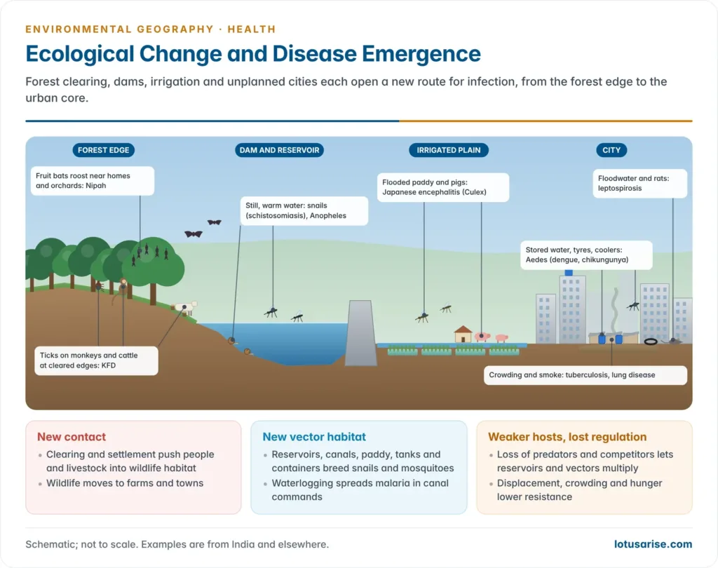
- He read diseases as complexes of factors: a two-factor disease needs only the agent and man; malaria is a three-factor complex (Plasmodium, Anopheles, man); plague is a four-factor complex (bacillus, flea, rat, man).
- The more links a complex has, the more environmental conditions it depends on, and so the more sensitive it is to ecological and climatic change.
- Melinda Meade summed up disease ecology in the triangle of human ecology: population (genetics, age, immunity), habitat (natural, built and social environment) and behaviour (culture, beliefs, technology, mobility).
- From the 1990s, health geography (a term pressed by Robin Kearns, 1993) widened the field to place, well-being, inequality and health care. Medical geography now has two linked traditions: disease ecology and health-care delivery.
- Wilbert Gesler (1992) added therapeutic landscapes: places such as spas, sacred groves, hill stations and green parks that are believed to heal. Environments can promote health as well as threaten it.
- Contact with green and blue spaces lowers stress, and loss of microbial diversity in sealed, sanitised cities is linked to rising allergic and autoimmune disease (the biodiversity hypothesis).
The disease-ecology triad: agent, host and environment
- Agent: the cause of disease, whether biological (virus, bacterium, protozoan, worm), chemical (arsenic, fluoride, particulates) or physical (heat, radiation, noise).
- Host: the human population, with its genetic make-up, age, nutrition, immunity and behaviour.
- Environment: the physical setting (climate, relief, water), the biological setting (vectors, reservoirs, vegetation) and the socio-economic setting (housing, sanitation, poverty, services).
- Disease follows a change in the balance of the triad. A warmer season lengthens the vector’s breeding period; a cleared forest brings people to infected ticks; a new reservoir creates snail habitat; malnutrition lowers host immunity.
- Hosts adapt as well. The sickle-cell trait gives partial protection against falciparum malaria and is common in malarial lowlands of Africa and India, a biological adaptation that sits beside the cultural ones of human ecological adaptation.
- Ways of transmission set the environmental controls on each disease:
| Type | Examples | Main environmental controls |
|---|---|---|
| Vector-borne | Malaria, dengue, chikungunya, Japanese encephalitis, kala-azar, KFD | Temperature, rainfall, standing water, vegetation, housing |
| Water-borne and water-washed | Cholera, typhoid, hepatitis A and E, diarrhoea | Water supply, sanitation, floods, temperature |
| Air-borne | Tuberculosis, influenza, meningitis | Crowding, ventilation, humidity, dust |
| Zoonotic (animal to human) | Nipah, rabies, avian influenza, leptospirosis | Land-use change, livestock, wildlife contact |
| Environmental non-communicable | Fluorosis, arsenicosis, COPD, heat stroke | Geology, pollution, heat, occupation |
- The epidemiological transition shifts the burden over time from infections towards non-communicable diseases. India now carries a double burden: a residual infectious load and a rising load of pollution-linked heart and lung disease.
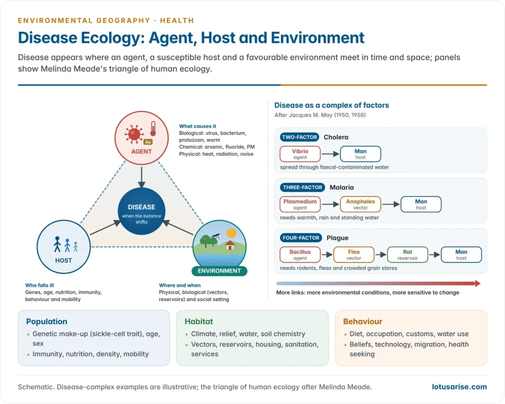
Ecological Change and Disease Emergence
Why ecological change creates disease
- Most new diseases come from animals. An analysis of 335 emerging-disease events between 1940 and 2004 found that 60.3% were zoonoses, and 71.8% of those came from wildlife (SARS and Ebola, for example).
- Emergence correlated with wildlife diversity and human population density, so the likely hotspots of new zoonoses lie mainly in tropical regions with forest frontiers and fast-growing populations.
- The IPBES workshop on biodiversity and pandemics (2020) estimated about 1.7 million undiscovered viruses in mammals and birds, of which 631,000–827,000 may be able to infect people.
- It named land-use change, agricultural expansion, wildlife trade and intensive livestock as the main drivers of spillover.
- Ecological change works through four mechanisms:
- New contact: people move into forests and wildlife into farms and towns, so the edge between them grows.
- New habitat for vectors: reservoirs, canals, paddy fields, construction pits and urban containers create breeding sites.
- Loss of regulating species: predators and competitors that once kept reservoir animals or vectors in check disappear.
- Weakened hosts: malnutrition, displacement and crowding lower resistance.
- Every regional ecological change and imbalance in land use, water or settlement therefore carries a health outcome, often delayed and felt far from its cause.
Deforestation, forest edges and spillover
- Forest edges are hotspots of transmission: the edge effect that raises species richness also mixes wildlife, vectors, livestock and people.
- Kyasanur Forest disease (KFD, “monkey fever”): a tick-borne viral haemorrhagic fever first recognised in 1957 in the Kyasanur forest of Shivamogga (Shimoga), Karnataka.
- The virus circulates among monkeys, small mammals and Haemaphysalis spinigera ticks. Its emergence followed forest clearance and cattle grazing at the forest edge, which multiplied tick hosts.
- Deaths of monkeys in the forest act as an early warning of human outbreaks. The disease has spread beyond Karnataka along the Western Ghats, helped by fragmentation and human entry into forests.
- Nipah virus: carried by fruit bats (Pteropus). In Malaysia (1998–99) it spread from bats to pigs on farms carved out of forest beside fruit orchards, and then to pig farmers, killing more than a hundred people.
- Forest loss and the drought and haze of the 1997–98 El Niño are thought to have pushed bats towards orchards and farms.
- Lyme disease in north-eastern USA: small, fragmented forest patches carry denser populations of infected ticks, because predators and alternative hosts that dilute transmission are lost.
- Forest-frontier malaria: clearing and road-building in the Amazon create sunlit pools that favour the main local vector, so malaria peaks in newly settled frontier zones.
- Deforestation thus acts on health through edge creation, vector habitat and lost dilution, not only through lost forest products.
Dams, irrigation and water development
- Large water projects replace flowing rivers with still, warm, shallow water, the habitat of snails and mosquitoes.
- Schistosomiasis (bilharzia): a worm that passes through freshwater snails.
- After the Aswan High Dam and its perennial canals, schistosomiasis rose in Egypt’s irrigated lands.
- In the Senegal River Basin, the Diama barrage (built to keep out sea water) made the lower river fresh and alkaline. Snails multiplied, migratory prawns that ate them were blocked, and intestinal schistosomiasis spread into the valley.
- Worldwide, nearly 400 million people live where dams have blocked snail-eating river prawns and raised schistosomiasis risk (2017 estimate).
- Malaria in the Thar: before canal irrigation, malaria in western Rajasthan was unstable and seasonal. Canal water, seepage and waterlogging in the Indira Gandhi Canal command, along with uncovered rainwater tanks (tanka), sustained Anopheles breeding; malaria in Rajasthan peaked in 1976 and 1996.
- Japanese encephalitis (JE): its vector Culex tritaeniorhynchus breeds in flooded paddy fields, and pigs amplify the virus. The spread of irrigated rice and pig-rearing in eastern Uttar Pradesh, Bihar and Assam created the JE and acute encephalitis belt centred on Gorakhpur.
- Waterlogging and salinity in canal commands also bring malaria, and polluted return flows carry nitrate and pesticide.
- Disease is thus one of the hidden environmental impacts of large dams, alongside displacement and sedimentation.
Urbanisation
- Cities concentrate people, waste and heat, and they create new vector habitats.
- Aedes aegypti breeds in clean water held in containers: stored drinking water, coolers, tyres, construction sites and roof tanks. Unplanned growth with intermittent water supply makes dengue and chikungunya urban diseases.
- Chikungunya returned to India in 2006 after about three decades with more than a million suspected cases.
- Anopheles stephensi, the urban malaria vector, breeds in overhead tanks, wells and construction sites.
- Leptospirosis surges after urban floods, when rat urine mixes with floodwater; Mumbai and Kerala record outbreaks after heavy monsoon flooding.
- Crowded, poorly ventilated slums sustain tuberculosis and respiratory infections.
- Urban heat islands add several degrees to night temperatures, prolonging heat stress, and pollution domes trap traffic and industrial emissions over the city.
Agriculture, livestock and chemicals
- Intensive livestock in dense sheds lets viruses such as avian influenza (H5N1) move between wild birds, poultry and people. Routine antibiotic use in animals adds to antimicrobial resistance.
- Agrochemicals: nitrate in groundwater causes methaemoglobinaemia in infants, and persistent pesticides biomagnify in food chains, part of the wider burden of environmental pollution.
- Crop and diet change: in the litchi orchards of Muzaffarpur (Bihar), acute encephalopathy in malnourished children who ate litchi on an empty stomach was traced to hypoglycin A and methylenecyclopropylglycine (MCPG) in the fruit, which cause severe low blood sugar.
- It shows the triad in one place: an agent in the fruit, a host weakened by undernutrition and fasting, and an orchard environment with a harvest season.
Regional ecological change and human health
- Each region’s dominant ecological change produces its own health signature:
| Region | Ecological change | Health effects |
|---|---|---|
| Western Ghats and Kerala | Forest fragmentation, plantations, bat roosts near homes | KFD, Nipah, leptospirosis, dengue |
| Indo-Gangetic Plain | Groundwater over-use, stubble burning, dense cities | Arsenicosis, winter smog, respiratory disease, heat |
| Thar and Indira Gandhi Canal command | Canal irrigation, waterlogging | Malaria outbreaks, salinity stress |
| Deccan and hard-rock plateaus | Deep borewells in fluoride-rich granite and gneiss | Dental and skeletal fluorosis |
| Himalaya | Deforestation, glacier retreat, road cutting, warming | Landslide and flood injury, water scarcity, vector spread uphill |
| Aral Sea basin | Lake desiccation by irrigation diversion | Salt and dust storms, respiratory and kidney disease, anaemia |
| Sahel | Drought, land degradation | Malnutrition; meningitis epidemics in the dusty dry season |
- The common thread: a change in land, water or vegetation alters exposure (new contact), habitat (vectors, pathogens) or resistance (nutrition, water and income), and health follows.
- Mountain ecosystems are especially sensitive: thin soils, steep slopes and tightly stacked climate belts mean that small changes shift vector zones and hazards.
One Health
- One Health treats the health of people, animals, plants and ecosystems as one interdependent system.
- Its roots lie in the Manhattan Principles (2004), framed at a “One World, One Health” meeting in New York.
- The One Health High-Level Expert Panel defines it as an integrated, unifying approach to balance and optimise the health of people, animals and ecosystems.
- The Quadripartite of FAO, UNEP, WHO and WOAH (formalised in 2022) runs the One Health Joint Plan of Action (2022–2026), with tracks on zoonoses, endemic and vector-borne diseases, food safety, antimicrobial resistance and the environment.
- In practice:
- Joint surveillance: monkey deaths for KFD, bat sampling for Nipah, poultry deaths for avian influenza.
- Land-use planning that keeps buffers at forest edges.
- Livestock biosecurity and prudent antibiotic use.
- Conservation as disease prevention: intact ecosystems and predators dilute transmission.
- It also answers the human–wildlife conflict at the forest edge from a health angle: the same interface that brings crop raids brings spillover.
Climate Change and Health: The IPCC Assessment
What the IPCC concluded
- The IPCC Sixth Assessment Report, Working Group II (2022) treats health in Chapter 7, Health, Wellbeing and the Changing Structure of Communities, led by Guéladio Cissé and Robert McLeman.
- Observed impacts:
- Climate change has already harmed physical and mental health worldwide (very high confidence). Extreme heat has raised death and illness in all regions.
- Climate-related food-borne and water-borne diseases have increased, including diarrhoea and cholera after heat, heavy rain and floods (very high confidence).
- Vector-borne diseases have increased through range expansion and faster vector breeding (high confidence). Dengue, chikungunya and Lyme disease vectors have spread.
- Global malaria has fallen through control, but malaria has shifted to higher altitudes as the climate warms (very high confidence). Studies in the highlands of Ethiopia and Colombia found malaria reaching higher elevations in warmer years.
- Animal and human diseases, including zoonoses, are emerging in new areas.
- Projected risks:
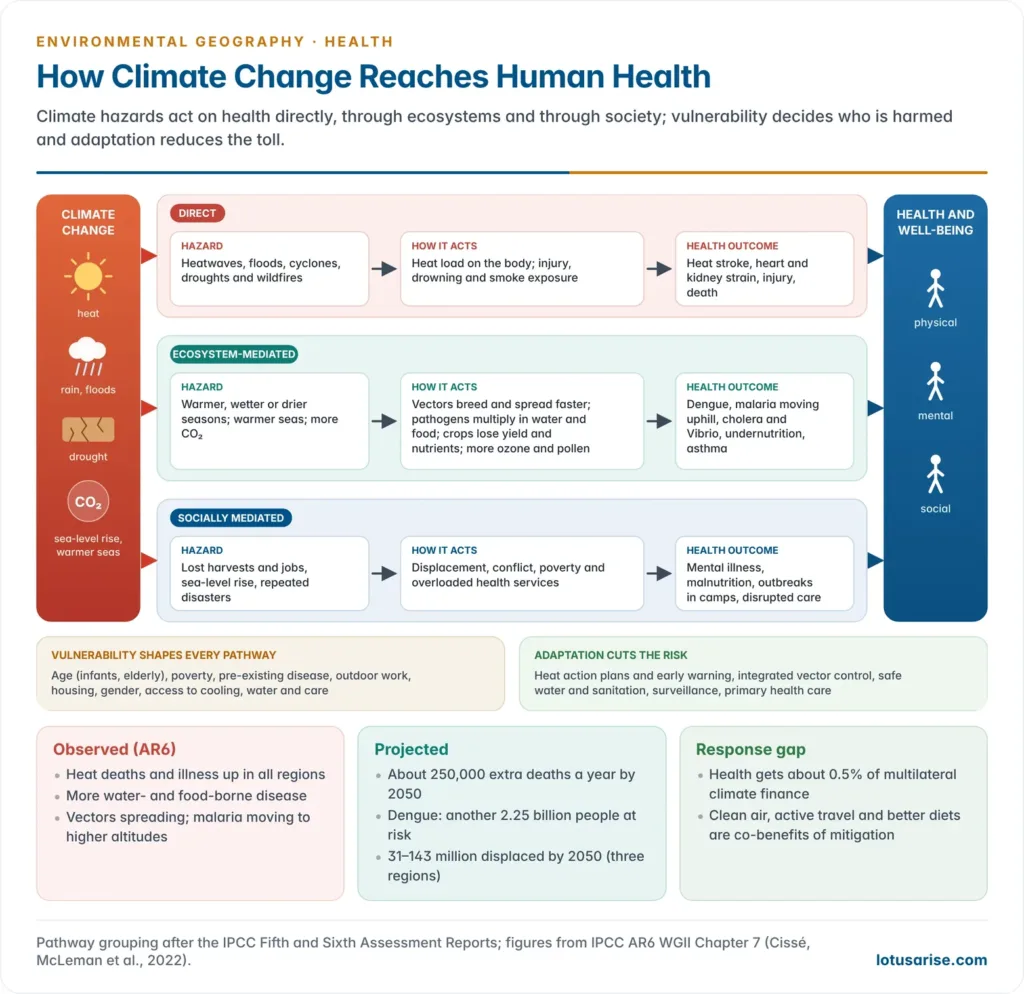
- An excess of 250,000 deaths a year by 2050 from heat, undernutrition, malaria and diarrhoeal disease, more than half of them in Africa.
- Dengue spreading with longer seasons and wider range, potentially putting another 2.25 billion people at risk.
- Climate-related displacement of 31–143 million people by 2050 in Latin America, sub-Saharan Africa and South Asia; flood displacement risk rises by about 50% for each degree of warming.
- Mental health risks from heat, extreme events, displacement and loss of livelihoods.
- Adaptation gap: health receives only about 0.5% of multilateral climate finance.
Pathways from climate change to health
- The pathways are grouped into three kinds, a scheme used since the IPCC Fifth Assessment Report (2014):
| Pathway | Climate hazard | Health outcome |
|---|---|---|
| Direct | Heatwaves, floods, cyclones, droughts, wildfires | Heat stroke, heart and kidney strain, drowning, injury, smoke-related lung disease |
| Ecosystem-mediated | Warmer, wetter or drier conditions; sea-surface warming; CO₂ rise | Vector-borne and water-borne disease, aeroallergens, ozone, undernutrition, poorer crop nutrition |
| Socially mediated | Lost livelihoods, migration, conflict, overloaded health systems | Mental illness, malnutrition, disrupted care, outbreaks in camps |
- Vulnerability modifies every pathway: age, poverty, pre-existing disease, outdoor work, housing, gender and access to cooling and care decide who falls ill.
- About 3.3–3.6 billion people live in contexts highly vulnerable to climate change, concentrated in South Asia, sub-Saharan Africa and small island states.
- Climate injustice: the people who emit least, the rural poor of the tropics, face the largest health losses and have the least capacity to adapt. Within cities, slum dwellers, the homeless and informal workers carry most of the heat burden.
Heat
- Heat is the most direct and fastest-growing climate health risk.
- Across 732 locations in 43 countries, 37% of warm-season heat-related deaths (1991–2018) were attributable to human-induced warming.
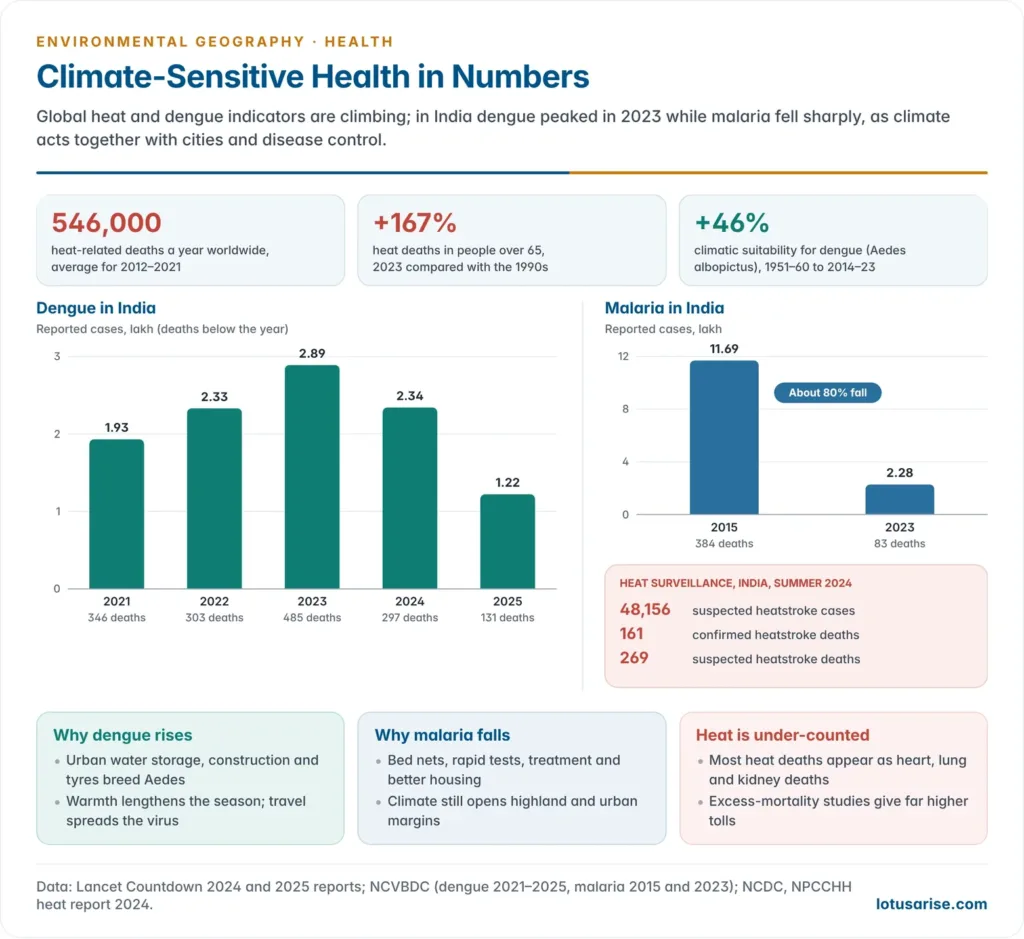
- The Lancet Countdown 2024 found heat-related deaths among people over 65 in 2023 were 167% higher than in the 1990s.
- The Lancet Countdown 2025 estimated 546,000 heat-related deaths a year in 2012–2021 (about one a minute), with the heat mortality rate up 23% since the 1990s. Heat cost about 640 billion potential labour hours in 2024.
- The physiological limit:
- Steven Sherwood and Matthew Huber (2010) argued that a wet-bulb temperature of 35°C sustained for hours is the upper limit of human survival, because sweat can no longer cool the body.
- Weather stations along the Persian Gulf and in the Indus valley of Pakistan have already briefly reported 35°C.
- Laboratory work in 2022 put the real limit for young, healthy adults nearer 31°C, so humid heat is dangerous well below 35°C.
- Who suffers: the elderly, infants, pregnant women, outdoor workers (farm, construction, street vending), people with heart and kidney disease, and slum dwellers under tin roofs.
- India:
- The May 2010 heatwave in Ahmedabad (peak 46.8°C) caused about 1,344 excess deaths, a 43% rise in all-cause mortality over the same month in adjacent years.
- Ahmedabad responded with South Asia’s first Heat Action Plan (2013): a seven-day probabilistic forecast, colour-coded alerts, cool shelters and water points, trained health workers, outreach to slum communities and cool roofs. An evaluation estimated about 1,190 deaths avoided a year in 2014–15.
- The National Disaster Management Authority issued heat-wave guidelines (2016, revised 2019), and heat action plans have spread to many states and cities.
- Under the National Programme on Climate Change and Human Health, heat surveillance in 2024 logged 48,156 suspected heatstroke cases and 161 confirmed heatstroke deaths (with 269 more suspected). Such counts understate true heat mortality, which shows up as excess deaths from heart, lung and kidney disease.
Vector-borne diseases
- Temperature controls the breeding rate and biting of mosquitoes and the incubation of the parasite inside them; rainfall and humidity control breeding sites and survival. Warming therefore lengthens transmission seasons and pushes ranges poleward and uphill.
- Dengue is the clearest case:
- The Lancet Countdown 2024 found that climatic suitability for dengue transmission rose about 46% for Aedes albopictus and more than 10% for Aedes aegypti between 1951–1960 and 2014–2023.
- The 2025 report put the global rise in dengue transmission potential at up to 49% since the 1950s.
- 2023 set a record of more than 6.5 million reported cases worldwide.
- Malaria shows that climate is not the only driver. Control, housing, bed nets and treatment have cut malaria sharply even as climate grew more favourable, but warming opens highland and higher-latitude margins.
- Ticks and sandflies: Lyme disease has moved north in Canada and Scandinavia, and warming and forest change extend tick-borne KFD along the Western Ghats.
- Climate interacts with land use and urbanisation. Dengue rises fastest where warming meets unplanned cities, water storage and travel.
Water-borne and food-borne diseases
- Heavy rain and floods overflow sewers and contaminate wells, triggering diarrhoea, cholera, typhoid and hepatitis. Droughts concentrate pathogens and force use of unsafe sources.
- Warmer water favours Vibrio bacteria (cholera and wound infections) along low-salinity coasts, and harmful algal blooms that poison shellfish.
- Higher temperatures speed the growth of Salmonella and Campylobacter in food.
- Leptospirosis follows floods; after the August 2018 Kerala floods, the state recorded a sharp leptospirosis outbreak.
Nutrition and food security
- Heat, drought and floods cut yields and incomes, raising undernutrition, especially among children and pregnant women.
- The Lancet Countdown linked 124 million more people facing moderate or severe food insecurity in 2023 to heatwaves and drought.
- Rising CO₂ lowers food quality: C3 grains and legumes (wheat, rice, pulses) grown at mid-century CO₂ levels contain less zinc and iron, and C3 cereals less protein. This threatens people who already lack these nutrients.
- Fisheries decline with ocean warming, removing a protein source for coastal communities. The wider chain of food and nutrition problems runs through climate.
Air quality, extremes, displacement and mental health
- Chronic disease: repeated heat stress and dehydration strain the kidneys and heart. Heat stress is a suspected cause of the chronic kidney disease of unknown cause seen among farm workers in hot lowlands of Central America and Sri Lanka, and studied in the Uddanam coast of Andhra Pradesh.
- Air quality: heat speeds ground-level ozone formation; drought and heat raise wildfire smoke (a record 154,000 deaths in 2024); longer pollen seasons worsen allergies and asthma; dust storms grow with land degradation.
- Fossil-fuel combustion that drives warming also causes about 2.5 million deaths a year from outdoor air pollution, so mitigation brings immediate health co-benefits.
- Extreme events cause injury, drowning and the collapse of health services. Since 2008, weather-related disasters have displaced over 20 million people a year internally.
- Mental health: anxiety, depression and post-traumatic stress follow floods, cyclones and fires.
- Heat raises suicide rates and violence.
- Loss of a familiar landscape produces solastalgia, a term coined by Glenn Albrecht (2005).
Adaptation and co-benefits
- Effective measures named by the IPCC: heat action plans with early warning, integrated vector management, safe water and sanitation, climate-informed disease surveillance, and universal primary health care that includes mental health.
- Health co-benefits of mitigation: cleaner air from leaving coal, active transport (walking, cycling), and healthier, plant-rich diets. Their value can exceed the cost of mitigation.
- India’s health response:
- The National Programme on Climate Change and Human Health (NPCCHH, 2019), run by the National Centre for Disease Control, is the health mission of the National Action Plan on Climate Change.
- It covers heat, air pollution, vector-borne and water-borne disease, extreme events and nutrition.
- It has taken over the heat-related illness and death surveillance begun in 2015.
- 34 states and UTs have prepared state action plans on climate change and human health.
- It promotes heat-stroke rooms in hospitals, green and climate-resilient health facilities, and early warning drawn from IMD forecasts.
- The National Programme on Climate Change and Human Health (NPCCHH, 2019), run by the National Centre for Disease Control, is the health mission of the National Action Plan on Climate Change.
India: Environmental Health Burdens
Air pollution
- Air pollution is India’s largest environmental health risk. The India State-Level Disease Burden Initiative (ICMR with the Global Burden of Disease study) found:
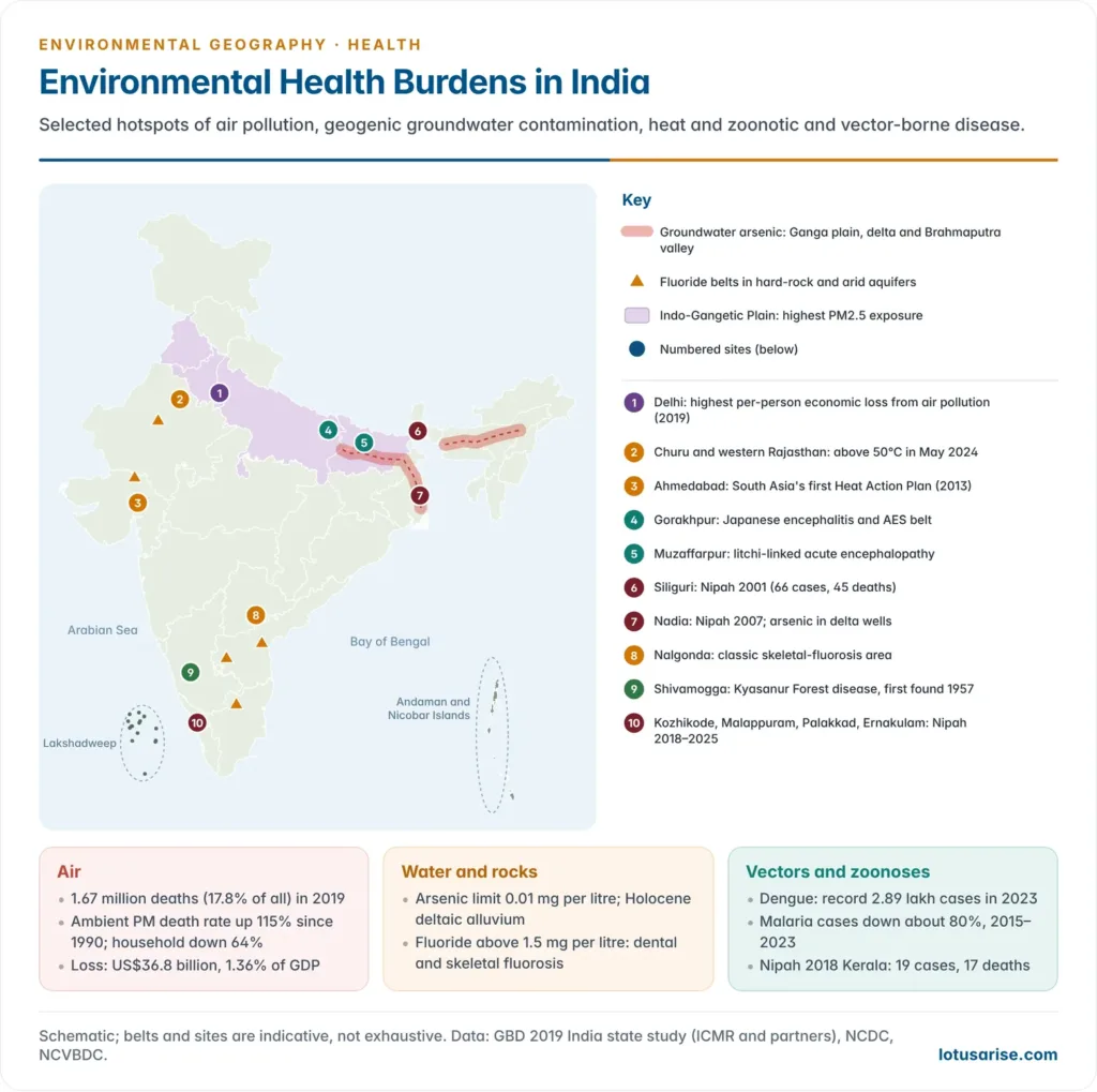
- 1.67 million deaths in 2019, 17.8% of all deaths in the country;
- 0.98 million from ambient particulate matter and 0.61 million from household air pollution (solid cooking fuels);
- between 1990 and 2019 the death rate from household pollution fell 64%, while that from ambient PM rose 115% and from ozone 139%, a shift from kitchen smoke to outdoor smog;
- a loss of US$36.8 billion (1.36% of GDP) in output, proportionally highest in Uttar Pradesh, Bihar, Rajasthan, Madhya Pradesh and Chhattisgarh; Delhi has the highest loss per person.
- Geography: the Indo-Gangetic Plain is the worst affected.
- Low winter mixing heights and temperature inversions trap pollutants, and the plain’s northern edge is closed by the Himalaya.
- Sources include crop-residue burning, brick kilns, vehicles, industry and biomass fuel.
- Health effects: stroke, ischaemic heart disease, chronic obstructive pulmonary disease, lung cancer, lower respiratory infections, low birth weight and diabetes.
Groundwater arsenic and fluoride belts
- Arsenic is geogenic: it is released from iron oxides in young Holocene alluvium of the Ganga–Brahmaputra–Meghna system when reducing groundwater dissolves them.
- First recognised in West Bengal in the early 1980s, it affects the Bhagirathi–Hooghly delta, the middle Ganga plain of Bihar (Bhojpur, Patna, Vaishali, Saran) and eastern Uttar Pradesh, the Sahibganj tract of Jharkhand and the Brahmaputra valley of Assam.
- The safe limit is 0.01 mg per litre (BIS and WHO).
- Long exposure causes arsenicosis: skin pigmentation and keratosis, then cancers of the skin, lung and bladder.
- Across the border, contamination of tube wells in Bangladesh has been called the largest mass poisoning of a population in history.
- Fluoride comes from fluorine-bearing minerals (fluorite, apatite, micas) in granites and gneisses and from alkaline, arid groundwater.
- Belts lie in Rajasthan, north Gujarat, Telangana (Nalgonda is the classic area), Andhra Pradesh (Prakasam, Anantapur), Karnataka, Tamil Nadu (Dharmapuri) and Haryana and Punjab.
- Above 1.5 mg per litre it causes dental fluorosis (mottled teeth), then skeletal fluorosis (stiff, deformed bones) and crippling.
- Human action deepens the problem: deeper borewells tap more mineralised water, and groundwater depletion can mobilise arsenic.
- The groundwater crisis of the Indo-Gangetic Plain is also a health crisis.
- Nitrate from fertiliser and sewage, and uranium reported in parts of Punjab’s aquifers, add to the load.
- Responses: safe surface-water piped supply under the Jal Jeevan Mission (2019), which prioritises quality-affected habitations; community defluoridation (Nalgonda technique) and arsenic-removal plants; arsenic-safe deep aquifers; and the National Programme for Prevention and Control of Fluorosis.
Vector-borne diseases: a shifting map
| Disease | Recent trend in India | Environmental link |
|---|---|---|
| Dengue | 2.89 lakh cases and 485 deaths in 2023 (a record); 2.34 lakh in 2024; 1.22 lakh in 2025 | Urban water storage, construction, warmth, monsoon; now reported from almost every state |
| Malaria | 11.69 lakh cases (2015) → 2.28 lakh (2023), an 80% fall; India left the WHO high-burden group in 2024 | Forest and tribal belts of Odisha, Chhattisgarh, Jharkhand and the North-East; irrigation; urban An. stephensi |
| Kala-azar | Elimination target (under 1 case per 10,000 in every block) reached in 2023 | Sandflies in damp mud houses of the Bihar–Jharkhand–Bengal plains |
| Japanese encephalitis and AES | Endemic in eastern UP, Bihar, Assam | Paddy irrigation and pig-rearing |
| Kyasanur Forest disease | Spreading along the Western Ghats | Forest fragmentation, tick hosts |
- The two mosquito diseases have moved in opposite directions. Urban dengue has risen steeply since the late 2000s, while malaria, which yields to rural control, has fallen.
- In 2024 the largest dengue loads were in Karnataka, Tamil Nadu, Kerala and Maharashtra, and Kerala recorded the most deaths.
- India targets zero indigenous malaria by 2027 and malaria elimination by 2030 under its national framework.
Zoonoses: Nipah in Kerala and Bengal
| Year | Place | Cases | Deaths |
|---|---|---|---|
| 2001 | Siliguri, West Bengal | 66 | 45 |
| 2007 | Nadia, West Bengal | 5 | 5 |
| 2018 | Kozhikode and Malappuram, Kerala | 19 | 17 |
| 2019 | Ernakulam, Kerala | 1 | 0 |
| 2021 | Kozhikode, Kerala | 1 | 1 |
| 2023 | Kozhikode, Kerala | 6 | 2 |
| 2025 | Malappuram and Palakkad, Kerala | 4 | 2 |
- Further fatal cases occurred in Malappuram in 2024. Phylogenetic study of the 2018 outbreak traced the virus to Pteropus medius fruit bats, and no intermediate animal has been found in India.
- Why Kerala: dense settlement interspersed with homestead orchards and fruit trees, large bat roosts close to houses, and a strong surveillance system that detects cases others might miss.
- Human-to-human spread in hospitals made the 2001 Siliguri and 2018 Kozhikode outbreaks severe. Kerala’s response, with contact tracing, containment zones and bat surveillance, is a working example of One Health.
Heat waves
- India’s heat waves are growing longer, more frequent and more humid. The Indo-Gangetic Plain, central India and the eastern coast are most exposed.
- In 2024 temperatures crossed 50°C in parts of Rajasthan.
- Coastal Odisha and Andhra Pradesh, with high humidity, carry a heavy heat-death toll even at moderate temperatures.
- Urban heat islands raise night temperatures in cities such as Delhi, Ahmedabad and Nagpur, removing night-time relief. Outdoor workers in fields and construction lose income and health together.
Geographical tools for environmental health
- Disease mapping and GIS: plotting cases by place and season finds clusters and hotspots, the method John Snow began; India’s Integrated Health Information Platform (IHIP) now reports disease data digitally in near real time.
- Remote sensing: satellite data on rainfall, land surface temperature, vegetation (NDVI) and water bodies map mosquito breeding habitats and forest edges, and track urban heat islands and aerosol (PM2.5) cover.
- Climate-based early warning: IMD forecasts trigger heat alerts, and rainfall and temperature anomalies are used to forecast malaria and dengue seasons weeks ahead.
- Health impact assessment applies the same logic before a dam, mine, canal or township is built, so that new vector habitats and pollution exposures are designed out.
- Vulnerability mapping overlays exposure (heat, arsenic, floods) with sensitivity (age, poverty, housing) and adaptive capacity (clinics, water, cooling) to target action at district and ward level.
Policy response in India
| Measure | Year | Focus |
|---|---|---|
| National Goitre Control Programme (renamed NIDDCP in 1992) | 1962 | Iodised salt against iodine deficiency |
| Ahmedabad Heat Action Plan | 2013 | First heat-health early warning plan in South Asia |
| National Framework for Malaria Elimination | 2016 | Malaria elimination by 2030 |
| National Clean Air Programme | 2019 | PM reduction in non-attainment cities |
| National Programme on Climate Change and Human Health | 2019 | Climate-sensitive illness: heat, air, vectors, water, extremes |
| Jal Jeevan Mission | 2019 | Safe piped water; priority to arsenic and fluoride habitations |
- Gaps:
- Under-counting of heat deaths.
- Weak links between environmental, veterinary and health data.
- Urban planning that ignores vector habitats.
- Groundwater policy that treats quality and quantity separately.
- Thin adaptation finance for health.
- The way forward is to treat land, water and climate decisions as health decisions:
- Health impact assessment of projects;
- forest-edge and wetland buffers;
- climate-informed disease early warning;
- cool, ventilated housing;
- clean cooking fuel;
- and a working One Health system at district level.
Previous Year Questions
2026Write an essay on disease and global warming according to the report of Intergovernmental Panel on Climate Change (IPCC).2024Health is the outcome of interaction between physical setting, cultural traits and ecological connection. Explain.2023What are the factors affecting regional ecological changes ? How do these affect human health ?2022Groundwater contamination in the fast expanding urban landscape of India appears to have become a major public health issue. Discuss.




