

- Classifying settlements brings order to the variety of human habitation, from the isolated homestead to the megalopolis. It helps explain their structure, function and spatial organisation, and it is the basis of planning and statistics.
- Settlements can be classified by size, form, shape, function, site, origin and administrative status. Of these, function is the most meaningful, because the nature and complexity of functions shape both the morphology and the socio-economic character of a place.
- The oldest division, rural versus urban, is increasingly seen as a continuum rather than a sharp break. Yet governments still need a line, and each country draws it differently. India’s Census uses statutory towns and census towns.
Bases and Approaches of Classification

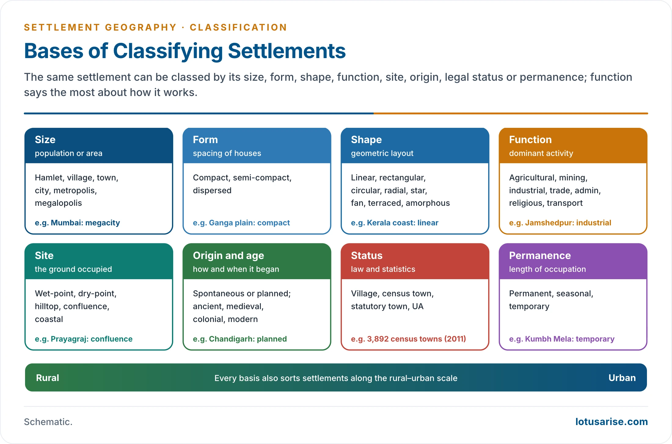
Bases of Classification
- Size: population or area, giving the sequence hamlet → village → town → city → metropolis → megalopolis.
- Form: the spacing of dwellings: compact, semi-compact or dispersed.
- Shape (morphology): the geometric layout in relation to roads, rivers and relief: linear, rectangular, circular, radial, star-shaped and others.
- Function: the dominant activities: agricultural, mining, manufacturing, trading, administrative, religious, transport or residential.
- Site: wet-point, dry-point, hilltop, confluence, coastal; set out with the components of a settlement.
- Origin and age: ancient, medieval, colonial and modern; spontaneous or planned.
- Administrative and statistical status: village, census town, municipality, corporation, cantonment.
- Permanence: permanent, semi-permanent (seasonal) and temporary.
- A settlement dominated by manufacturing and large-scale trade differs sharply in structure from a small administrative town or a farming village. Functional classification is therefore more dynamic and realistic than one based only on size or form.
Purposes of Classification
- Description and comparison: grouping similar places lets geographers compare regions and countries.
- Explanation: classes reveal the links between site, form, function and size, the raw material of theory.
- Planning and service delivery: schools, hospitals, markets and transport are planned for classes of settlement, from villages and census towns to Class I cities.
- Statistics and governance: the rural–urban line decides which body governs a place, which schemes reach it and how urbanisation is measured.
Quantitative and Qualitative Approaches
- Quantitative (statistical) methods use occupational structure, population size and composition, and economic indicators.
- They give precise and replicable classes, for example in the functional classification of towns by Chauncy Harris (1943), Howard Nelson (1955) and Ashok Mitra (1964).
- They need a large and reliable database, which is often missing for small settlements.
- Qualitative (empirical) methods use field observation and functional interpretation.
- They are indispensable for rural settlements in developing countries, where data are thin.
- Multi-criteria and geospatial methods now combine census variables with satellite data on built-up area, night-time lights and density grids, as in the UN’s Degree of Urbanisation.
- Both converge on one idea: functional complexity is the key to settlement hierarchy and classification.
Origin, Age and Permanence
- By origin:
- Spontaneous (organic) settlements grew without a plan around a village core, a temple or a market: old Varanasi, the walled quarters of Old Delhi.
- Planned settlements were laid out at one time by a ruler, a company or a state: Jaipur (1727), Jamshedpur, Chandigarh, Navi Mumbai.
- By age: ancient (Harappan, early historic), medieval (temple, fort and Mughal towns), colonial (ports, cantonments, hill stations, railway towns) and post-independence (steel towns, state capitals, new towns).
- By permanence:
- Permanent villages and towns occupied all year.
- Semi-permanent settlements of shifting cultivators (jhum hamlets in the north-east) and seasonal summer villages of pastoralists.
- Temporary camps of nomads, construction workers and pilgrims; the tent city of the Kumbh Mela at Prayagraj is among the largest temporary settlements on earth.
Functional Classification: Rural and Urban
The First Division
- The first broad distinction is between rural and urban settlements, by the nature and complexity of functions:
- Rural settlements perform few and simple functions, centred on primary activities: farming, fishing, forestry, animal husbandry.
- Urban settlements perform many and complex functions: manufacturing, trade, administration, transport and services.
- Urban settlements can then be divided by their degree of specialisation: industrial towns, commercial centres, administrative cities, transport nodes, religious and tourist towns. These classes, and global city rankings, are treated under the classification of urban settlements.
- Classifications that ignore function, such as grouping villages only by type or towns only by their stage of growth, are less useful because they miss the economic essence of settlements.
Rural Settlements
- Characteristics:
- Dependence on land and natural resources; open landscapes and low density.
- Little occupational specialisation; households combine several livelihoods.
- Limited infrastructure, though this is changing fast in peri-urban villages.
- Community-based social organisation, shaped by caste and kinship.
- Functional types of rural settlement:
- Agricultural villages, the great majority, in every farming region.
- Fishing villages on the coasts of Keralam (Kerala), Odisha and Gujarat and along large rivers.
- Plantation settlements: the tea-garden lines of Assam and the Nilgiris.
- Mining villages around the coalfields of Jharkhand and the mines of Odisha.
- Pastoral and forest villages: Gujjar and Gaddi hamlets in the Himalaya, forest villages in central India.
- Craft villages: weaving, pottery or metalwork centres such as Pochampally (Telangana), known for ikat weaving.
- Market and pilgrim villages that host weekly haats or shrines and serve a wider area.
- Rural settlements are often defined negatively, by what they lack compared with towns. This is increasingly inadequate as Indian villages diversify into construction, transport, trade and services.
Delineating Rural Settlements in India
- In India a village is defined in several overlapping ways:
- Cultural: the shrine of the village deity (gramadevata, such as Kshetrapal in the north, or the kaval deivam (guardian deity) of the south, among them Mariamman and Ayyanar in Tamil Nadu) marks the village’s symbolic territory and protection.
- Revenue village (mouza): a unit created for land-revenue collection, which may not match social settlements.
- Census village: the statistical unit, usually the revenue village. In the Census, every area that is not urban is rural, so the village is defined by exclusion.
- Panchayat: a gram panchayat may cover one large village or several small ones.
- Special rural forms:
- Abandoned villages, such as Kuldhara near Jaisalmer, deserted for historical, environmental or social reasons.
- Resettlement villages, such as the colonies near Haridwar and Dehradun for families displaced by the Tehri dam.
- Seasonal (transhumant) villages of pastoral groups such as the Bhotiyas and Gaddis, occupied in summer and abandoned in winter.
- Planned villages of canal colonies and refugee resettlement in Punjab after 1947.
Urban Settlements
- Characteristics:
- Dominance of secondary, tertiary and quaternary activities.
- A high degree of occupational specialisation and division of labour.
- Advanced infrastructure: transport, health, education, governance.
- Distinct functional zones: commercial, industrial, residential.
- Towns act as nodes of regional development, serving surrounding villages through markets, services and administration.
Central Place View: Function over Status
- From the standpoint of Walter Christaller’s central place theory, settlements should be classified by their functional role in a system rather than a rigid rural–urban divide.
- Examples:
- In medieval India, qasbas and ganjs were important service and market centres, though not always “urban” in administrative terms.
- Periodic markets (haats) and fairs may sit in villages yet serve regional or supra-regional functions; the Sonepur cattle fair in Bihar draws traders from far beyond its district.
- Conversely, some official towns, such as single-industry mining towns, may have little centrality, serving almost no hinterland.
- Indian rural planning applied this logic in the 1970s, grading settlements into service villages, growth points, growth centres and growth poles by the services they offered, so that investment could be placed where it served the most villages.
- Functional significance is therefore more important than administrative status in understanding the hierarchy of urban settlements.
The Rural–Urban Dichotomy and Continuum
Limits of the Dichotomy
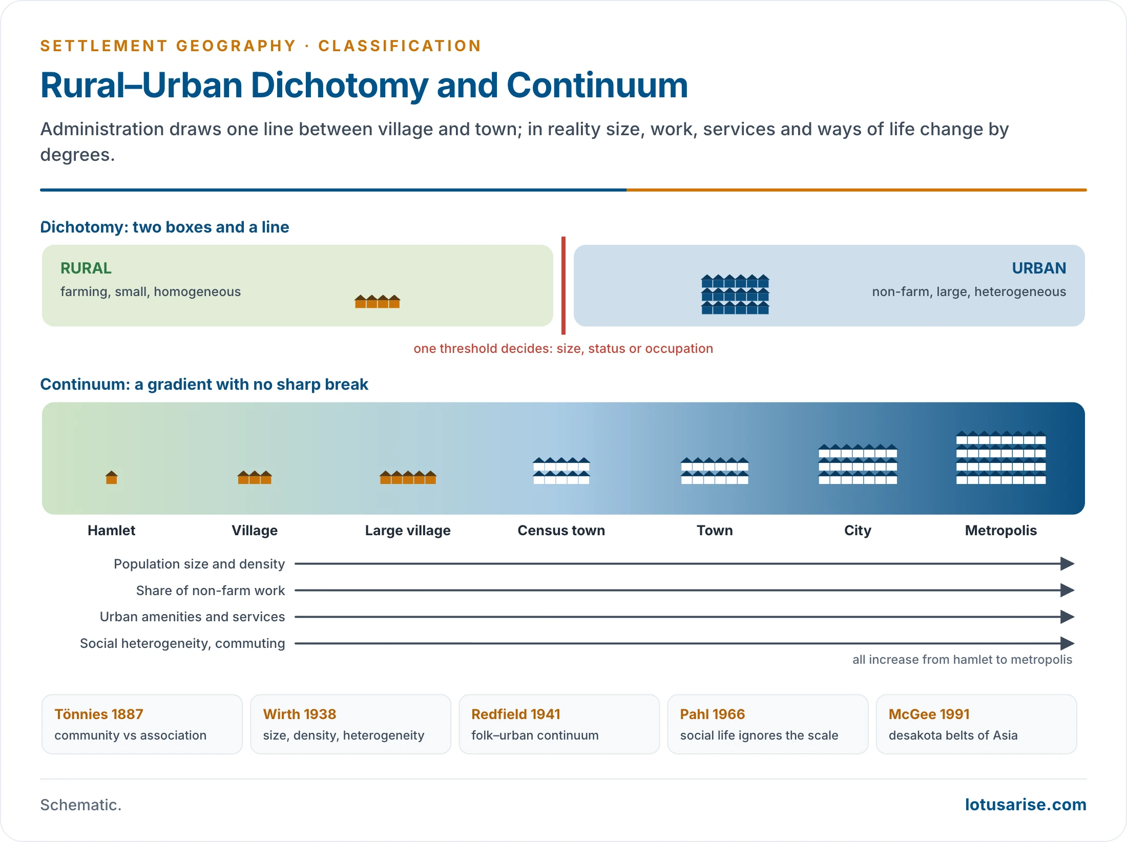
- The traditional view saw a sharp division between village and town. This rural–urban dichotomy is widely used but increasingly questioned.
- No universal criterion separates them:
- Population size is inconsistent. Some villages in India and China exceed 10,000 people, while many towns in Western Europe and North America are smaller.
- Occupation has blurred. In developed countries many rural residents work in towns, creating commuter villages and suburban villages.
- “Suitcase” or “sidewalk” farmers in the United States live in towns and travel to cultivate distant fields; rural work no longer means rural residence.
- Function is relative to region and development:
- A facility that is high-order in a developing country may be low-order in a developed one. A petrol pump, bank branch or telephone exchange is an urban marker in much of rural India but commonplace in rural America.
- Even within India, facilities common in villages of Punjab or Maharashtra are rare in rural Odisha or Chhattisgarh.
- No universal scale of functions is possible; every classification must be read in its regional and developmental context.
The Continuum Idea and its Thinkers
- The rural–urban continuum treats settlements as points along a continuous spectrum of size, density, functional complexity and way of life, with no sharp break.
- Sociological roots:
- Ferdinand Tönnies (1887): Gemeinschaft (community of kinship and neighbourhood) versus Gesellschaft (association based on contract and interest).
- Émile Durkheim (1893): mechanical solidarity of similar people versus organic solidarity of interdependent specialists.
- Pitirim Sorokin and Carle Zimmerman (1929) listed differences of occupation, environment, size, density, homogeneity, stratification, mobility and interaction, and treated them as matters of degree.
- Louis Wirth (1938) defined urbanism by size, density and heterogeneity, which produce impersonal, segmented relations.
- Robert Redfield’s folk–urban continuum (1941, 1947):
- He compared four communities in Yucatán, Mexico: a tribal village, a peasant village, a town and the city of Mérida.
- Moving towards the city, he found growing cultural disorganisation, secularisation and individualism, and declining folk traits.
- Criticism: Oscar Lewis’s restudy of Tepoztlán (1951) found conflict and individualism in the “folk” village too; the scheme romanticises village life.
- Ray Pahl’s critique (1966):
- Studying commuter villages around London, he found urban professionals and rural workers living side by side in the same village.
- He argued that social relationships cannot be tied to a place on a rural–urban scale. Class, life-cycle stage and mobility matter more than settlement type. Any continuum is therefore sociologically meaningless, though it may still describe land use and density.
- Herbert Gans (1962) made a similar point for cities: “urban villagers” keep close-knit ties inside the metropolis.
- The Indian village and civilisation: McKim Marriott (1955) applied Redfield’s idea of a great tradition (the literate, urban-centred civilisation) and little traditions (local village culture) to a village in Uttar Pradesh. Ideas flowed both ways, so village and city were linked in one cultural continuum rather than opposed.
- Geographical measures:
- Paul Cloke’s index of rurality (1977) combined census variables (density, occupations, commuting, distance from towns, age structure) to place every district of England and Wales on a graded scale from extreme rural to urban.
- Terry McGee’s desakota (1991), from the Indonesian desa (village) and kota (town), described the mixed rural–urban belts of Asia, where intensive farming, industry and dense settlement intermingle along corridors between large cities.
- In India the continuum is especially visible:
- Villages near metropolitan cities have diversified jobs, pucca housing and urban services; remote villages keep agrarian traits.
- Census towns, peri-urban belts and urban villages within Delhi’s built-up area defy strict categories.
- V. L. S. Prakasa Rao suggested that accessible large villages of 5,000–10,000 people can be more urban than equally accessible small towns. Places in this overlap, up to small towns of 20,000, are best seen as semi-rural or semi-urban.
- The Shyama Prasad Mukherji Rurban Mission (2016) develops clusters of villages with urban amenities, a policy built on the continuum.
- Indicators that place a settlement on the continuum:
- Size and density of population.
- Share of non-farm work and the variety of occupations.
- Amenities: piped water, sewerage, paved roads, banks, colleges, hospitals.
- Land use: the share of built-up, industrial and commercial land.
- Commuting and linkages with nearby towns.
- Social composition and way of life: heterogeneity, household size, consumption.
- Governance: panchayat or municipal body.
- Settlements at the two ends are easily identified. The middle zone, such as the rural–urban fringe, is where the dichotomy fails.
| Aspect | Dichotomy | Continuum |
|---|---|---|
| View of settlements | Two distinct types | Gradual change along a scale |
| Basis | One threshold (size, status) | Many variables of degree |
| Thinkers | Tönnies, Wirth (as ideal types) | Sorokin and Zimmerman, Redfield, Cloke, McGee |
| Strength | Clear for administration | Realistic for mixed zones |
| Weakness | Ignores intermediate places | Pahl: social life does not follow the scale |
Why the Dichotomy Persists
- Governments need clear and unambiguous categories for policy, budgets, taxation and elections. Panchayats and municipalities have different powers and funds.
- In India, rural status brings a place under MGNREGA, PMAY-Gramin and the Jal Jeevan Mission; urban status brings it under AMRUT, PMAY-Urban and the Swachh Bharat Mission-Urban, with municipal taxes and building rules. The line therefore has real consequences for people and budgets.
- Definitions are therefore often arbitrary and administrative, imposed by authorities rather than derived from geography.
- F. S. Hudson (A Geography of Settlements) went further: a settlement is a town simply when its inhabitants regard it as one.
- In the end, a place is a town partly because its people and its government regard it as one. The gap between theoretical understanding (a continuum) and administrative necessity (a line) remains.
Defining “Urban”: Countries and the Census of India
International Variation
- Urban criteria fall into five groups: demographic, economic, social, morphological and functional. No single criterion is enough, so most definitions combine several.
- Countries use population size, density, occupation, administrative status or urban amenities, alone or in combination:
| Country | Urban if… |
|---|---|
| Denmark, Norway, Iceland | Locality of 200 or more inhabitants |
| Canada | 1,000 or more people and 400 or more per km² |
| France | Commune with 2,000 or more people in continuous built-up area (gaps under 200 m) |
| USA (2020 Census) | Area with at least 2,000 housing units or 5,000 people |
| Israel | Settlement of over 2,000, unless a third of households live by farming |
| Japan | City (shi) of 50,000 or more with mostly urban occupations |
| Peru | Populated centre of 100 or more dwellings |
| India | Statutory town, or 5,000 people + 400 per km² + 75% male main workers outside farming |
- Hudson’s older survey grouped countries by the test they stress:
- Share of non-farm work: Israel, Italy.
- Population size: Canada, Malaysia.
- Character and compactness of the settlement: France, Germany.
- Administrative status: Britain.
- A composite of size, occupation and function: the United States.
- The urban threshold therefore ranges from 200 inhabitants (Denmark) to 50,000 (Japan), and many countries rely only on administrative status. National urban percentages are not directly comparable.
- The Degree of Urbanisation (adopted by the UN Statistical Commission in 2020) solves this with a single grid-based method:
- Cities: contiguous 1 km² cells with at least 1,500 people per km² and a total of at least 50,000.
- Towns and semi-dense areas: clusters with at least 300 per km² and at least 5,000 people.
- Rural areas: the rest.
- The UN World Urbanization Prospects 2025 used it to estimate that in 2025 45% of the world lived in cities, 36% in towns and 19% in rural areas. Towns are the most common settlement type in 71 countries, India among them.
The Census of India: History of the Definition
- Up to 1951, the Census treated as towns all municipalities, civil lines and cantonments, and other places of about 5,000 people with urban character, leaving much to the discretion of provincial superintendents.
- From 1911 the capitals of princely states counted as urban whatever their character. In 1951, after the states merged, former capitals lacking urban character were dropped.
- The 1961 Census introduced uniform demographic and economic tests: a population of 5,000, a density of about 1,000 per square mile (400 per km²) and 75% of workers outside agriculture.
- Later censuses applied the 75% test to male workers only. Plantation, livestock, forestry, fishing and allied work counted as non-agricultural in 1961 and 1971, and as agricultural from 1981. The definition has otherwise remained stable, making the series comparable over time.
Census of India 2011: Categories
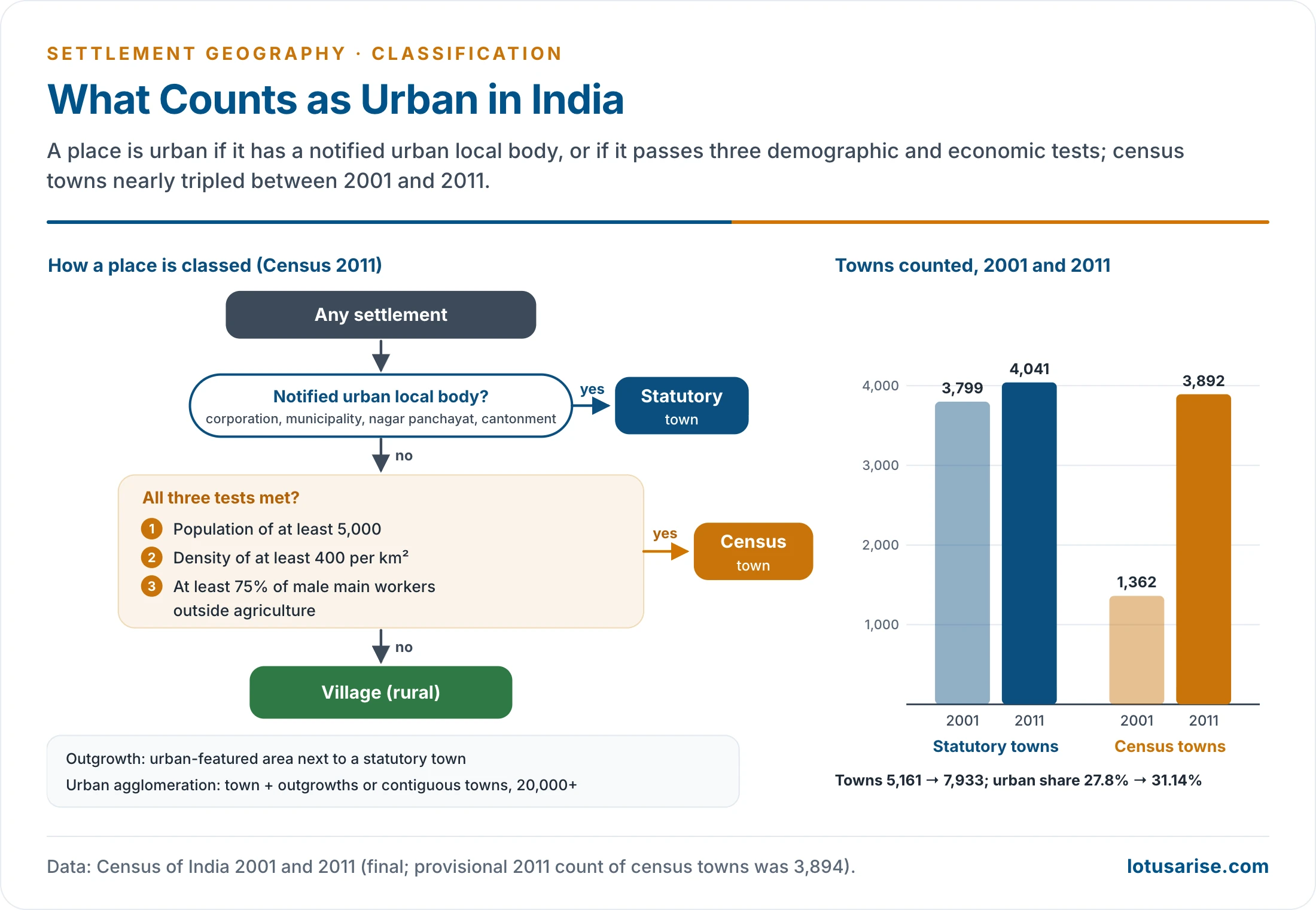
- Statutory towns (STs):
- All places with an urban local body notified under state law: municipal corporation, municipality (municipal council or committee), nagar panchayat, cantonment board, notified area committee, irrespective of population.
- Census towns (CTs): places that are administratively rural but satisfy all three criteria:
- Population of at least 5,000.
- At least 75% of the male main working population in non-agricultural pursuits.
- Density of at least 400 persons per km².
- In 2011, villages with 4,000 or more people in 2001 were screened against these tests.
- Outgrowths (OGs): villages or parts of villages contiguous to a statutory town with clear urban features (pucca roads, electricity, tap water, drainage, schools, banks): railway colonies, university campuses, port areas, military camps.
- Urban agglomeration (UA): a continuous urban spread made of a town and its outgrowths, or two or more contiguous towns. It must contain at least one statutory town and a total of at least 20,000 people. The idea replaced the Town Group of 1961 from the 1971 Census.
- Size classes of towns: Class I (1,00,000 and above), II (50,000–99,999), III (20,000–49,999), IV (10,000–19,999), V (5,000–9,999) and VI (below 5,000). Class I UAs and towns of over a million are million-plus cities; those of over 10 million are megacities on the UN measure, though Indian usage has also applied the word to cities of 5 million and above.
- The Director of Census Operations, with the state government, may also treat places with distinct urban features, such as industrial areas, large housing colonies and tourist centres, as towns. This discretion shows the flexibility and subjectivity of any classification. Critics call it arbitrary, since it makes counts of towns and urban population hard to compare between states.
Census 2011: Numbers and Issues
- 7,933 towns: 4,041 statutory towns and 3,892 census towns (final figures; the provisional count was 3,894 CTs). In 2001 there were 3,799 STs and only 1,362 CTs.
- These towns, counted together with UAs, make up an urban frame of about 6,166 UAs and towns.
- Urban population: 377 million, or 31.14% of the total; for the first time the urban increase exceeded the rural increase.
- 468 Class I UAs and towns held about 70% of the urban population; 52 million-plus UAs (final tables; 53 provisional) held about 42%; three megacities: Greater Mumbai (18.4 million), Delhi (16.3 million) and Kolkata (14.1 million).
- Regional pattern: West Bengal, Keralam and Tamil Nadu added the most census towns. Keralam’s urban share jumped from 26% in 2001 to 48% in 2011, mostly by reclassifying large, dense coastal and midland villages. Its continuous belt of houses, farms and shops is a classic rural–urban continuum.
- Census towns explain about a third of the urban growth of 2001–11 through reclassification of large villages, a sign of dispersed or “subaltern” urbanisation led by non-farm work in construction, transport and trade.
- How a place changes class: a village that crosses the three thresholds becomes a census town at the next census; it becomes a statutory town only when the state government notifies an urban local body. A census town can also fall back to rural if it fails a test at the next count.
- The churn is large. Of 4,029 towns in 1981, 93 were declassified and 103 merged with others by 1991, while 856 new towns (277 statutory, 579 census) were added.
- Issues:
- Census towns remain governed by gram panchayats, so places counted as urban lack urban local bodies, planning and municipal services.
- States often resist notifying them as statutory towns, since villages receive rural scheme funds and lower taxes, while towns face property taxes and building rules.
- Some statutory towns are below 5,000 people or largely agricultural, while some large villages are clearly urban in character.
- The male-only workforce test ignores women’s work, and the threshold of 75% is strict by world standards.
- The density test of 400 per km² is very low for India: the national average was already 382 in 2011, and 14 states and union territories exceeded 400.
- R. Ramachandran proposed different tests: 50% or more of workers outside agriculture, and a density of about 1,000 per km².
- Anomalies persist at the margins: about 2,000 places of 10,000 or more people were rural in 2001, and at least a quarter of census towns still had agriculture as the dominant activity.
- Alternative measures give a very different picture. A World Bank study using an agglomeration index of density, size and travel time to a large city (Uchida and Nelson, 2010) estimated that about 52% of India’s people lived within an hour of such a city in 2001, against an official urban share of under 28%.
- Grid-based estimates using the Degree of Urbanisation place far more of India’s people in urban-type settlements than the Census figure, because many large, dense villages count as towns.
- The next Census (houselisting in 2026, population enumeration with a reference date of 1 March 2027) will give the first count of urban India since 2011.
Classification by Size, Form and Shape
Size
- Size gives a developmental sequence of increasing population, functions and complexity: hamlet → village → town → city → metropolis → megalopolis. The progression is not always linear; many towns were founded directly for administrative, strategic or commercial reasons.
- Ancient India had its own size hierarchy. Early texts ranked settlements as kugrama (smallest), grama (village), pattana (town) and nagara (city). The Arthashastra placed a sangrahana among 10 villages, a kharvatika among 200, a dronamukha among 400 and a sthaniya among 800, a nested hierarchy of service centres.
- Hamlet: the most elementary aggregation, a small cluster of houses with no fixed size, poor communications, little infrastructure and social homogeneity, living by primary activity.
- Village: larger and better organised, with basic social and economic institutions, but still dependent on primary activities.
- Town: a qualitative change, not only a larger size.
- Built-up land dominates, and functionally differentiated zones appear: residential, commercial, administrative, industrial.
- Occupations and society become heterogeneous; the town serves as a centre of commerce and administration for its surroundings.
- Emrys Jones defined it in these terms: a physical agglomeration of houses and streets, a centre of commerce and administration, with a complex socio-economic structure and mixed occupations.
- In India the threshold is low: a town may have only 5,000 people, and the small towns of Classes IV to VI are the link between villages and cities, supplying markets, schools, courts and hospitals to their tehsils.
- City: a large and complex socio-spatial system, usually the regional hub, with diverse populations, dominance of secondary and tertiary activities and dense networks of interaction. Lewis Mumford saw the city as the highest and most complex form of associative life.
- Metropolis: a very large city with a wide sphere of influence over towns and villages, a cosmopolitan population, advanced institutions and economic and political dominance, often in the hands of commercial and financial elites. It can drive regional growth but also concentrate resources and widen inequality.
- Indian metropolises such as Mumbai, Delhi, Kolkata, Chennai, Bengaluru and Hyderabad are planned through metropolitan region development authorities that cover dozens of towns and hundreds of villages around the core city.
- Megalopolis: a vast urban region formed by the coalescence of metropolitan areas along transport corridors, a world city region of intense economic integration.
- Jean Gottmann (1961) named the Boston–Washington (BosWash) seaboard, about 700 km of linked built-up areas (960 km on wider limits), central to the growth of the US economy since the mid-20th century.
- The Tokaido belt of Japan runs from Tokyo–Yokohama through Nagoya to Osaka–Kobe–Kyoto, one of the most densely populated and economically dynamic regions of the world.
- India’s emerging candidates are the National Capital Region around Delhi and the Mumbai–Pune corridor, where built-up areas, industrial estates and satellite towns are merging.
- Such regions are treated with conurbations and metropolitan regions.
- Determinants of size:
- Rural: land fertility, water, social organisation and farming practice. Fertile river plains support large villages.
- Urban: function above all, with industry, technology, transport and administrative status.
Form
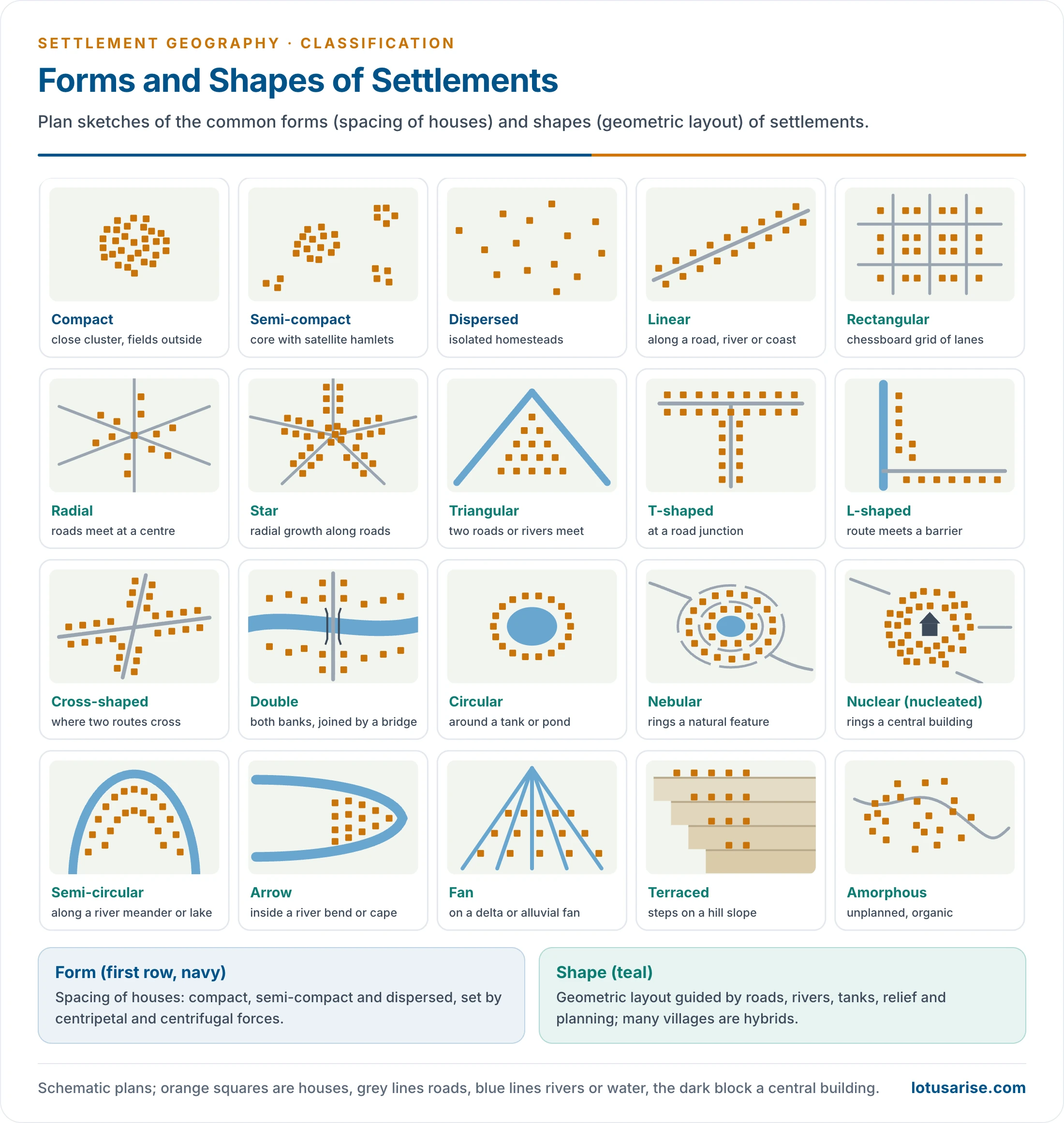
- Form describes the spacing of dwellings and reflects the balance of centripetal forces (security, cooperation, water, fertile land) and centrifugal forces (rugged terrain, scattered resources, distance to fields, social separation). Regional details are given under types of rural settlement.
- Compact (nucleated, agglomerated):
- Houses closely clustered around a centre, with fields outside.
- Favoured by level fertile land, water, defence and cooperation.
- The Ganga plain, the Punjab–Haryana plain and level parts of the Deccan.
- Semi-compact (fragmented, semi-sprinkled):
- A main cluster with satellite hamlets separated by fields, streams or uneven ground.
- Produced by physical barriers, farming needs and the caste system, with groups living in separate hamlets (tola, pura, para).
- The middle and lower Ganga plain (eastern Uttar Pradesh, Bihar, West Bengal) and the Chhattisgarh plain.
- Dispersed (scattered, sprinkled):
- Isolated homesteads or tiny clusters far apart.
- Caused by rugged relief, forests, aridity, scattered resources and a lack of security threats.
- The Himalayan slopes, the north-eastern hills, the dhanis of the Thar and parts of the Western Ghats.
- Real regions show a continuum of forms, changing with technology, population pressure and social change.
- Security, roads and electricity let families build on their fields, so compact villages throw off new hamlets (as in Punjab after consolidation of holdings).
- Population growth fills the gaps between hamlets, so semi-compact villages become compact.
Shape (Morphology)
- Shape is the geometric layout of houses in relation to roads, rivers, railways and relief. The patterns of rural settlement are measured with the nearest-neighbour index.
- Transport-based shapes:
- Linear: houses along a road, river, canal, railway, levee or coast (the Keralam coast, Himalayan valley roads). Doors usually face the road or water, and the settlement extends along it rather than outwards.
- Rectangular or chessboard: streets crossing at right angles on level plains and in planned or canal-colony villages (Punjab, Haryana).
- Radial: roads converging on a market, temple or junction, with houses along them like the spokes of a wheel; common in market villages of the plains.
- Star-shaped: a radial village that has grown outward along several roads.
- Triangular: where two roads or rivers meet without crossing.
- T, Y and L shapes: at road junctions, or where a route meets a barrier at right angles.
- Cross-shaped: where two routes cross, with houses along all four arms.
- Double: a village on both banks of a river, joined by a bridge.
- Shapes around a central feature:
- Circular: houses around a pond, tank, temple or fort; the nebular variant rings a natural feature, the nucleated variant a building. Village tanks of the Ganga plain and the Deccan often sit at the centre of such villages, with lanes running inward to them.
- Relief-based shapes:
- Semi-circular: along a river meander, an oxbow lake or a lake at the foot of a hill.
- Arrow: at the tip of a cape or on the inside of a river meander, narrowing to a point.
- Fan: spreading along distributaries in deltas and on alluvial fans.
- Terraced: in step-like tiers on mountain slopes (Himalaya).
- Amorphous (irregular): unplanned, organic growth in old villages and informal urban areas.
- Many settlements are hybrids. Shape records adaptation to physical constraints, the role of infrastructure and the evolution from simple to complex forms.
- The classification of settlements thus reflects functional, demographic, economic and administrative factors together. Function is the most meaningful basis, but regional context and data limit it, and the shift from dichotomy to continuum sits uneasily with the administrative need for a clear line.
Previous Year Questions
1997Examine the census concept of Urban areas in India.2003Discuss the census definition of urban areas in India.2009“There is no sharp divide where an urban-settlements stops and rural area begins.” Analyse the statement with reference to the sprawl of Indian cities.




