

- The rural–urban fringe is the zone of transition between the continuously built-up city and the purely rural countryside. Here urban land uses are replacing rural ones, along with occupations and ways of life.
- It is where the city meets the countryside. It lies well within the city’s sphere of influence but usually outside its administrative limits, so it is often unplanned and poorly served.
- The fringe forms through urbanisation (the physical growth of the city) and urbanism (the spread of urban lifestyles). It is shaped by urban sprawl, suburbanisation and the growth of corridors along highways.
- Sprawl here means the horizontal expansion of a city over the surrounding landscape, a natural part of urban growth. Corridors are its linear form along the main arterial roads.
Concept of the Rural–Urban Fringe

Meaning and Definitions
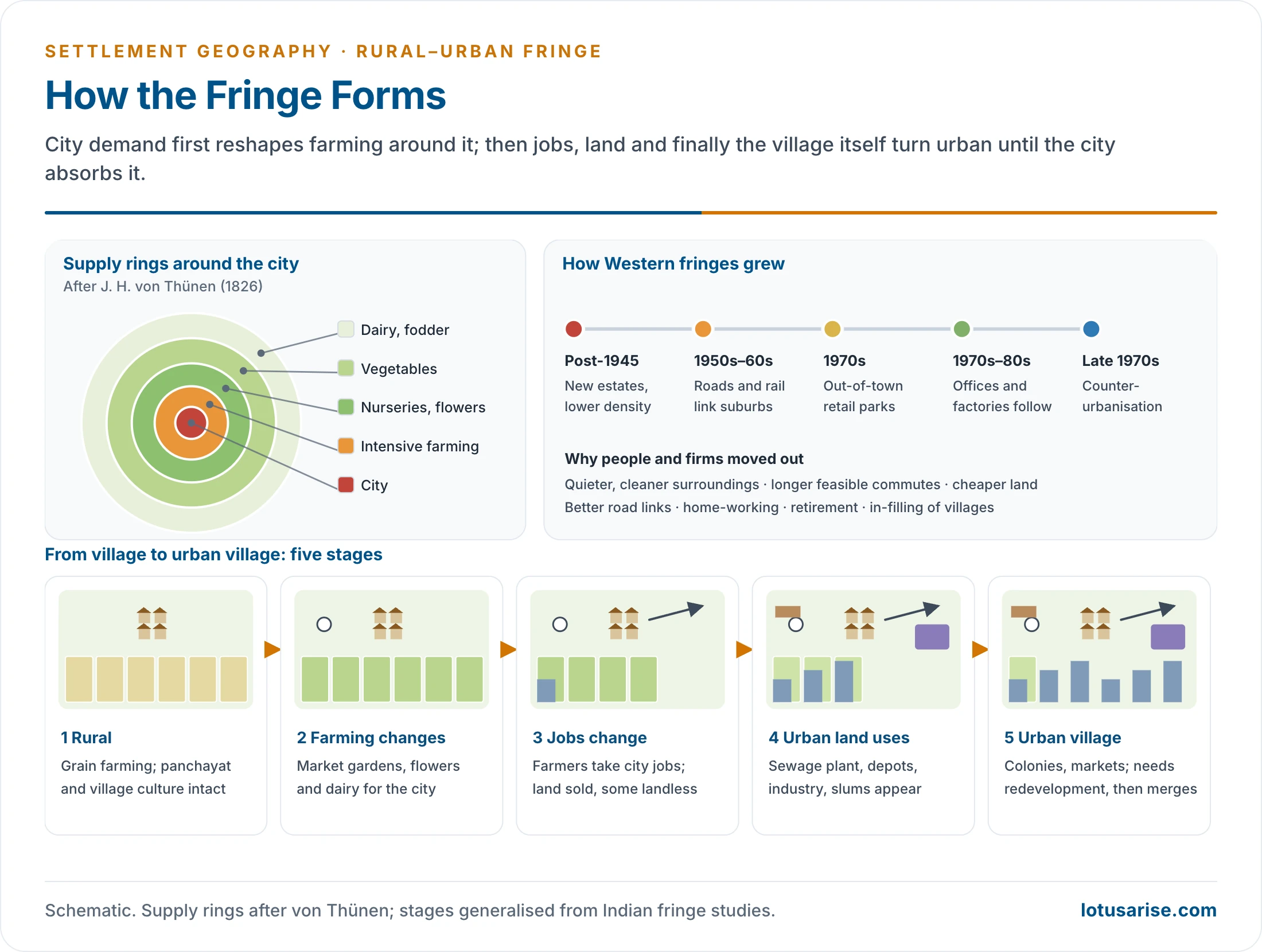
- After the Second World War, large cities spread outward. Urban corridors grew along the main highways, and suburbs, industrial suburbs and townships appeared on rural land.
- Such areas show a mixed land-use pattern: farms beside housing colonies, factories, warehouses, institutions and wasteland awaiting development.
- Key definitions:
- T. Lynn Smith (1937) first used the term “urban fringe” for the built-up area just outside a city’s administrative limits.
- George S. Wehrwein (1942) described the rural–urban fringe as a zone of transition in land use between agricultural land and the city, with suburban development spreading into it.
- Salter (1940) stressed its mixture of urban and rural land use.
- Richard B. Andrews (1942) called it the “rurban fringe”.
- Balk (1945) described it as an area of urbanisation.
- H. M. Meyer (1951), an American land economist, defined it as the transition zone between the city and rural farmland, with a mixed land-use pattern of both rural and urban practices.
- Richard A. Kurtz and Joanne B. Eicher (1958) separated the fringe, which is mixed and transitional, from the suburb, which is urban in character though outside the city.
- G. A. Wissink (1962) distinguished the fringe, the suburb and the pseudo-suburb. He also called it an area of great differentiation.
- Robin J. Pryor (1968) defined it as a complex zone of transition in land use, social and demographic characteristics between the built-up city and the rural hinterland. He split it into an urban fringe of rapid exurban invasion and a rural fringe beyond.
- Lorne Russwurm stressed that it is a discontinuous area.
- Indian views:
- R. L. Singh described it as rural land with urban phenomena.
- M. M. P. Sinha defined it as a narrow zone of varying width outside the political boundary of a town that is neither fully urban nor fully rural.
- Other names:
- Ernest Burgess’s commuters’ zone, also given as his peripheral zone, the peri-urban area, the urban shadow, exurbia and the rural–urban continuum.
- The Census of India records urban spill-over just outside a town as outgrowths (OGs); the older term is out urban area:
- railway colonies, university campuses, port areas or villages with urban features, contiguous to a statutory town.
- In 2011 there were 981 outgrowths in 474 urban agglomerations (475 in the provisional count).
- It also records growing villages that meet urban criteria as census towns. Their number rose from 1,362 in 2001 to 3,892 in 2011.
- The rural–urban fringe differs from the fringe belt of urban morphology. A fringe belt is a belt of large institutional plots that forms inside a town when its growth pauses at a wall or other fixation line. It is later surrounded by new building. The rural–urban fringe is the active edge of present-day growth.
Evolution of the Concept and the Zone
- Johann Heinrich von Thünen (1826) first described concentric belts of land use around a city:
- the most intensive and perishable produce (market gardening, milk) nearest the city;
- more extensive uses farther out.
- The modern fringe still has this supply belt.
- The Chicago School (Ernest Burgess, Robert Park, Roderick McKenzie) treated the outer edge as the commuters’ zone. Walter Christaller’s central places, Homer Hoyt and Charles C. Colby’s centrifugal forces also bear on how cities spread. Olof Jonasson, Harlan Douglass and Benton MacKaye also wrote on the city’s edge.
- The Western sequence of fringe growth:
- Rebuilding after the war could not house everyone, so new estates went up at the edge. Suburban houses were larger and density lower, because land was cheaper.
- Transport networks followed, tying the suburbs to the inner city.
- From the 1970s, out-of-town shopping centres used cheaper land and space. Offices and factories followed, for lower costs and better road links.
- From the late 1970s, many cities lost people to counter-urbanisation. People moved out for a quieter, cleaner environment, longer commutes became feasible, firms relocated, home-working grew, and retired people left.
- Small towns and villages with good links grew by in-filling: building in the gaps inside the village or town envelope.
Approaches to the Fringe
- Ecological: the fringe is the outer front of invasion and succession, where urban uses displace rural ones ring by ring.
- Economic: bid rent explains it. Urban users outbid farmers for land near the city, and farmers who remain switch to high-value, intensive crops.
- Behavioural: households and firms choose fringe locations for space, price, schools or a rural image, so the fringe reflects perception as much as distance.
- Political economy: land speculation, developers and the state’s acquisition and conversion powers decide who gains from the rising value of fringe land. The poor are often displaced.
- The fringe is part of the wider rural–urban continuum, in which settlements grade from rural to urban without a sharp break.
Structure of the Fringe
Zones of the Regional City
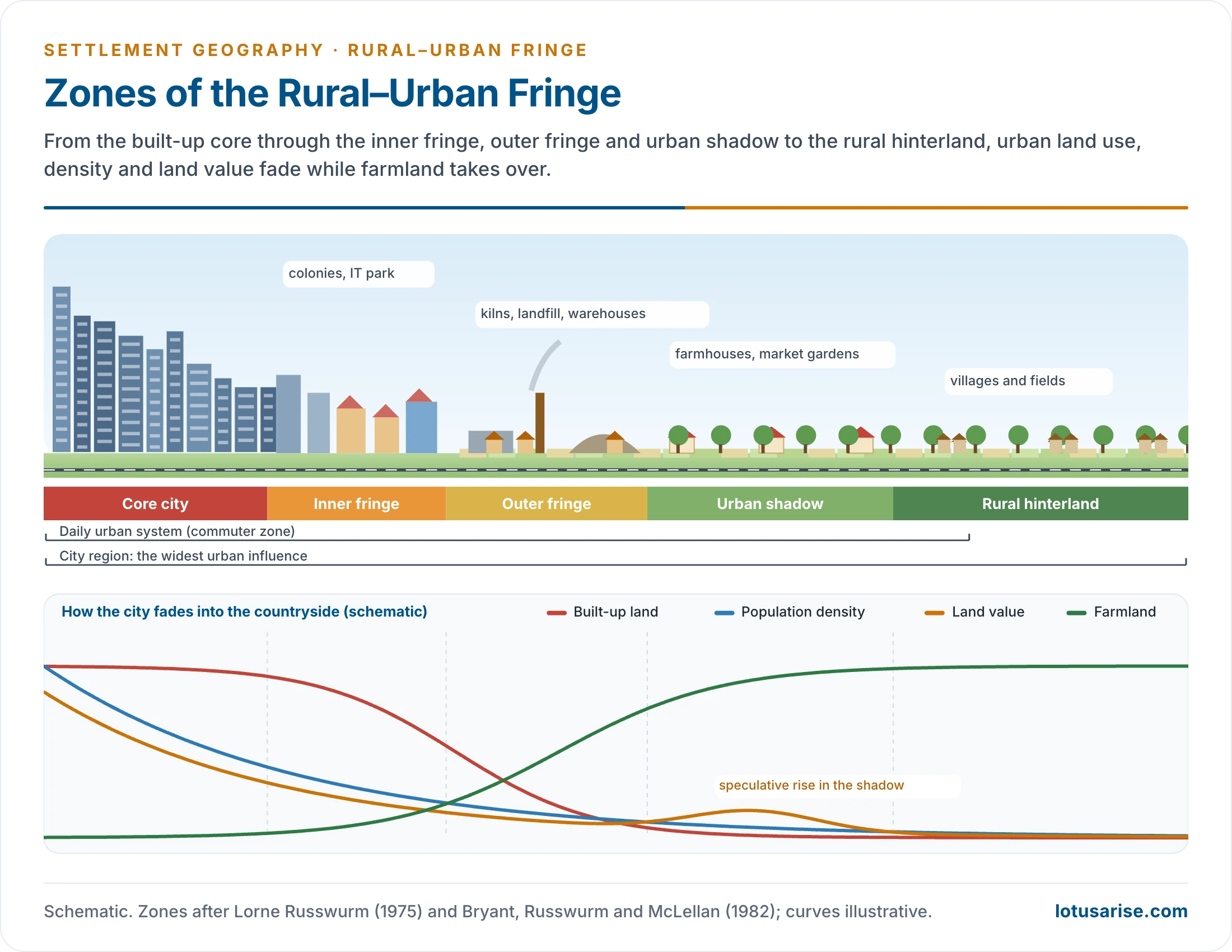
- The regional city model (Lorne Russwurm, 1975; developed by Christopher Bryant, Russwurm and A. G. McLellan, 1982) arranges the city’s countryside in zones:
- Core city: the continuously built-up area.
- Inner fringe (urban fringe):
- Land use is in an advanced stage of conversion: suburban colonies, urban corridors, industrial estates and institutions.
- Former villages become residential urban villages.
- Outer fringe (rural fringe):
- Rural land use still dominates, but urban elements are scattered through it. Occupations change faster than the landscape.
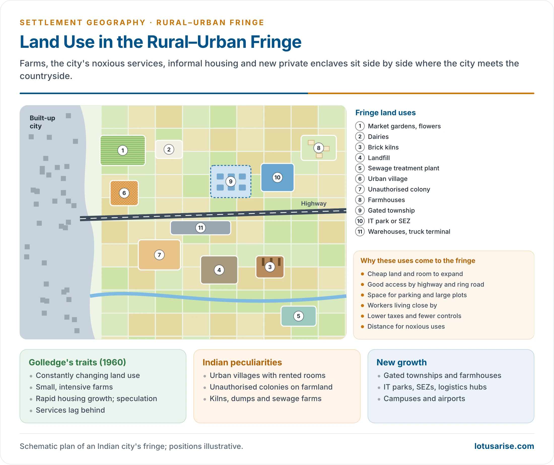
- The city’s noxious uses collect here: crematoria, sewage treatment plants, garbage dumps, brick kilns, polluting industries, industrial slums and haphazard markets.
- Urban shadow:
- Still rural in appearance, but under urban influence: city-dwellers own land, commute, and buy weekend homes and farmhouses.
- Land prices rise sharply in anticipation. Market gardening and dairying serve the city. This is where the fringe will expand next.
- Rural hinterland: beyond the shadow, with only weak urban influence.
- Wider functional limits:
- The daily urban system (commuter zone):
- The area from which people travel daily to the city for work, trade and services.
- It includes villages that supply the city’s daily needs of milk, vegetables and labour.
- The city region: the largest area of urban influence, defined by the city’s services, markets and newspapers, and delimited by the methods of the sphere of urban influence.
- Beyond the commuter zone: the urban field or city’s countryside, reaching up to about 100 miles, and the weekend and seasonal life space of second homes.
- The daily urban system (commuter zone):
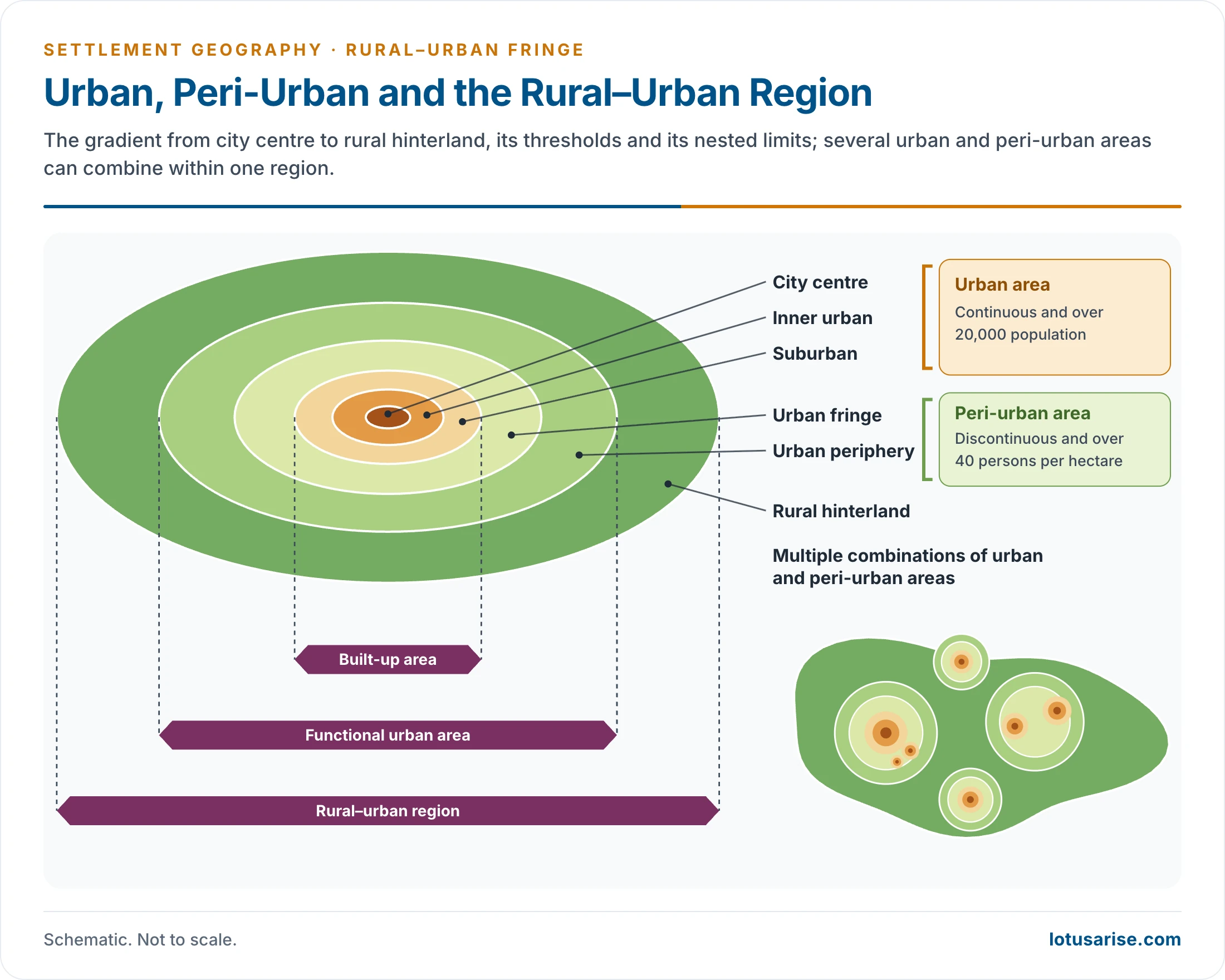
- Other ways of dividing the same gradient:
- Urban area (city centre, inner urban, suburban): continuous, with over 20,000 people.
- Peri-urban area (urban fringe, urban periphery): discontinuous, with over 40 persons per hectare.
- Nested limits: built-up area, functional urban area and rural–urban region. Several urban and peri-urban areas can combine within one region.
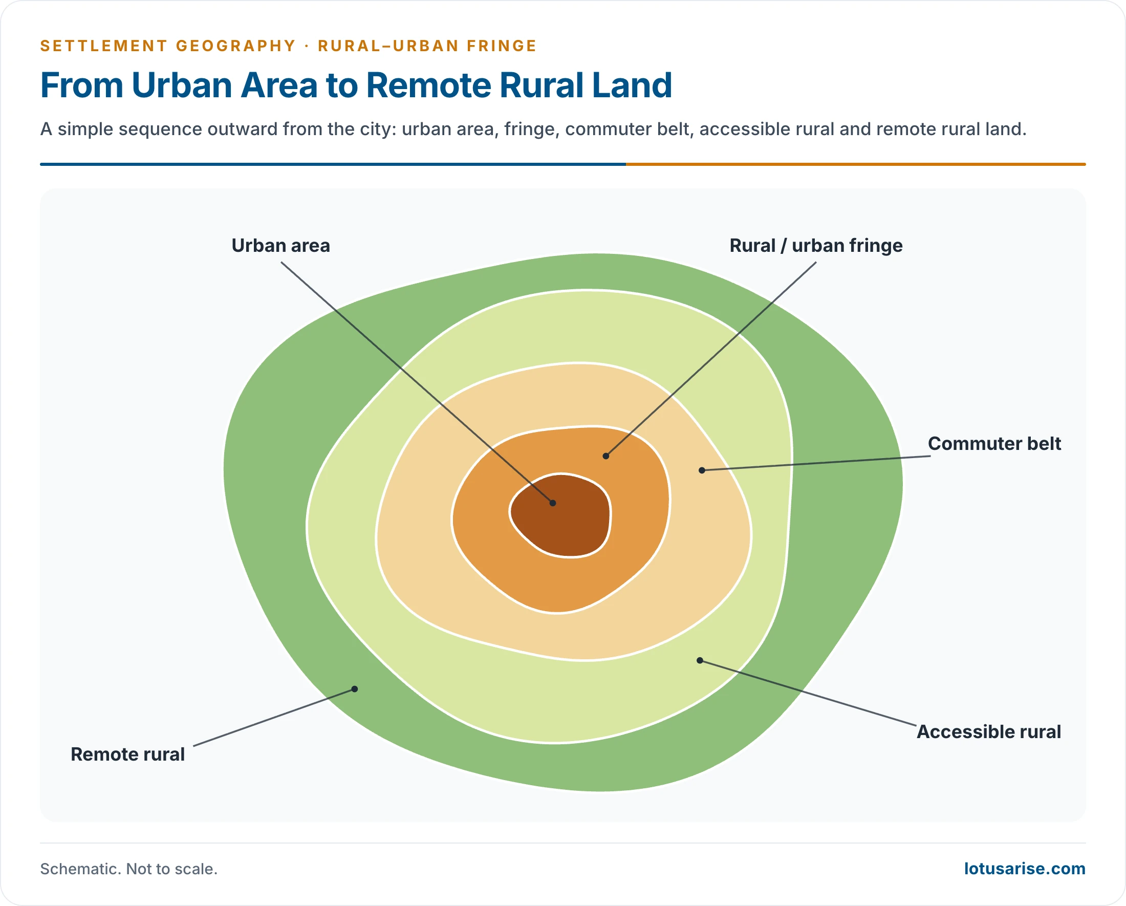
- A simple sequence: urban area, fringe, commuter belt, accessible rural and remote rural land.
Primary and Secondary Fringe
- Primary (inner) fringe, also called the area of convenience:
- It touches the city’s administrative limit and acquires urban facilities and activities fastest.
- Andrews called it the urban fringe. Myers and Beegle called it the “true fringe”, and M. M. P. Sinha the urban–suburban fringe.
- Secondary (outer) fringe, also called the slowly progressive zone:
- It lies beyond the primary fringe. It is mainly rural, changes slowly and has fewer urban functions.
| Zone | Land use | Population and occupation | Land value |
|---|---|---|---|
| Inner fringe | Mostly converted; colonies, industry, institutions | Dense, largely non-agricultural | High |
| Outer fringe | Mostly rural; scattered urban and noxious uses | Mixed; occupations changing | Rising |
| Urban shadow | Rural landscape; farmhouses, market gardens | Commuters, absentee owners | Speculative |
| Rural hinterland | Agriculture | Agricultural | Low |
Characteristics of the Fringe
Land-Use Characteristics
- Reginald Golledge (1960), studying Sydney’s fringe, listed its land-use traits:
- a constantly changing pattern of land use;
- small farms with intensive crop production;
- rapid residential expansion;
- inadequate services and public facilities;
- common speculative building.
- Later traits:
- Science and business parks, hypermarkets, retail parks, warehouses and logistics hubs.
- Airport expansion.
- Large land-hungry uses such as campuses, hospitals, golf courses and stadiums.
- In India the fringe shows:
- Market gardening of vegetables and flowers, and dairying for the city.
- Brick kilns, sand and stone quarries.
- Sewage farms, landfills and crematoria.
- Farmhouses of the rich.
- Unauthorised colonies on subdivided farmland.
- Urban villages with dense, unregulated rental housing.
- Warehouses, truck terminals and transport nagars along highways.
- Gated townships, IT parks and SEZs on acquired land.
Social and Economic Characteristics
- Segregation:
- Greenfield sites (undeveloped land outside the built-up area) are favoured by large firms for headquarters, offices, housing and industrial estates.
- Land uses and social groups are therefore separated.
- In India, gated enclaves sit beside villages and migrant settlements.
- Selective immigration:
- Middle-class families move out for space and a better environment. They are a small but economically powerful share of the city’s people.
- Dormitory settlements house middle-income commuters who work in the central city. Suburbanisation is most active at the municipal boundary.
- Poor migrants settle where rents are lowest.
- Commuting:
- Daily commuting between the fringe and the city causes peak-hour congestion. City governments must provide transport for peak loads.
- Demographic traits:
- Very high growth rates, often several times those of the city core, mainly from in-migration.
- A young, working-age and often male-heavy population, with a lower sex ratio near industrial areas.
- A large renting population in urban villages, where former farmers build rooms for migrant workers. Munirka in Delhi and Chakkarpur in Gurugram are examples.
- Occupational shift:
- Cultivators and farm labourers become construction workers, drivers, guards, traders and landlords.
- Some farmers grow rich on land sales. Others become landless.
- Social change:
- Rural and urban ways of life meet and clash. Joint families and caste bonds weaken.
- Crime and anomie may rise, as old norms break and new ones are not yet set.
Delimitation of the Fringe
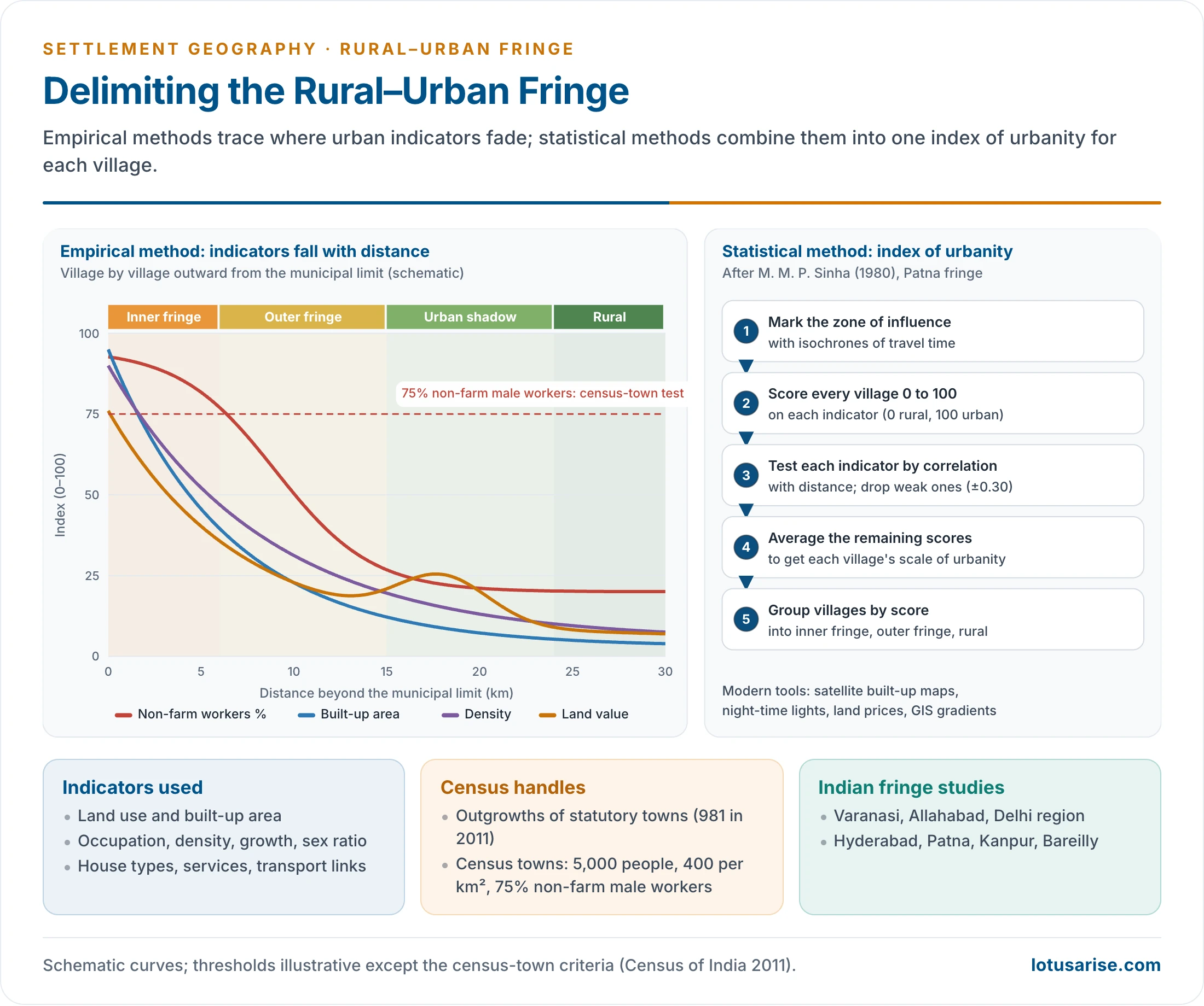
- Demarcating the fringe is difficult. It has no sharp edges, its width varies from city to city, and it moves outward as the city grows.
- Its outer limit is often placed some 10–20 km beyond the municipal limit of a large city, by direct observation, before refining it with data.
Empirical Methods
- The traditional method uses the continuous built-up area as the base and maps indicators outward from it.
- Contributors include T. Lynn Smith (1937), Andrews (1942), M. W. Rodehaver (1947), Myers and Beegle (1947), S. W. Blizzard and W. F. Anderson (1952), W. T. Martin (1957), D. Mukherjee (1963), Pryor (1968) and Oosthuizen (1969). In India, M. K. Srivastava and Ujagir Singh developed techniques.
- Indicators:
- Change in land use and in the built-up area.
- Occupational structure: the share of non-agricultural workers.
- Population density and decadal growth.
- House types and building materials.
- Distribution of industry and non-farm activities.
- The reach of essential services: piped water, electricity, bus or suburban rail service.
- The distribution of schools and colleges.
- Sex ratio: male-selective migration lowers it near the city.
- Census logic: a village with high population growth, falling dependence on agriculture and city transport links is moving towards urban status. The census town test is a population of 5,000, a density of 400 per km² and 75% of male main workers outside agriculture.
- An older working test for a fringe village, attributed to the Census, set five limits:
- density below 400 persons per km²;
- decadal population growth of 40% or more;
- sex ratio above 800 females per 1,000 males, because men move out for work;
- bus or local train service at the city’s outer limit;
- 50% or more of male workers in non-agricultural jobs.
- An older working test for a fringe village, attributed to the Census, set five limits:
Statistical Methods
- M. M. P. Sinha (1980), studying the Patna fringe, built a statistical index of urbanity:
- He first marked the city’s zone of influence with isochrones (lines of equal travel time).
- Each village was scored on several indicators on a scale from 0 (rural) to 100 (urban).
- Indicators were tested by correlation with distance. Those with weak correlation (between −0.30 and +0.30) were dropped.
- The mean score of the remaining indicators gave each village its scale of urbanity.
- Villages were then grouped into inner fringe, outer fringe and rural areas.
- Typical gradients: with distance from the city, population density falls, the share of non-farm workers falls, and the sex ratio rises (fewer male migrants).
- An Indian illustration: around Delhi, the ring of villages that became census towns between 2001 and 2011 traces the advancing inner fringe. Farther out, rising land prices and farmhouses along the highways mark the urban shadow.
- Modern methods use satellite imagery (built-up land and impervious surface), night-time lights, land-price data and GIS gradient analysis. These track the fringe year by year.
- Indian fringe studies:
- R. L. Singh on Varanasi; Ujagir Singh on Allahabad and the other KAVAL cities (Kanpur, Agra, Varanasi, Allahabad, Lucknow).
- Sudesh Nangia on the Delhi metropolitan region.
- K. N. Gopi on Hyderabad; M. M. P. Sinha on Patna.
- Harihar Singh on Kanpur; Hira Lal on Bareilly.
Growth of the Fringe
Stages of Growth
- Rural stage:
- Grain farming dominates. The village panchayat and village culture are intact, and urban influence is negligible.
- Agricultural land-use change:
- City demand transforms farming: market gardening, flowers and dairying replace grain.
- Occupational change:
- Cultivators and labourers take urban jobs in services and construction.
- Rising land prices draw farmland to city uses, and many farmers become landless.
- Urban land-use stage:
- Crematoria, sewage plants, the airport, bus depots, industrial units, townships and suburbs occupy the land.
- Slums and squatter settlements appear.
- Urban village stage:
- Almost the whole landscape is urban: colonies, hypermarkets, wholesale markets.
- Growth is haphazard, so redevelopment planning is needed. In the end, the urban village merges with the city.
Causes of Fringe Development
- The fringe is best seen as part of a rural–urban continuum rather than a sharp zone.
- Broad drivers:
- Population growth.
- Rising incomes.
- Transport and communication technology.
- Investment in new infrastructure.
- Internal (push) factors from the city:
- High land rents and the shortage of space.
- Environmental degradation and congestion.
- Housing shortage.
- Activities that cannot be carried on inside the city: landfills, polluting industry, warehousing.
- External (pull) factors at the fringe:
- Commuting facilities.
- Cheap land.
- Freedom from municipal taxes and controls.
- Open space and a cleaner environment.
Problems of the Fringe
- Unplanned, haphazard growth under a vacuum of governance:
- Revenue villages and panchayats lack the funds, staff and powers to plan.
- City authorities have no jurisdiction.
- Dumping ground of the city: garbage, sewage, crematoria and polluting industry, causing land and groundwater pollution.
- Slums, unauthorised colonies and overcrowded urban villages.
- Land speculation, concentration of land ownership, rapidly rising land values and disputes over acquisition.
- No public water supply or sewerage, unplanned streets, and poor public transport.
- Loss of farmland, wetlands and commons.
- Environmental stress: falling water tables from unregulated borewells (Gurugram and Bengaluru’s outskirts), encroachment on lakes and drains, quarrying of hills such as the Aravallis, and burning of waste at dumps.
- Mismatch of status and reality: many settlements meet the urban test but are still governed as villages. The 3,892 census towns of 2011 are an example. Metropolitan planning committees under the 74th Amendment have rarely worked.
- Social stress from the meeting of two cultures: crime and vandalism, broken families and shaken beliefs.
The Delhi Fringe: An Indian Case
- Gurugram:
- Private townships were built on farmland from the 1980s. Cyber City and the Delhi–Jaipur expressway corridor (NH-48) followed in the 2000s.
- Villages such as Sikanderpur and Chakkarpur were engulfed and became dense rental urban villages beside glass towers.
- Services lagged: piped water and sewerage came late, groundwater fell steeply, and the Aravalli hills and natural drains were built over.
- Noida and Greater Noida (from 1976) were planned by industrial development authorities on acquired land. Planned sectors stand beside old villages and farmland awaiting conversion.
- Within Delhi:
- Old village cores (lal dora land) were long exempt from building regulations, so they became high-density rental housing.
- Unauthorised colonies spread across farmland on the urban edge.
- Peri-urban belts run along the expressways towards Sonipat, Ghaziabad and Faridabad. Each mixes warehouses, farmhouses, brick kilns and new colonies. This is the classic outer fringe and urban shadow.
Urban Fringe in Developed and Developing Countries
| Aspect | Developed countries | Developing countries |
|---|---|---|
| Driving force | Choice: incomes, cars, preference for space | Necessity: migration, housing shortage, cheap land |
| Who moves out | Middle class and firms | Poor migrants as well as the middle class |
| Form | Planned low-density suburbs, retail and business parks | Mixed: gated enclaves, slums, urban villages, brick kilns |
| Services | Usually provided with growth | Lag far behind growth |
| Control | Green belts, zoning, growth boundaries | Weak; plans often bypassed |
| Examples | London’s green belt, US exurbs | Delhi–NCR, Bengaluru, Lagos, Jakarta |
- Problems in developed countries:
- Car dependence, long commutes and emissions.
- Loss of countryside and habitats.
- The high per-head cost of low-density infrastructure.
- Decline of the inner city as people and jobs move out.
- Problems in developing countries:
- Growth outruns planning and services.
- Informal housing and slums.
- Displacement of farmers with poor compensation.
- Polluting uses pushed onto the poor.
- Overlapping authorities.
- Prospects:
- The fringe offers room for expansion: housing, industry, logistics, institutions and new towns.
- Peri-urban agriculture supplies fresh food. Vegetables are grown on the Yamuna floodplain in Delhi, and the sewage-fed fisheries of the East Kolkata Wetlands treat the city’s waste water.
- Green infrastructure (wetlands, forests, green belts) protects the city’s ecology.
- Beneficial developments:
- Housing estates, science and business parks, hypermarkets and superstores, retail parks and out-of-town shopping centres.
- Office developments, hotels and conference centres, and airport expansion.
- All need large sites, cheap land, parking, good access and nearby workers, and they gain from a pleasant, less polluted setting.
- Indian examples:
- Delhi’s fringe in Gurugram, Noida, Ghaziabad and Faridabad.
- Bengaluru’s spread towards Whitefield, Electronic City and Devanahalli.
- Kolkata’s Rajarhat.
- Hyderabad’s Gachibowli and the airport corridor.
- Management:
- Green belts (London’s Metropolitan Green Belt from 1938) and urban growth boundaries.
- Regional planning: the NCR Planning Board (1985) and metropolitan planning committees under the 74th Amendment.
- Planned satellite towns.
- Land pooling in place of acquisition, as in Delhi’s land pooling policy and the Amaravati capital region. Owners give up part of their land for roads and services and keep a developed plot.
- The Shyama Prasad Mukherji Rurban Mission (2016), which develops clusters of villages with urban amenities while keeping their rural character.
Previous Year Questions
1992Major characteristics of the rural-urban fringe around metropolitan cities.1995Write short note: Land-use characteristics of the rural-urban fringe in India.1997Write short note: Rural- urban fringe.2007Write short note: Delineation of Urban Fringe.2009“There is no sharp divide where an urban-settlements stops and rural area begins.” Analyse the statement with reference to the sprawl of Indian cities.2018Peri-urbanization has created enormous environmental problems. Discuss their causes and consequences with reference to the National Capital Region (N.C.R) of India.2023Explain the problems and prospects of urban expansion in the context of urban fringe in developed and developing nations.2025How can rural-urban fringe be delineated? Explain with suitable examples from India.





sir one question is there…
discuss the parameter to understand the spatial distribution of indian agricultre and its regional desparity with suitable example
what should be the answer approach of the above question can you share ?
you can start by giving brief intro about agri situation in India with suitable data and drawing map
Parameters–
Environmental> climate (monsoon) , topography, Hydrology
Economical> employment and income varies between states and according to that farmers tend to apply suitable type of agri patter (North Eastern states>less developed>subsistence farming / North Western & southern states> developed states> Pb MH TN KT KR HR intensive farming)
Demography> over populated states (UP BH WB)>more land under farming
Administrative> Government Policies also affect the type of crop to be farmed (Rajsathan more millets / PB HR due to ground water level depletion govt is deviating to more water efficient crops )
Regional Disparity> will get covered in the above parameters if you explain it with suitable examples ( integrate regional disparity examples within the parameters) / or you can contrast agri between North v/s South dividing them in zones.
Thankyou
If any criticism please feel free. (so that I too get an opportunity tolearn)
what would be the criticism of above given question
what is delineation of urban fringe?
It means Method of Delimitation or Demarcation of Urban fringe.
thank u so much…
Sir how megalopolis and rural urban fringe overlap?
Is there a better explanation for statistical technique by M. M. P. Sinha of deliniation of rural urban fringe ?