

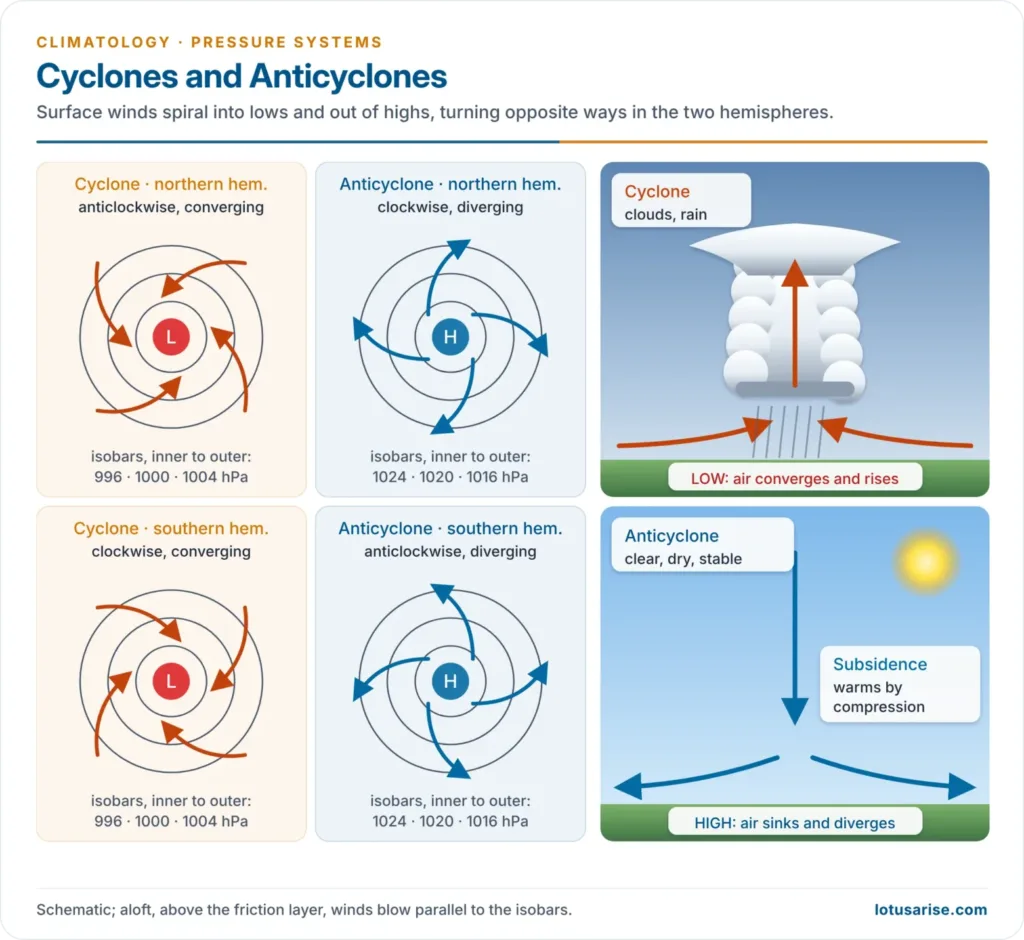
- A cyclone is a system of winds circling a low-pressure centre: air converges and rises, bringing clouds and rain. Winds turn anticlockwise in the northern hemisphere and clockwise in the southern.
- An anticyclone is the opposite: a high-pressure centre from which air sinks and diverges, bringing clear, dry, stable weather, with winds clockwise in the northern hemisphere.
- Both are secondary circulations of the atmosphere riding on the planetary pressure belts. Together with the oceans, they carry surplus heat and moisture from the tropics towards the poles.
Wind Patterns in Cyclones and Anticyclones
Why the Winds Circle
- Pressure gradient force: air starts moving from high towards low pressure.
- Coriolis force:
- The Earth’s rotation deflects moving air to the right in the northern hemisphere and to the left in the southern.
- The deflection is zero at the equator, strongest at the poles, and grows with wind speed. It changes only the direction of the wind, not its speed.
- Friction:
- In the lowest 1 km or so, friction slows the wind, so it crosses the isobars: inward into a low (convergence) and outward from a high (divergence).
- Higher up, friction vanishes and the wind blows parallel to the isobars (geostrophic wind).
Cyclone and Anticyclone Compared
| Feature | Cyclone (low) | Anticyclone (high) |
|---|---|---|
| Pressure | Lowest at centre | Highest at centre |
| Northern hemisphere | Anticlockwise | Clockwise |
| Southern hemisphere | Clockwise | Anticlockwise |
| Surface flow | Converges inward | Diverges outward |
| Vertical motion | Rising air | Sinking air |
| Isobars and winds | Closely spaced; strong winds | Widely spaced; light winds |
| Weather | Cloudy, rainy, stormy | Clear, dry, calm; fog or frost in winter |
| Indian example | Bay of Bengal cyclones, western disturbances | Winter high over north-west India |
Cyclones
- Cyclones are of two kinds:
| Basis | Tropical cyclone | Temperate cyclone |
|---|---|---|
| Latitude | 5°–30° | 35°–65° |
| Origin | Thermal: latent heat over warm sea | Meeting of cold and warm air masses on the polar front |
| Fronts | None | Warm and cold fronts |
| Size | 150–1,000 km | Up to 2,000–3,000 km |
| Winds | Very strong, often above 119 km/h | Moderate |
| Movement | East to west | West to east |
| Rain | Torrential, a few hours | Steady, over several days |
Tropical Cyclones
- Tropical cyclones are violent storms that form over warm tropical seas and strike coasts with destructive winds, torrential rain and storm surges.
- Conditions for formation:
- a warm sea surface (at least 26.5 °C) to a depth of about 50 m
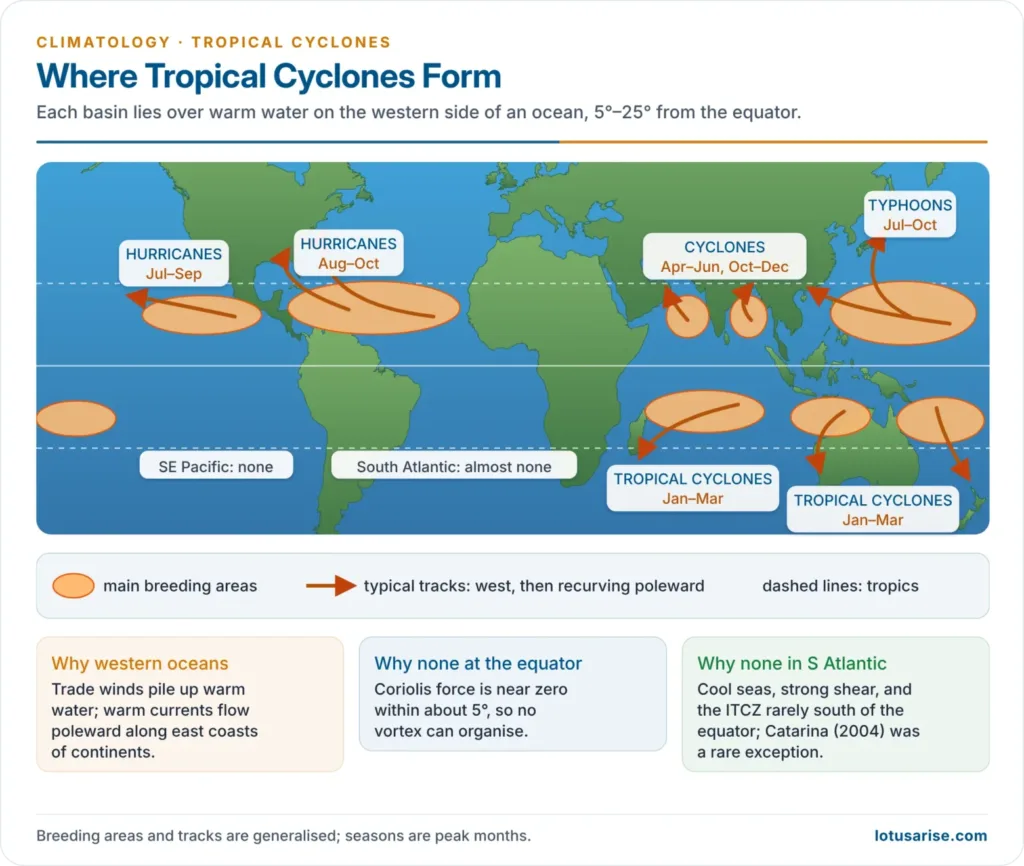
- enough Coriolis force, so none forms within about 5° of the equator
- a pre-existing low (an easterly wave or the monsoon trough)
- weak vertical wind shear
- a humid middle atmosphere
- upper-level divergence to remove the rising air
- Structure:
- A calm, warm, cloud-free eye (usually 30–65 km across) lies at the centre.
- Around it, an eyewall of cumulonimbus holds the strongest winds and rain.
- Outside are spiral rainbands.
- Regional names: hurricanes (Atlantic and north-east Pacific), typhoons (north-west Pacific), cyclones (Indian Ocean), willy-willies (old Australian name).
- Why they cluster in certain seas:
- They form in western parts of the oceans, where warm currents flow: the Caribbean and Gulf of Mexico, the Philippines and South China Sea, and the Bay of Bengal.
- Eastern parts are cooled by cold currents and upwelling.
- The South Atlantic is almost free of cyclones.
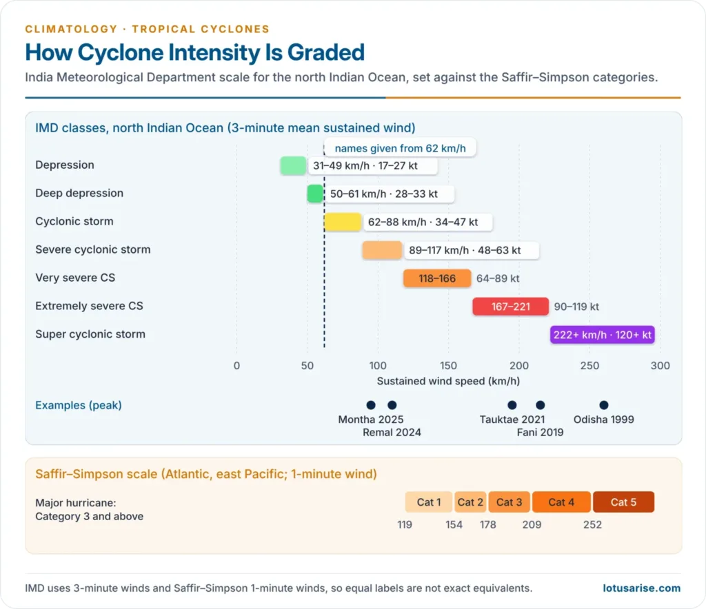
- IMD classification (3-minute sustained wind):
| Category | Wind (km/h) |
|---|---|
| Depression | 31–49 |
| Deep depression | 50–61 |
| Cyclonic storm | 62–88 |
| Severe cyclonic storm | 89–117 |
| Very severe cyclonic storm | 118–166 |
| Extremely severe cyclonic storm | 167–221 |
| Super cyclonic storm | 222 and above |
- Naming:
- IMD, New Delhi, one of the WMO’s six Regional Specialised Meteorological Centres, names north Indian Ocean cyclones for the 13 members of the WMO/ESCAP Panel on Tropical Cyclones.
- A list of 169 names was released in 2020. A name is given once a system reaches cyclonic-storm strength; names have at most eight letters, are used in sequence and are never repeated.
- Bay of Bengal versus Arabian Sea:
- The Bay gets about four times as many cyclones, and the deadliest surges, because its waters are warmer and its coasts are flat, low-lying deltas.
- The Arabian Sea saw a 52% rise in cyclones in 2001–2019 compared with 1982–2000, as it warmed.
- Seasons: cyclones peak in April–June and October–December. During the monsoon, strong wind shear keeps them rare.
- Storm surge: the abnormal rise of sea level driven ashore by the winds and low pressure of a cyclone, worst over the shallow, funnel-shaped head of the Bay. It causes most cyclone deaths: the 1999 Odisha super cyclone killed about 10,000 people.
- Changing behaviour: warmer seas are making rapid intensification (a jump of 55 km/h or more in 24 hours) more common, and the IPCC (2021) expects stronger, wetter cyclones with higher surges.
- Recent cyclones:
- Amphan (2020), a super cyclonic storm, hit West Bengal.
- Tauktae (2021) struck Gujarat, and Biparjoy (2023), the longest-lived Arabian Sea cyclone since 1977, struck Kachchh.
- Michaung (2023) flooded Chennai.
- Remal and Dana (2024) hit West Bengal and Odisha, and Montha (2025) hit Andhra Pradesh.
Temperate Cyclones
- Temperate (extratropical) cyclones form in middle latitudes (35°–65°) where cold polar and warm tropical air masses meet along the polar front.
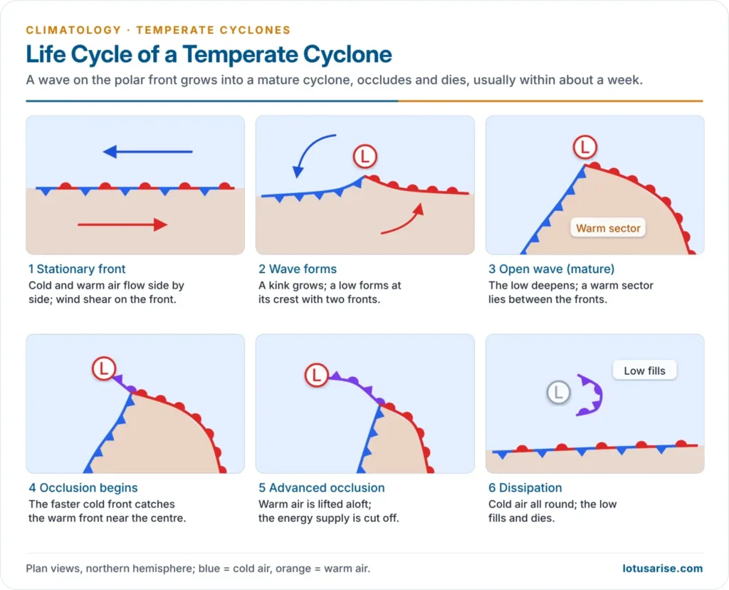
- Polar front theory: proposed by Jacob Bjerknes (1919) and the Bergen school led by his father Vilhelm Bjerknes. A wave on the front grows into a cyclone and passes through four stages:
- initial: a stationary front
- incipient: a wave forms
- mature: distinct warm and cold fronts enclose a warm sector
- occlusion: the faster cold front overtakes the warm front and the cyclone dies
- Characteristics:
- They have elliptical isobars and move west to east with the westerlies at 30–50 km/h.
- They last 5–7 days and come in families.
- Steady rain falls ahead of the warm front, and showers and thunderstorms along the cold front.
- Indian example: western disturbances from the Mediterranean bring winter rain to north-west India, which helps the rabi wheat crop, and snow to the Himalaya.
Cyclone Warnings in India
- IMD’s four-stage cyclone warning:
- pre-cyclone watch: 72 hours ahead
- cyclone alert (yellow): 48 hours
- cyclone warning (orange): 24 hours
- post-landfall outlook (red): 12 hours
- IMD’s general colour codes:
- green: no action
- yellow: be aware
- orange: be prepared
- red: take action
- Preparedness: Doppler radars, INSAT-3D/3DR, cyclone shelters under the National Cyclone Risk Mitigation Project, mass evacuation (over a million people before Fani, 2019) and mangrove belts have cut deaths sharply.
Anticyclones
- The term anticyclone was coined by Francis Galton (1863).
- Features:
- Subsiding air warms by compression and forms a subsidence inversion, so the air is stable and clouds and rain are suppressed.
- Pressure gradients and winds are weak compared with cyclones, and anticyclones are larger and slow-moving.
- Skies are clear, so the daily range of temperature is large.
Types of Anticyclones
| Type | Origin | Example |
|---|---|---|
| Subtropical (warm, dynamic) highs | Sinking air of the Hadley cell at about 30°; deep and semi-permanent | Azores, Pacific, Mascarene High |
| Polar continental (cold, thermal) highs | Radiational cooling of snow-covered land in winter; shallow (below about 2.5 km) | Siberian High, Canadian High |
| Travelling highs | Wedges of high pressure between moving temperate cyclones | Fair spells between depressions in Europe |
| Polar outbreak highs | Cold air surging equatorward behind a cyclone family | Cold waves in the USA and China |
| Blocking highs | Deep, stationary highs that block the westerly flow for days or weeks | Heat domes and cold spells |
Weather and Effects
- Winter:
- Cold anticyclones bring cold waves, frost, radiation fog and smog.
- Fog persisting under the inversion causes days of dull “anticyclonic gloom“.
- The Siberian High drives the cold, dry winter monsoon of East Asia.
- In north-west India, calm, clear winter anticyclonic weather brings cold waves, dense fog and trapped pollution over the Indo-Gangetic Plain.
- Summer:
- Stagnant warm highs bring heatwaves and drought.
- In the 2021 Pacific Northwest heat dome, Lytton, Canada, reached 49.6 °C.
- An upper-level anticyclone over north-west India and Pakistan is the usual setting of severe pre-monsoon heatwaves.
- Blocking:
- Blocking highs hold weather in place.
- In February 2018, the “Beast from the East” was a Scandinavian high that drove Siberian air into Britain.
- India and the monsoon:
- The Mascarene High in the south Indian Ocean pushes the south-west monsoon winds across the equator.
- The Tibetan anticyclone in the upper air feeds the Tropical Easterly Jet.
- Both shape the Indian monsoon.
Previous Year Questions
2023Explain the characteristics and weather conditions associated with ‘anticyclones’, giving suitable examples.2022 · GS Paper IDiscuss the meaning of colour-coded weather warnings for cyclone prone areas given by India Meteorological Department.2014 · GS Paper ITropical cyclones are largely confined to the South China Sea, the Bay of Bengal and the Gulf of Mexico. Why?


Thank you
One stop solution ,,,,keep it up brooo