

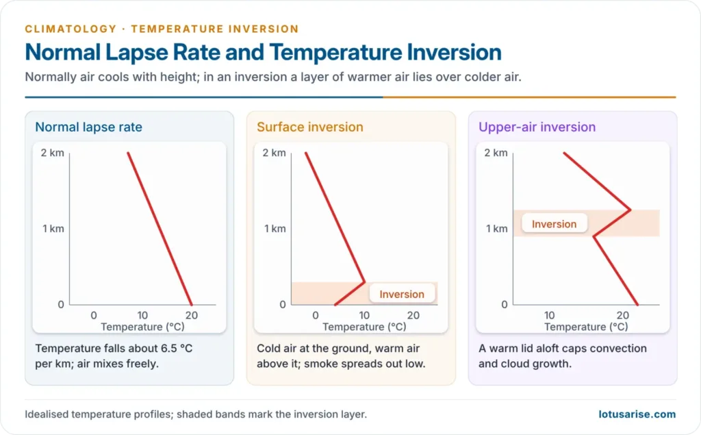
- In the troposphere, temperature normally falls with height at an average normal lapse rate of 6.5 °C per km (about 1 °C per 165 m), because the air is heated from the ground below.
- A temperature inversion (thermal inversion) is a layer in which this is reversed and temperature rises with height: warm air lies over cold air. It is also called a negative lapse rate.
- The cold, dense air below the warm layer cannot rise through it, so an inversion is the most stable state of the atmosphere. It acts as a lid on convection, cloud growth and the dispersal of pollutants.
- Most inversions are shallow and short-lived (a night, a few days), but some are semi-permanent: the polar winter inversion and the trade-wind inversion over the subtropical oceans.
Types of Temperature Inversion
- Inversions are grouped by where they form and what causes them:
- Surface (ground) inversions: radiation inversion, valley (air-drainage) inversion, advection inversion
- Upper-air inversions: subsidence (including the trade-wind) inversion, turbulence and convective inversion
- Frontal inversion
Radiation (Ground) Inversion
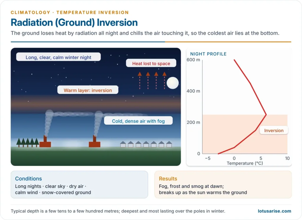
- Mechanism: on long, clear nights the ground loses heat rapidly by terrestrial radiation and chills the air touching it by conduction. The coldest air lies at the surface, under warmer air above.
- The inversion is usually a few tens to a few hundred metres deep and breaks up after sunrise as the ground warms.
- Ideal conditions:
- long winter nights, so outgoing radiation far exceeds incoming
- clear skies, so radiation escapes unhindered
- dry air, which absorbs little of that radiation
- calm air, so there is no mixing
- a snow-covered surface, which reflects sunlight by day and insulates the ground’s heat by night
- Occurrence:
- over the polar regions for much of the year, especially in winter, where it is deepest and most persistent
- over the continents in winter in middle latitudes
- over the oceans in summer, when the sea is cooler than the air above
- If the surface air cools below its dew point, fog or frost forms; smoke and dust trapped under the inversion turn the fog into smog.
Valley (Air-Drainage) Inversion
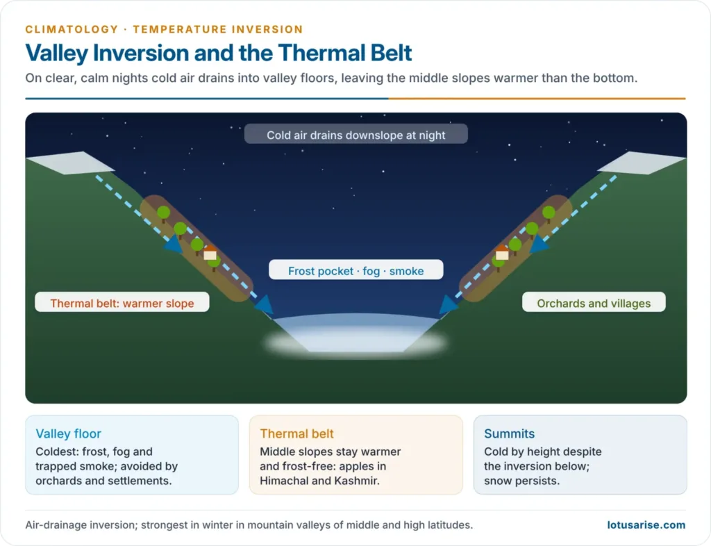
- Mechanism: on clear, calm nights, air on the hill slopes cools by radiation, becomes dense and drains downhill (a mountain or katabatic breeze) into the valley floor. The valley fills with cold air while the slopes above stay warmer.
- Effects:
- The valley bottom becomes a frost pocket with fog and smoke; the warmer middle slopes form a frost-free thermal belt.
- Orchards, plantations and villages therefore occupy slopes, not valley floors: the vineyards of the Alps, coffee in Brazil and Colombia, orange groves in California, and apple orchards in Himachal Pradesh and Kashmir.
- In the Kashmir Valley, winter inversions trap smoke from heating fuel over Srinagar, and the valley floor sees dense fog in Chillai Kalan (late December to January).
Advection Inversion
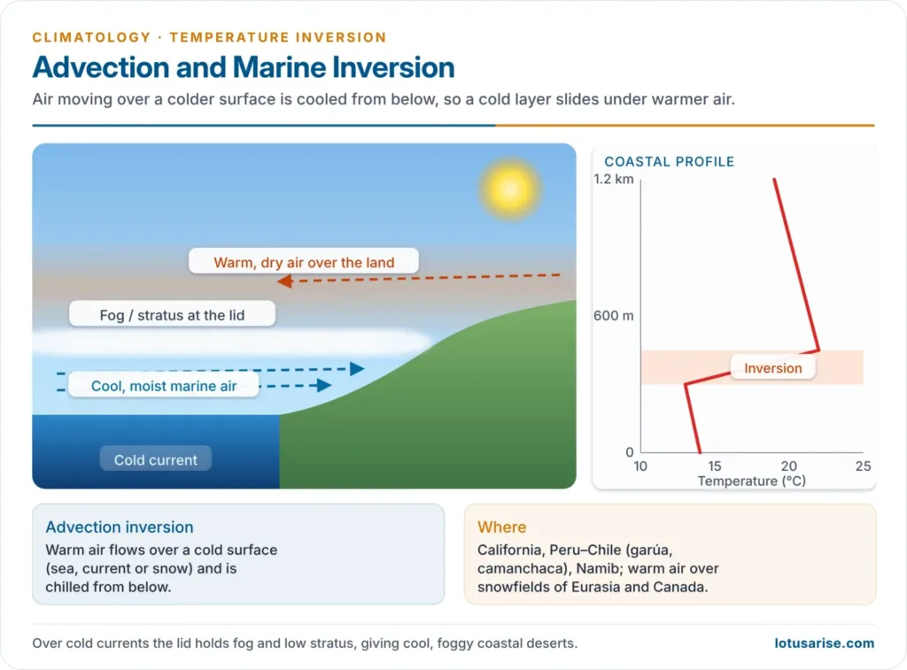
- Mechanism: warm air moves horizontally over a cold surface (cold sea, cold current, snow cover) and is chilled from below, so a cold layer forms under warm air.
- Warm, moist maritime air over the snow-covered lowlands of northern Eurasia and Canada in winter
- Marine inversion: in spring and summer, cool, moist sea air flows inland beneath warmer, drier air over the land (the coasts of California and Chile–Peru)
- Advection inversions over cold currents bring the coastal fogs of the Atacama (camanchaca), Peru (garúa) and Namib deserts, which have almost no rain.
Subsidence Inversion
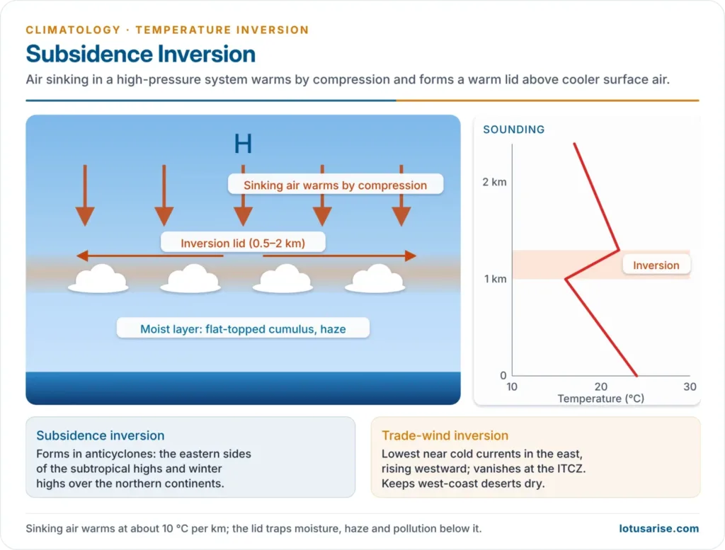
- Mechanism: in a high-pressure system, a deep layer of air sinks and is compressed, warming at the dry adiabatic rate (about 10 °C per km). It spreads out above a lower layer that is not sinking, which stays cooler, so an inversion forms well above the ground, usually 0.5–2 km up.
- Occurrence: over the subtropical highs, especially their eastern sides (the Azores and Pacific highs), and over the northern continents under the winter anticyclones.
- On some nights, a high-pressure area holds two inversions: a radiation inversion at the ground and a subsidence inversion aloft.
- Trade-wind inversion:
- a subsidence inversion capping the trade winds over the eastern subtropical oceans, a few hundred to about a thousand metres thick
- lowest and strongest on the eastern sides of the oceans, near the cold currents, and rising and weakening westward and towards the equator, where it vanishes at the ITCZ
- Below it the air is moist and holds shallow cumulus; above it the air is dry. By capping cloud growth, it keeps the trade-wind belt and the west-coast deserts (Sahara, Atacama, Namib, Australia) dry.
- Los Angeles is the classic case: the Pacific High’s subsidence inversion, the cold California Current and the encircling mountains trap vehicle exhaust as photochemical smog.
Turbulence and Convective Inversion
- Mechanism: turbulent mixing (by friction or convection) is limited to a certain depth. Air carried up within the mixed layer cools adiabatically and air brought down warms, so the top of the mixed layer ends up colder than the undisturbed air above it, forming an inversion.
- Signs: stratus or stratocumulus decks and haze lines of smoke spreading out beneath it; at great heights, the flat anvil of a cumulonimbus marks a similar lid at the tropopause.
Frontal Inversion
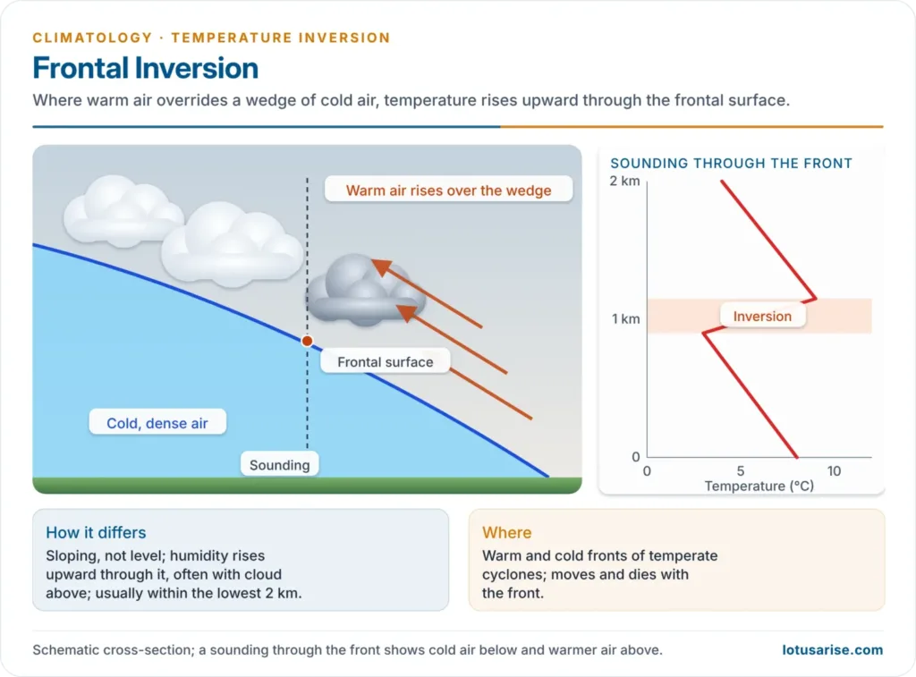
- Mechanism: where a warm air mass meets a cold one at a front, as in temperate cyclones, the lighter warm air overrides the cold wedge, so warm air lies above cold along the frontal surface.
- How it differs from other inversions:
- The inversion layer is sloping, not horizontal, because the front slopes.
- Humidity increases upward through it, and cloud often lies just above it; in other inversions humidity falls with height.
- It is usually confined to the lowest 2 km, and the lapse rate in the frontal zone is often just very low rather than truly reversed.
- It is transient, moving and dissolving with the front.
| Type | Height | Cause | Typical setting |
|---|---|---|---|
| Radiation | Surface, up to a few hundred m | Night-time radiative cooling of the ground | Clear, calm winter nights; polar winter |
| Valley (air drainage) | Valley floor | Cold air draining downslope | Mountain valleys; Kashmir, Alpine valleys |
| Advection | Low | Warm air over cold sea, current or snow | Cold-current coasts; snowfields |
| Subsidence | 0.5–2 km aloft | Sinking, compression-warmed air | Subtropical highs; trade winds; winter anticyclones |
| Turbulence / convective | Top of mixed layer | Limited vertical mixing | Haze lines; stratocumulus decks |
| Frontal | Along a sloping front | Warm air overriding cold | Temperate cyclones |
Significance of Temperature Inversion
- Weather:
- Fog, frost and dew form under surface inversions; stratus forms beneath the lid.
- Convective clouds cannot grow through an inversion, so it brings stable, dry weather and suppresses showers (the trade-wind belt, winter anticyclones).
- The inversion narrows the diurnal range of temperature, because night cooling is confined to a thin layer.
- Where a warm layer aloft overlies sub-freezing surface air, as ahead of warm fronts, snow melts into rain that freezes on contact with the ground (freezing rain).
- Air pollution:
- Pollutants rising from chimneys and vehicles spread out under the base of the inversion instead of dispersing upward.
- London (5–9 December 1952): an anticyclone and inversion trapped coal smoke; about 4,000 people died within days, and later estimates put the toll at 10,000–12,000. It led to the Clean Air Act 1956.
- Indo-Gangetic Plain: in winter, calm anticyclonic weather, long clear nights and the Himalayan barrier produce strong night-time inversions and a very shallow mixing layer. Smoke from stubble burning, vehicles, brick kilns, industry and biomass fuel is trapped, so Delhi and the plain record their worst air quality from November to January.
- Agriculture and settlement:
- Frost in valley bottoms damages wheat, mustard, potato, gram and vegetables in north India; in the hill states, frost pockets limit orchards to the slopes.
- Settlements, plantations and hotels in mountain regions favour the upper slopes over the cold, foggy valley floors.
- Transport: fog under inversions cuts visibility to under 1 km, delaying flights and trains and causing road accidents across north India every winter.
Previous Year Questions
2026Why is it difficult to improve the quality of air during the winter season in the Gangetic plain? Critically evaluate with suitable examples.2023How does inversion of temperature occur? Explain its significance on local weather with suitable examples.2010Write short note on Inversion of temperature.1995Write short note: Inversion of temperature.





Respected sir! Please available all geography notes in pdf form. This is very humble request to you sir! Thank you.
Amit Ji, my first priority is to write all notes on the website after that I will start the compilation of notes in pdf format and it will take lots of time for a single person, I would like to suggest to all my UPSC aspirants that please read articles again and again and make your own short notes for the final exam.
Sir please ,upload the remaining notes of topics . Your notes are really helpful.
Thanks a lot
I am working on the same. keep Reading
Will you be able to complete notes by MARCH /APRIL ??
Sorry, I will complete it before Mains 2021.
Thank you so much sir ! Looking forward .
I THINK YOU ARE GENEOUS AND I WANT TO WORK WITH YOU .
I AM A GEOGRAPHY TEACHER AND ALSO MEDITATION MENTOR . IN FUTURE IF YOU AGREE THEN WORK TOGETHER.
YOU ARE DOING VERY HARD WORK AND I APPRECIATE YOUR WORK .
Thank you.
very helpful
very helpful sir
Sir this website is very useful and productive. I visit Daily for a particular topic thanks for the efforts cause your articles covers mains also 🙏🙏