

- Three major river systems and their tributaries built the Northern Plains: the Indus, Ganga and Brahmaputra. The tract is also known as the Great Plain of North India.
- Size:
- Area: the round figure usually quoted is about 7 lakh sq km, and the fuller count for the whole tract is 7.8 lakh sq km.
- Length: about 2,400 km within India, out of about 3,200 km from the Indus mouth to the Ganga mouth.
- Breadth: the usual range is 240–320 km, while the ground width runs from 60–100 km in Assam to about 500 km at the western end.
- It is a densely populated physiographic division. Fertile soil, enough water and a kindly climate make it one of India’s most productive farming tracts.
- Limits:
- North: the Shiwaliks, with the Himalayan Frontal Fault (HFF), also called the Main Frontal Thrust, running between hills and plain.
- South: an uneven, wavering line that follows the northern rim of Peninsular India.
- East: the Purvanchal hills.
- Four regional units make up the whole: the Rajasthan, Punjab-Haryana, Ganga and Brahmaputra Plains.
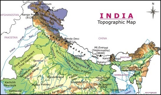
- On this map, “Nanga Prabat” is Nanga Parbat and “Sundar Bans” is the Sundarbans. Current heights are Kanchenjunga 8,586 m, Nanda Devi 7,816 m and Mount Everest 8,848.86 m.
Regional Plains and Doabs
What a Doab Is
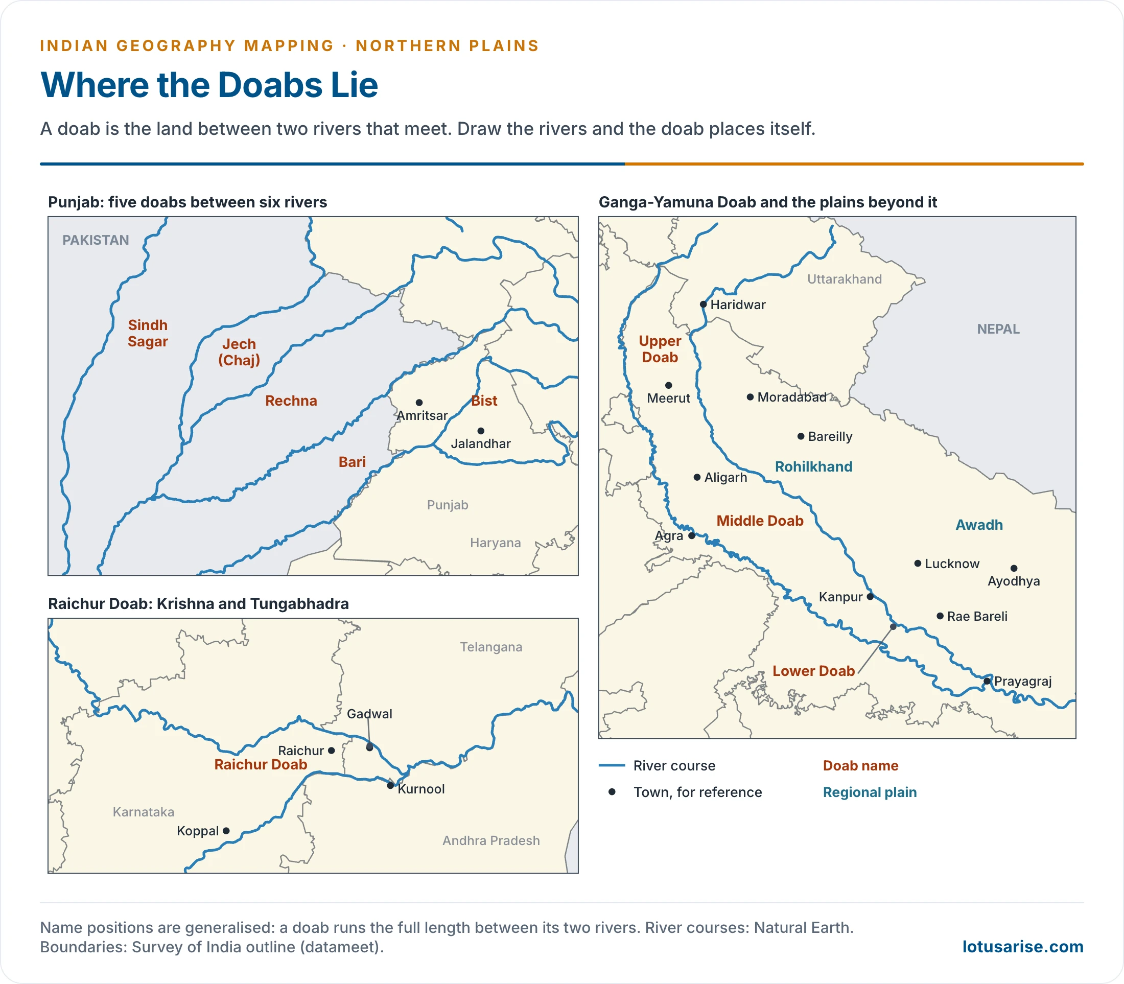
- Doab joins do (“two”) and ab (“water” or “river”). It means a region lying between two rivers and reaching to the point where they meet.
- Most of the doabs below carry names built from the first letters of their two rivers: Bist from Beas and Sutlej, Bari from Beas and Ravi, Rechna from Ravi and Chenab, and Jech from Jhelum and Chenab.
Punjab Plains
- This is the western alluvial part of the plain, with the arid Rajasthan Plain beyond it to the south-west.
- The Delhi-Aravalli ridge marks it off from the Ganga plains in the east.
- The Indus and its tributaries, the Jhelum, Chenab, Ravi, Beas and Sutlej (Satluj), laid it down.
- A major portion now lies in Pakistan.
- It breaks into five doabs, which long deposition has fused into one nearly uniform surface.
Punjab Doabs
| Doab | Between | Position | Remarks |
|---|---|---|---|
| Sindh Sagar | Indus and Jhelum | Pakistan | Below their meeting, the Jhelum-Chenab forms its eastern side |
| Jech (Chaj) | Jhelum and Chenab | Pakistan | A small portion lies in Majha |
| Rechna (Rachna) | Chenab and Ravi | Pakistan | A considerable portion lies in Majha |
| Bari | Ravi and Beas | India and Pakistan | A considerable portion lies in Majha |
| Bist (Doaba) | Beas and Sutlej | India | Also Bist-Jalandhar Doab |
- Majha (“middle”) is the central Punjab tract that runs north from the Beas. It was split between India and Pakistan in 1947: Amritsar, Tarn Taran, Gurdaspur and Pathankot lie in India, and Lahore in Pakistan.
- Doaba covers the Jalandhar, Hoshiarpur, Kapurthala and Nawanshahr districts. The Bist Doab Canal, part of the Bhakra-Nangal Project, irrigates about 4 lakh hectares in Jalandhar and Hoshiarpur.
Ganga Plains
- West to east, they run from the Yamuna catchment to the Bangladesh border.
- States: the core lies in Uttar Pradesh, Bihar and West Bengal. Taken up to the Yamuna catchment, the plain also covers Haryana’s eastern side and Delhi, the southern foot of Uttarakhand and part of Jharkhand.
- Lower Ganga plain: a block of Peninsular India sagged by downwarping in the gap between the Rajmahal Hills and the Meghalaya Plateau. Sediment from the Ganga and Brahmaputra then filled the hollow.
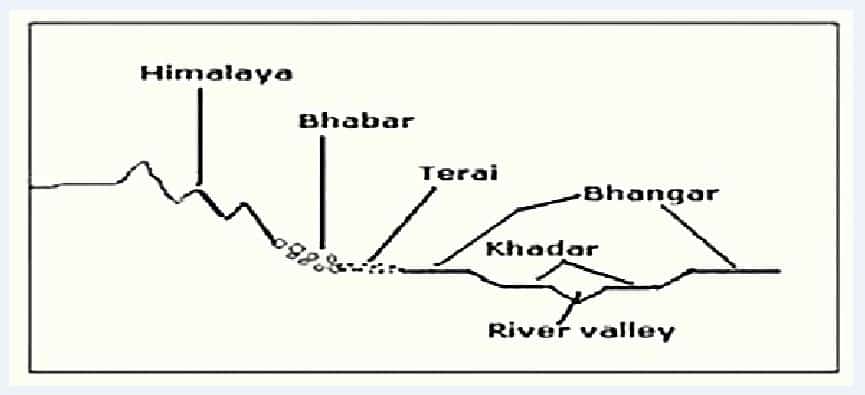
- Relief is varied by Bhabar, Terai (Tarai), Bhangar and Khadar, along with levees and abandoned courses.
- A north-south traverse crosses them in turn: the porous pebble strip of the bhabar, the marshy terai, the older-alluvium terraces of the bhangar, and the khadar floodplain renewed by each flood.
- Nearly all the rivers here wander from their courses, so floods come often.
- The Kosi is the extreme example, long called the “Sorrow of Bihar”. It flowed near Purnea in 1736 and now runs about 110 km west of it, and in August 2008 it broke its embankment at Kusaha in Nepal.
- The Ganga-Brahmaputra delta ranks as the largest in the world.
- Much of its seaward side carries tidal forest, the Sundarbans (Sunderbans), the world’s largest mangrove swamp. The name comes from the sundri (sundari), a tree at home in marshland.
- The forest shelters the Royal Bengal tiger and crocodiles.
Ganga Doab
- The Ganga Doab, usually called the Ganga-Yamuna Doab, is the largest doab of India. Elevation, rainfall and the character of the older floodplains divide it into three.
| Section | State or Union Territory | Districts |
|---|---|---|
| Upper Doab | Uttarakhand | Dehradun, Haridwar |
| Uttar Pradesh | Saharanpur, Shamli, Muzaffarnagar, Baghpat, Meerut, Ghaziabad, Hapur, Gautam Buddh Nagar, Bulandshahr | |
| Delhi | Delhi | |
| Central or Middle Doab | Uttar Pradesh | Etah, Kasganj, Aligarh, Agra, Hathras, Firozabad, Farrukhabad, Kannauj, Mainpuri, Etawah, Auraiya, Mathura |
| Lower Doab | Uttar Pradesh | Kanpur, Fatehpur, Kaushambi, Prayagraj (Allahabad) |
- Mathura belongs to Braj, on the trans-Yamuna side.
- Lists differ at the margin: Farrukhabad, Kannauj, Etawah and Auraiya are also set in the Lower Doab.
- The Upper Doab runs from Haridwar down to about Aligarh. The Eastern Yamuna and Upper Ganga canals water it, it receives more rain than the other two, and it ranks among the most fertile parts of the plain.
- The Lower Doab is a flat tract that ends at the Ganga-Yamuna confluence at Prayagraj.
- Wheat dominates the doab’s farming, along with rice, maize, sugarcane, bajra, pulses and fodder.
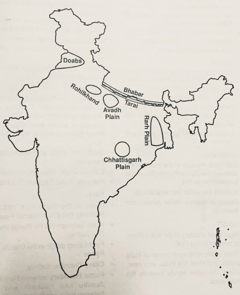
Rohilkhand Plain
- A low-lying alluvial region of north-western Uttar Pradesh, on the upper Ganga alluvial plain, reaching from the foot of the Himalaya to the Ganga.
- The Ganga bounds it on the west and the Awadh (Avadh) Plain on the east, with Bareilly and Moradabad as its centres.
- Size: about 25,000 sq km, with older estimates up to 35,000 sq km.
- Name: after the Rohillas, Pathan settlers of Pashtun descent drawn from several tribes, the Yusufzai among them. They settled here under the Mughals, in what was then the Katehar country.
- The Sanskrit epics, the Mahabharata among them, knew the region as Madhyadesh and Panchala.
- Along with the upper Ganga-Yamuna Doab it is a core sugarcane area of Uttar Pradesh.
Awadh Plain
- The central part of Uttar Pradesh, with Purvanchal to its east and Rohilkhand to its west. Purvanchal here means the State’s eastern region, and has no link with the north-eastern hills of the same name.
- Its old title was the granary of India, and its cuisine and culture have a character of their own.
- Cities: Lucknow, Rae Bareli and Ayodhya (Faizabad). Kanpur stands at its south-western edge, on the Ganga’s right bank, within the Lower Doab.
- The Ghaghara is its main river. It meanders and often changes course, its khadar reaches 55 km wide in places, and the plain lives with a constant threat of floods.
Rarh Plain
- It lies between the Chota Nagpur Plateau in the west and the main flow of the Ganga in the east. That flow has kept changing its line.
- More exactly, it takes in the lower Gangetic plains south of the Ganga and west of its Bhagirathi-Hooghly distributary.
- It is made of old alluvial deposits, with lateritic soil and low badlands called khoai. Soil erosion is its main land problem.
- Elevation: 75–150 m on the higher side next to the plateau. The plain proper ends near the 50 m contour.
- The Damodar is the main river, with the Ajay, Mayurakshi and Kangsabati (Kasai).
- It is a highly industrialised region, centred on the Asansol-Durgapur belt.
- It was once infamous for disastrous floods, which earned the Damodar the name “Sorrow of Bengal”. The Damodar Valley Corporation, set up on 7 July 1948, has reduced them.
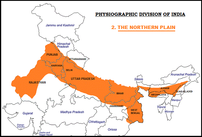
- This map follows the older political layout: “Orissa” is Odisha, and Jammu and Kashmir is now two Union Territories, Jammu and Kashmir and Ladakh. Dadra and Nagar Haveli and Daman and Diu are now one Union Territory.
Plains and Doabs of the Peninsula
- These three names sit on the same atlas list, but they lie south of the Great Plain, on the Peninsular Plateau. Peninsular rivers shaped them, and Himalayan alluvium played no part.
Malwa Doab
- Rivers crossing the Malwa region, in western Madhya Pradesh and south-eastern Rajasthan, also enclose doab tracts, listed as the Upper and Lower Malwa doabs.
- Malwa in this sense is the lava plateau, drained in the north by the Chambal and its tributaries. The Malwa plain of Punjab, south of the Sutlej, is a separate tract with the same name.
Chhattisgarh Plain
- The one true plain of the Peninsular plateau: a saucer-shaped hollow through which the upper Mahanadi flows with its tributaries, the Seonath, Hasdeo and Mand among them.
- The Maikala Range and the Odisha hills hold the basin between them, and it is about 160 km wide.
- Bounded by:
- North: Chota Nagpur plateau
- North-east: Raigarh hills
- South-east: Raipur Upland
- South: Bastar plateau
- West: Maikala Range
- Name: the Haihaya (Haihayavanshi) Rajputs of Ratanpur once ruled it, and tradition derives the name from their thirty-six forts (chhattis garh).
- Rocks: nearly horizontal beds of limestone and shale, of Cuddapah age in the classical scheme and now grouped as the Proterozoic Chhattisgarh Supergroup.
- Elevation: about 330 m on the west side, falling to about 250 m on the east.
- Farming: its paddy earned it the title “rice bowl of India”, or of central India in some usage. The Mahanadi basin holds the best soils in this otherwise modest plateau belt.
- Minerals: extensive coal, as at Korba, and substantial iron ore, as at Dalli-Rajhara, along with bauxite, manganese and commercial clays, have helped it grow.
- Towns:
- Chief commercial centres: Bhilai, Bilaspur, Raipur, Raigarh and Durg.
- Developing urban centres: Korba and Rajnandgaon.
Raichur Doab
- The triangular wedge between the Krishna and its tributary, the Tungabhadra, named after the town of Raichur.
- States: Karnataka and Telangana. It includes Raichur and Koppal districts in Karnataka and Jogulamba Gadwal district in Telangana.
- The eastern tip, the Gadwal-Alampur tract, formed part of Andhra Pradesh until 2014, when it passed to Telangana.
- River sediment makes it fertile, and it holds the Hutti gold field in Raichur district.
- It was the prize of a long contest between Vijayanagara and the Bahmani kingdom, with Krishnadevaraya’s victory at the Battle of Raichur (1520) as its best-known event.
Previous Year Questions
2001Discuss the relief features of Indian Northern Plains.1995Examine the origin and characteristics of the soils of the North Indian Plain.1993Delineate the flood-prone areas of India by drawing a sketch map in the answer book and discuss the causes and consequences of floods in the North Indian plains.- No direct PYQ has been asked on the individual doabs, or on the Rohilkhand, Awadh, Rarh or Chhattisgarh Plains, yet.
Beautifully explained.