

- A beach is a landform along a body of water, made of loose particles such as sand and shingle.
- India’s beaches line both the eastern and western shores of the Peninsula and the two island groups. The coastline was long given as 7,517 km (7,516.6 km), and was re-assessed in 2025 to 11,098.81 km, with no change in the land itself.
- Why they matter:
- They offer a vantage point for watching the sun set over the sea, and draw visitors to their golden sands.
- They guard a rich cultural heritage, with temples, memorials and monuments along the shore.
- Several are sites of adventure sports: skiing, scuba diving, parasailing and windsurfing.
- The coast draws migratory birds and aquatic life to its shores.
- Sandy beaches, coves, spits, lagoons and sea cliffs form the seascape side of tourism. It thrives on shores with mild waves and safe currents.
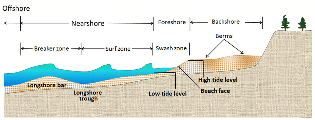
- Zones of a beach, from land to sea:
- Backshore: above normal high tide, carrying the berms.
- Foreshore: between high tide and low tide levels, with the beach face and swash zone.
- Nearshore: the surf and breaker zones, with the longshore trough and longshore bar.
- Offshore: beyond the breakers.
Blue Flag Beaches
- Blue Flag is an international eco-label of the Foundation for Environmental Education, Denmark, renewed every year.
- India’s count reached about 18 in the 2025–26 season, after the five Maharashtra beaches of October 2025.
| Season | Beaches | State or Union Territory |
|---|---|---|
| October 2020 | Shivrajpur | Gujarat |
| Ghoghla | Dadra and Nagar Haveli and Daman and Diu | |
| Kasarkod, Padubidri | Karnataka | |
| Kappad | Keralam (Kerala) | |
| Rushikonda | Andhra Pradesh | |
| Golden Beach (Puri) | Odisha | |
| Radhanagar | Andaman and Nicobar Islands | |
| 2021 | Kovalam | Tamil Nadu |
| Eden | Puducherry | |
| 2022 | Thundi (Minicoy), Kadmat | Lakshadweep |
| Later | Chal | Keralam |
| October 2025 | Srivardhan (Shrivardhan), Nagaon, Parnaka, Guhagar, Ladghar | Maharashtra |
West Coast Beaches in India
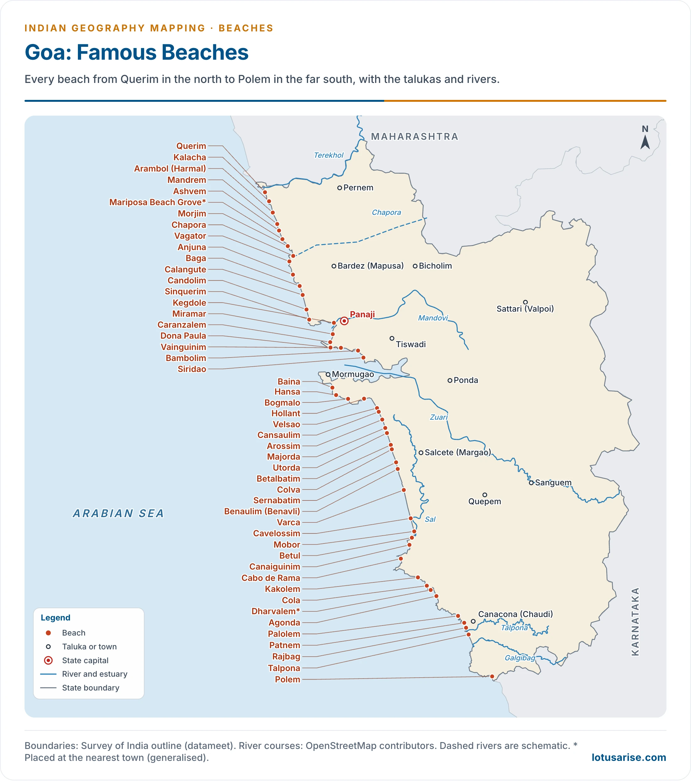
Gujarat
- Kachchh coast: Mandavi, Pingleshwar Mahadev.
- Saurashtra coast: Shivrajpur, Dwarka, Beyt Dwarka, Okha Madhi, Porbandar, Madhavpur, Chorwad, Ahmedpur Mandvi, Somnath, Veraval Chowpati, Sarkheswar.
- South Gujarat: Dumas, Hajira, Suvali, Ubhrat (Umbharat), Danti, Dandi, Tithal, Nargol, Umbergaon, Kotna, Dabhari.
- Dadra and Nagar Haveli and Daman and Diu: Diu, Ghoghla, Nagoa and Jampore.
- Chorwad and Ahmedpur Mandvi are known for their long stretches of golden sand. Dandi is the end point of Mahatma Gandhi’s Salt March of 1930.
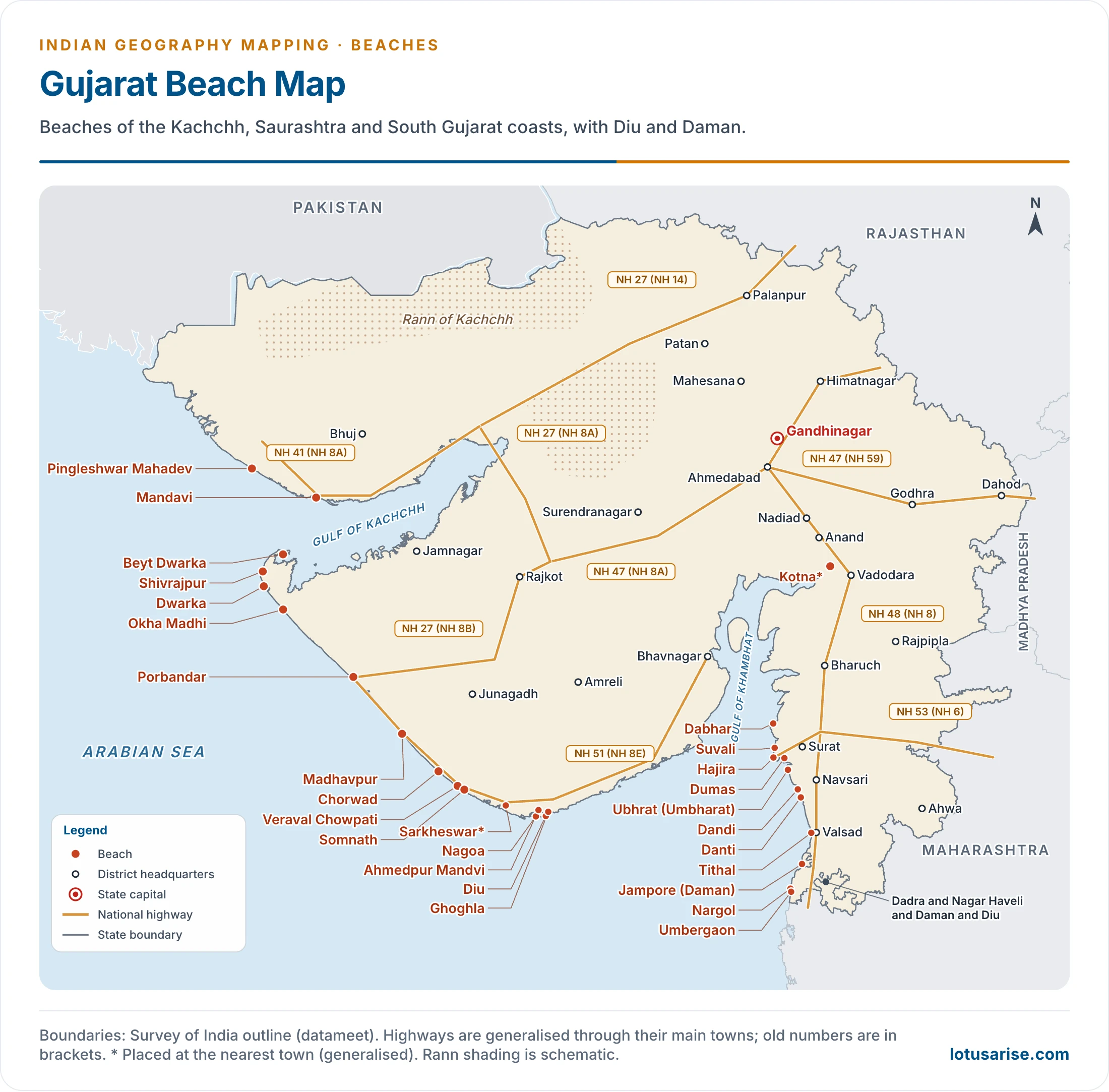
Maharashtra
- Mumbai and Palghar: Juhu, Aksa, Versova, Marve, Gorai, Manori, Shivaji Park, Vasai (Bassein), Kalamb, Kelwa, Dahanu, Bordi, Parnaka.
- Raigad: Alibaug, Mandwa, Kihim, Awas, Rewas, Nagaon, Revdanda, Kashid, Murud, Agardanda, Diveagar, Srivardhan, Harihareshwar, Varsoli.
- Ratnagiri: Harnai, Kelshi, Anjarle, Karde (Murud), Dapoli, Ladghar, Guhagar, Velneshwar, Ganpatipule, Bhandarpule, Ganeshgule, Aare Ware, Ratnagiri, Mandavi, Ambolgad, Bagmandla.
- Sindhudurg: Devgad, Kunkeshwar, Malvan, Tarkarli, Devbagh, Bhogave, Nivti, Kondura, Khavane, Vengurla, Shiroda.
- Also: Devghali, Sasawne.
- Juhu is the best known of the Mumbai beaches, and Tarkarli near Malvan is known for scuba diving. Ganpatipule is named after its shore temple of Ganesha.
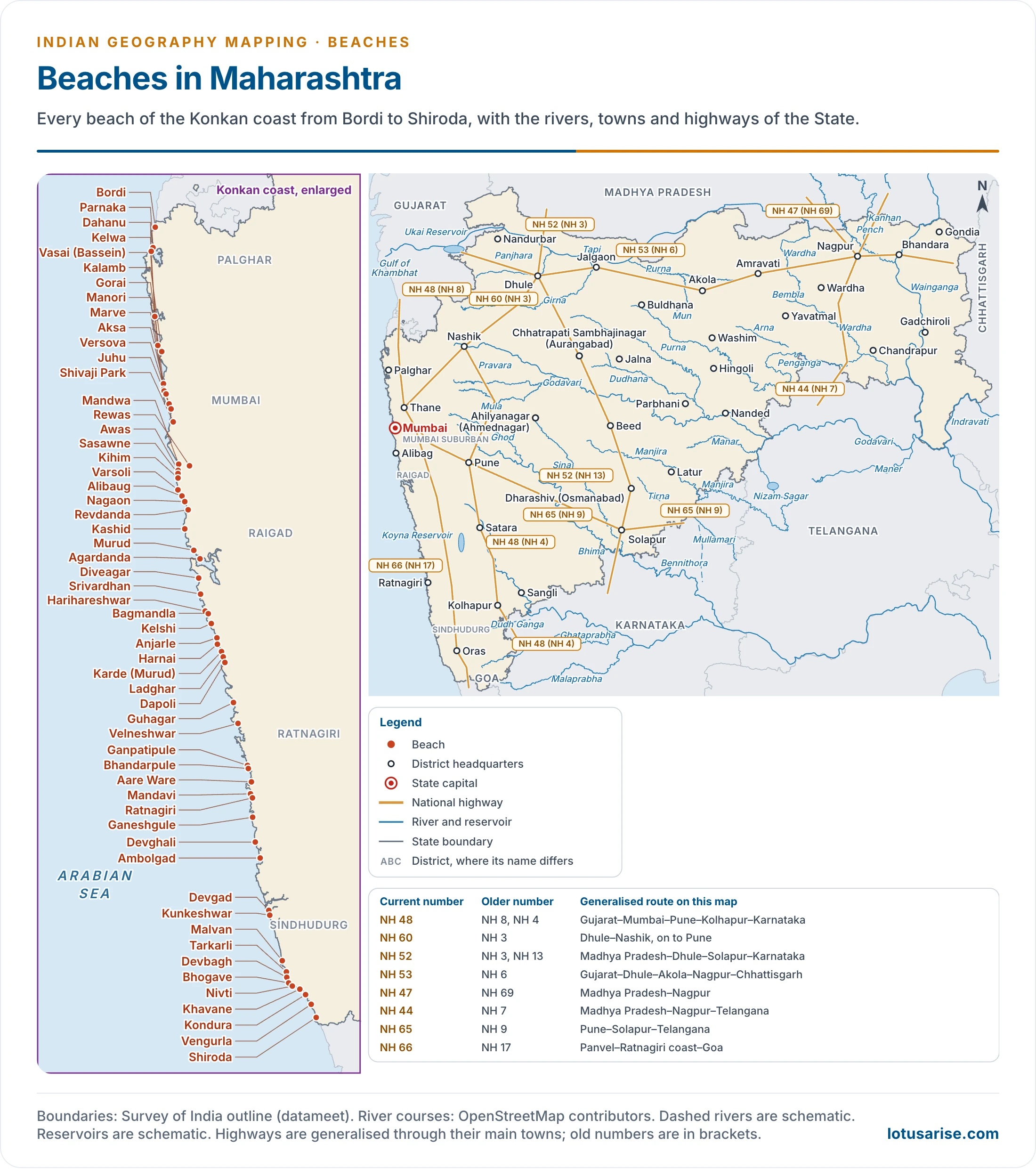
Goa
- North Goa: Arambol, Querim, Mandrem, Ashvem, Morjim, Chapora, Vagator, Anjuna, Baga, Calangute, Candolim, Sinquerim.
- Around Panaji: Miramar, Caranzalem, Dona Paula, Vainguinim, Bambolim, Siridao.
- Mormugao and Salcete: Bogmalo, Baina, Hansa, Hollant, Velsao, Cansaulim, Arossim, Utorda, Majorda, Betalbatim, Colva, Sernabatim, Benaulim, Varca, Cavelossim, Mobor, Betul.
- Far south: Canaiguinim, Cabo de Rama, Cola, Agonda, Palolem, Patnem, Rajbag, Talpona, Polem, Kakolem, Dharvalem.
- Also: Mariposa Beach Grove, Kegdole, Kalacha.
- Goa has about 40 beaches on a coast of about 105 km, and tourism is central to its economy. Anjuna, Calangute, Colva, Vagator, Candolim, Betul and Palolem are among the best known.
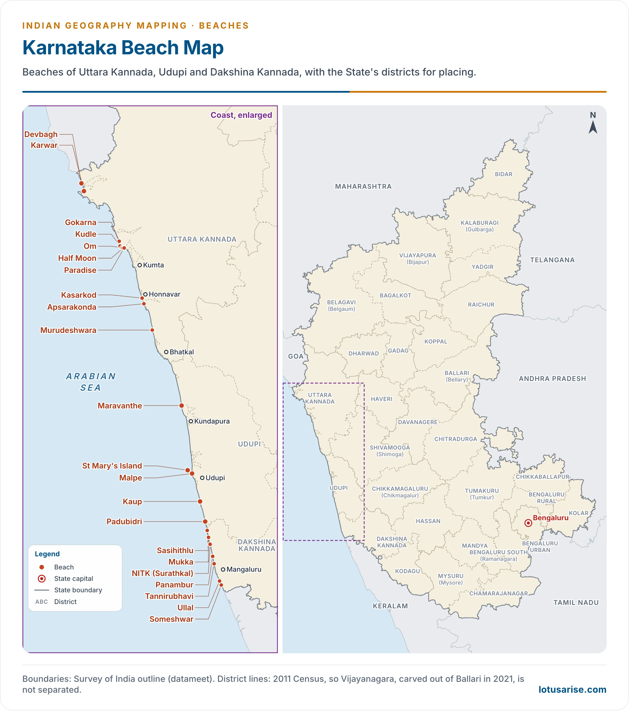
Karnataka
- Uttara Kannada: Karwar, Devbagh, Gokarna, Kudle, Om, Half Moon, Paradise, Apsarakonda, Murudeshwara, Kasarkod.
- Udupi: Maravanthe, Kaup, Malpe, Padubidri, St Mary’s Island.
- Dakshina Kannada: Sasihithlu, Mukka, NITK, Panambur, Tannirubhavi, Someshwar, Ullal.
- Om Beach at Gokarna takes its name from its shape. Murudeshwara has a temple on the sea front, and Malpe is the gateway to St Mary’s Islands.
Keralam
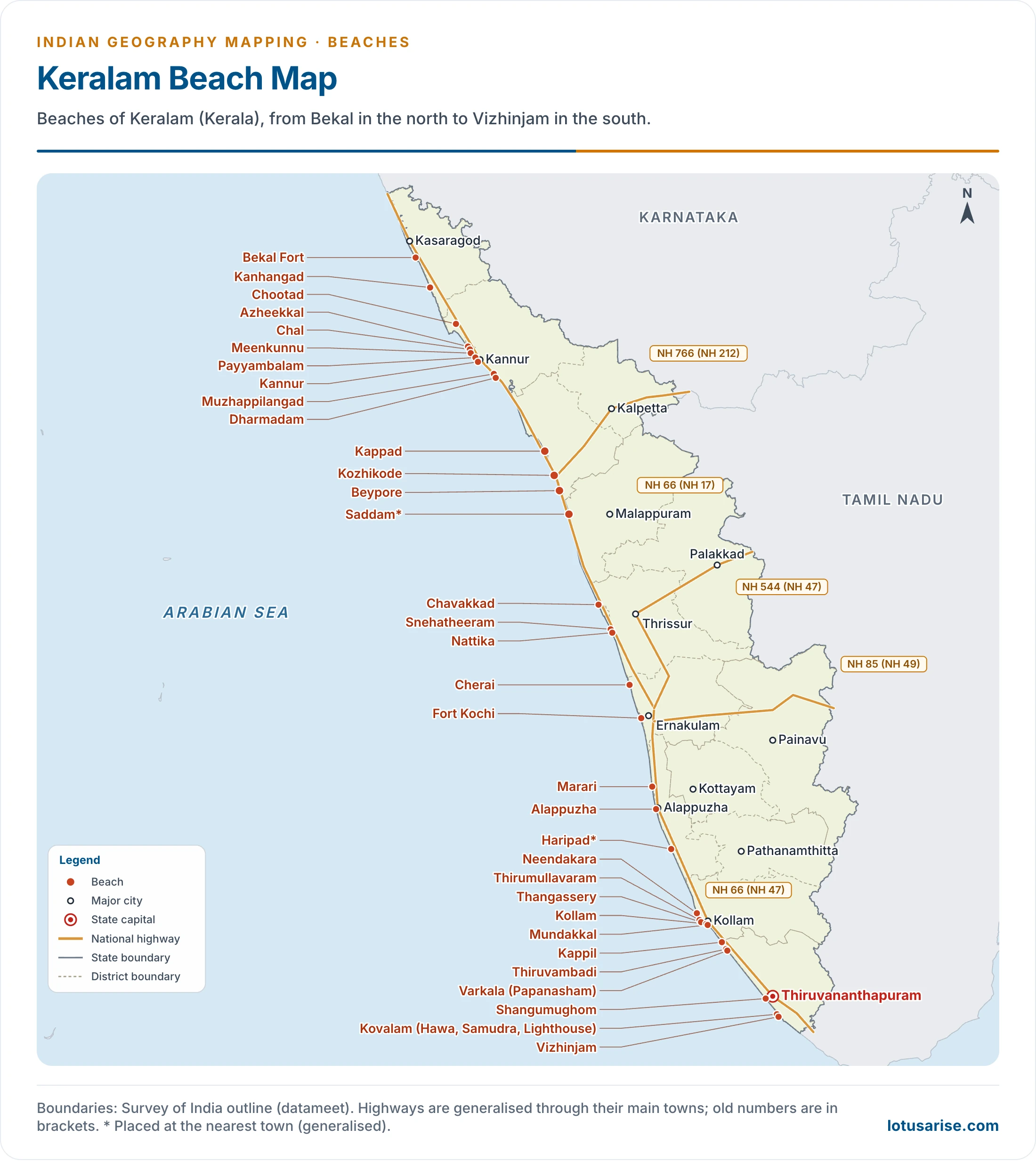
- North Malabar: Bekal, Kanhangad, Azheekkal, Payyambalam, Kannur, Chal, Meenkunnu, Chootad, Muzhappilangad, Dharmadam.
- Kozhikode and Thrissur: Kappad, Saddam, Beypore, Chavakkad, Nattika, Snehatheeram.
- Kochi and Alappuzha: Cherai, Fort Kochi, Marari, Alappuzha (Alleppey), Haripad.
- Kollam and Thiruvananthapuram: Neendakara, Thirumullavaram, Thangassery, Kollam, Mundakkal, Kappil, Varkala (Papanasham), Thiruvambadi, Shangumughom, Kovalam, Vizhinjam.
- Kovalam has three bays: Hawa, Samudra and Lighthouse Beach.
- Varkala is known for the sea cliffs of the Tertiary Varkala rocks behind its beach, and for the holy shore of Papanasham.
- Kappad is linked with Vasco da Gama’s landing of 1498, and Muzhappilangad is a long beach on which vehicles can drive.
East Coast Beaches in India
Tamil Nadu
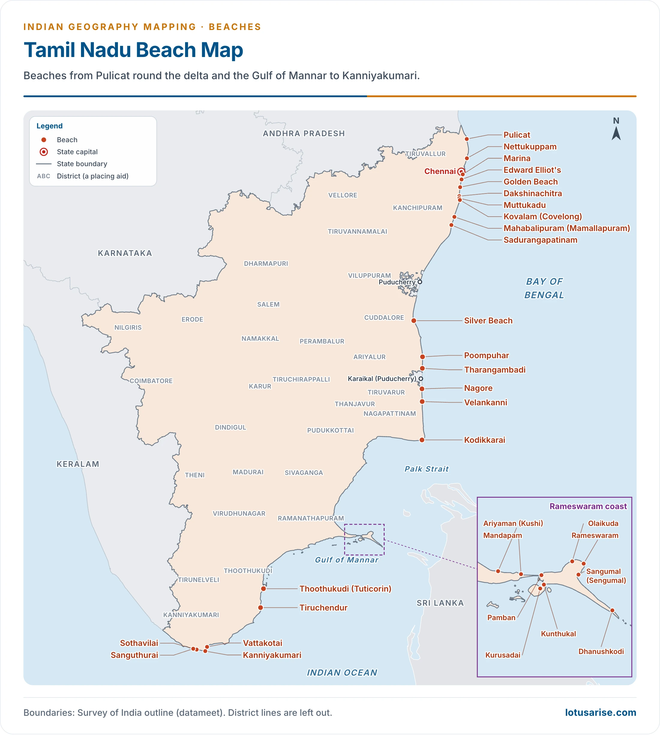
- Chennai and the north: Pulicat, Nettukuppam, Marina, Edward Elliot’s, Golden Beach, Muttukadu, Kovalam (Covelong), Mahabalipuram, Sadurangapatinam.
- Kaveri delta coast: Silver Beach, Poompuhar, Tharangambadi, Nagore, Velankanni, Kodikkarai.
- Rameswaram and the Gulf of Mannar: Olaikuda, Ariyaman, Kushi, Pamban, Dhanushkodi, Kunthukal, Kurusadai, Mandapam, Sangumal (Sengumal), Thoothukudi, Tiruchendur.
- Kanniyakumari coast: Kanniyakumari, Vattakotai, Sothavilai, Sanguthurai.
- Marina runs about 13 km (12 km in older accounts), from Chennai harbour to Santhome, and is often described as India’s longest natural urban beach.
- Tharangambadi (Tranquebar) was a Danish settlement, with Fort Dansborg on its shore. Velankanni is a Christian pilgrim centre, and Tiruchendur has a shore temple of Lord Murugan.
Andhra Pradesh
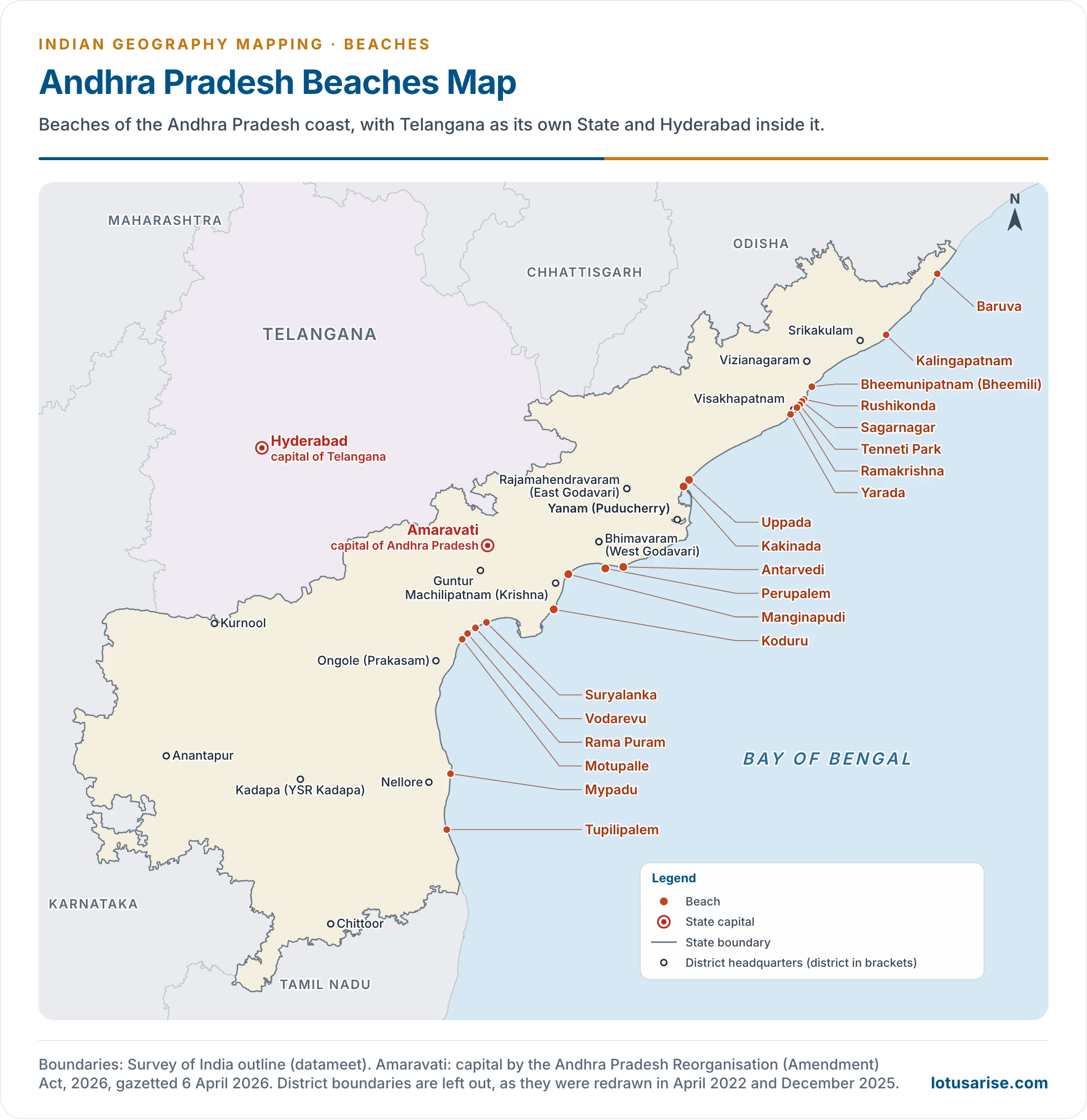
- North coast: Baruva, Kalingapatnam, Bheemunipatnam (Bheemili), Sagarnagar, Rushikonda, Tenneti Park, Ramakrishna, Yarada.
- Godavari coast: Uppada, Kakinada, Antarvedi, Perupalem.
- Krishna and Guntur coast: Manginapudi, Koduru, Suryalanka, Vodarevu.
- South coast: Rama Puram, Motupalle, Mypadu, Tupilipalem.
- Ramakrishna and Rushikonda lie close to Visakhapatnam.
Odisha
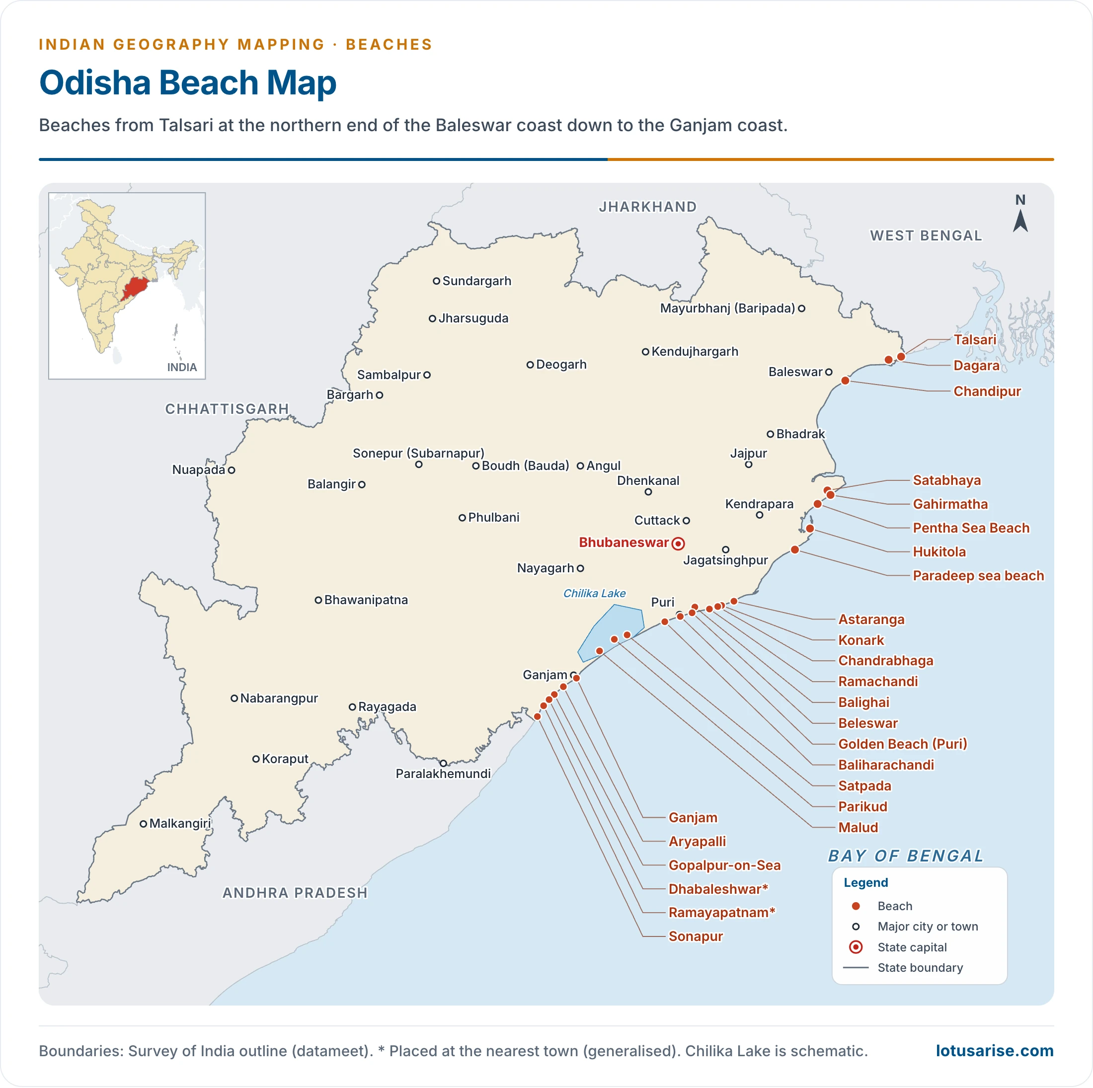
- Baleswar coast: Talsari, Dagara, Balighai, Chandipur-on-sea.
- Kendrapara and Jagatsinghpur: Gahirmatha, Satabhaya, Pentha Sea Beach, Hukitola, Paradeep sea beach.
- Puri coast: Astaranga, Ramachandi, Chandrabhaga, Konark, Beleswar, Golden Beach (Puri), Baliharachandi, Satpada, Parikud.
- Ganjam coast: Malud, Ganjam, Gopalpur-on-Sea, Dhabaleshwar, Ramayapatnam, Aryapalli, Sonapur.
- Chandipur, about 16 km from Balasore town, has a “vanishing sea”: the water draws back up to about 5 km at low tide, on a very gentle slope.
- Gopalpur is backed by sand dunes, and Gahirmatha is an Olive Ridley turtle shore.
West Bengal
- Purba Medinipur coast: Digha Sea Beach, Udaypur Sea Beach, Shankarpur, Tajpur, Mandarmani, Junput, Bankiput Sea Beach.
- South 24 Parganas: Bakkhali sea beach, Frasergunj Sea Beach, Henry Island Beach, Gangasagar Sea Beach, Sagar Island, Diamond Harbour, Falta.
- Digha, near the mouth of the Ganga, is about 6 km long, with casuarina groves on a gently sloping shore.
Puducherry
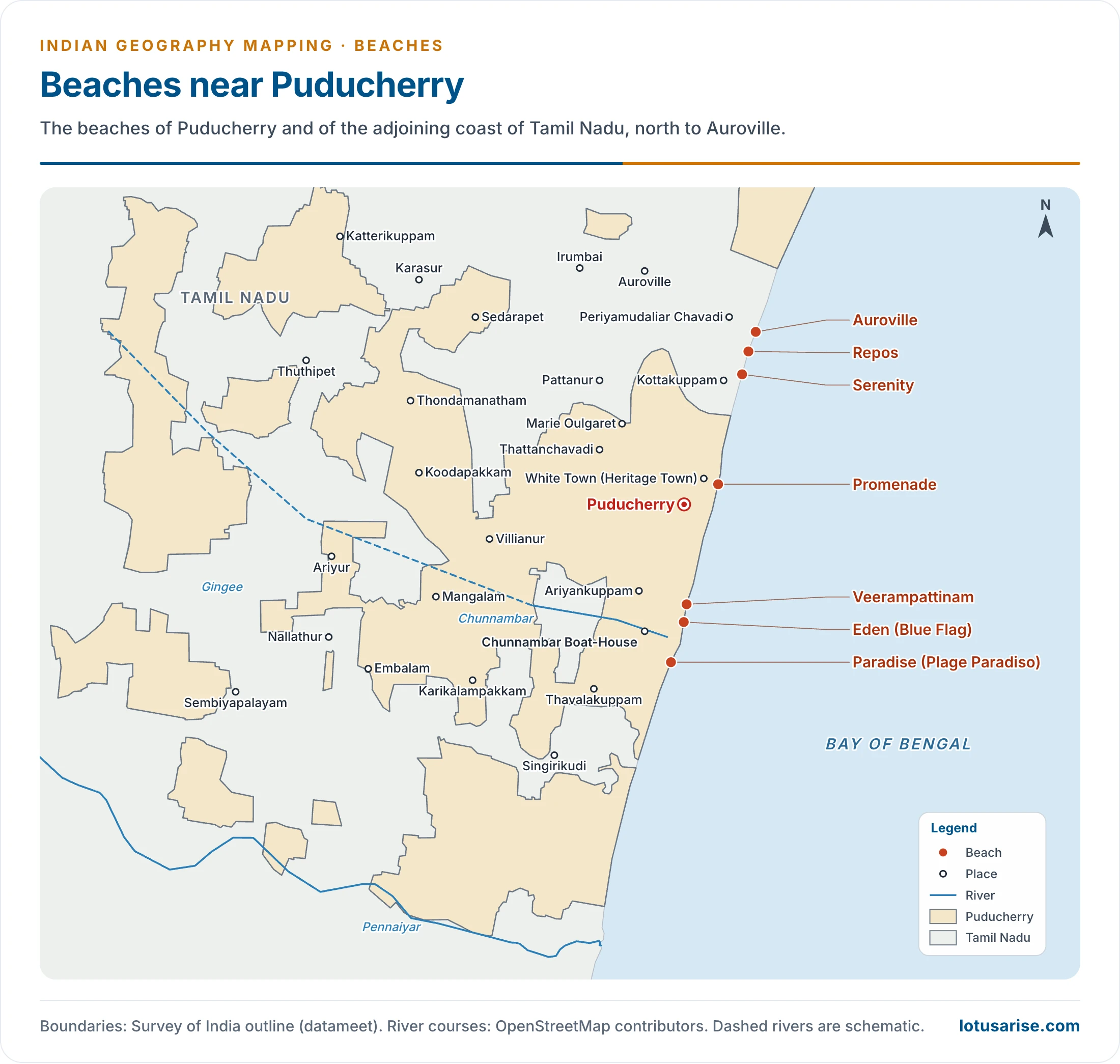
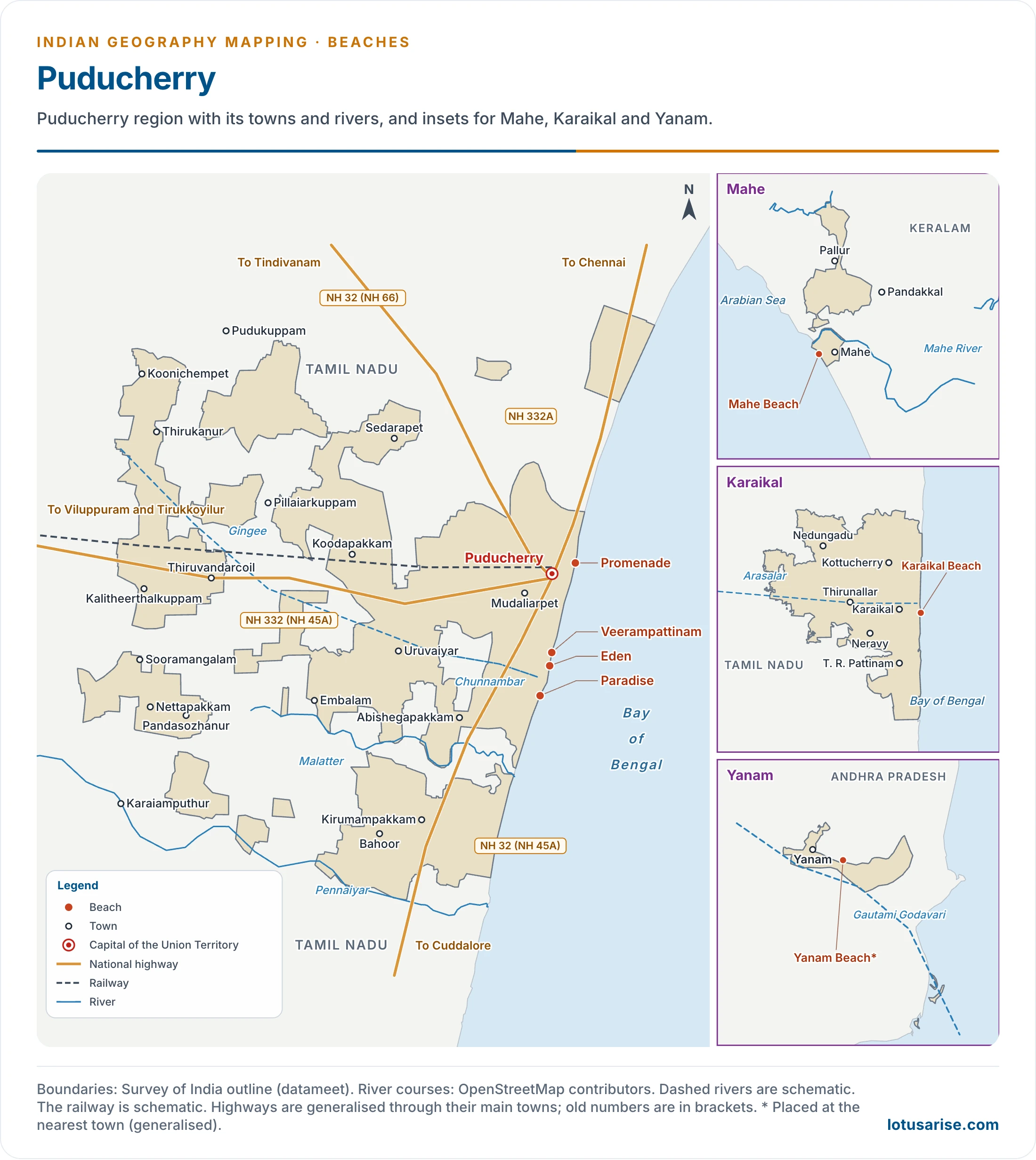
- Puducherry town and nearby: Promenade, Paradise, Veerampattinam, Eden, Repos.
- Adjoining coast of Tamil Nadu: Serenity and Auroville.
- Other parts of the Union Territory: Karaikal, Yanam.
Island Territories
Beaches in Lakshadweep
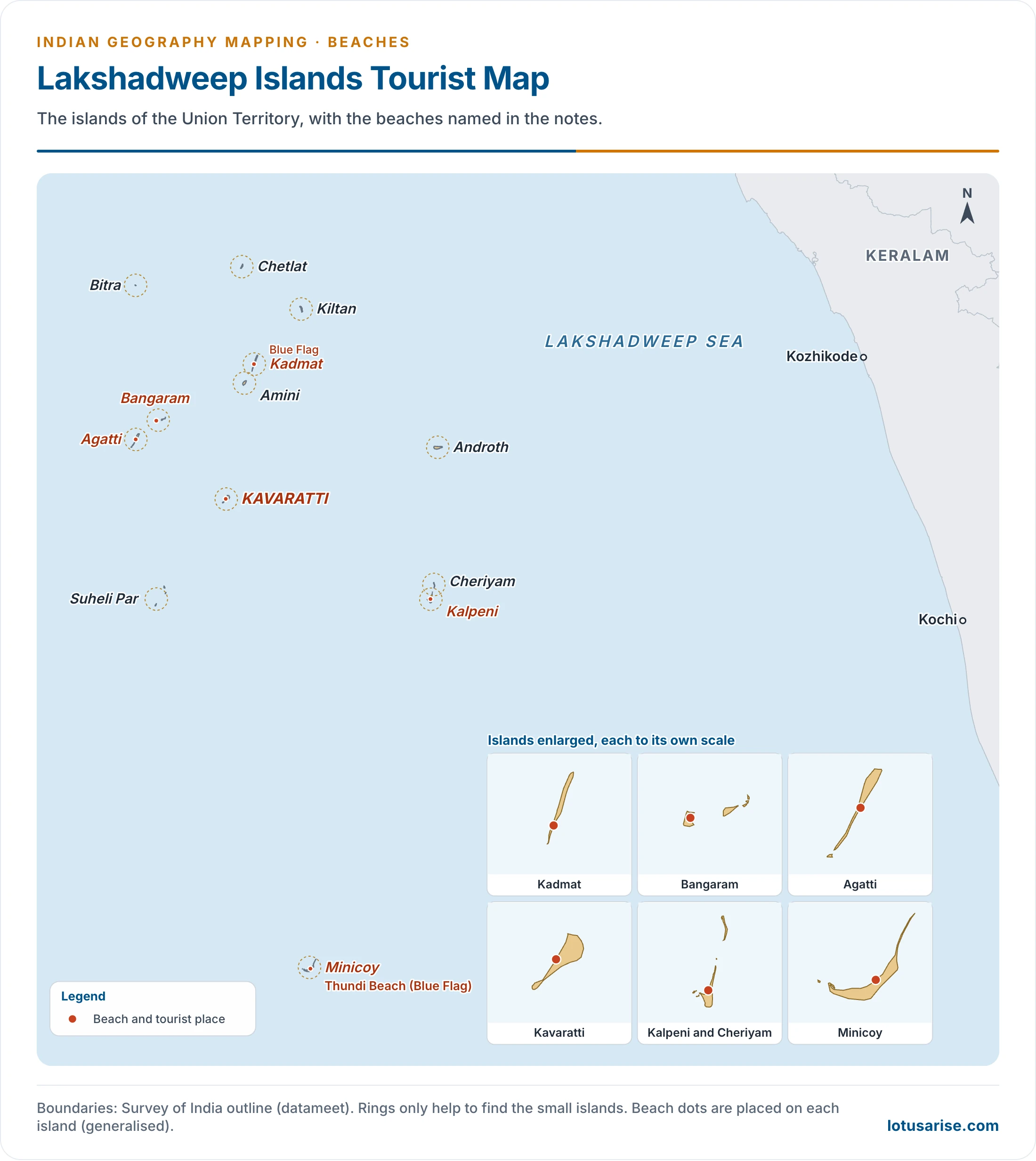
- Bangaram, Kadmat, Agatti, Kalpeni, Kavaratti Island and Minicoy.
- Thundi beach on Minicoy holds the Blue Flag along with Kadmat.
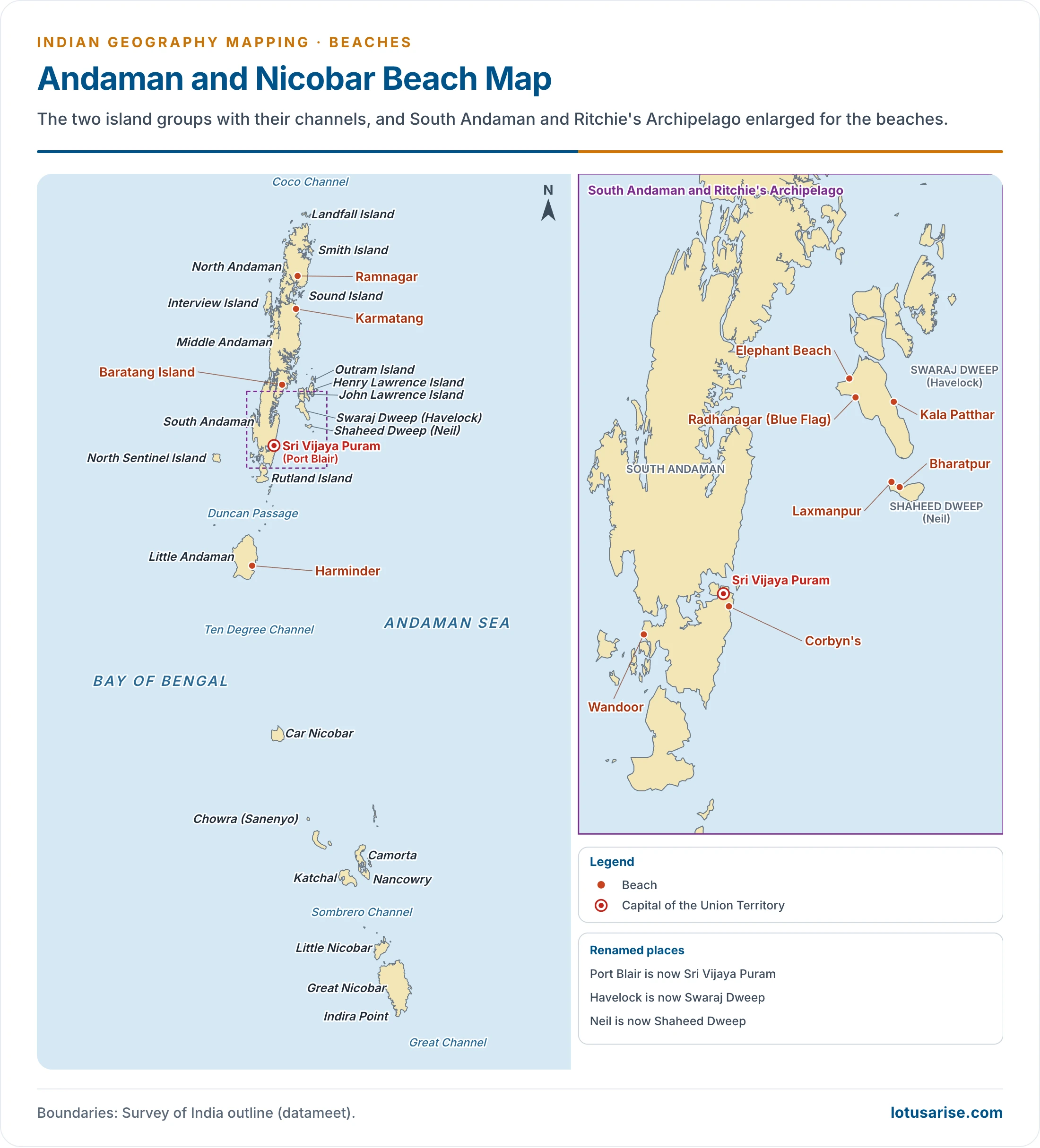
Beaches in Andaman and Nicobar Islands
- Swaraj Dweep (Havelock): Radhanagar, Kala Patthar, Elephant Beach.
- Shaheed Dweep (Neil): Bharatpur, Laxmanpur.
- Sri Vijaya Puram (Port Blair) and South Andaman: Corbyn’s, Wandoor.
- North and Middle Andaman: Ramnagar, Karmatang, Baratang Island.
- Radhanagar was named “Best Beach in Asia” by Time magazine in 2004, and it holds the Blue Flag.
Previous Year Questions
2026Map item: Varkala2022Map item: Tarangambadi2021Map item: Digha Beach2020What are the characteristics of Blue Flag certified beaches? Discuss their significance for beach tourism in India.2015Map item: Tharangambadi2014Map item: Chandipur





Excellent contents @LotusArise IAS. One small correction – In Odisha beach map, you have pointed Talsari beach near Ganjam, but actually it is in Balasore district in north-eastern point of Odisha.