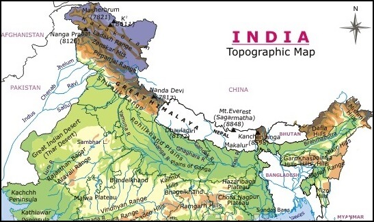
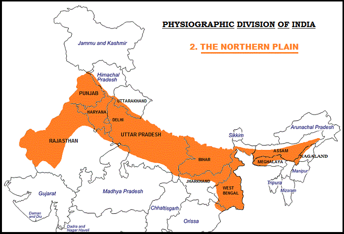
The northern plains have been formed by the interplay of the three major river systems, namely the Indus, the Ganga, and the Brahmaputra along with their tributaries.
This plain spreads over an area of 7 lakh sq. km. The plain being about 2400 Km long and 240 to 320 Km broad, is a densely populated physiographic division.
With a rich soil cover combined with an adequate water supply and favorable climate, it is agriculturally a very productive part of India.
They lie to the south of the Shivaliks, separated by the Himalayan Frontal Fault (HFF). The southern boundary is a wavy irregular line along the northern edge of Peninsular India. On the eastern side, the plains are bordered by the Purvanchal hills.

Northern Plains of India
Punjab Plains
- The Punjab plains form the western part of the northern plain.
- In the east, the Delhi-Aravalli ridge separates it from the Ganga plains.
- This is formed by the Indus and its tributaries; like Jhelum, Chenab, Ravi, Beas and Sutlej. A major portion of these plains is in Pakistan.
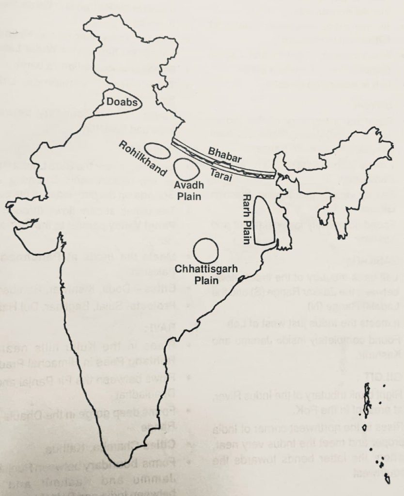
- It is divided into many Doabs (do-“two” + ab- “water or river” = “a region or land lying between and reaching to the meeting of the two rivers”).
Punjab Doabs
- Sindh Sagar Doab
- The Sindh Sagar Doab lies between the Indus and Jhelum rivers.
- Jech Doabs
- The Jech Doab (also Chaj Doab) (small portion of the Jech Doab is Majha lies between the Jhelum and Chenab rivers.
- Rechna Doab
- The Rechna Doab (considerable portion of the Rechna Doab is Majha lies between the Chenab and Ravi rivers.
- Bari Doabs
- The Bari Doab (considerable portion of the Bari Doab is Majha lies between the Ravi and Beas rivers.
- Bist Doab
- The Bist Doab (or Doaba) – between the Beas and Sutlej rivers.
Ganga Plains
- The Ganga plains lie between the Yamuna catchment in the west to the Bangladesh border in the East.
- The lower Ganga plain has been formed by the downwarping of a part of the Peninsular India between Rajmahal hills and the Meghalaya plateau and subsequent sedimentation by the Ganga and Brahmaputra rivers.
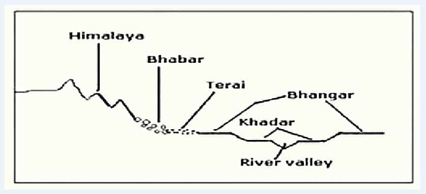
- The main topographical variations in these plains include Bhabar, Tarai, Bhangar, Khadar, levees, abandoned courses etc.
- Almost all the rivers keep on shifting their courses making this area prone to frequent floods. The Kosi river is very notorious in this respect. It has long been called the ‘Sorrow of Bihar’.
- The northern states, Haryana, Delhi, UP, Bihar, part of Jharkhand and West Bengal in the east lie in the Ganga plains.
- The Ganga-Brahmaputra delta: the largest delta in the world. A Large part of the coastal delta is covered tidal forests called Sunderbans. Sunderbans, the largest mangrove swamp in the world gets its name from the Sundari tree which grows well in marshland. It is home to the Royal Tiger and crocodiles.

Ganga Doab
- Upper Doab
- Uttarakhand:
- Dehradun and Haridwar
- Uttar Pradesh:
- Saharanpur, Shamli, Muzaffarnagar, Baghpat, Meerut, Ghaziabad, Hapur, Gautam Buddh Nagar and Bulandshahr
- Delhi
- Uttarakhand:
- Central or Middle Doab
- Etah, Kasganj, Aligarh, Agra, Hathras, Firozabad, Farrukhabad, Kannauj, Mainpuri, Etawah, Auraiya and Mathura. Mathura is in the trans-Yamuna region of Braj.
- Lower Doab
- Kanpur, Fatehpur, Kaushambi and Allahabad.
Rohilkhand Plain
- Rohilkhand, low-lying alluvial region is located in northwestern UP, on the upper Ganges alluvial plain.
- Between the Ganga River (West) and the Avadh Plain (East).
- Named after the Rohilla tribe, and was known as Madhyadesh in the Mahabharata.
- Rohillas were the Pathan highlanders of the Yusufzai tribe
Awadh Plain
- Central part of UP between Purvanchal (E) and the Rohilkhand (W)
- Earlier known as the granary of India
- Known for its unique cuisines and culture
- Cities – Lucknow, Kanpur, Rae Barelly, Faizabad
Rarh Plain
- The Rarh region lies between the Chota Nagpur Plateau on the west and the chief flow of the Ganges River (which has been continuously changing) in the east.
- The Rarh plains comprise the lower Gangetic plains to the south of the Ganges river, and to the west of its Bhagirathi-Hooghly distributary.
- These plains are formed of old alluvial deposits. The elevation ranges between 75 and 150 m
- The main river being Damodar
- Highly industrialized region
- Earlier ill famous for disastrous floods.
Malwa Doab
- The rivers flowing through the Malwa region, covering current states of Madhya Pradesh and parts of north-eastern Rajasthan, also has doab region such as Upper Malwa doab and Lower Malwa doab.

Chhattisgarh Plain
- The Chhattisgarh plain is the only plain worth the name in the Peninsular plateau.
- It is a saucer shaped depression drained by the upper Mahanadi.
- The whole basin lies between the Maikala Range and the Odisha hills.
- It is bounded by the Chota Nagpur plateau to the north, the Raigarh hills to the northeast, the Raipur Upland to the southeast, the Bastar plateau to the south, and the Maikala Range to the west.
- The region was once ruled by Haithaivanshi Rajputs from whose thirty six forts (Chhattisgarh) it derives its name.
- The basin is laid with nearly horizontal beds of limestone and shales.
- Famous as the ‘rice bowl of India’
- Extensive coal deposits and substantial deposits of iron ore, bauxite, manganese, and commercial clays have aided its development.
- The general elevation of the plain ranges from 250 m in the east to 330 m in the west.
- Bhilai, Bilaspur, Raipur, Raigarh, and Durg are the chief commercial centres. Korba, Nandgaon, and Rajgarh are other developing urban centres.
Raichur Doab
The Raichur Doab is the triangular region of Andhra Pradesh and Karnataka states which lies between the Krishna River and its tributary the Tungabhadra River, named for the town of Raichur.

.

Beautifully explained.