

The global distribution of vegetation and fauna follows a distinct zonal pattern — running latitudinally from the equator towards the poles, and altitudinally from sea level to the vegetation limit on high mountains.
The world distribution of plants (phytogeography) and animals (zoogeography) refers to the patterned, non-random arrangement of flora and fauna across the Earth’s surface — a pattern produced by the interaction of present-day environmental controls with the deep evolutionary and tectonic history of the continents.
This dual distribution is never random. It follows a discernible zonal pattern — vegetation belts shift systematically from the equator towards the poles (a latitudinal gradient) and from sea level to the tree-line/snow-line on high mountains (an altitudinal gradient). Since similar climatic conditions recur at different latitudes and altitudes across the globe, comparable vegetation and animal assemblages tend to reappear wherever those conditions are replicated — the foundational insight of classical biogeography.
Factors Controlling the Distribution of Plants and Animals

The distribution of plants (and, by extension, the animals dependent upon them) is affected and controlled by a wide variety of interacting factors:
| Factor Group | Key Elements |
|---|---|
| Climatic factors | Sunlight, temperature, moisture and humidity, precipitation, soil moisture |
| Edaphic factors | Soil nutrients, soil texture, soil structure, acidity/alkalinity, nature and properties of soil profiles |
| Biotic factors | Effects of living organisms — chiefly animals and humans — on a habitat’s plants; inter-species interactions such as natural selection, competition, mutualism and parasitism |
| Physical factors | Relief and topography, slope angle, gradient, and slope aspect |
| Tectonic factors | Continental displacement and drift, plate movements, endogenetic forces, volcanicity and seismic events |
| Fire factor | Natural forest fires (triggered by lightning) and man-induced fires (both intentional and accidental) |
| Dispersion of plants | Wind, water, animal-mediated and human-mediated seed/spore dispersal |
| Human interference | Deforestation, plantation, urbanisation, agriculture, and deliberate species introduction |
Approaches to Studying Plant Distribution
The distribution of plants may be studied in a variety of complementary ways:
- On the basis of habitats — i.e., separately for terrestrial and aquatic plants
- On the basis of floral divisions (floristic kingdoms, provinces and regions)
- On the basis of latitudinal and altitudinal extents
- On the basis of the characteristic features of plant communities (life-forms, dominant species, canopy structure, etc.)
Extended Theoretical Framework (Beyond the Basic Factor List)
While the eight factor groups above form the core syllabus content, a fuller UPSC-level treatment should also incorporate the following refinements, which examiners frequently expect in a 20-mark answer:
- Thermal limits and growing season: Every species has an upper and lower temperature tolerance; the length of the frost-free growing season directly limits which plants can complete their life cycle in a given zone.
- Moisture regime classification: Plants are grouped as xerophytes (drought-adapted, e.g., cacti), mesophytes (moderate moisture, e.g., temperate deciduous trees) and hydrophytes (aquatic/waterlogged habitats, e.g., water lilies).
- Photoperiodism: The response of flowering and growth cycles to day-length, which varies systematically with latitude and season.
- Altitudinal zonation: With increasing elevation, temperature falls at the environmental lapse rate, reproducing — within a single mountain slope — a compressed version of the equator-to-pole latitudinal sequence (tropical → temperate → alpine → nival belts, as seen classically in the Himalayas).
- Rain-shadow effect: Windward and leeward slopes of mountain barriers can show sharply contrasting vegetation due to orographic precipitation differences (e.g., the arid Ladakh trans-Himalayan zone versus the wet southern Himalayan slopes).
- Barriers to dispersal: Oceans, deserts, and mountain ranges act as filters or complete barriers to plant and animal movement, and are the principal reason that biogeographic realms/regions retain distinct identities despite occupying similar climatic belts.
- Historical/evolutionary factors: The break-up of the supercontinents Gondwanaland and Laurasia through continental drift is the single most important historical explanation for why related plant and animal taxa are found today on widely separated continents (e.g., Nothofagus in South America, New Zealand and Australia).
- Island biogeography theory (MacArthur & Wilson, 1967): Species richness on an island is a dynamic equilibrium between immigration rate (which falls with distance from the mainland) and extinction rate (which falls with increasing island area) — a theory directly relevant to understanding depauperate island faunas such as that of Hawaii (discussed below).
📝 Exam Tip: When answering “Discuss the factors influencing world distribution of plants and animals,” always distinguish ecological/contemporary factors (climate, soil, biotic interaction) from historical/evolutionary factors (continental drift, dispersal, isolation) — examiners reward this two-tier structure highly.
World Distribution of Plants — The Six Floristic Kingdoms
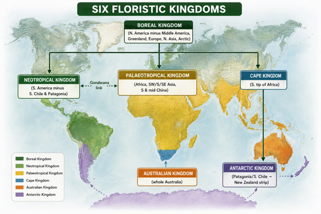
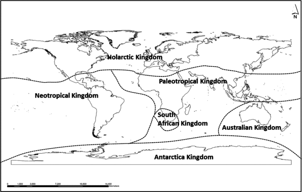
The land plant species of the world are grouped into six major floristic kingdoms on the basis of their worldwide distribution — a classification most closely associated with the biogeographer Ronald Good (1974), whose scheme remains the standard reference framework in plant geography.
1. Australian Kingdom:
This floristic kingdom includes the plants of the whole of Australia, characterised by a typical and highly dominant genus — Eucalyptus. The different species of this unique genus are so dominant in Australia that they represent 75 percent of all Australian plants. There are over 600 species of eucalyptus, which vary greatly in their general characteristics, ranging from tall, giant, shady eucalyptus trees to dwarf and stunted desert eucalyptus trees.
Eucalyptus is said to be related to mimosa, which is still found (in only a few species) in South America. Eucalyptus has been deliberately dispersed and distributed by man from Australia to almost every continent — extensive plantations of eucalyptus can be seen in India, particularly along rail and road sides, and it continues to be expanded rapidly through deliberate human action across the country, irrespective of environmental suitability for this exotic plant.
The typical endemic flora of Australia, with its unique characteristics, developed due to the continent’s isolation from other southern-hemisphere continents because of continental drift — the same evolutionary process discussed under historical factors above.
2. Cape Kingdom:
This floral kingdom developed in the southern tip of Africa, where plants bearing bulbs and tubers have developed — the typical plant forms of this kingdom. These plants belong to the category of cryptophytes, which bear buds in the form of bulbs and tubers buried in the soil; new shoots emerge from these bulbs and tubers to develop into fresh plants.
These plants represent the majority of garden flowering plants of the region — e.g., Loplia, Kniphofia, Erica, Freesia. Their global dispersal became possible when South Africa was colonised by Europeans, who carried these garden flowering plants to gardens across the rest of the world.
- There is a gradual decrease in the number and area of these garden flowering plants in their own native range (southern South Africa), as their habitat is continuously replaced by agricultural land.
- Untouched areas still retain sclerophyllous shrubs attaining a height of a few metres, with an undergrowth of herbaceous shrubs.
- The native vegetation of this region, prior to European colonisation, consisted of temperate evergreen forests, which were extensively cleared for agriculture — the sclerophyllous shrub cover developed later as a secondary succession of vegetation.
3. Antarctic Kingdom:
This kingdom includes a narrow strip running from Patagonia and southern Chile in South America to New Zealand. The most important representative plant of this zone is Nothofagus, also known as the Southern Beech. About 100 million years ago, temperate grasses developed as the native vegetation of this region (specifically New Zealand).
The most outstanding and typical grass species were Tussock Grasses, though a few species of Sedges (water-growing plants) and dicotyledon shrubs also developed. This original native vegetation has undergone massive modification since the European colonisation of New Zealand. Present-day New Zealand vegetation is of the modified type, still characterised by two types of tussock grassland:
- Short Tussock Grasslands — two main species, Festuca and Poa; average height up to 0.5 m; yellow-grey colour.
- Tall Tussock Grasslands — main species Chionochloa.
Warm temperate areas of New Zealand are dominated by forests of gymnosperms and angiosperms. The main coniferous gymnosperm families are Podocarpaceae, Cupressaceae, and Araucariaceae, while Nothofagus is the most important angiosperm (flowering plant). The sub-tropical forests of New Zealand are evergreen, characterised by a dense cover of tall trees with distinct vertical strata of other plants.
The original vegetation of New Zealand has been greatly modified and destroyed by human activities and by introduced mammals — mainly grazing red deer and rabbits brought from Europe — leading to large-scale destabilisation of vegetation communities.
4. Palaeotropical Kingdom:
This kingdom includes most of Africa, South West Asia, South Asia, South East Asia, and the southern and middle portions of China. This floral kingdom is further divided into 3 sub-kingdoms e.g.:
- African sub-kingdom,
- Indo-Malaysian sub-kingdom, and
- Polynesian sub-kingdom.
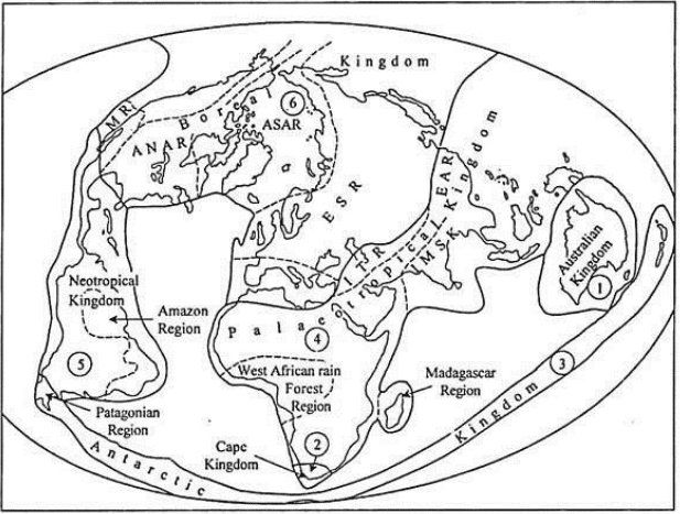
This floral kingdom is also divided into several floral provinces or regions e.g., West African rainforest region, Madagascar region, Iran-Turanian region, East Asian region, etc. There is great variation in plant species from one region to another region but few plants are common to all sub-kingdoms and regions.
5. Neotropical Kingdom:
This region includes the whole of South America except southern Chile and Patagonia. A few genera are common to this kingdom and the palaeotropical kingdom, mainly Africa, because the original flowering plants developed in South America and Africa during the Cretaceous period, when all members of Gondwanaland were united together.
Later on the spreading of the Atlantic sea-floor, disruption of Gondwanaland and westward drift of South America from Africa became responsible for the origin and development of new species at the regional level and therefore variations in the plant species of South America and Africa were introduced.
6. Boreal Kingdom:
This floral kingdom includes the whole of North America except Middle America, Greenland, entire Europe, northern Asia, and the Arctic region.
This is the most extensive kingdom of all the floral kingdoms. This is again divided into several sub-kingdoms and regions or provinces e.g. Rocky Mountainous Region (RMR); Atlantic – North American Region (ANAR, fig.); Arctic and Sub-Arctic Region (ASAR); Europe-Siberian Region (ESR); Mediterranean Region (MR), etc.
World Distribution of Animals
The study of the distributional patterns of animals at the global scale is carried out in different ways:
- A species-level study — a collective study of the distributional patterns of all members of a particular species, involving division of animals into definite distributional areas based on species abundance.
- A community-level study — considering and studying the total population of all individuals of all species of a given region.
It must be emphasised that the distributional patterns of animals at global or regional levels are more complex than the distribution of vegetation, because animals are far more mobile. Consequently, no animal species is universally distributed, as several factors distort the uniformity of distributional patterns.
Key Principles Governing Land Animal Distribution
The following facts must be taken into account while studying world distributional patterns of animals:
- Physical environmental conditions determine the number, abundance, and diversity of animals. Maximum diversity is noticed among the vertebrate animals of the land and freshwater habitats of the tropical regions.
- There is a zonal pattern in the world distribution of animals, occurring in two forms: (i) Horizontal zones, and (ii) Vertical zones.
- Latitude exercises maximum control over horizontal zonal patterns, because sunlight decreases from the equator towards the poles — meaning a corresponding decrease in vegetation and its diversity towards increasing latitudes, and hence a decrease in species diversity from the equator towards the poles as well.
- The origin and evolution of animals first took place in the tropical/equatorial regions, from where animals were dispersed to other areas. The development of animal zones in higher latitudes thus occurred because of the dispersal and migration of animals from tropical zones.
- The horizontal animal zones of higher latitudes are therefore the result of dispersal, migration, and various phases of speciation. For example, the temperate animal zone developed due to the “subtraction” of animals during their migration from the tropical zone.
- Animals have radiated in all directions from their centres of origin, dispersing and migrating through various routes. Consequently, the distributional patterns of world fauna are found in concentric zones.
- The diversity of animals in any region is the result of several phases of their dispersal and colonisation.
- A high degree of concentration (endemism/species clustering) is possible mainly among mammals, whereas the distribution of other animal classes is more widespread and less region-specific.
- Distributional patterns are not uniform — some species show continuous distribution, others discontinuous (disjunct) distribution:
- Continuous example: The moose (a type of deer) shows a continuous zonal distribution across the taiga regions of North America and Eurasia.
- Discontinuous example: The Azure-winged Magpie, weather fish, and bitterling show discontinuous distribution — their two distribution zones, in middle/western Europe and in south-east Asia, are separated by an extensive zone devoid of these animals.
- Oceanic islands are characterised by special types of animals, since there has been minimum migration and dispersal to islands owing to great oceanic barriers. Hawaii Island, which was never connected to any landmass in the Earth’s geological history, lacks reptiles, amphibians, freshwater fishes, and mammals (except one species of bat) — a classic real-world illustration of the island biogeography principle noted earlier.
Historiography of Faunal Region Classification
A.R. Wallace first attempted the classification of world animals into faunal regions in 1876. Since then, several scientists have proposed their own divisions of world fauna:
| Scientist | Year |
|---|---|
| P.J. Darlington | 1957 |
| S.C. Kendleigh | 1961 |
| W. George | 1962 |
| De Latin | 1967 |
| W.T. Neil & M.D.F. Udvardy | 1969 |
| De Laubenfels | 1970 |
| J. Illies | 1974 |
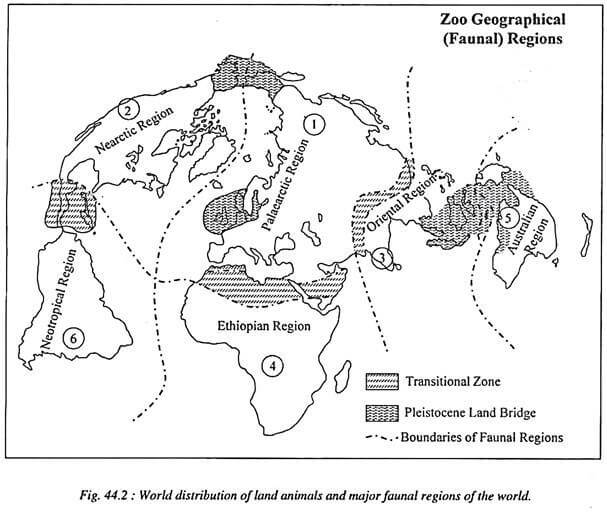
Despite these subsequent efforts, Wallace’s original 1876 division remains the most convincing and widely accepted classification of world fauna. Normally, the world is divided into six major faunal regions: Palaearctic, Nearctic, Oriental, Ethiopian, Australian, and Neotropical.
📝 Exam Tip: Wallace’s six faunal-region names map closely onto today’s eight biogeographic realms as follows: Oriental → Indomalayan, Ethiopian → Afrotropical, Australian → Australasian, while Palaearctic, Nearctic and Neotropical retain identical names. The modern scheme additionally separates out Oceanian and Antarctic realms. Cross-referencing both naming systems in an answer demonstrates strong command of the topic’s historiography.
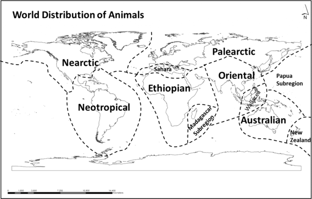
1. Palaearctic Region (Europe and middle/north Asia):
Palaearctic region includes Europe and the Middle and North Asia, which represent 28 chordate families. This region represents 28 chordate families. Important animals include Russian desmans, dormice of Eurasia, Mediterranean mole rats, saiga and chiru antelope, accentors, crocodiles, and lizards — though reptiles are found in relatively small numbers.
This faunal region is further divided into five sub-regions on the basis of vegetation:
| Sub-region | Characteristic Animals |
|---|---|
| Tundra region | Caribou, lemming, muskox, arctic hare, arctic fox, wolf, polar bear |
| Temperate coniferous forest region | Moose, mule deer, lynx |
| Temperate grassland region | Saiga, wild ass, horse, camel, jerboa, hamster, jackal |
| Deciduous forest region | Raccoons, opossum, red fox, black bear |
| Desert region | Lizards, snakes, hamster, hedgehog, rats, jerboa, cottontail |
The Palaearctic faunal region includes 136 families of vertebrate animals, 100 genera of mammals, and 174 genera of birds. Additionally, 3 unique families of vertebrates, and 35 and 57 unique genera of mammals and birds respectively, are found exclusively in this region.
2. Nearctic Region (North America and Greenland):
There is much similarity between the Palaearctic and Nearctic faunal regions, since both were historically connected through the Bering Land Bridge during the Tertiary Epoch and Pleistocene periods. This land bridge enabled free exchange and migration of animals between the two regions, resulting in significant species mixing and increased diversity.
- For example, American and European bison can reproduce through sexual intercourse between them; both regions also share salmon and trout.
- On the basis of such biological similarities, some scientists group the Palaearctic and Nearctic together into a single Holarctic region.
- Horses, pigs, goats, and sheep were originally absent from the Nearctic region — these animals later migrated to North America from north-eastern Asia via the Bering Strait land bridge.
The Nearctic region is characterised by a few special/typical animals such as pocket gophers, pocket mice, pronghorns, and wild turkeys; reptiles are found in large numbers. There are 122 families of all vertebrates, 74 genera of mammals, and 169 genera of birds — plus 12 unique families of invertebrates, 24 unique genera of mammals, and 52 unique genera of birds.
Like the Palaearctic, the Nearctic region is also divided into five sub-faunal regions on the basis of vegetation:
| Sub-region | Characteristic Animals |
|---|---|
| Tundra region | Caribou, musk ox, lemming, arctic wolf, arctic fox, polar bear (genera same as Palaearctic tundra; species differ) |
| Temperate coniferous forest region | Moose, mule deer, wolverine, lynx |
| Temperate grassland region | Bison, pronghorn, jackrabbit, prairie dog, gopher, fox, coyote |
| Deciduous forest region | Raccoons, opossum, red fox, black bear (genera almost same as Palaearctic; species differ) |
| Desert region | Lizards, snakes, kangaroo rat, jerboa, hamster, hedgehog, cottontail |
3. Oriental Region:
The Himalayas, Tibetan Plateau, and Chinese mountainous regions form transitional zones between the Palaearctic and Oriental faunal regions; similarly, the East Indies form a transitional zone between the Oriental and Australian faunal regions. The whole of this faunal region falls within the tropics and is therefore ecologically associated with the Ethiopian faunal region.
This region represents 164 families of all vertebrates, 118 genera of mammals, and 340 genera of birds — of which 12 unique families of vertebrates, 55 unique genera of mammals, and 165 unique genera of birds occur exclusively here.
This faunal region is characterised by the dominance of Indian elephants, rhinos, several species of deer, antelopes, pheasants, tigers, lizards, snakes, gibbons, monkeys, sun bears, and porcupines. Tree shrews, gibbons, orangutans, and tapirs are the typical/signature animals of the Oriental faunal region.
4. Ethiopian Region
South-western Arabia is included in this region despite being separated from the African mainland by the Red Sea. This region also falls under tropical climatic conditions. Unlike other faunal regions, it is characterised by a somewhat lower overall diversity, and shows the complete absence of moles, beavers, bears, and camels.
This region represents 174 families (22 unique) of vertebrate animals, 140 genera (90 unique) of mammals, and 294 genera (179 unique) of birds. It is further divided into three sub-regions:
| Sub-region | Characteristic Animals |
|---|---|
| Desert region | Springbok, porcupine, jerboa, rock hyrax |
| Savanna region | Zebra, eland, gemsbok, hartebeest, gnu (wildebeest), giraffe, elephant, ostrich, lion, cheetah |
| Tropical forest region | Okapi, gorilla, chimpanzee, monkey, forest elephant |
There is similarity in a few animals of the Oriental and Ethiopian faunal regions, such as elephants, lions and cheetahs. Meanwhile, the hippopotamus, aardvark, ostrich, and rodents, along with a few species of insectivorous animals, are found exclusively in the Ethiopian faunal region.
5. Australian Region:
Australian region includes Australia, New Zealand, and islands between S.E. Asia and Australia (such as New Guinea, Soloman, Samoa, etc.). Some scientists do not include New Zealand in the Australian faunal region. There is a difference of opinions among the scientists about the linkage of this region with the oriental faunal region. This region is dominated by placental animals. Marsupials (characterized by pouch attached to the outer part of their abdomen) are the typical animals of the Australian faunal region.
These animals carry their off-springs in their pouch which has feeding mechanisms. There are 141 families (22 are unique) of vertebrate animals, 72 genera (44 are unique) of animals, and 298 genera (1989 are unique) of birds.
| Sub-region | Characteristic Animals |
|---|---|
| Desert region | Marsupial mole, jerboa, parakeet, lizard |
| Savanna region | Emu, red kangaroo, bandicoot, wombat, cockatoo, parrot |
| Tropical forest region | Tree and musk kangaroos, wallaby, koala, opossum, cassowary |
6. Neotropical Region:
The neotropical region includes the whole of South America which is characterized by tropical environments. Characterised by tropical environments, this region represents the largest number of exclusive mammals (found nowhere else). About 32 families of marsupials — quite different from Australian marsupials — along with several typical/special families and genera of monkeys, birds, and rodents, are found exclusively in this faunal region.
There are 168 families (44 unique) of vertebrate animals, 130 genera (103 unique) of mammals, and 683 genera (576 unique) of birds — the highest degree of avian endemism of any faunal region. It is further divided into three sub-regions:
| Sub-region | Characteristic Animals |
|---|---|
| Temperate grassland region | Guanaco, rhea, viscacha, cavy, fox, skunk |
| Desert region | Guanaco, rhea, armadillo, vulture |
| Tropical forest region | Monkeys, kinkajou, pygmy anteater, sloth, tree snakes, parrot, hummingbirds |
Special Isolated-Island Faunas
Some scientists assign the status of “minor faunal region” to certain islands that have long been geographically isolated from any mainland — though the exact degree of this isolation throughout geological history remains debated. Such islands include Hawaii Island, the Greater Antilles, Madagascar, and New Zealand:
| Isolated Island(s) | Exclusive/Distinctive Fauna |
|---|---|
| Greater Antilles | Solenodons and the hutia family of rodents |
| Madagascar | Tenrecs, lemurs, aye-aye, Malagasy mongooses and fossa, Malagasy rats, vanga shrikes |
| New Zealand | Kiwis, tuatara, New Zealand frogs |
| Hawaii | Lacks reptiles, amphibians, freshwater fish, and mammals (except one bat species) — see island biogeography discussion above |
Indian Context
Although the classical schemes above are global in scope, the UPSC syllabus expects candidates to ground this theory in Indian examples:
- Position within global schemes: India’s plant life falls chiefly within the Palaeotropical floristic kingdom (Indo-Malaysian sub-kingdom), while its fauna is placed within Wallace’s Oriental faunal region (= the modern Indomalayan realm), with the Himalayas forming a transitional zone to the Palaearctic.
- Altitudinal zonation in the Himalayas: A single Himalayan transect reproduces the equator-to-pole sequence — Gangetic plains → Bhabar/Terai → sub-Himalayan (tropical/subtropical) → temperate → alpine → nival (permanent snow) belts — a direct application of the altitudinal-zonation principle discussed in Section 2.
- Biodiversity hotspots: India possesses four of the world’s recognised biodiversity hotspots — the Western Ghats, Eastern Himalayas, Indo-Burma, and Sundaland (the last via the Nicobar Islands) — regions of exceptionally high endemism consistent with the historical/dispersal principles discussed above.
- Endemism examples: The Western Ghats alone hosts endemic flora and fauna (e.g., Nilgiri tahr, lion-tailed macaque) that illustrate the “concentration” and “isolation” principles noted for animal distribution — comparable in logic to Madagascar’s endemism, though on a continental-margin rather than oceanic-island scale.
- IUCN Red List relevance: Species distribution stress in India (e.g., declining ranges of the tiger, Great Indian Bustard) is tracked via IUCN Red List categories, which operationalise the same distributional principles for conservation policy.
📝 Exam Tip: Always close a “world distribution” answer with at least one Indian paragraph — examiners specifically reward candidates who can localise global theory (Wallace, Good, MacArthur-Wilson) onto the Indian subcontinent.
International Framework
| Framework/Theory | Contribution |
|---|---|
| A.R. Wallace (1876) | First scientific classification of world animals into 6 faunal regions; foundational text for zoogeography |
| Ronald Good (1974) | Classification of world flora into 6 floristic kingdoms, used above |
| MacArthur & Wilson (1967) | Theory of Island Biogeography — equilibrium between immigration and extinction rates explains island species richness (e.g., depauperate Hawaiian fauna) |
| IUCN Red List | Global framework categorising extinction risk, indirectly reflecting distributional contraction of species |
| CBD (Convention on Biological Diversity, 1992) | International legal framework for conserving global species distribution patterns and genetic diversity |
| Myers et al. (2000) — Biodiversity Hotspots | Identifies global centres of endemism and threat, building on the same distributional logic as Wallace and Good |







Thank you for this resource sir. I heartily appreciate your effort.
Thanks, Ramesh
thankyou for valuable work
can i skip distribution on animals on land sir
Yes sir