

- Soil is the topmost layer of the continental crust, built of weathered rock particles. India’s soils are the product of physical factors as well as human factors.
- Put simply, it is a mixture of small rock particles or debris and organic matter or humus, developed on the earth’s surface and able to support plant growth.
- Water, air and living organisms complete the mixture. Soil scientists call the whole process of its making pedogenesis.
- Farm output rests on soil fertility, so soil shapes where people live.
- The deep soils of the Ganga plain and delta and the Keralam (Kerala) coastal plain carry dense populations.
- The thin, coarse soils of Telangana and Rajasthan carry far fewer people.
Soil and Its Formation
Factors That Influence Soil Formation
- Five factors of soil genesis work together, not in isolation: parent material, relief or topography, climate, natural vegetation and biological factors, and time.
Parent Material
- Rock supplies the raw matter, and it decides much of a soil’s colour, mineral content and texture. These inherited traits are the base for its physical and chemical properties.
- India’s parent materials fall into six classes, which tie its soils closely to the rock systems:
| Parent material | Rocks | Soil that results |
|---|---|---|
| Ancient crystalline and metamorphic | Granite, gneiss, schist, rich in ferromagnesian minerals | Red soils, coloured by iron oxide |
| Cuddapah and Vindhyan | Sandstone, shale, limestone | Calcareous and clayey soils, formed in place |
| Gondwana | Sandstone, shale | Fairly uniform, less mature, low fertility |
| Deccan basalt | Basalt with titanium, magnetite, aluminium, magnesium | Dark regur, fertile and moisture-holding |
| Tertiary and Mesozoic sediments of the Extra-Peninsula | Marine and river sediments | Porous, generally immature |
| Recent and sub-recent deposits | River silt and clay | Alluvial soils |
- This gives a broad north–south contrast:
- Northern Plain: fine silts and clays laid by Himalayan rivers. They owe little to the rock beneath them.
- Peninsular plateau: generally coarse grained, closely tied to the underlying rock, and less fertile.
Relief
- Slope matters most. A steep slope speeds runoff, which hinders soil building and may strip what exists, as in the Chambal ravines.
- Low relief favours deposition, hence the thick alluvium of the plains and the thin cover of the plateau.
- River basins on the plateau are the exception, with deep soil.
Climate
- Climate is the most important single control, through the amount and seasonal spread of rainfall and temperature. It governs weathering, the water passing through the soil and the microbes living in it.
- Hot and wet areas give red and lateritic soils, as heavy rain leaches the upper layers.
- Arid and semi-arid areas: evaporation exceeds rainfall.
- Scant vegetation leaves little humus, so the soil stays light coloured.
- Lime gathers in the profile, which makes these soils pedocals. They spread across the far west.
- Cold Himalayan areas: plant matter decays slowly and the soil turns acidic.
- Given enough time, climate can override rock:
- The same crystalline granite yields laterite in moist parts of the monsoon realm and non-laterite soil in drier ones.
- Hot summers with low rainfall yield black soil in parts of Tamil Nadu, whatever the rock.
- Both granite and sandstone end up as poor sandy soil in arid Rajasthan.
Natural Vegetation, Biological Factors and Time
- Natural vegetation reflects relief and climate together, and it feeds back into the soil.
- Fallen leaves decay into humus and raise fertility, so densely forested tracts hold some of India’s best soils.
- Roots bind the surface, and vegetation types and soil types show a close match across the country.
- Animals, insects and microbes mix and enrich the soil. People alter it through ploughing, irrigation and land use.
- Time decides maturity: Peninsular soils are old, and the alluvium of the plains is young.
- Together, these factors can leave a soil in situ over its parent rock, or running water and wind can transport it elsewhere.
Classification of Indian Soils
Soil Types in India: The Early Attempts
- The first scientific classification of soil came from Vasily Dokuchaev in Russia, in the 1880s.
- India’s own record starts much earlier.
- Ancient texts sorted land into Urvara (fertile) and Usara (sterile), a word that survives in usar land.
- The Arthashastra period also knew jangala (dry), anupa (marshy) and sadharana (ordinary) lands.
- Colonial gazetteers and reports assessed soil fertility for land revenue, without classifying soil types.
- Scientific grouping then moved through several stages:
| Year | Worker or body | Contribution |
|---|---|---|
| 1893, 1898 | John Augustus Voelcker; John Walter Leather | Four groups: Indo-Gangetic alluvium, black or regur, red, lateritic |
| 1932 | Z. J. Schokalskaya | Map of 16 groups, on Russian pedological lines |
| 1935–44 | D. N. Wadia and associates; Harry George Champion; J. K. Basu; B. Viswanath and A. C. Ukil | Maps based on geology, ecology and climate |
| 1953 | All India Soil Survey Committee, ICAR | Eight major groups, the most widely used scheme |
| 1957 | National Atlas Organisation, Kolkata | Six major groups, eleven broad types |
| 1963 | S. P. Raychaudhuri and others | Soils of India, joining climate, vegetation and relief in 27 units |
| 1969–76 | ICAR | Adopts the US Soil Taxonomy (1969); sets up the National Bureau of Soil Survey and Land Use Planning (1976) |
- Classifying India’s soils remains difficult, because any single criterion (geology, relief, fertility, chemistry or structure) leaves something out.
- By origin, there is a simple twofold split:
- Sedentary soils of the Peninsula: formed in place from the rock below, and moved only a little.
- Transported or azonal soils of the Extra-Peninsula: laid by rivers and wind in valleys and deltas, very deep and among the most fertile.
- These zonal and azonal ideas belong to the wider classification of world soils.
The ICAR Eight-Group Scheme
- ICAR, the Indian Council of Agricultural Research, recognises eight categories:
- Alluvial Soil
- Black Cotton Soil
- Red Soil
- Laterite Soil
- Mountainous or Forest Soils
- Arid or Desert Soil
- Saline and Alkaline Soil
- Peaty and Marshy Soil, or Bog Soil
- The scheme rests on constitutional characteristics: mainly colour and the resource significance of the soils.
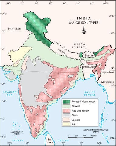
- Area figures vary widely with the map and the count. The table sets three counts side by side, so that older figures can still be read.
- The last column is the National Bureau’s 2013 mapping, in which alluvial soils are far smaller and red soils far larger than in the older counts.
| Group | Older ICAR-group count (lakh sq km; %) | Reporting-area count (million ha; %) | National Bureau 2013 (%) | Main USDA orders |
|---|---|---|---|---|
| Alluvial | 15; 45.6 | 143.1; 43.4 | 30.4, plus 3.1 coastal | Inceptisols, Entisols, Alfisols |
| Black | 5.46; 16.6 | 50; 15 | 16.6 | Vertisols, Inceptisols, Entisols |
| Red | 3.5; 10.6 | 61; 18.5 | 26.8 | Alfisols, Ultisols, Entisols, Inceptisols |
| Laterite | 2.48; about 7.5 | 12.2; 3.7 | 5.5 | Alfisols, Ultisols, Inceptisols |
| Forest and mountain | 2.85; 8.67 | 18.2; 5.5 | About 1 (hill, brown forest, tarai and others) | Inceptisols, Entisols, Mollisols |
| Arid and desert | 1.42; 4.32 | 15; about 4.5 | 8.0 | Aridisols, Inceptisols, Entisols |
| Saline and alkaline | 0.68; about 2 | Not separated | Spread through other groups | Not separated |
| Peaty and marshy | Not given | Not given | Under 0.1 | Not separated |
The USDA Soil Taxonomy Scheme
- ICAR has also classified Indian soils by their nature and character, under the United States Department of Agriculture (USDA) Soil Taxonomy.
- This system grew out of the USDA’s 7th Approximation (1960), and defines classes through measurable morphology and composition, not through colour or presumed origin.
- It reached Indian geography through the 1972 Irrigation Atlas of India.
- The eight classes used in India:
| Order | Area (thousand ha) | Share (%) |
|---|---|---|
| Inceptisols | 1,30,372.90 | 39.74 |
| Entisols | 92,131.71 | 28.08 |
| Alfisols | 44,448.68 | 13.55 |
| Vertisols | 27,960.00 | 8.52 |
| Aridisols | 14,069.00 | 4.28 |
| Ultisols | 8,250.00 | 2.51 |
| Mollisols | 1,320.00 | 0.40 |
| Others | 9,503.10 | 2.92 |
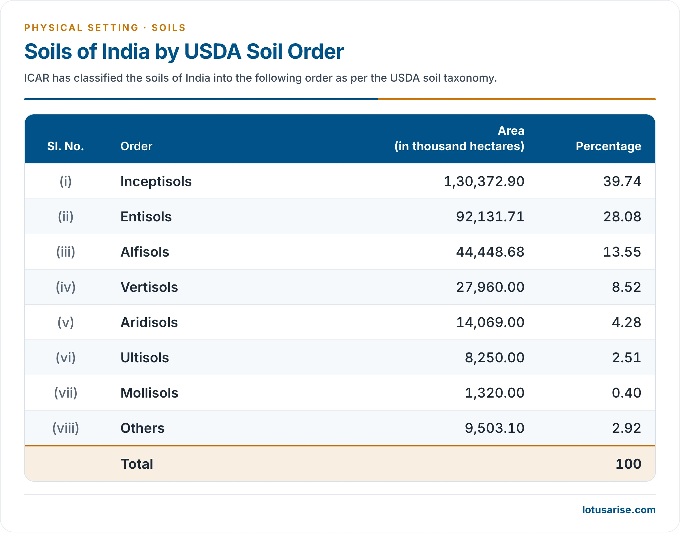
- Two points of current pedology:
- Inceptisols form a catch-all order, holding soils that fit nowhere else. Nearly 40% of India falls here, against about 15% of the world.
- Indian surveys report no true Oxisols, so India’s laterites do not map onto that order, despite their deep weathering.
The Eight Major Soil Groups
Alluvial Soils
- Origin: mainly silt laid down by the Indo-Gangetic-Brahmaputra rivers. Wave action forms some alluvial deposits in coastal regions.
- Parent material: rocks of the Himalaya supply most of it, so the material is of transported origin.
- Rivers carry the products of mountain weathering and drop them on low ground. Peninsular rivers do the same in their deltas.
- Extent: the largest group, at roughly 15 lakh sq km, which is about 46% (45.6%) of the land by the older count.
- Importance: the most productive farmland, supporting more than 40% of India’s population.
Characteristics of Alluvial Soils
- Immature, with weak profiles, because of their recent origin.
- Texture: most of the soil is sandy, though clayey soils are not uncommon.
- It runs from loamy to sandy loam in drier regions and clayey loam towards the delta.
- The full range spans drift sand, rich loam, silt and stiff clay.
- Pebbly and gravelly soils are rare. Kankar, or calcareous concretions, forms beds in some regions along the river terraces.
- Porous, because of its loamy nature. A loam is a balanced mix of sand, silt and clay, not equal parts of sand and clay alone.
- Porosity and texture give good drainage and other conditions that favour farming.
- Recurrent floods keep renewing them.
Chemical Properties of Alluvial Soils
- Nitrogen is generally low.
- Potash, phosphoric acid and alkalies are adequate.
- Iron oxide and lime differ greatly from place to place.
Distribution of Alluvial Soils in India
- All along the Indo-Gangetic-Brahmaputra plains, from Punjab to West Bengal and Assam, except in a few places where desert sand covers the top layer.
- In the deltas of the Mahanadi, Godavari, Krishna and Cauvery, as deltaic alluvium. Along the shore it is called coastal alluvium.
- In the Narmada and Tapi valleys and the northern parts of Gujarat.
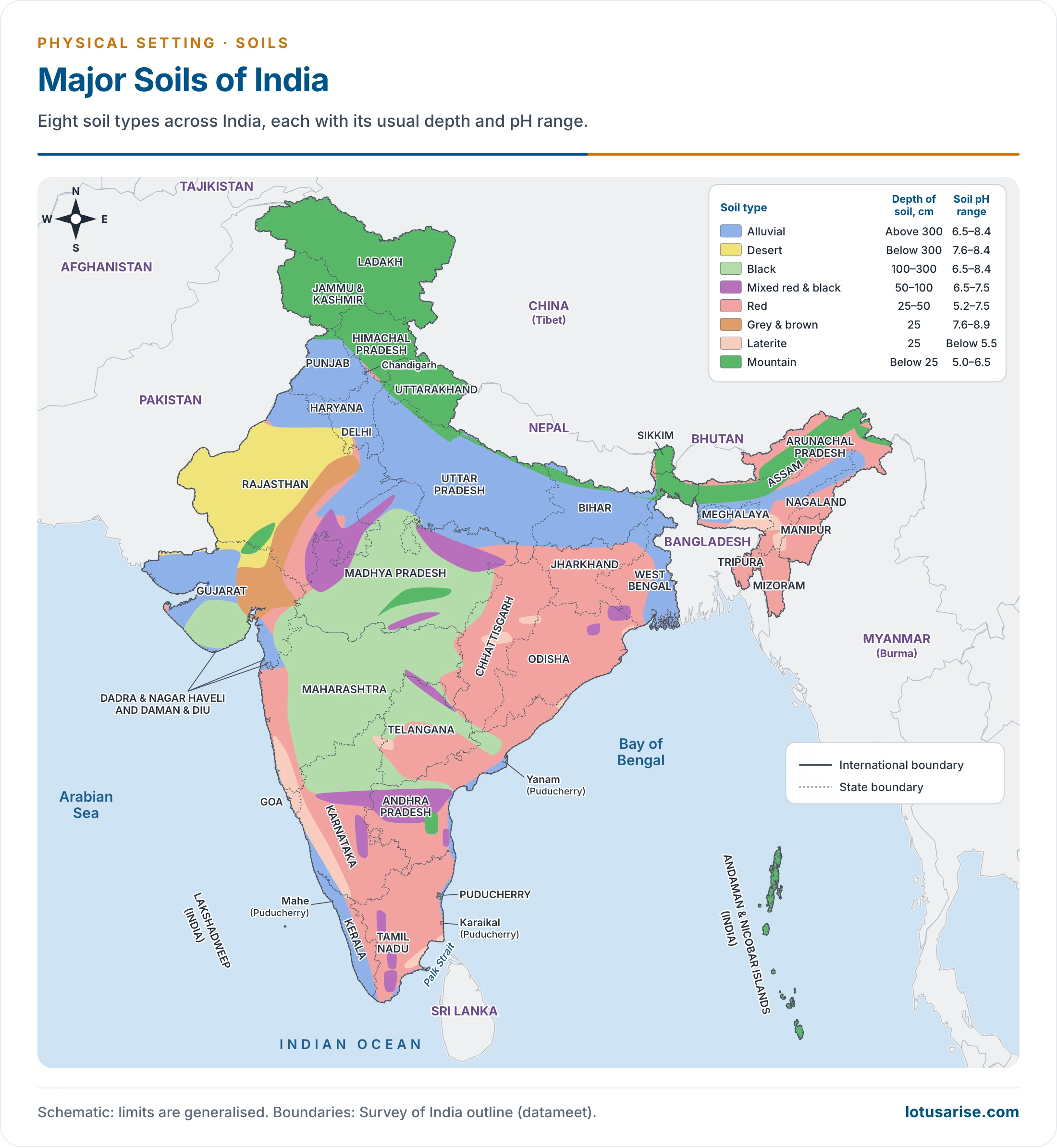
- On this map, the blue tract marks alluvium. The legend also gives each soil’s usual depth and pH.
Crops in Alluvial Soils
- The land is mostly flat and regular, and the best suited to farming.
- Being soft and fertile, these soils are the best suited to irrigation, and they respond well to canal and well or tube-well irrigation.
- Intensive rice in Punjab and Haryana shows how far irrigation can carry them.
- They yield rich harvests of rice, wheat, jute, sugarcane, cotton, tobacco, maize and oilseeds, plus fruit and vegetables.
- Rainfall sorts the crops across the alluvial regions:
| Annual rainfall | Suited to |
|---|---|
| Above 100 cm | Paddy |
| 50–100 cm | Wheat, sugarcane, tobacco, cotton |
| Below 50 cm | Coarse grains (millets) |
Geological Divisions of Alluvial Soils
- By age, the Great Plain’s alluvium splits into younger khadar and older bhangar. Two foothill belts, bhabar and terai, lie to their north. These belts are part of the Indo-Gangetic plain.
| Belt | Position | Soil | Land use |
|---|---|---|---|
| Bhabar | Along the Shiwalik foothills, 8–16 km wide | Coarse, pebbly, highly porous | Not suited to farming; only big trees with large roots |
| Terai | South of the bhabar, 15–30 km wide | Silty, swampy, rich in nitrogen and organic matter, low in phosphate | Tall grass and forest; crops once reclaimed |
| Bhangar | Terraces about 30 m above flood level | Older alluvium, more clayey, dark, kankar below | Wheat, rice, maize, sugarcane, pulses, oilseeds |
| Khadar | Flood plains along the river banks | Newer alluvium, sandy clays and loams, pale | The most fertile soils of the Ganga |
- Bhabar:
- The porous, northernmost stretch of the Indo-Gangetic plain, running along the Shiwalik foot.
- Himalayan rivers drop their load as alluvial fans, often of pebbly soil, and the merged fans build the belt.
- Porosity is its most distinctive feature, the result of huge amounts of pebbles and rock debris in the fans.
- Streams disappear on reaching it, so it shows dry courses except in the rainy season.
- Terai:
- An ill-drained, damp and thickly forested narrow tract, running parallel to the bhabar. It covers about 56,600 sq km.
- The underground streams of the bhabar re-emerge here, making a swampy lowland.
- Under reclaimed conditions it bears wheat, rice, sugarcane, jute and soyabean.
- The forest shelters a variety of wildlife.
- Bhangar:
- Older alluvium along the rivers, in terraces above the flood plain.
- A few metres down, lime nodules form beds of kankar.
- Khadar:
- The banks flood almost every year, and each flood leaves a new layer of alluvium.
- Its soils are drier and more leached, and less calcareous and carbonaceous (less kankary).
Black Soils
- Names: regur comes from Telugu reguda, and black cotton soil from the main crop. Internationally they are the tropical chernozems, and most fall in the order Vertisols.
- Formation: the weathering of basaltic rocks that poured out in fissure eruptions.
- The eruptions were Cretaceous. The Deccan Traps cluster at about 66 million years and the Rajmahal Traps at about 120–116 million years.
- Parent material:
- For most of these soils, the volcanic rocks of the Deccan and Rajmahal traps, which give sufficiently deep soil.
- In Tamil Nadu, gneisses and schists, which give generally shallow soil.
- Climate: a hot tract of low rainfall, so the group is typical of the dry Peninsula.
- Other views of origin:
- Norbert Krebs held regur to be a mature soil produced by relief and climate, not by one rock type. He placed it where rainfall is 50–80 cm, on 30–50 rainy days, and treated the wetter west Deccan as an exception.
- In parts of Gujarat and Tamil Nadu, it has been ascribed to old lagoons filled with material from the lava country inland.
- Extent: 15% of the area by one count and 16.6% by another.
Characteristics of Black Soils
- Highly argillaceous, which means clay-rich: a clay factor of 62% or more, with no gravel or coarse sand.
- Montmorillonite (smectite) dominates the clay, and this mineral explains both the swelling and the water storage.
- Fertility varies with position: upland black soils are of low fertility, while those of the valleys are darker, deeper and very fertile.
- It holds moisture very well. Wetting makes it swell strongly, and in the rains it turns so sticky that ploughing is very hard work.
- In summer it dries and contracts, opening deep cracks, often 10–15 cm wide and up to a metre deep.
- Lower layers stay moist, and the cracks let air reach deep into the soil.
- This underlies its long-praised fertility.
- Self-ploughing capacity: when dry, it breaks into a blocky structure, and loosened surface particles fall into the cracks, so the soil “swallows” itself.
- A kankar-rich layer lies at depth, especially over ferromagnesian schists.
Colour of Black Soils
- The classical explanation is traces of titaniferous magnetite, or iron and other dark minerals inherited from the basalt.
- Work on tropical black clays now points mainly to humus bound tightly to smectite clay. The colour bleaches when organic matter is destroyed, even though organic carbon rarely exceeds 1%.
- Crystalline schists and basic gneisses are credited with the colour in Tamil Nadu and parts of Andhra Pradesh.
- Tints include deep black, medium black and shallow black, and a mixture of red and black.
Chemical Composition of Black Soils
- Alumina: 10%.
- Iron oxide: 9–10%.
- Lime and magnesium carbonates: 6–8%.
- Potash: variable, less than 0.5%.
- Phosphates, nitrogen and humus: low.
- In short, the soil is rich in iron and lime but deficient in humus, nitrogen and phosphorus.
Distribution of Black Soils
- Chiefly the Deccan lava plateau, within about 15°–25°N and 72°–82°E.
- It spreads over 5.46 lakh sq km (16.6%) across Maharashtra, Madhya Pradesh, parts of Karnataka, Telangana, Andhra Pradesh, Gujarat and Tamil Nadu.
Crops in Black Soils
- Best suited to cotton, which gives the soil its popular name.
- Other major crops are jowar, wheat, millets, linseed, castor, sunflower and Virginia tobacco.
- Rice and sugarcane are equally important where irrigation is available.
- Vegetables and fruits also do well in large variety, including citrus.
- The soil has borne varied crops for centuries without fertilisers, manure or fallow, and with little sign of exhaustion.
- Its low nitrogen and phosphate mean high modern yields still need added nutrients.
Red Soil
- Origin: developed on Archaean granite, chiefly from ancient crystalline and metamorphic rock such as acid granites and gneisses.
- Extent: it holds the second largest area at 18.5%, about 61 million hectares. A narrower count gives 3.5 lakh sq km, or 10.6%, and the latest mapping gives 26.8%.
- Colour: thin coatings of ferric oxide on the particles make it red. The wide diffusion of iron matters more than a high iron percentage.
- The top layer is red and the horizon below yellowish, the yellow marking hydrated iron.
- Its shades run through brown, yellow, chocolate and grey, sometimes nearly to black.
- Texture: sandy to clayey and loamy, with loam the most common. Well drained and of sandy structure, it is porous and friable.
- The term is comprehensive, covering several minor types, so this soil is also known as the omnibus group.
Characteristics of Red Soils
- Highly variable rainfall has produced three subtypes:
| Subtype | Rainfall | Where | Note |
|---|---|---|---|
| Red and yellow soil | About 200 cm | North-East (Nagaland, Mizoram, Manipur hills), parts of the Malabar coast | Needs quick drainage |
| Red sandy soil | 40–60 cm | Drier plateaus: Karnataka, Tamil Nadu, Telangana, Rayalaseema | Thin and light |
| Red alluvial soil | Varies | Along river valleys | Good fertility |
- Position matters: on uplands the soil is thin, poor, gravelly and stony. In lower areas it is rich, deep, dark and fertile.
Chemical Composition of Red Soils
- Rich in iron and fairly rich in potash, but deficient in other minerals. Potash does vary, and some tracts run short of it.
- Generally deficient in phosphate, lime, magnesia, humus and nitrogen.
- Chiefly siliceous and aluminous, with free quartz as sand, and with little kankar or soluble salt. Leaching is a constant problem.
Distribution of Red Soils
- Mainly the Peninsula, between Tamil Nadu and Bundelkhand from south to north, and between Kathiawad and Rajmahal from west to east.
- It covers almost all of Tamil Nadu and parts of Karnataka, south-east Maharashtra, Telangana, Andhra Pradesh, Madhya Pradesh, Chhattisgarh, Odisha and Chota Nagpur.
- Further north and east: south Bihar; Birbhum and Bankura in West Bengal; Mirzapur, Jhansi, Banda and Hamirpur in Uttar Pradesh; the Aravallis and eastern Rajasthan; parts of Assam, Nagaland, Manipur, Mizoram, Tripura and Meghalaya.
Significance of Red Soils
- Once irrigated and given humus, it yields well, because the mineral base is rich. It responds strongly to fertilisers.
- It supports rice, sugarcane and cotton, along with wheat, tobacco, oilseeds, potatoes and fruit.
- Millets and pulses are grown in drier areas.
- The Kaveri and Vaigai basins are known for red alluvium, suited to paddy if well irrigated.
- Large tracts of Karnataka and Keralam carry rubber and coffee plantations.

Laterite Soil
Formation of Laterite Soil
- The name comes from the Latin later, meaning brick. Francis Buchanan gave it in 1807, describing a clayey material near Angadipuram in Malabar that was cut soft and then hardened on exposure.
- Dates of 1810 and 1905 are also found in print, but 1807 is the date of his published account.
- Modern study of that very site identifies the material as the hardened mottled zone of a deep weathering profile.
- Two conditions matter:
- A laterite weathering cover, rich in iron and aluminium. The rock is the end product of weathering, not an original bedrock, and it can form over granite, basalt and other parent rocks.
- Alternating wet and dry periods, with high temperature and heavy rainfall, which suit it best.
- Mechanism: rain leaches away lime and silica, leaving a residue rich in oxides of iron and aluminium.
- Views on the term:
- Lewis Leigh Fermor restricted it to material with 90–100% oxides of iron, aluminium, titanium and manganese.
- Boris Polynov saw laterite as the end product of weathering, given enough time.
- George Kuriyan linked it to rainfall above 200 cm, and described a range from bauxite at one end to mixed ferric oxides at the other.
Characteristics of Laterite Soil
- Reddish-brown in colour, and made up essentially of a mixture of hydrated oxides of aluminium and iron.
- Iron oxides occur in nodular form.
- Iron and aluminium abound, while nitrogen, phosphorus, potash, lime and magnesia run short.
- Phosphate can be locally high, probably as iron phosphate.
- Humus and water retention are moderate at best. Bacteria are very active in the heat, and heavy rain leaches the rest, so humus usually runs moderate to low, though some places hold more.
- Low base-exchange capacity keeps typical laterite poor for crops without inputs.
- It has unique value as building stone: it can be cut with a spade, hardens like iron in air, and, being fully weathered, lasts indefinitely.
Distribution of Laterite Soil
- About 2.48 lakh sq km. Regions include:
- Patches in the Western Ghats, especially Goa and Maharashtra, on summits at 1,000–1,500 m.
- Belagavi (Belgaum) district of Karnataka and the laterite plateau of Keralam.
- Odisha and the Eastern Ghats.
- The Amarkantak plateau of Madhya Pradesh.
- Panchmahal district of Gujarat.
- Santhal Pargana division of Jharkhand.
- Also the Rajmahal hills, Vindhyas, Satpuras and Malwa plateau, with good development in Andhra Pradesh, Telangana, West Bengal, Assam (North Cachar) and Meghalaya (Garo Hills). Some lies lower down, in valleys.
Significance of Laterite Soil
- Noted for groundnut and cashew nut, along with ragi, and sugarcane where watered.
- In Karnataka it is given over to coffee, rubber and spices.
- Manured and irrigated, it also bears tea, cinchona, coconut and arecanut, with paddy in low-lying areas.
- Parts of Keralam, Karnataka, Chota Nagpur, Odisha and Assam respond well to nitrogen, phosphorus and potassium.
- Elsewhere it supports grazing grounds and scrub forest.

Forest Soil or Mountain Soil
- Formation: found principally on mountains with steep slopes, high relief and shallow profiles, under forest cover.
- Organic matter from the forest largely decides its character.
- It is heterogeneous, changing with rock, ground form and climate, so soils only a short way apart may differ greatly.
- Characteristics:
- Thin layered, with poorly developed profiles and horizons, and immature.
- Fast drainage leaves it open to soil erosion.
- Rich in organic content, with adequate humus, but deficient in potash, phosphorus, lime and other nutrients. Yields therefore need plenty of fertiliser.
- A loamy soil, where sand, silt and clay are mixed. Silt loam to loam is common, and it is dark brown.
- Acidic in the cold upper belts, as noted under climate.
- Types in the Himalaya:
- Loamy podzols: acidic, low in humus, under deodar and pine in the middle zone, from Jammu and Kashmir to Assam.
- High-altitude soils: brown earths and red loams, with a subsoil frozen under snow.
- Distribution:
- Generally above 900 m. Area about 2.85 lakh sq km (8.67%).
- The Himalaya and its foothills, and the mountain slopes of the Western Ghats, Nilgiri, Annamalai and Cardamom hills. Also the Eastern Ghats and parts of the Peninsular plateau.
- In the Himalaya it favours valley basins and gentler slopes. North-facing slopes generally hold soil, while steep south-facing ones are too exposed to keep it.
- Significance:
- It helps crops that need free air and water drainage, which the slope provides.
- Used for rubber and bamboo plantations, along with tea, coffee, spices and fruit.
- Used for wheat, maize, barley and temperate fruit in Jammu and Kashmir, Himachal Pradesh and Uttarakhand.
- Large areas go to shifting agriculture, where fertility falls after 2–3 years.
- With limited scope for farming, silvi-pastoral use (forest plus grasses) can be sustained.

- This high slope of moraine and scree shows why soils at the upper limit stay thin and patchy.
Desert Soil
- Origin: deposited by wind action, mainly in arid and semi-arid areas with under 50 cm of rain. The sand comes from rock disintegration, or south-west winds carry it from the coast and the Indus basin.
- Where: Rajasthan west of the Aravallis, northern Gujarat, Saurashtra, Kachchh, western Haryana and southern Punjab.
- It occurs mainly in western Rajasthan and the Rann of Kachchh, and in patches in south Haryana and south Punjab.
- Area about 1.42 lakh sq km (4.32%). The mapping of 2013 gives a wider 8%.
- Barren sandy soils with no clay also occur on the coasts of Odisha, Tamil Nadu and Keralam.
- Texture: sandy, with 90–95% aeolian sand and 5–10% clay, and low in organic matter.
- Moisture and life: lacking in moisture, with very low retaining capacity. Humus is scant, and so are living microorganisms.
- Chemistry:
- Nitrogen is originally low, though some is available as nitrates.
- Phosphorus is nearly adequate, close to that of normal alluvium.
- Rich in iron, lime and bases. Calcium increases downward, and some subsoils hold ten times the surface level.
- Soluble salts vary. Some tracts are low in them, but many contain a high percentage, and these soils are often alkaline.
- Use:
- If irrigated, it gives a high return, as the phosphates and nitrates are already there. The Indira Gandhi Canal command has transformed cropping in western Rajasthan.
- Suited to less water-intensive crops: bajra, pulses, fodder and guar.
- Without water, only drought-resistant and salt-tolerant crops grow, such as wheat, barley, millets, maize, rape and cotton, so population stays thin.
- Land development in these tracts is taken up under the Desert Development Programme.

Saline and Alkaline Soil
- Two chemical kinds occur, often together.
- Saline soils carry sodium, calcium and magnesium salts in chloride and sulphate form, chiefly sodium chloride and sodium sulphate.
- Alkali soils are dominated by sodium salts, especially sodium carbonate. The plain statement that alkali soil holds much NaCl fits saline soil, not alkali soil.
- The soil is infertile until reclaimed.
- Local names: reh, usar, kallar, rakar, thur, karl and chopan.
- Where: mainly Rajasthan, Haryana, Punjab, Uttar Pradesh, Bihar and Maharashtra, along with Andhra Pradesh, Telangana and Karnataka.
- Formation and distribution: both natural and anthropogenic.
- Natural:
- The dried-up lakes of Rajasthan and the Rann of Kachchh.
- The playa basin, a clay basin in the midst of the desert.
- Rock fragments that release sodium, magnesium and calcium salts as they weather. Rivers then carry these salts into the subsoil of the plains.
- Sea tides around the Gulf of Khambhat, affecting the estuaries of the Narmada, Tapi, Mahi and Sabarmati.
- Anthropogenic:
- Developed in western Uttar Pradesh and Punjab through faulty farming.
- Over-irrigation raises the water table, and capillary action brings salts to the surface in the dry season as a white crust.
- Other cases are the karl soils of Dharwad and Bijapur, and the salt lands of the Nira valley on black soil.
- Natural:
- Characteristics: short of moisture, humus and living microorganisms, so humus formation almost stops. Sandy to sandy-loam, with low nitrogen and calcium.
- Use: once treated, it suits leguminous crops such as berseem and dhaincha.
Peaty and Marshy Soil, or Bog Soil
- Origin: arises where adequate drainage is not possible, in humid regions where large amounts of organic matter accumulate.
- Nature: rich in organic matter (10–40%) with high salinity, but deficient in potash and phosphate. Peat is black, dense and strongly acidic.
- Characteristics:
- Clay and mud dominate, which makes it heavy.
- Rich in moisture. More salt, along with daily inundation by high tide, makes the coastal kind infertile.
- Biological activity is held back by excess water, and for that reason organic matter piles up instead of decaying.
- Distribution: characteristic of the delta regions of India, including the Sundarbans and the Mahanadi, Godavari, Krishna and Kaveri deltas.
- Besides the deltas, it occurs at Alappuzha (Alleppey) and Kottayam in Keralam, where it is known as kari along the backwaters or kayals.
- It also occurs in Almora (Uttarakhand), north Bihar and the coasts of Odisha and Tamil Nadu.
- Significance:
- In the Bengal delta, it suits jute and rice. In Malabar, it suits spices, rubber and big-sized rice.
- Most of it stays under water in the rains and goes under paddy once they end.
- To some extent it favours India’s mangrove forests.

The Groups Compared
| Soil | Origin | Rich in | Poor in | Typical crops |
|---|---|---|---|---|
| Alluvial | River and wave deposits | Potash, phosphoric acid | Nitrogen | Rice, wheat, sugarcane, jute |
| Black | Basalt, some gneiss | Iron, lime, alumina | Nitrogen, phosphorus, humus | Cotton, jowar, wheat |
| Red | Granite, gneiss | Iron, some potash | Lime, nitrogen, phosphate | Millets, pulses, rice |
| Laterite | Deep leaching | Iron, aluminium | Nitrogen, potash, lime | Cashew, tea, coffee |
| Forest | Forest humus on slopes | Humus | Potash, phosphorus, lime | Tea, spices, fruit |
| Desert | Wind-blown sand | Lime, bases, phosphate | Nitrogen, humus, moisture | Bajra, guar, pulses |
| Saline, alkaline | Salts, over-irrigation | Sodium salts | Nitrogen, calcium | Berseem after treatment |
| Peaty, marshy | Poor drainage | Organic matter, salts | Potash, phosphate | Rice, jute |
Smaller Classes
- Some schemes split the groups further:
- Red and black soils: isolated patches over granite, gneiss and quartzite in Bundelkhand and east of the Aravallis. Poor without irrigation, they bear maize, bajra and pulses.
- Grey and brown soils: loose and friable, in Rajasthan and Gujarat.
- Sub-montane soils: in the terai belt from Jammu and Kashmir to Assam, fertile under forest but easily eroded once cleared.
- Karewa soils: on the lake deposits of the Kashmir valley and Bhadarwah, noted for saffron and orchards.
- Snowfields: a mapped class of the high ranges.
Characteristics and Problems of Indian Soils
Characteristics of Indian Soils
- Varied origin: they formed under very different conditions, so they differ widely in physical properties, chemistry and fertility.
- Most soils are old and mature. Peninsular plateau soils long predate those of the Great Northern Plain.
- Commonly short of nitrogen, humus, mineral salts and organic matter.
- Depth: plains and valleys have thick layers, while hills and plateaus have a thin cover.
- Fertility is uneven: alluvial and black soils rank high, and laterite, desert and alkaline soils give poor harvests.
- Long cultivation: hundreds of years of cropping have cost them much of their fertility, so they need scientific care.
- Seasonal rain means they need irrigation in the dry months.
- They suffer from erosion and allied problems.
Problems of Indian Soils
- The main problems, with their usual settings:
| Problem | Typical area |
|---|---|
| Soil erosion | Himalayan region, Chambal ravines |
| Deficiency in fertility | Red, lateritic and other soils |
| Desertification | Around the Thar; rain-shadow parts of Karnataka, Telangana |
| Waterlogging | Punjab–Haryana plain |
| Salinity and alkalinity | Over-irrigated parts of Punjab, Haryana, Karnataka |
| Wasteland | Spread across the country |
| Overexploitation | Wherever population and living standards rise |
| Encroachment on farmland | Around growing towns and transport routes |
- Current national picture: the Desertification and Land Degradation Atlas of the Space Applications Centre (2021) puts land under degradation at 97.85 million hectares (29.77%) in 2018–19.
- This compares with 94.53 million hectares (28.76%) in 2003–05 and 96.40 million hectares (29.32%) in 2011–13.
- Main drivers: water erosion (11.01% of the land), vegetation degradation (9.15%) and wind erosion (5.46%).
- Nine areas hold 80% of it: Rajasthan, Maharashtra, Gujarat, Ladakh, Karnataka, Jharkhand, Odisha, Madhya Pradesh and Telangana.
- India has pledged to restore 26 million hectares by 2030.
- A separate harmonised ICAR estimate (2010) gives about 120.4 million hectares degraded: water erosion 82.6, wind erosion 12.0, chemical degradation 24.8, physical degradation 1.0.
Soil Erosion
- Soil erosion removes soil faster than natural processes can replace it.
- Scale:
- An old estimate puts over 80 million hectares, about a quarter of the country, at risk, with half of it seriously eroded.
- India loses about 5.3 billion tonnes of soil a year, or 16.35 tonnes per hectare. About 29% reaches the sea, 10% settles in reservoirs and 61% is shifted to other places.
- The permissible rate is far lower, at about 4.5–11.2 tonnes per hectare.
- Water erosion: strongest in the mountains, hills and upper piedmont.
- Splash: raindrops, falling at about 10 m per second, detach sand and silt.
- Sheet erosion: a whole top layer goes, often on steeper, rain-soaked slopes. It is the more insidious, because it takes the best soil first.
- Rill erosion: finger-like grooves form, branching like a tree.
- Gully erosion: rills deepen into gullies, and the land may turn into badland.
- Ravines: gullies with a sudden drop of 3–4 m that flatten out, reaching 30 m or more in depth.
- Other agents:
- Sea erosion works along the coast, as on Keralam’s sandy beaches, where coconut trees are uprooted.
- Glacial erosion works in the high Himalaya.
- Chos, seasonal streams from the Shiwaliks, cut up the Hoshiarpur tract of Punjab.
- Wind erosion: works on dry, loose and bare soil in the arid north-west.
- Fine particles travel in suspension, sand in saltation, and coarse grains by surface creep.
- Very coarse fragments stay behind as desert pavement.
- Ravine land: a working group of 1971 counted 39.75 lakh hectares in 18 States. Of this, 27.65 lakh hectares (69.55%) lay in four States:
| State | Ravines (lakh hectares) |
|---|---|
| Uttar Pradesh | 12.30 |
| Madhya Pradesh | 6.83 |
| Rajasthan | 4.52 |
| Gujarat | 4.00 |
| Punjab | 1.20 |
| West Bengal | 1.04 |
| Bihar, Tamil Nadu | 0.60 each |
| Maharashtra | 0.20 |
- Human causes:
- Deforestation: roots no longer bind the soil or regulate water, as in the Shiwaliks and the Chambal ravines. Cutting trees in a river’s upper reaches raises both floods and erosion.
- Overgrazing: in long dry spells, grass is torn out, and hooves pulverise the surface. It is common in the western Himalaya and in the dry parts of Rajasthan and the Deccan.
- Faulty farming: ploughing along the slope, growing one crop year after year, and shifting cultivation.
- Shifting cultivation is strongest in the North-East and Odisha, on a cycle once of 10–15 years and now often about five.
- Potato on steep Nilgiri slopes has cut yields by about half.
- Works: diverted drainage and badly aligned roads, railways, embankments and bridges.
- Effects:
- Loss of fertile topsoil and nutrients, and a fall in farm output.
- Lower water tables and less soil moisture, with drying vegetation and spreading aridity.
- More frequent floods, droughts and landslides.
- Silting of rivers, canals and tanks, with a wider cost to the economy.
Soil Salinity and Alkalinity
- Cause: chiefly over-irrigation in canal commands, which lifts the water table and draws salts upward.
- Sandy soils lean to alkalinity, and loamy soils to a mix of salinity and alkalinity.
- Extent:
- An older estimate gives about 80 lakh hectares (2.43%).
- ICAR’s Central Soil Salinity Research Institute now maps about 6.73 million hectares: 3.77 alkali and 2.96 saline.
- Uttar Pradesh leads in alkali land (1.35 million hectares) and Gujarat in saline land (1.68).
- About 2.1 million hectares have been reclaimed.
- Yearly crop losses were put at about 17 million tonnes in 2015.
| State | Older count (lakh ha) | Current mapping (lakh ha) |
|---|---|---|
| Uttar Pradesh | 12.95 | 13.69 |
| Gujarat | 12.14 | 22.22 |
| Punjab | 12.25 | 1.52 |
| West Bengal | 8.50 | 4.41 |
| Rajasthan | 7.28 | 3.75 |
| Maharashtra | 5.34 | 6.07 |
| Haryana | 5.26 | 2.33 |
| Tamil Nadu | 0.04 | 3.68 |
- The two counts used different methods, so a gap between them does not by itself measure change.
- Effects:
- Falling fertility and failed crops, a limited choice of crops, and poor fodder.
- Damage to buildings and roads, along with floods from reduced infiltration.
- The Indira Gandhi Canal, despite its gains, has brought salinity to parts of Rajasthan.
- Treatment:
- Drainage, canal lining and careful water use.
- Salt-tolerant crops: barley, rape, cotton and date palm.
- Rotations with dhaincha: with cotton in the Deccan, with rice in Uttar Pradesh, and with rice and berseem in Punjab and Haryana.
- Gypsum in the top 15 cm, or sulphur and pyrite, with rice husk and straw. Cow dung also helps.
- Flushing with water, though this can move saline water downstream.
Desertification
- Desertification is the spread of desert-like conditions in dry lands, through human action or climatic change.
- Dryland base:
- India’s drylands span about 228 million hectares, of which 83.69 million hectares are under desertification (2021 atlas).
- An older count classes 12.13% of the country as arid and 29.13% as semi-arid.
| State | Arid (%) | Semi-arid (%) |
|---|---|---|
| Rajasthan | 57.42 | 36.67 |
| Gujarat | 33.72 | 47.50 |
| Jammu and Kashmir, with Ladakh (older count) | 31.13 | 6.22 |
| Haryana | 29.32 | 59.77 |
| Punjab | 24.60 | 75.40 |
| Karnataka | 4.27 | 72.60 |
| Maharashtra | 0.42 | 61.17 |
- Why these areas:
- Distance from the sea dries the north-west.
- The Western Ghats rain shadow dries Karnataka, Telangana, Andhra Pradesh, Tamil Nadu and Maharashtra.
- Ladakh is a cold desert, with annual precipitation hardly above 20 cm.
- Causes: uncontrolled grazing, reckless felling, growing population and climate change.
- Effects:
- Sand drift on farmland, and silting of water bodies.
- Falling water tables and more droughts.
- Wider wastelands and lower harvests.
- Is the Thar advancing?
- A popular figure says it marches about 0.5 km a year. The First Five-Year Plan gave a similar one, about half a mile.
- Rainfall, water balance, land-use and geomorphic studies do not support a systematic eastward march.
- Local degradation by misuse is the real concern, and stabilisation has cut the dune area by about 12% since 1980.
- Measures:
- Plantation, along with control of grazing and of felling, and new pastures.
- Mulching of shifting dunes in Bikaner, Churu, Barmer, Jhunjhunu and Jaisalmer, laid in squares as devised at the Central Arid Zone Research Institute, Jodhpur.
- Other fuel sources, and planned use of sandy land.
Waterlogging
- Meaning: the water table rises until soil pores in the root zone are saturated, cutting off air to the roots.
- Causes:
- Flat land and saucer-like hollows that hold rain.
- Canal seepage, poor on-farm water use and lack of drainage.
- Blocked natural drains, cropping in drainage channels, and cyclonic or tidal flooding on the coast.
- Extent: an older estimate gives about 12 million hectares, half on the coast and half in irrigation commands. The 2021 atlas maps it as a process on 0.25% of the land.
- Link: it is among the chief causes of salinity.
- Remedies:
- Surface drainage: open drains with a proper outlet, for deep, slowly absorbing soils on level land with intense rain.
- Vertical drainage: wells and bores that lift groundwater. Tube-well pumping has reclaimed waterlogged saline land in the Punjab–Haryana plain.
- Canal lining, as along the Indira Gandhi Canal.
Soil Conservation
- Soil conservation protects soil from erosion and exhaustion. About two-thirds of India’s arable land needs such measures, by one estimate.
- Afforestation:
- The long-standing goal is a forest cover of one-third of the land, classically 20% in the plains and 60% in the hills. An earlier yardstick for soil and water safety was 20–25%.
- The National Forest Policy, 1988 keeps the one-third goal and aims at two-thirds in the hills.
- Social forestry along canals, roads and railways helps too.
- Grazing and dams: set aside grazing grounds and grow fodder. Dams slow floodwater, and small dams in upper reaches help most.
- Better farming practice:
| Method | How it works |
|---|---|
| Crop rotation | Alternates demands on the soil; legumes add nitrates. Maize, cotton, tobacco and potato promote erosion, and grass and legumes resist it |
| Strip cropping | Alternate strips of crops and fallow keep ground covered; tall crops act as windbreaks |
| Early-maturing varieties | Less time in the field means less pressure on the soil |
| Contour ploughing | Ridges across the slope break the flow of water |
| Terracing and contour bunding | Divide a slope into smaller ones; bunding loses value above 8% slope, terracing above 20% |
| Ploughing across the wind | Cuts wind speed at the surface |
| Settled farming | Replaces shifting cultivation with resettlement support |
- Reclaiming bad land: plugging gully mouths, bunding, levelling and tree planting, with restored long fallow brought back under crops, grass or orchards.
- Results and schemes:
- Yields: contour bunding raised yields by about 25% in several States. Bunding and levelling raised them by 35% and 60% in semi-arid Uttar Pradesh, and bench terracing lifted Nilgiri potato by 15–65%.
- River valley catchments: a programme for river valley and flood-prone catchments covers 53 catchments in 27 States.
- Alkali soils: a reclamation scheme began in Haryana, Punjab and Uttar Pradesh, and was later extended.
- Ravines: a reclamation programme began in 1987–88, using peripheral bunds, afforestation and rehabilitation.
- Shifting cultivation: a control scheme began in the North-East, Odisha and Andhra Pradesh in the 1980s.
- Soil Health Card: launched on 19 February 2015 at Suratgarh, Rajasthan, it reports 12 soil parameters to the farmer, with 25.17 crore cards issued by July 2025. It now runs under the Rashtriya Krishi Vikas Yojana.
- Remote sensing now helps the national soil survey keep watch on these changes.
Previous Year Questions
2026Deforestation in the upper reaches of a river augments the magnitude of soil erosion. Elaborate your answer citing the example of any North Indian river.2025What are the causes and consequences of land degradation due to desertification in India? Examine with reference to various regional issues.2022Soils of India are clear reflections of structure and process. Comment.2022The process of desertification leads to soil desiccation and soil loss. Explain.2021Discuss the economic significance of the volcanic soils of India.2020Soil types in India, classified on the basis of colour, possess specific chemical and mineral characteristics. Discuss.2017Justify the inclusion of Meghalaya in Peninsular India and discuss its vegetation and soil types.2016Describe the distribution of black soils in India and their specific use for agriculture.2015How does natural vegetation affect the formation of in situ soils?2014Bring out the distribution of laterite soils in India and their specific use for agriculture.2011Identify the ravine-affected areas in India and discuss the environmental and economic impacts of their reclamation.2010Write about the Spatial pattern of soil erosion in India.2009Discuss the formation and their distribution of the major soil types of India.1995Examine the origin and characteristics of the soils of the North Indian Plain.1992Explain the characteristics and productivity of the ‘Regur’ black soils of India.1989Explain the causes of soil erosion occurring over extensive areas in certain parts of India. What measures would you suggest for solving this problem?





 History Optional Mains Master Kit 2027 Complete Self-Study System — Notes, Mapping & Premium Articles by LotusArise IAS
 History Optional PYQ Master Pack: Topic-wise Model Answers (1985–2025) by LotusArise IAS
 Sociology Optional Mains Master Kit 2027 — Complete Self-Study System: Notes, Thinkers & Premium Articles by LotusArise IAS
Sir how to download pdf…..
Kindly help sir…
You can copy-paste in your OneNote/Word.
I want history notes also please upload history .
Working on it
You people are doing great works. Please keep uploading. God bless you
Thanks, Rickta for your kind words.
so enriched content on soil classification
Such an elaborated and enhanced description is something we commonly find missing even in the notes of reputed coaching. Great work sir!
Thanks
thank you
Very nice.. Nd one thing i must tell u.. I know u.. We had talked in telegram once.. When u send me the link of lotus. ..keep it up.. I wish i could make it in pdf nd print it
Thank you Lotus Arise…
You gave all important information at one place,Cover each and every topic with its 360°dimension…I covered almost all geography topics from your source only….I assured you that in recent future Lotus Arise will be king of Civil service in India
Very informative
very good
Thanks
very good content.thank u
ohh beautiful article.. you dnt have to go anywhere …. everything beautifully mention ….great …. it save my time ..thanks
Doing great work, thanks
who was done first detailed and scientific soil classification of maharashtra in 1938..
option ! A) dr kellogg and dr thorp
B)dr Basu and dr sirur
Thank you so much for the comprehensive content
I am from kashmir ..this is one of the most helpful site ever
Kudos to the team
This was pretty wholesome! 👌🏻
i bow down to your selfless service, let your generations be happy
Please add more about the importance of the soils as UPSC had asked many questions on importance in past ..it would be of great help thank you…keep up the great work that you are doing
No they haven’t
3 qns in last 12 yrs … And those regarding location and characteristics mainly
sir do u have any idea of releasing book in geography ?
If more people will request, then I will think about this.
Please do sir.
I never saw such a compounded material ever sir . Please do upload all subjects. Thank you so much sir ☺️☺️☺️
esa content kisi bhi jo ias k naam se channel chala rhe he kahi nhi milega….mne world geography and indian geography isi se cover kr rha hu or pichle 1 saal se follow kr rha hu.
sar jhuka ke pranam aapko…..
Thanks for your kinds words, Keep Reading.
Can not explain enough how helpful these notes are! Fine work. Thank you so much.
Dear Sir
I Can’t explain it in words, How dearly you are helping us..
Your content is really indispensable and easy to learn and revisable..
Keep Going Sir..📚
And Thanks for you unconditional support ♥️
such a complete and in an elaborated form.. very helpful !!
Guru dev apke me apke charan sparsh me🙏
black soil is spread over 5.46 lakh Sq km not 46 lakh
Sir please provide topic wise pyqs for geography and other subjects too…….and thank u for such an amazing content 🙏
no words to thankyou guys team lotusarise the accuracy and efficiency in your content is unbeatable thankyou for posting such a nice content
Am impressed ♡♡♡♡♡♡♡♡thankuuuuu
super content
Black soil spread over an area of 5 lakh sq km.. correct this one..your content is best