

1. Soil in the Biogeographical Frame

Soil is the thin, living skin of the continents — rarely more than two or three metres deep, yet it is the single medium in which climate, parent rock, relief, organisms and time are continuously translated into the vegetation cover, and hence the biogeography, of a region. Savindra Singh calls soil “the point of contact between the lithosphere and biosphere,” and it is precisely this mediating position that makes soil classification a recurring theme in the UPSC Geography Optional syllabus — it sits at the intersection of Physical Geography (weathering, pedogenesis) and Biogeography (zonal vegetation, biomes, ecosystem productivity).
Classifying something as heterogeneous as “soil” is inherently difficult. No scheme can be simultaneously genetic (explaining why a soil formed as it did) and morphological (describing precisely what a soil looks like in the field) without some loss of either explanatory power or descriptive precision. This article works through both traditions in the sequence UPSC most often expects: first the classical zonal–intrazonal–azonal system that dominates Indian geography textbooks, then the modern USDA Soil Taxonomy that has become the international scientific standard, and finally the practical question examiners keep returning to — where, in actual geographic space, each soil type occurs, and what that means for agriculture and land use.
2. Two Approaches to Classifying Soil
Achieving a classification of soils that is both meaningful to a geographer and an accurate reflection of the enormous variety of soil types on Earth is genuinely difficult, because soils vary continuously across space rather than falling into neat, discrete boxes. In practice, two broad philosophies have dominated the literature:
Genetic classification
- Groups soils by their assumed mode of origin — the climate–vegetation combination believed responsible for a soil’s character. This is the logic behind the zonal system pioneered by Russian pedologists Vasily Dokuchaev and Konstantin Glinka in the late nineteenth and early twentieth centuries.
Morphological classification
- Groups soils by observable, measurable properties of the profile itself — horizon sequence, colour, texture, base status, diagnostic layers — without presupposing an origin. This is the philosophy behind the USDA Soil Taxonomy adopted internationally since the 1960s–70s.
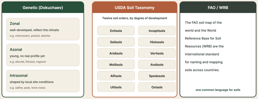
Both approaches remain live in Indian classrooms: the zonal system is the traditional vehicle for teaching soil–climate–vegetation correspondence (and therefore the natural bridge into biogeography), while USDA taxonomy is the scheme actually used today by soil scientists, including India’s own National Bureau of Soil Survey and Land Use Planning (NBSS&LUP), for mapping and land-capability classification.
3. Reading a Soil Profile
Before any classification can be understood, it helps to fix the vocabulary of the soil profile — the vertical section exposed when a pit is dug from the surface down to unweathered rock. A well-developed (mature) soil profile typically displays a sequence of horizons, each formed by distinct combinations of addition, removal, translocation and transformation of material:
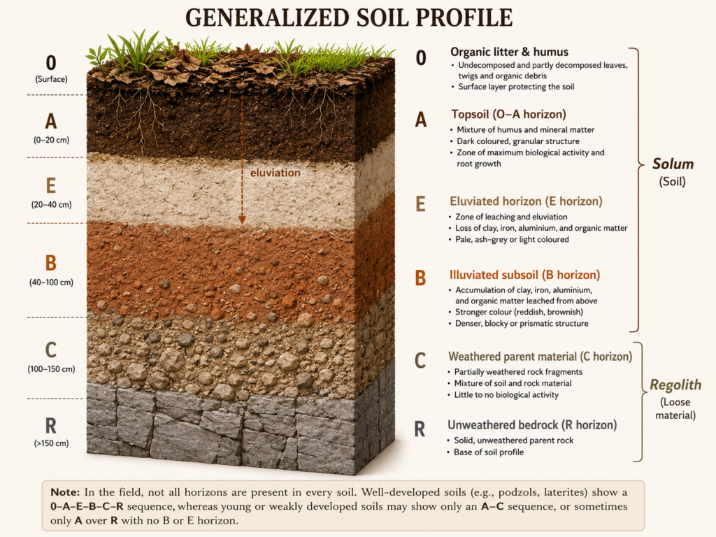
Two organising ideas run through every horizon description examiners expect:
- Organic vs mineral horizons: the O horizon (and, in some schemes, the upper A horizon) is dominated by organic litter and humus; the E, B, C and R horizons are progressively mineral, reflecting decreasing biological influence and increasing dominance of parent-material weathering with depth.
- Eluviation vs illuviation: eluviation is the washing-out of soluble salts, clays, and sesquioxides from an upper horizon (typically E); illuviation is their re-deposition at depth (typically B). This single pair of processes explains the bleached E horizon of a podzol and the iron/clay-enriched B horizon beneath it.
4. The Zonal System (Dokuchaev–Glinka)
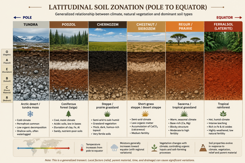
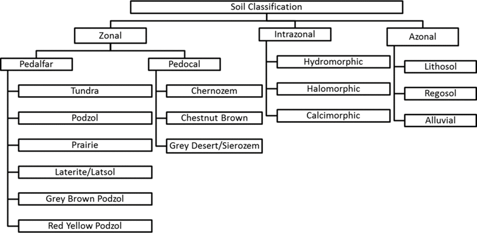
The zonal system is one of the oldest and most pedagogically influential classifications of soil. It was proposed by the Russian pedologists V. V. Dokuchaev and K. D. Glinka, who identified a strong, recurring relationship between climate, natural vegetation, and soil character across broad latitudinal belts of the Earth — precisely the correspondence that makes this topic properly “biogeographical” rather than purely edaphic. The system recognises three classes:
- Zonal soils — well-developed, mature soils whose character is dictated primarily by regional climate and vegetation, largely independent of local parent rock.
- Intrazonal soils — also well-developed and mature, but shaped by a dominant local factor (poor drainage, calcareous parent rock, salinity) that overrides the regional climatic signature.
- Azonal soils — immature, poorly developed soils lacking a distinct profile, typically because insufficient time has passed for horizon differentiation, or because a steep slope continually strips material as fast as it weathers.
1. Podzols (“ash-soils”)
Podzols form under the cool, moist climates immediately south of the tundra, characteristically beneath coniferous (taiga) forest. The dominant process is cheluviation — the chemical complexing and downward movement of iron, aluminium and humus by organic acids released from conifer needle litter. This produces the podzol’s diagnostic feature: a bleached, ash-grey E horizon stripped of iron and clay, sitting above an enriched B horizon. Three variants are recognised depending on what has concentrated in the B horizon:
- Humus podzol — humus itself is washed down and accumulates as a dark, humus-enriched B horizon.
- Iron podzol — iron oxide concentrates strongly at the B horizon, giving a rust-coloured band.
- Gley podzol — iron cements into a hard iron-pan, impeding drainage and producing waterlogged (gleyed) conditions above it.
Podzols are strongly acidic and naturally infertile, requiring liming and heavy fertiliser input for productive agriculture; they correspond closely to the Spodosols order of USDA taxonomy (Section 8).
2. Brown Earths
Found equatorward of the main podzol belt, under milder climates supporting deciduous forest. Leaching still occurs but is far less intense than in podzols. Free calcium carbonate is absent from the upper profile, yet sesquioxides (iron/aluminium oxides) are not sharply segregated into a distinct pale horizon — instead they remain dispersed throughout, giving the soil its characteristic overall brown colour. Humus is comparatively well distributed and less acidic than in podzols. Brown earths dominate lowland Britain and much of temperate Western Europe, corresponding broadly to Alfisols/Udalfs in USDA terms.
3. Tundra Soils
Tundra soils are governed above all by ground ice and permafrost, which produce complex patterning through freeze–thaw churning (cryoturbation). Where slopes are stable, slow organic decomposition (owing to cold and waterlogging) leaves a peaty surface layer. Where slopes are unstable through solifluction (the slow, saturated downslope creep of thawed surface material over frozen ground beneath), soils remain thin and poorly developed. In the most extreme, vegetation-free settings — such as the brown polar desert soils of Antarctica — soils are essentially humic-poor mineral skeletons. By contrast, the birch-forested tundra margins of the northern hemisphere develop Arctic brown forest soils, marked by a thick, dark organic A horizon. In USDA terms, tundra and permafrost-affected soils correspond to Gelisols.
Solifluction
A 2025 short-note question asked directly, “What is solifluction? What are its impacts?”
Solifluction is the slow, viscous downslope flow of saturated, thawed soil (the “active layer”) over an impermeable frozen substratum in periglacial/tundra environments. Its impacts include the formation of solifluction lobes and terraces, thin/immature soil profiles on slopes, disruption of vegetation roots, and instability that constrains infrastructure and agriculture in high-latitude and high-altitude regions.
4. Sierozems (Grey Desert Soils)
Sierozems occur in arid and semi-arid regions and can be understood as an extreme extension of chestnut soils, in which lime and gypsum are drawn even closer to the surface by strong upward capillary movement under intense evaporation. Because vegetation cover is sparse and adapted to drought, leaf litter input is minimal, and organic matter content is consequently very low, giving these soils their characteristic pale grey colour. Despite low natural fertility, Sierozems can become highly productive once irrigated, because their high base (mineral nutrient) status is otherwise intact and unleached.
5. Chernozems (“Black Earths”)
Chernozems are the classic soils of steppe and prairie grassland under a semi-arid to sub-humid, strongly continental climate. Light-to-moderate rainfall causes only incomplete leaching, so a calcium-carbonate-rich horizon forms at depth rather than being washed away entirely, while decomposing grass roots and rhizomes contribute continuously to a deep, dark surface layer that can be up to a metre thick. Counter-intuitively, the actual humus content of this dark layer is often no more than about ten percent — the intense black colour owes as much to base-rich (calcium-saturated) clay-humus complexes as to organic matter itself. Chernozems display a well-developed crumb (granular) structure and are considered among the most naturally fertile soils on Earth. Their ideal parent material is loess (wind-blown silt), which explains their concentration in the American Midwest, the Russian/Ukrainian steppe, and parts of northern China.
6. Chestnut Soils
Chestnut soils occur on the more arid margin of the chernozem belt, under natural short-grass steppe. Compared with chernozems, the illuvial carbonate (calcic) layer sits closer to the surface, and organic content is lower, reflecting the sparser grass cover of a drier climate.
7. Prairie Soils
Prairie soils occupy the transitional, increasingly humid zone between chernozems and the brown earths of the forest margin. They therefore share features of both: base-rich like chernozems, but showing incipient leaching characteristic of forest soils, reflecting their position at the grassland–woodland ecotone.
8. Tropical Black (Regur) Soils
These are dark, clay-rich soils of savanna and other grass-covered tropical areas with a marked wet–dry seasonal climate. There are no clearly differentiated eluvial or illuvial horizons; instead, the whole solum is uniformly rich in bases — especially calcium — which accounts for the dark colour. A hallmark diagnostic feature is intense dry-season cracking, caused by the expansion and contraction of montmorillonite clay with wetting and drying. In India these are known as regur or “black cotton soil,” concentrated on the Deccan lava plateau, and correspond to the Vertisols order of USDA taxonomy.
9. Ferralsols / Laterites (Tropical Red & Yellow Soils)
Soils of humid intertropical regions are commonly (if loosely) called “lateritic,” though strictly speaking laterite is a weathering product (an iron/aluminium-rich crust) rather than a soil order in itself. Most soils of this environment are more precisely termed Ferralsols: they are rich in sesquioxides of iron and aluminium, which impart the characteristic red, brown, or occasionally yellow colour. In a typical profile, the A horizon (often extending through the first metre) is acidic with low humus content, while the B horizon — commonly extending fifteen metres or more — is predominantly clayey. Intense chemical weathering under high temperature and heavy rainfall leaches away silica and bases, leaving iron and aluminium oxides behind (a process called ferrallitisation). Ferralsols are consequently low in natural fertility owing to the scarcity of both humus and exchangeable bases, despite supporting the world’s most luxuriant natural vegetation — a paradox central to debates on tropical rainforest degradation and shifting cultivation.
5. Intrazonal Soils
Intrazonal soils are well-developed, mature soils whose character is dictated by a local factor — relief, drainage, or unusual parent material — strong enough to override the regional climatic signature that would otherwise produce a “normal” zonal soil. Three families are recognised:
1. Hydromorphic Soils
These have undergone gleying and are associated with marshes, swamps, or any poorly drained situation. Gleying is essentially the process of waterlogging and chemical reduction: where water displaces air within soil pores, the oxygen present is rapidly consumed by micro-organisms decomposing organic matter, creating anaerobic (reducing) conditions that mottle or colour the soil grey-blue-green through the reduction of iron compounds. Two positional types are distinguished:
- Groundwater gleys — where the water table lies at some depth below the surface.
- Surface-water gleys — where poor internal drainage causes waterlogging near the surface itself, regardless of the deeper water table.
2. Calcimorphic Soils
These develop directly on calcareous parent material. Rendzinas are dark, organic-rich soils associated with chalk bedrock (classically in Britain). Terra rossa, by contrast, is a predominantly mineral soil typical of the Mediterranean region; its upper horizons are clay-rich and vividly reddish, contrasting sharply with the pale limestone parent rock beneath — the colour arising from residual iron oxides concentrated as the more soluble carbonate is dissolved away.
3. Halomorphic (Saline) Soils
Found predominantly in deserts and poorly drained interior basins, where evaporation concentrates salts at or near the surface. Three common types:
- Solonchak (white alkali soils) — develop in depressions, exhibiting visible white salt crusts during dry periods.
- Solonetz (black alkali soils) — the product of intense alkalinisation, characterised by the presence of sodium carbonate and a dark, dispersed clay surface.
- Solodic soils — develop when leaching under conditions of excess sodium removes clays and sesquioxides, producing a bleached, eluviated horizon that superficially resembles a podzol.
6. Azonal Soils
Azonal soils are those developed largely through deposition by agents of erosion — that is, they are built from fine rock particles transported from distant source regions rather than weathered in place. They are inherently immature and lack a well-developed profile, either because insufficient time has elapsed for horizon differentiation, or because location on a very steep slope actively prevents profile development by continually stripping material as fast as it accumulates.
- Alluvial soils — on active floodplains, these show little or no profile development because they are repeatedly buried under fresh sediment with each flood event (e.g., the Indo-Gangetic plains).
- Regosols — composed of dry, loose dune sand or wind-blown loess, lacking cohesive structure.
- Lithosols — thin accumulations of imperfectly weathered rock fragments found on steep slopes, where erosion removes material almost as fast as weathering produces it.
In USDA taxonomy, most azonal soils correspond closely to the order Entisols, and immature but slightly more developed soils to Inceptisols.
7. Critique of the Zonal Concept
Despite its enduring pedagogical value, the zonal classification has attracted several well-recognised criticisms, and UPSC answers gain considerably by acknowledging them rather than presenting the scheme as unproblematic:
- Zonal soil types recur across different climatic belts. Podzols, normally regarded as the “zonal” soil of cool, continental climates, also occur in maritime settings and even locally within the humid tropics wherever suitable acidic parent material and heavy leaching coincide.
- The azonal class is ambiguous. Azonal soils are not necessarily a simple reflection of insufficient time for development; they may equally result from persistent local factors (steep slope, continuous fresh deposition) that have arrested profile development over a genuinely long period.
- Profiles may reflect inherited, not present, climate. Soil profiles do not always mirror the prevailing climate of today; many soils carry relict characteristics inherited from earlier, different climatic regimes (a phenomenon termed palaeosols or “fossil soils”), which complicates any purely climate-deterministic reading of soil type.
These limitations are precisely what motivated the shift toward a morphological, diagnostic-horizon-based system — USDA Soil Taxonomy
8. USDA Soil Taxonomy (12 Orders)
In recent decades, the United States Department of Agriculture developed a classification founded on observed soil properties rather than presumed genetic origin. USDA Soil Taxonomy recognises twelve orders, distinguished chiefly by the presence or absence of specific diagnostic horizons that reflect a major, identifiable course of pedogenic development:
| Order | Name meaning | Key diagnostic feature |
|---|---|---|
| Alfisols | “al” (aluminium) + “f” (Fe, iron) | Clay-enriched (argillic) horizon; moderate-to-high base status |
| Andisols | from Andes volcanic rock | Formed on volcanic ash; often dark, light, and fertile |
| Aridisols | arid | Dry soils of desert regions, weakly developed horizons |
| Entisols | recent | No significant horizon development — very young soils |
| Gelisols | gelid (frozen) | Permafrost-affected soils, churned by cryoturbation |
| Histosols | histos (tissue) | Organic soils — peats and mucks |
| Inceptisols | inceptum (beginning) | Young soils with only weakly developed horizons |
| Mollisols | mollis (soft) | Thick, dark, base-rich mollic epipedon — grassland soils |
| Oxisols | oxide | Highly weathered, oxide-rich; humid tropics |
| Spodosols | spodos (wood ash) | Bleached eluvial horizon over an iron/humus spodic horizon |
| Ultisols | ultimate | Strongly leached, base-poor, subsurface clay horizon |
| Vertisols | vertere (to turn) | Self-mixing, cracking clay soils (montmorillonite-rich) |
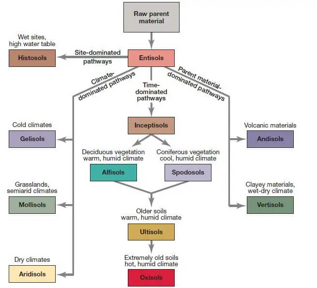
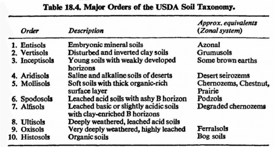
For exam purposes, it is far more useful to group these twelve orders by the underlying factor each best illustrates — maturity, climate, parent material, or organic-matter accumulation — than simply to memorise them alphabetically.
Soils Characterised by Maturity
Entisols and Inceptisols can occur in virtually any climate or latitude, from equatorial to Arctic, because their defining feature is youth rather than a specific environment. Entisols are mineral soils entirely without distinct horizons — they qualify as “soil” only in the sense that they support plant life, often because material has only recently been deposited (river floodplains, dunes, fresh volcanic ash). Inceptisols show only weakly developed horizons, again usually reflecting a young soil age. Entisols and Inceptisols of floodplains and deltas in warm, moist climates are, ironically, among the most agriculturally productive soils in the world, owing to favourable texture, ample nutrients replenished by fresh sediment, and large soil-water storage capacity — the Indo-Gangetic and Brahmaputra floodplains being the classic Indian illustration.
Alfisols and Spodosols both mature further than Entisols/Inceptisols and are distinguished from each other primarily by climate and base status:
- Alfisols possess a clay-rich (argillic) horizon produced by illuviation and retain a relatively high base status. Their world distribution spans an extraordinary latitudinal range, from roughly 60°N in North America and Eurasia down to equatorial South America and Africa. Four important suborders map onto specific climates: Boralfs (cold boreal forest, grey surface/brownish subsoil), Udalfs (brownish, mid-latitude), Ustalfs (brownish-reddish, warmer climates), and Xeralfs (Mediterranean climate, cool moist winter/dry summer).
- Spodosols possess a pale, eluviated albic horizon above a dense, illuviated spodic horizon, developing under cold needle-leaf (coniferous) forests and strongly correlated with areas recently covered by Late Cenozoic ice sheets. They are naturally poor for agriculture and strongly acidic, requiring lime application — this order is the USDA equivalent of the zonal Podzol.
Oxisols and Ultisols represent the most weathered end of the maturity spectrum:
- Oxisols develop in the moist climates of the equatorial, tropical and subtropical zones, on land surfaces that have remained geomorphologically stable over very long periods, allowing weathering to proceed to completion. They dominate vast areas of South America and Africa under rainforest — the USDA equivalent of zonal Ferralsols/Laterites.
- Ultisols are similar but retain a subsurface clay (argillic) horizon; they occur through Southeast Asia and the East Indies, eastern Australia, Central and South America, and the south-eastern United States, and are highly vulnerable to soil erosion on steep hillslopes.
Soils Characterised by Climate
- Mollisols — soils of grasslands in sub-humid to semi-arid climates, with a thick, dark, base-rich surface (the mollic epipedon). Because of their loose crumb texture and high base status, Mollisols are highly productive — dominating the Great Plains, the Columbia Plateau and northern Great Basin of North America, the Pampas of Argentina/Uruguay, and a great steppe belt stretching from Romania across Russia, Siberia and Mongolia. Mollisols are the USDA equivalent of the zonal Chernozem–Chestnut–Prairie continuum.
- Aridisols — desert soils with weakly developed horizons, often showing subsurface accumulation of calcium carbonate or soluble salts; correlate with the arid subtypes of the dry tropical, dry subtropical and dry mid-latitude climates. With irrigation and management they can become fertile — corresponding to zonal Sierozems.
- Gelisols — soils of permafrost regions, churned by freeze–thaw action, generally derived from recent glacial parent material together with slowly decaying organic matter — corresponding to zonal Tundra soils.
Soils Characterised by Parent Material
- Vertisols — develop on certain volcanic rocks in wet–dry climates under grassland/savanna, expanding and contracting with wetting and drying to create deep cracks. Their black colour and high montmorillonite clay content mark them as the USDA equivalent of the zonal Regur (black cotton soil). India’s Deccan Plateau, where basalt weathers into montmorillonite, is cited internationally as a defining Vertisol region.
- Andisols — unique soils forming on relatively recent volcanic ash, typically dark and fertile, occurring across a wide range of latitudes and climates wherever active or recent volcanism has deposited ash.
Soils High in Organic Matter
Histosols — organic soils, often called peats or mucks, typically forming in cool-to-cold climates under conditions of poor drainage; they occur in patches throughout the Spodosol-dominated northern regions and are marked by a very high proportion of organic matter concentrated in a thick, dark upper layer.
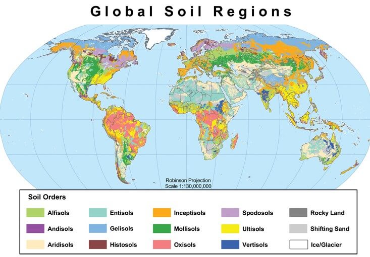
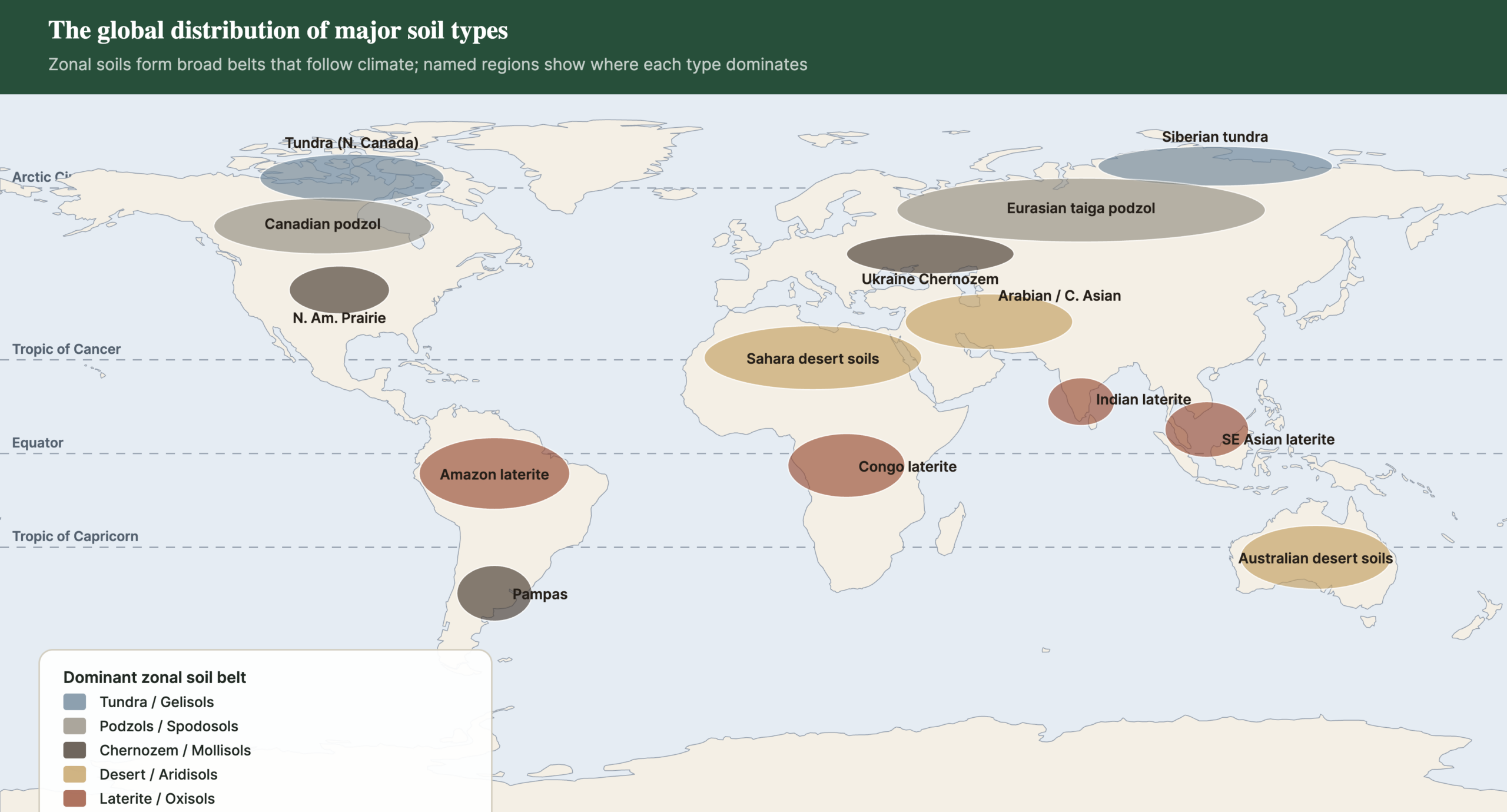
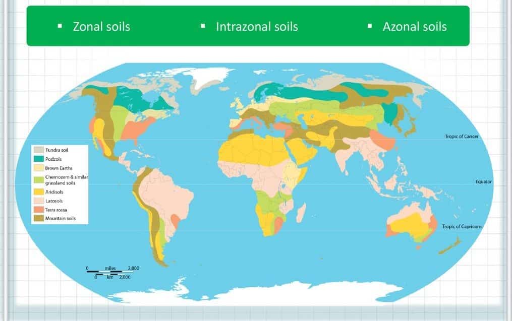
9. Distribution of Soils in the World
| Soil type | USDA equivalent | Principal world regions | Natural vegetation |
|---|---|---|---|
| Tundra soils | Gelisols | Arctic fringe of N. America, Scandinavia, Siberia; Antarctic margins | Moss, lichen, dwarf shrub tundra |
| Podzols | Spodosols | Canada, Scandinavia, N. Russia/Siberia (taiga belt); patches in maritime W. Europe | Coniferous (boreal) forest |
| Brown earths | Alfisols (Udalfs) | Western/Central Europe, NE United States, parts of East Asia | Temperate deciduous forest |
| Chernozems | Mollisols | Ukraine & S. Russian steppe, N. American Prairies (US/Canada), N. China, Argentine Pampa margins | Tall/mixed-grass steppe, prairie |
| Chestnut soils | Mollisols (drier subtype) | Drier margins of the Russian & N. American steppe belts, Central Asia | Short-grass steppe |
| Sierozems | Aridisols | Central Asian deserts, Iranian Plateau, interior Australia, American SW (patches) | Sparse desert scrub |
| Xeralfs (Mediterranean) | Alfisols | Mediterranean basin, coastal California, central Chile, SW Australia, Cape region | Sclerophyllous (“maquis”) scrub & woodland |
| Tropical black/Regur | Vertisols | Deccan Plateau (India), parts of Sudan/Ethiopia, N. Australia, Texas Blackland Prairie | Savanna, tropical grassland |
| Ferralsols/Laterites | Oxisols/Ultisols | Amazon & Congo Basins, Indian Western Ghats & NE Hills, SE Asia, coastal W. Africa | Tropical rainforest |
| Alluvial soils | Entisols/Inceptisols | Indo-Gangetic & Brahmaputra plains, Nile Delta, Mekong & Yangtze deltas, Mississippi Valley | Cropland (naturally: riparian forest/grassland) |
| Andisols | Andisols | Andes, Indonesia, Japan, East African Rift volcanic zones | Variable; often dense montane forest |
| Histosols (peat) | Histosols | Canadian & Siberian bogs, Indonesian/Malaysian peat swamp forest, N. European fens | Bog, fen, peat swamp forest |
Several broad regularities emerge from this table that are worth stating explicitly in an answer:
- Latitudinal zonation dominates at the continental scale — the pole-to-equator sequence tundra → podzol → brown earth/chernozem → chestnut/sierozem → ferralsol broadly recurs on every major landmass, though compressed or expanded by continentality and relief.
- Continentality distorts the pure latitudinal pattern — interior landmasses (Central Asia, the North American interior) develop drier chestnut/sierozem/aridisol belts at latitudes where coastal locations would show forest soils.
- Parent material can override climate locally — the Deccan’s Vertisols and the world’s scattered Andisol patches show that a single rock type (basalt, volcanic ash) can produce a recognisable, mappable soil type across widely different climatic zones.
- Fluvial and deltaic azonal soils are disproportionately important to human settlement — though geologically “immature,” Entisols/Inceptisols of major river floodplains support some of the highest rural population densities on Earth precisely because continuous sediment renewal offsets the lack of profile development.
10. Pedalfers vs Pedocals: The General Two-Fold Classification
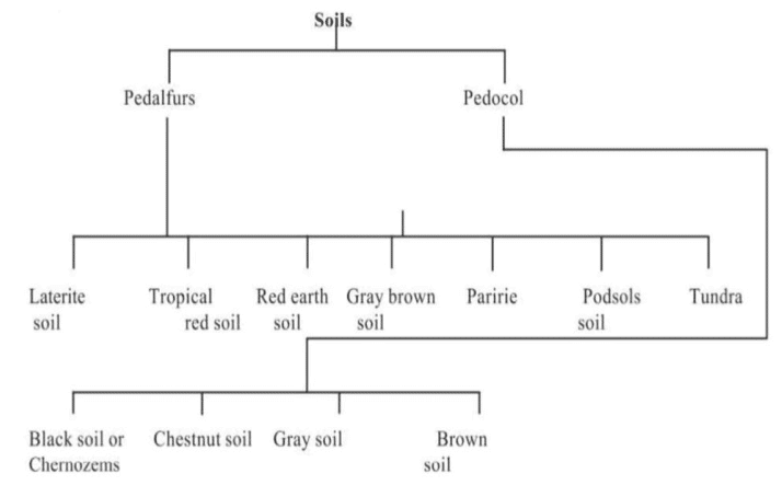
Beyond the detailed zonal and USDA schemes, a simpler and historically important two-fold classification divides world soils by moisture regime and base status:
| Feature | Pedalfers | Pedocals |
|---|---|---|
| Formation environment | Humid regions, under rich vegetation cover | Arid/semi-arid regions, receiving under ~25 inches (~635 mm) rainfall annually |
| Composition | Enriched in aluminium and iron (hence “pedALFer” — Al + Fe) | Retain calcium-rich compounds (hence “pedoCAL”) |
| Base status | Deficient in plant nutrients such as potassium, calcium and phosphorus (leached out) | Retain most nutrient elements needed for plant food; not leached |
| Colour & reaction | Generally darker, more strongly leached, often acidic | Generally lighter in colour, alkaline, not leached |
| Examples | Podzols, Brown earths, Laterites/Ferralsols | Chernozems, Chestnut soils, Sierozems, desert soils |
This pedalfer–pedocal division, together with sub-varieties distinguished by vegetation type, temperature regime, and precipitation amount, forms the “general classification of soil” that many Indian textbooks present as a simplified capstone to the zonal system — useful for quick 10-mark answers where a full zonal/USDA treatment would be disproportionate.
11. Case Study: Classifying India’s Soils
India offers an unusually compact illustration of nearly every principle discussed above, which is why the sub-continent is a favourite reference point in UPSC answers. The traditional Indian Council of Agricultural Research (ICAR) scheme recognises soils largely by genesis, colour and regional occurrence — a scheme that maps cleanly onto both the zonal categories and USDA orders:
| Indian soil type (ICAR) | Approx. zonal/USDA parallel | Region |
|---|---|---|
| Alluvial soils | Azonal — Entisols/Inceptisols | Indo-Gangetic & Brahmaputra plains; deltas of Mahanadi, Godavari, Krishna, Kaveri |
| Black soils (regur) | Zonal (tropical black) — Vertisols | Deccan lava plateau: Maharashtra, Madhya Pradesh, Gujarat, parts of Karnataka & Andhra Pradesh |
| Red & yellow soils | Zonal (transitional Ferralsol) — Alfisols/Ultisols | Eastern & southern peninsular India, Chhattisgarh, Odisha, parts of Tamil Nadu |
| Laterite & lateritic soils | Zonal (Ferralsol) — Oxisols/Ultisols | Western Ghats, Kerala, Karnataka coast, parts of Odisha, Northeast India |
| Arid & desert soils | Zonal (Sierozem) — Aridisols | Western Rajasthan (Thar), parts of Gujarat (Kachchh) |
| Saline & alkaline soils (usar/reh) | Intrazonal (Halomorphic) — Solonchak/Solonetz analogues | Patches in Punjab, Haryana, Uttar Pradesh, Gujarat, coastal deltas |
| Peaty & marshy soils | Intrazonal (Hydromorphic) — Histosol/gley analogues | Kerala (kari/kayal lands), coastal Odisha, parts of Bihar/West Bengal |
| Forest & mountain soils | Zonal (varies with altitude) — Inceptisols/Alfisols/Spodosols | Himalayan ranges, Western Ghats uplands, NE hill states |
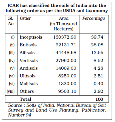
The National Bureau of Soil Survey and Land Use Planning (NBSS&LUP), Nagpur, has since mapped Indian soils formally onto USDA Soil Taxonomy for scientific and land-capability purposes, finding that Indian soils fall predominantly into the orders Entisols, Inceptisols, Alfisols, Vertisols, Aridisols, Mollisols and Ultisols — a striking practical demonstration of how the “traditional” descriptive scheme and the “modern” diagnostic scheme describe the same physical reality from two directions.
12. Comparative Tables at a Glance
Chernozem vs Sierozem (quick recap)
| Feature | Chernozem | Sierozem |
|---|---|---|
| Climate | Semi-arid to sub-humid steppe | Arid/desert |
| Colour | Black/dark brown | Grey |
| Carbonate horizon | Deep in profile | Very close to surface |
| Organic matter | Moderate (~10%), but thick dark layer | Very low |
| Natural fertility | Very high — among world’s best | Low naturally; high once irrigated |
Podzol vs Ferralsol (Laterite)
| Feature | Podzol | Ferralsol / Laterite |
|---|---|---|
| Climate | Cool, humid (boreal) | Hot, humid (tropical) |
| Dominant process | Cheluviation (organic-acid leaching) | Ferrallitisation (intense chemical weathering) |
| Diagnostic horizon | Bleached E horizon | Deep, clayey, oxide-rich B horizon |
| Colour | Ash-grey (upper), rust (lower) | Red/yellow throughout |
| USDA order | Spodosol | Oxisol / Ultisol |
Zonal System vs USDA Taxonomy
| Criterion | Zonal System | USDA Soil Taxonomy |
|---|---|---|
| Basis | Presumed genesis (climate + vegetation) | Observed, measurable diagnostic horizons |
| Origin | Dokuchaev & Glinka, Russia (late 19th c.) | US Dept. of Agriculture (mid-late 20th c.) |
| Categories | Zonal / Intrazonal / Azonal (3 broad classes) | 12 formal orders |
| Strength | Intuitive; links directly to biomes/vegetation — ideal for biogeography | Rigorous, replicable, internationally standardised for mapping & land capability |
| Weakness | Same soil recurs in different climates; azonal class is ambiguous; ignores relict/inherited features | Less intuitive pedagogically; heavier technical vocabulary |





Distribution of soil is not given
You can refer this :
https://digitallylearn.com/global-distribution-of-soil-in-world-upsc-geography-optional-ias-pcs/
Excellent work
Can’t thank you enough!!!!!!!!!
If possible please add pics of soils.