

- Natural vegetation is an endowment of nature: plant cover that grows on its own, following the climatic variables, with no planting by people.
- Its types differ according to precipitation, soil, climate and topography.
- India holds a wide range of flora and fauna. Its diverse geography and climate let an extensive range of vegetation grow, from mangrove to alpine scrub.
- Strictly, the term means the original cover untouched by people. Much of India’s cover has been cleared or altered, so the truly natural part survives mostly in remote Himalayan tracts and the deep Thar.
- A forest, in the ecological sense, is a plant community chiefly of trees and woody plants, usually with a closed canopy.
- The word comes from Latin fores, “outside”, meaning land beyond the village fence.
- In management, it also means land kept for timber and other produce.
Natural Vegetation of India
Factors Influencing Vegetation
- Climate, soil and topography are the major factors influencing the natural vegetation of a place.
- Climate: rainfall and temperature are the main variables.
- The amount of annual rainfall bears heavily on the vegetation type, and the length of the dry season matters as well.
- Outside the mountains, rainfall generally outweighs temperature.
- Temperature becomes the major factor in the Himalaya and other hills above about 900 m.
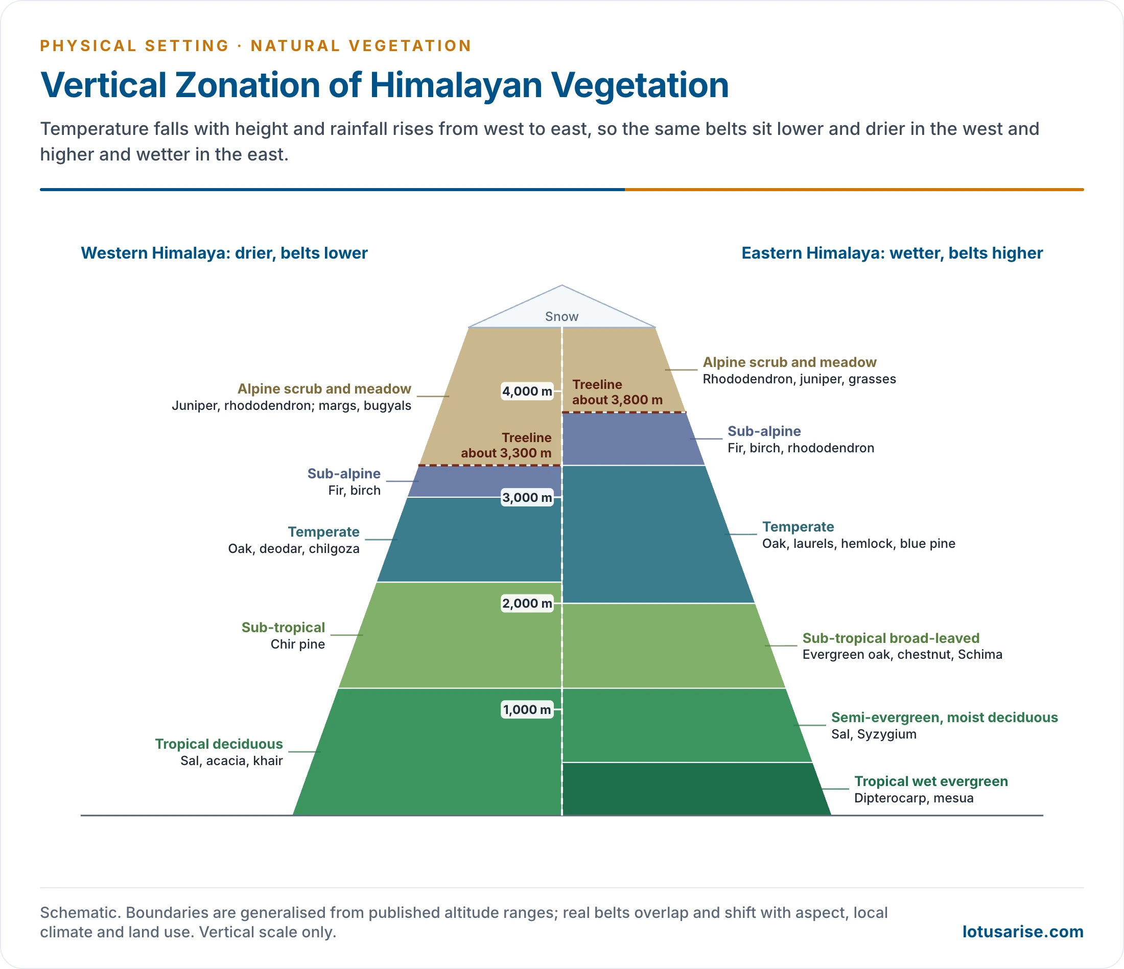
- As temperature falls with height in the Himalaya, the cover changes from tropical to sub-tropical, temperate and finally alpine.
- Soil decides the type in a few regions, as in mangrove and swamp forests, along with beach and sandy coastal forests.
- The link also runs the other way: leaf litter adds humus, and roots and acids from decay help form in situ soils, so forested tracts hold some of the best soils in India.
- Topography accounts for certain minor types, such as alpine flora and tidal forests.
- The vegetation changes step by step with annual rainfall:
| Annual rainfall | Type of vegetation |
|---|---|
| 200 cm or more | Evergreen rain forests |
| 100 to 200 cm | Monsoon deciduous forests |
| 50 to 100 cm | Drier deciduous or tropical savanna, grading into thorny scrub |
| 25 to 50 cm | Dry thorny scrub (semi-arid) |
| Below 25 cm | Desert (arid) |
- Laurence Dudley Stamp put the same idea in four rainfall classes: evergreen above 200 cm, monsoon 100–200 cm, dry 50–100 cm and desert below 50 cm.
- Most of this rain comes from the monsoon, so the rainfall map and the vegetation map match closely.
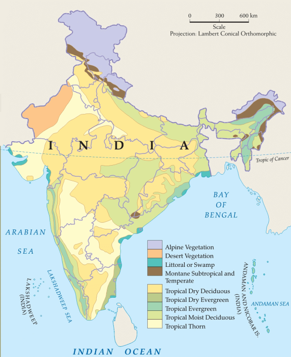
- On this map, the alpine colour over Ladakh also takes in its cold desert.
Origin of the Flora
- Most Himalayan and Peninsular plants are indigenous or endemic. Many plants of the Thar and the Indo-Gangetic Plain came from outside.
- Boreal elements arrived from the Trans-Himalaya (Tibet and China), and palaeo-tropical ones from adjoining tropical lands.
- North African plants influenced the Thar and much of the Great Plains, and Indo-Malaysian ones the north-eastern hills.
- The arrival of exotics continues. Lantana and water hyacinth, both brought in as garden plants, are now troublesome weeds, the second nicknamed the “terror of Bengal”.
- C. C. Calder (1937) divided India into eight floristic regions:
| Region | Typical vegetation |
|---|---|
| Eastern Himalaya | Sub-tropical to alpine, very rich |
| North-Western Himalaya | Sal and savanna below; chir, oak, deodar, birch; alpine pastures above |
| Assam | Bamboos and palms; Nilgiri-type grassland on heights |
| Gangetic Plain | Much altered; semi-arid shrubs to Sundarban mangrove |
| Indus Plain | Thorny and desert plants; grasses in the rains |
| Deccan | Teak, tendu, sal, palm, thorny shrubs |
| Malabar | Moist evergreen to deciduous; temperate on the Nilgiri |
| Andaman and Nicobar | Equatorial evergreen |
Classification of Natural Vegetation of India
- The classification rests mainly on spatial and annual variations in rainfall. Temperature, soil and topography are also considered.
- Harry George Champion (1936) made the first systematic survey, distinguishing 116 types.
- Later revisions came from G. S. Puri (1960), P. Legris (1963), S. S. Negi (1990) and, above all, Champion with S. K. Seth (1968).
- The Champion and Seth (1968) scheme remains standard. It has 5 major groups, 16 type groups and about 202 types and sub-types, the set the Forest Survey of India uses for mapping.
- India’s vegetation thus falls into 5 main types and 16 sub-types:
- A. Moist Tropical Forests
- Tropical Wet Evergreen
- Tropical Semi-Evergreen
- Tropical Moist Deciduous
- Littoral and Swamp
- B. Dry Tropical Forests
- Tropical Dry Evergreen
- Tropical Dry Deciduous
- Tropical Thorn
- C. Montane Sub-tropical Forests
- Sub-tropical broad-leaved hill
- Sub-tropical moist hill (pine)
- Sub-tropical dry evergreen
- D. Montane Temperate Forests
- Montane Wet Temperate
- Himalayan Moist Temperate
- Himalayan Dry Temperate
- E. Alpine Forests
- Sub-Alpine
- Moist Alpine scrub
- Dry Alpine scrub
- A. Moist Tropical Forests
- The older shares come from a total of 64 million hectares. The Forest Survey’s refined map changes the order, and tropical dry deciduous is now the largest type, with moist deciduous second.
| Forest type | Older share (%) | Forest Survey map, 2019 (%) |
|---|---|---|
| Tropical Moist Deciduous | 37 | 17.65 |
| Tropical Dry Deciduous | 28 (28.6) | 40.86 |
| Tropical Wet Evergreen | 8 | 2.61 |
| Sub-Tropical Moist Hill (pine) | 6 (6.6) | 2.36 |
| Tropical Semi-Evergreen | 4 (4.1) | 9.27 |
| Montane Wet Temperate | 3.6 | 2.66 |
| Himalayan Moist Temperate | 3.4 | 3.35 |
| Tropical Thorn | 2.6 | 2.72 |
| Sub-Tropical Dry Evergreen | 2.5 | 0.02 |
| Alpine, including sub-alpine and scrub | 2.1 | 2.47 |
| Littoral and Swamp | 0.6 | 0.73 |
| Sub-Tropical Broad-leaved Hill | 0.4 | 4.26 |
| Himalayan Dry Temperate | 0.3 | 0.73 |
| Tropical Dry Evergreen | 0.2 | 0.12 |
| Plantation and trees outside forest | Not counted | 8.45 |
| Grassland within forest types | Not counted | 1.74 |
- In the older count, every other type falls below 4%.
- The two columns use different bases and methods, so they are not a direct measure of change.
Other Ways of Classifying Forests
- India’s forest resources are also sorted by legal, economic and other types of forests.
- Legal or administrative:
- Reserved (about 54%): under direct state control, with no public entry for timber or grazing.
- Protected (about 29%): state-run, but local people may collect fuelwood and graze cattle without serious damage.
- Unclassed (about 17%): largely degraded and unproductive, with few limits on use.
- Ownership: the government holds most of it. Corporate bodies own some, and private owners hold about 1%, as in Meghalaya, Odisha, Punjab and Himachal Pradesh.
- Composition:
- Coniferous: only about 3.5 million hectares, in the Himalaya (deodar, chir, fir, spruce, pine). They are valuable softwood but are held back by terrain and poor transport.
- Broad-leaved: about 95%, led by sal (16.55%), teak (13.82%) and bamboo (7.48%).
- Exploitability: about half are exploitable, a quarter potentially exploitable, and the rest inaccessible, mainly in the high Himalaya of Kashmir and Arunachal Pradesh.
A. Moist Tropical Forests
Tropical Wet Evergreen Forests or Rain Forests
- Climatic conditions:
- Annual rainfall exceeds 250 cm.
- Temperature stays near 25°–27°C through the year.
- Humidity averages above 77%.
- The dry season is distinctly short.
- Characteristics:
- Evergreen: heat and humidity stay high, so the trees never shed their leaves all together.
- Mesophytic: plants adapted to a climate neither too dry nor too wet.
- Mesophytes are ordinary plants lying between two extremes: hydrophytes, such as water lily or pondweed, which grow in saturated soil or water, and xerophytes, such as cactus, which grow in very dry soil.
- Mesophytic settings have average to hot temperatures and soil of moderate wetness.
- Lofty: trees often reach 45–60 m.
- Thick canopy: from the air, the forest looks like a thick roof of foliage, broken only by large rivers or clearings for cultivation.
- Layered: all plants struggle upwards for sunlight, many of them as epiphytes, and this builds a peculiar multi-layered structure. From above, the whole looks like a green carpet.
- Less undergrowth on the deep-shaded floor: little sunlight reaches the ground, and there are no grasses. What grows is mainly bamboos, canes, ferns and climbers, tangled at gaps and edges, with orchids on the trees.
- Distribution:
- South of Mumbai, the western face of the Western Ghats, between 500 and 1,370 m.
- Some regions of the Purvanchal hills, in a strip through Arunachal Pradesh, Upper Assam, Nagaland, Manipur, Mizoram and Tripura, up to about 1,070 m.
- The Andaman and Nicobar Islands.
- Timber:
- Hardwood: fine grained, hard and durable.
- It has high commercial value but is hard to exploit, because of tangled growth, the absence of pure stands, and poor transport.
- This is the old contrast in world lumbering: mixed hardwoods in equatorial rainforest are costly to work, while pure softwood stands in taiga conditions suit it far better.
- Important species are mahogany (a planted tree of tropical American origin), mesua, white cedar, jamun, canes and bamboo.
- Western Ghats: calophyllum, toon, dhup, palaquium, hopea.
- North-East: gurjan, chaplasha, agar, muli.
Tropical Semi-Evergreen Forests
- These are transitional forests between tropical wet evergreen and tropical deciduous forests, on comparatively drier ground beside the evergreen belt.
- Climatic conditions:
- Annual rainfall is 200–250 cm.
- A mean annual temperature of 24°–27°C.
- Relative humidity is about 75%.
- The dry season is longer than in the evergreen belt.
- Distribution: the western coast, Assam, the lower slopes of the Eastern Himalaya, Odisha and the Andamans.
- Characteristics:
- They are less dense than the wet evergreen forests.
- They are more gregarious, which means they stand more in pure groups, especially in Assam.
- They hold many species.
- Trees usually have buttressed trunks, rougher and thicker bark, heavy climbers and abundant epiphytes, with fewer bamboos.
- Western Ghats species: laurel, rosewood, mesua, thorny bamboo, along with aini, semul, hopea, kadam and irul.
- Himalayan species: white cedar, Indian chestnut, champa, mango, along with bonsum and hollock.
- Timber: hardwood, as in the evergreen forests, but with more pure stands in a thinner forest, so the timber industry fares better here.
Tropical Moist Deciduous Forests
- Climatic conditions:
- Annual rainfall 100–200 cm.
- Mean annual temperature about 27°C.
- Average annual relative humidity 60–75%.
- Spring (between winter and summer) and summer are dry.
- Characteristics:
- Trees drop their leaves for about 6–8 weeks in spring and early summer, when moisture falls short and the sub-soil water cannot meet the need.
- The general look is burnt up and bare in extreme summer (April–May), and it turns green again with the first rains.
- The top storey is irregular, at 25–60 m.
- Trees are heavily buttressed, with a fairly complete shrubby undergrowth, patches of bamboo, climbers and canes.
- These forests cover a much larger area than the evergreen forests, but large tracts have been cleared for cultivation.
- Distribution:
- A belt along the Western Ghats, around the evergreen belt on both slopes.
- A strip along the Shiwaliks, including terai and bhabar, from 77°E to 88°E.
- Manipur and Mizoram.
- Hills of eastern Madhya Pradesh and Chhattisgarh.
- The Chota Nagpur Plateau.
- Most of Odisha.
- Parts of West Bengal.
- The Andaman and Nicobar Islands.
- Timber:
- These provide valuable timber, above all teak.
- Main species are teak, sal, laurel, rosewood, amla, jamun and bamboo, with padauk, haldu, mahua, semul, kusum and tendu.
- They are comparatively easy to exploit, thanks to their high degree of gregariousness, with more pure stands.
Littoral and Swamp Forests
- These can survive and grow in both fresh and brackish water.
- Brackish water is the mixture of seawater and fresh water in estuaries. Its salinity lies between about 0.5 ppt and the 35 ppt of seawater.
- They occur in and around deltas, estuaries and creeks prone to tidal influence, hence the name delta or tidal forests.
- Littoral means relating to the shore of a sea or lake. Such forests fringe the coast at many points.
- Swamp forests keep to the Ganga, Mahanadi, Godavari, Krishna and Cauvery deltas.
- Dense mangroves line sheltered creeks, estuaries, mudflats, salt marshes and backwaters, and they give useful fuelwood.
- Older accounts gave 6,740 sq km, about 7% of the world’s mangroves.
- The India State of Forest Report 2023 maps 4,991.68 sq km (0.15% of the country).
- West Bengal holds 42.45%, Gujarat 23.66% and the Andaman and Nicobar Islands 12.39%.
- The most pronounced and densest is the Sundarban in the Ganga delta, dominated by sundri (Heritiera).
- Timber: hard and durable, used for construction, building and boats.
- Important species are sundri, agar, rhizophora, screw pines, canes and palms, with bruguiera, sonneratia, keora and nipa.
- Named mangrove sites include Bhitarkanika, Coringa, Pichavaram, Point Calimere and the Gulf of Kachchh.
- Why they need these places: mangroves want warm water, a tidal rhythm, fine silt and shelter from strong waves, which is why sheltered deltas suit them.
- Value: they buffer the coast against cyclones and surges, stabilise mud, shelter fish and store carbon.
- The MISHTI initiative of 5 June 2023 aims to restore about 540 sq km across nine coastal States and four Union Territories.
B. Dry Tropical Forests
Tropical Dry Evergreen Forests
- Distribution: along the coasts of Tamil Nadu.
- Climatic conditions:
- About 100 cm of rain a year, most of it from the north-east monsoon in October–December.
- Mean annual temperature about 28°C.
- Mean humidity about 75%.
- Evergreen forest on so little rain is botanically puzzling. The winter timing of the rain may explain it.
- Characteristics:
- Short-statured trees, up to 12 m high, with a complete canopy and leathery leaves.
- Bamboos are rare, and grasses are not conspicuous.
- Important species are jamun, tamarind and neem, with khirni, kokko and ritha.
- Most of this land has been cleared for farming or casuarina plantations.
Casuarina Plantation
- Appearance: it resembles a feathery conifer, and grows 15–25 m high on average.
- Habit: it is a rapid-growing, undemanding species, suited to sites as varied as coastal sand dunes, high mountain slopes, the hot humid tropics and semi-arid regions.
- Nitrogen: it can fix atmospheric nitrogen.
- Distribution: the most popular farm-forestry species in Andhra Pradesh, Tamil Nadu, West Bengal, Odisha, Maharashtra, Gujarat and Karnataka.
- Benefits:
- It reduces damage from natural calamities, and line planting along coasts breaks the force of the wind.
- It serves tourism promotion, thanks to its ornamental look.
- It gives top-quality firewood.
- Its wood suits paper pulp, and so the making of writing, printing and wrapping paper.
- It also has medicinal uses.
- Wasteland development: it adapts to many habitats, grows fast, tolerates salt, resists drought, reclaims land and stabilises sand dunes.
- Intercrops: groundnut, cucumber, watermelon, sesamum and pulses can be raised alongside it.
Tropical Dry Deciduous Forests
- Climatic conditions: annual rainfall 100–150 cm.
- Characteristics:
- Similar to moist deciduous forests, these shed their leaves in the dry season. The main difference is that they grow on less rainfall.
- They are a transitional type: moist deciduous on the wetter side, thorn forest on the drier side.
- The canopy is closed but uneven.
- A few deciduous species mix together, rising to about 20 m.
- Undergrowth: enough light reaches the ground for grass and climbers. Bamboos grow but are not luxuriant.
- Distribution: an irregular wide strip from the foot of the Himalaya to Kanniyakumari, except in Rajasthan, the Western Ghats and West Bengal.
- Important species are teak, axlewood, rosewood, common bamboo, red sanders, laurel and satinwood, with tendu, palas, sal and khair.
- Large tracts have been cleared for farming. The rest suffers from overcutting, overgrazing and fire.
Tropical Thorn Forests
- Climatic conditions:
- Annual rainfall less than 75 cm.
- Humidity less than 50%.
- Mean temperature 25°–30°C.
- Characteristics:
- Trees are low (6–10 m at most) and widely scattered.
- Acacias and euphorbias are very prominent.
- Indian wild date is frequent in damper hollows. The rains bring some grasses.
- Distribution:
- Rajasthan, south-western Punjab, western Haryana, Kachchh and neighbouring parts of Saurashtra.
- In the Thar they thin into a desert type, on under 50 cm of rain, with acacia, cacti, khejra and wild palms.
- The type recurs on the lee side of the Western Ghats, over much of Maharashtra, Karnataka, Telangana, Andhra Pradesh and Tamil Nadu.
- Important species are neem, babul and cacti, with khair, khejra, kanju, palas and ak.
C. Montane Sub-Tropical Forests
Sub-tropical Broad-leaved Hill Forests
- Climatic conditions:
- Mean annual rainfall is given as 75–125 cm. That figure looks low for the eastern belt, since the far eastern Himalaya generally receives 400–450 cm.
- Average annual temperature 18°–21°C.
- Humidity about 80%.
- Distribution: the Eastern Himalaya, east of 88°E, at 1,000–2,000 m.
- Characteristics:
- Evergreen species form a dense forest 20–30 m high.
- Common species are evergreen oaks and chestnuts, with ash and beech, sal on the lower margin and pine on the upper.
- Climbers and epiphytes are common. An epiphyte is a plant that grows non-parasitically on a tree or other plant.
- In the south:
- These forests are less distinct, and occur only in the Nilgiri and Palni hills at 1,070–1,525 m.
- This is a “stunted rain forest”, less luxuriant than the true tropical evergreen.
- The higher Western Ghats (Mahabaleshwar), the summits of the Satpura and Maikal ranges, the Bastar highlands and Mt. Abu in the Aravalli carry sub-types.
- Most have been destroyed or greatly altered.
Sub-tropical Moist Pine Forests
- Distribution:
- The Western Himalaya between 73°E and 88°E, at 1,000–2,000 m.
- Some hilly regions of Arunachal Pradesh, Manipur, the Naga Hills and the Khasi Hills. The pine there is mainly Khasi pine.
- Timber:
- Chir or chil is the dominant tree, and forms pure stands.
- Its timber goes into furniture, boxes and buildings.
- It is tapped for resin and turpentine.
- A grassy floor with little undergrowth is usual.
Sub-tropical Dry Evergreen Forests
- Distribution: the Bhabar, the Shiwaliks and the Western Himalaya, to about 1,000 m.
- Climatic conditions:
- Annual rainfall 50–100 cm, of which 15–25 cm falls in December–March.
- Summers are hot enough, and winters cold enough for frequent frost.
- Characteristics:
- A low scrub forest of small, stunted evergreen trees and shrubs.
- Main species: olive, pistacia and Acacia modesta. Dwarf creeping palm spreads over some tracts.
D. Montane Temperate Forests
Montane Wet Temperate Forests
- Climatic conditions:
- Grows at 1,800–3,000 m above sea level.
- Mean annual rainfall 150–300 cm.
- Mean annual temperature about 11°–14°C.
- Average relative humidity over 80%.
- Distribution:
- High hills of Keralam (Kerala) and Tamil Nadu, where they are known as sholas and start from about 1,500 m.
- The Eastern Himalaya east of 88°E, in the hills of West Bengal, Assam, Arunachal Pradesh, Sikkim and Nagaland.
- Characteristics:
- Closed evergreen forests, with short-boled, branchy trees of large girth.
- Mosses, ferns and other epiphytes cloak the branches, and woody climbers abound.
- Height: older accounts say the trees rarely pass 6 m. Studies of the sholas report trees of about 15–20 m, so the 6 m figure holds only for stunted stands.
- Important species are chilauni, Indian chestnut, birch, plum, machilus, cinnamomum, litsea, magnolia, blue pine, oak and hemlock.
- Deodar is often listed here too, but it belongs mainly to the moist western Himalaya.
- In the south, sholas sit in valley pockets amid rolling grassland, and they have been shrinking for a long time.
Himalayan Moist Temperate Forests
- Climatic conditions: annual rainfall 150–250 cm.
- Distribution:
- The temperate zone of the Himalaya, between 1,500 and 3,300 m.
- They cover the entire length of the range, in Kashmir, Himachal Pradesh, Uttarakhand, Darjeeling and Sikkim.
- Characteristics:
- Mainly coniferous, in mostly pure stands.
- Trees are 30–50 m high.
- The main trees are pines, cedars, silver firs and spruce.
- They form a high but fairly open forest, with a shrubby undergrowth of oaks, rhododendrons and some bamboos.
- Broad-leaved evergreens mix in towards the wetter east. West of about 80°E, on 115–180 cm of rain, deodar dominates in pure stands.
- Timber: fine wood, much used for construction, timber and railway sleepers.
Himalayan Dry Temperate Forests
- Climatic conditions: precipitation below 100 cm, mostly as snow.
- Characteristics: coniferous forests with xerophytic shrubs. The main trees are deodar, oak, ash and olive, along with chilgoza and maple.
- Distribution:
- The inner dry ranges of the Himalaya, where the south-west monsoon is very feeble.
- These are in Ladakh, Lahul, Chamba, Kinnaur, Garhwal and Sikkim.
E. Alpine Forests
- These occur all along the Himalaya at about 2,900–3,500 m, reaching 3,800 m or more with location and species.
- There are three kinds: sub-alpine forest, moist alpine scrub and dry alpine scrub.
- Sub-alpine forests:
- They stand at the upper limit of tree growth, beside alpine scrub and grasslands. They do not grow within that lower alpine scrub.
- They are a mixture of conifers and broad-leaved trees: conifers reach about 30 m, and broad-leaved trees only about 10 m.
- Important species are fir, spruce and rhododendron, with kail, plum and yew.
- Moist alpine scrub: a low, dense evergreen growth of rhododendron and birch, with berberis and honeysuckle. It runs from 3,000 m up to the snowline.
- Dry alpine scrub: the uppermost limit of scrub, made of xerophytic dwarf shrubs, over 3,500 m in the dry zone. Important species are juniper, honeysuckle and artemisia.
- Above the trees lie the summer pastures called margs in Kashmir and bugyals in Uttarakhand.
Vertical Zonation in the Himalaya
- Height changes temperature, and the slope changes rainfall, so vegetation falls into belts stacked one over another. The belts overlap, and shift with aspect and local climate.
- Rainfall rises from west to east, from under 50 cm in the far west to 400–450 cm at the eastern end, so the eastern belts are wetter and climb higher.
- The treeline lies near 3,300 m (±200 m) in the west and 3,800 m (±200 m) in the central and eastern parts. A wider survey records treelines between 3,200 and 4,900 m.
| Belt | Western Himalaya (m) | Central and Eastern Himalaya (m) | Main trees |
|---|---|---|---|
| Tropical | Below about 1,200 | Below about 1,200 (wet evergreen below 500) | Sal, acacia; dipterocarp, mesua in the east |
| Sub-tropical | 1,000–2,200 | 1,000–2,000 | Chir pine in the west; evergreen oak, chestnut in the east |
| Temperate broad-leaved | 1,500–3,000 | 1,500–3,000 | Oak, rhododendron, laurels |
| Temperate conifer | 2,000–3,000 | 2,000–3,300 | Deodar, chilgoza; hemlock, blue pine |
| Sub-alpine | 3,000–3,600 | 3,300–4,200 | Fir, birch, rhododendron |
| Alpine scrub and meadow | Above the treeline | Above the treeline | Rhododendron, juniper, grasses |
The Sixteen Types at a Glance
| Type | Rainfall (cm) | Height or setting | Key species |
|---|---|---|---|
| Wet evergreen | Over 250 | Western Ghats, North-East, islands | Mesua, gurjan |
| Semi-evergreen | 200–250 | Beside the evergreen belt | Laurel, rosewood |
| Moist deciduous | 100–200 | Ghats, Shiwalik foot, Chota Nagpur | Teak, sal |
| Littoral and swamp | Tidal | Deltas, estuaries | Sundri, rhizophora |
| Dry evergreen | About 100 | Tamil Nadu coast | Jamun, tamarind |
| Dry deciduous | 100–150 | Interior Peninsula, plains | Teak, axlewood |
| Thorn | Under 75 | North-west, rain-shadow Deccan | Acacia, babul |
| Broad-leaved hill | 75–125 (given) | 1,000–2,000 m, east | Oak, chestnut |
| Moist pine | Moderate | 1,000–2,000 m, west | Chir |
| Sub-tropical dry evergreen | 50–100 | Up to 1,000 m | Olive, pistacia |
| Montane wet temperate | 150–300 | 1,800–3,000 m | Oak, magnolia |
| Himalayan moist temperate | 150–250 | 1,500–3,300 m | Pine, deodar, fir |
| Himalayan dry temperate | Under 100 | Inner ranges | Deodar, chilgoza |
| Sub-alpine | Snow-fed | Near the treeline | Fir, spruce |
| Moist alpine scrub | Snow-fed | 3,000 m to the snowline | Rhododendron |
| Dry alpine scrub | Dry | Over 3,500 m | Juniper |
Forest Cover and Its Distribution
Current Forest Cover
- The latest national data are in the India State of Forest Report (ISFR) 2023, released on 21 December 2024 from satellite data of late 2021.
- Forest cover is all land of at least one hectare with tree canopy density of 10% or more, whatever its ownership or legal status. It includes orchards, bamboo and palm.
| Class | Area (sq km) | Share of India (%) |
|---|---|---|
| Forest cover | 7,15,343 | 21.76 |
| Tree cover | 1,12,014 | 3.41 |
| Forest and tree cover | 8,27,357 | 25.17 |
| Scrub | 43,623 | 1.33 |
- Canopy classes: very dense (70% or more), moderately dense (40% to under 70%) and open (10% to under 40%).
- Change since 2021: forest and tree cover rose by 1,445 sq km, of which forest cover rose only 156 sq km and tree cover 1,289 sq km.
- Where the gain lies: the decadal analysis in the same report credits most of the gain in forest cover to land outside recorded forest. Trees outside forests form 37.11% of forest and tree cover, so a rising figure does not mean more natural forest.
- Against the goal: the National Forest Policy, 1988 seeks one-third of the land under forest or tree cover, and two-thirds in the hills. Hill districts stand at about 40% forest cover.
- Other figures: bamboo-bearing area 1,54,670 sq km, growing stock 6,430 million cubic metres and forest carbon stock 7,285.5 million tonnes.
- Global context:
- The FAO’s Global Forest Resources Assessment 2025 puts world forest at 4.14 billion hectares, 32% of the land, or about 0.5 hectare a person.
- India ranks ninth by forest area (about 72.7 million hectares, some 2% of the world) and third in net annual gain.
- Earlier comparisons gave India 0.06 hectare a person against a world figure of 1.08.
How the Cover Has Changed
- Forest Survey assessments began in 1987. The early series stayed nearly flat, and the jump after 1999 partly reflects finer satellite data.
| Assessment | Forest cover (sq km) |
|---|---|
| 1987 | 6,40,819 |
| 1991 | 6,39,364 |
| 1995 | 6,38,879 |
| 1999 | 6,37,293 |
| 2003 | 6,77,816 (20.6%) |
| 2023 | 7,15,343 (21.76%) |
Distribution by State and Region
- Largest forest cover by area (2023): Madhya Pradesh (77,073 sq km), Arunachal Pradesh (65,882 sq km) and Chhattisgarh (55,812 sq km).
- Highest share of own area (2023): Lakshadweep (91.33%), Mizoram (85.34%) and the Andaman and Nicobar Islands (81.62%).
- Above 75%: Mizoram, Lakshadweep, Andaman and Nicobar Islands, Arunachal Pradesh, Nagaland, Meghalaya, Tripura and Manipur.
- Above 33%: 19 States and Union Territories in all.
- The North-East holds 67% forest and tree cover, though it lost 327 sq km of forest cover since 2021.
- Lowest shares in the older data: Punjab (3.09%), Haryana (3.59%) and Rajasthan (4.63%), then Uttar Pradesh (5.86%), Bihar (5.92%), Gujarat (7.51%) and Jammu and Kashmir (9.57%).
- Why the gaps:
- Scant rain in Rajasthan and Gujarat.
- Clearing for farms in Punjab, Haryana, Uttar Pradesh and Bihar.
- Snow, bare slopes and low rain in the high Himalaya of Jammu and Kashmir and Ladakh.
- Rain shadow in the semi-arid Deccan.
- Clearing for cultivation on the wetter Tamil Nadu and Andhra coasts.
- Forests are scarcest where they are needed most, as in the crowded Ganga plain, with about 5% of its area under forest.
- By region (older shares of India’s forest):
| Region | Share (%) |
|---|---|
| Peninsular plateau and hills | 57 |
| Himalayan region | 18 |
| Western Ghats and west coast | 10 |
| Eastern Ghats and east coast | 10 |
| Great Plain | 5 |
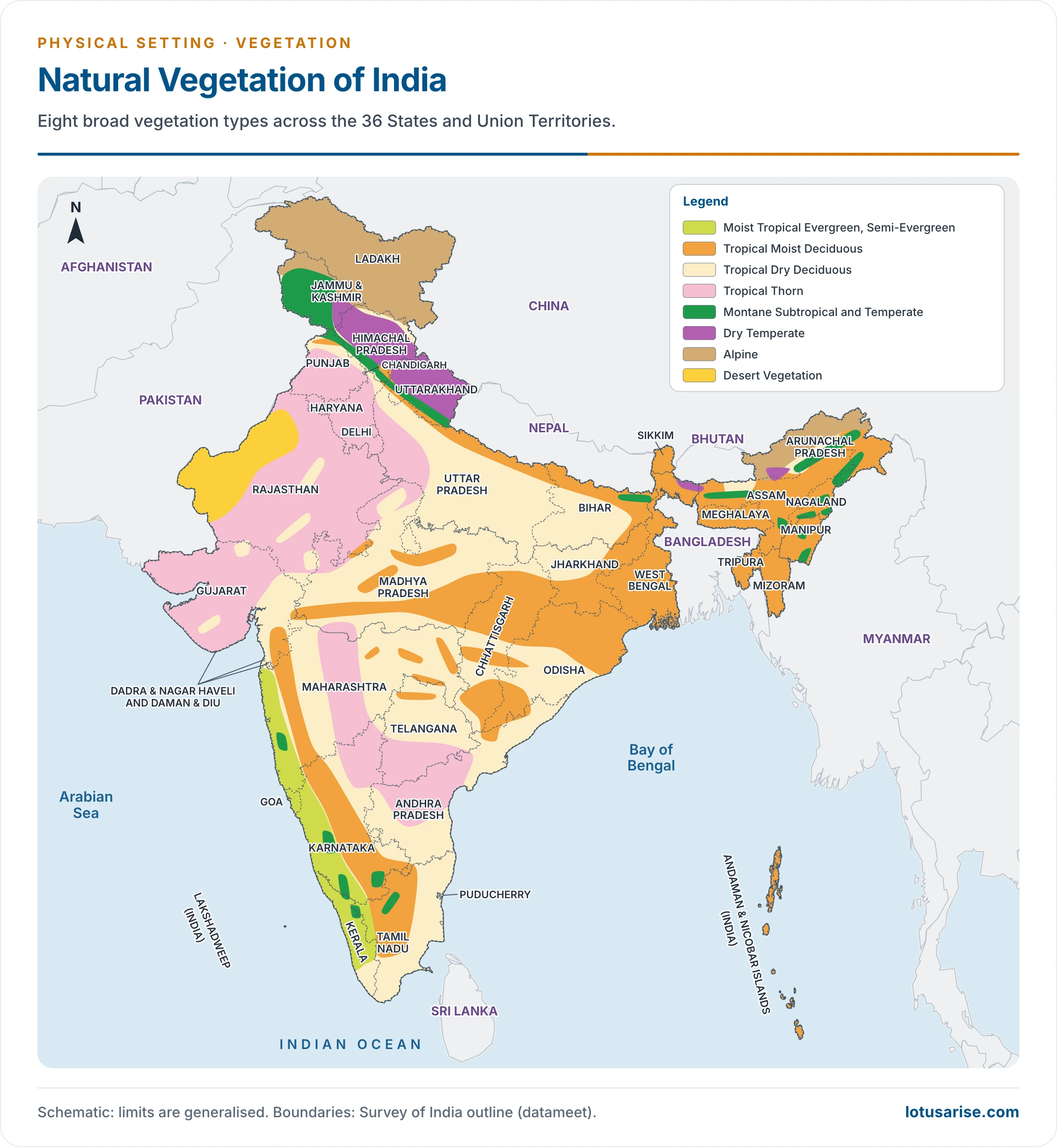
- Ladakh became a separate Union Territory in 2019, and Dadra and Nagar Haveli merged with Daman and Diu in 2020.
Forests as a Resource and Their Protection
- Direct and indirect value: forests supply timber, fuelwood and minor produce such as bamboo, tendu leaves, lac, gums and resin. They also check erosion, floods and the spread of sand, and moderate climate.
- Problems of deforestation and conservation: low cover and productivity, grazing, fires and pests, shifting cultivation, diversion of land, and poor transport.
- People and planting: social forestry spreads tree planting on farm and community land, in response to the National Commission on Agriculture (1976).
- Law and policy:
- Forest policies date from 1894, 1952 and 1988.
- The Forest (Conservation) Act, 1980 curbs diversion. Under the 2023 amendment, in force since 1 December 2023, it is now the Van (Sanrakshan Evam Samvardhan) Adhiniyam, 1980.
- Fires: the 2023–24 season saw 2,03,544 fire hotspots, against 2,12,249 in 2022–23.
Previous Year Questions
2026Explain the vertical zonation of vegetation of the Himalayas.2026Describe the geographical conditions necessary for the growth of mangrove forests in India. Explain their ecological and economic significance.2019Discuss the rainfall pattern and correlate it with the spatial distribution of natural vegetation in India.2017Justify the inclusion of Meghalaya in Peninsular India and discuss its vegetation and soil types.2015How does natural vegetation affect the formation of in situ soils?2010Discuss the spatial distribution of Natural Vegetation in India with the help of a sketched map.2001Explain the sequence of vegetation zones of the Himalayas.1996Discuss the distribution and characteristics of the evergreen forest in India.1993Explain the geographical factors responsible for the growth of mangrove vegetation in India and discuss its role in coastal ecology.





 History Optional PYQ Master Pack: Topic-wise Model Answers (1985–2025) by LotusArise IAS
 History Optional Mains Master Kit 2027 Complete Self-Study System — Notes, Mapping & Premium Articles by LotusArise IAS
It’s really very helpful for me
Thanku soooooooooooooooooooooooooooooooooooooooooooooooooooooooooooooooooooooooooooooooooooooooooooooooooooooooooooooooooooooooooooooooooooooooooooooooooooooooooooooooooooooooooooooooooooooooooooooooooooooooooomuch
Really helpful
Please include mangrove forest it is important for mains exam
See Littoral and Swamp Forest
👍🏽