

- Soil is the thin, weathered mantle of the Earth’s crust, made of mineral particles, organic matter, water and air, that is capable of supporting plant life.
- Pedology treats it as a three-dimensional natural body: it has length and breadth across the landscape and, critically, depth, along which its properties change in an orderly way.
- A soil profile is the vertical section of a soil from the ground surface down to the unaltered parent material, exposed in a natural cut (a river bank, a gully side) or an artificial one (a soil pit, a road cutting).
- It reveals a sequence of more or less distinct layers, the soil horizons, each differing from those above and below in colour, texture, structure, consistence, chemical composition and biological activity.
The Soil Profile and Its Units

The three broad layers
- A mature profile is traditionally read as three broad horizontal layers:
- Solum (true soil), subdivided into topsoil and subsoil.
- Substratum, the underlying, less altered material.
- Bedrock, the unweathered parent rock at the base.
- The layers differ in feel (texture), colour, depth and chemical composition. The differences arise from in-situ processes working inside the soil itself:
- Leaching, the downward removal of soluble and suspended material by percolating water.
- Capillary movement, the upward rise of water and dissolved salts drawn by evaporation at the surface.
- The same two movements make some horizons richer and others poorer in nutrients.
- A profile is studied as a whole column, so that all horizons are seen together, in sequence and undisturbed.
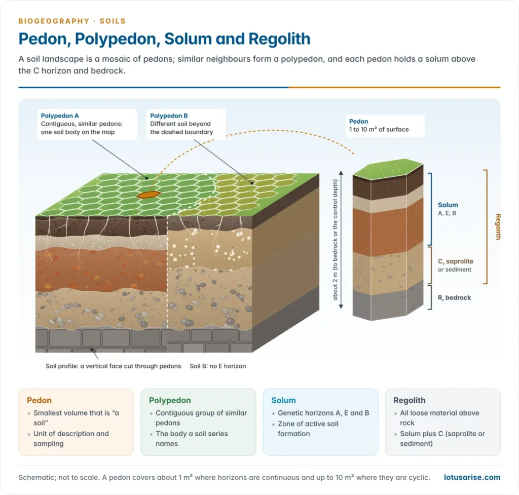
- The sampling unit, the pedon, is often pictured as a hexagonal column of soil.
- For display and teaching, an intact vertical slab, a soil monolith, is lifted from the pit wall and preserved.
Pedon, polypedon, solum and regolith
- Regolith is the entire mantle of loose weathered material above solid bedrock, from the surface humus down to the point where fresh rock begins.
- It has two parts:
- Solum: the upper part of the regolith in which soil-forming processes are active, broadly the A, E and B horizons: soil in the strict pedological sense.
- Saprolite: the least weathered part of the regolith, lying on consolidated bedrock. It keeps the fabric of the parent rock (veins, joints, layering) but is chemically altered and soft enough to dig with a spade; it corresponds to the lower C (Cr) horizon.
- It has two parts:
- The regolith framework ties the soil profile to the weathering profile of geomorphology, the column produced by weathering, and so to laterite and duricrust formation.
- It also explains why the C horizon equals saprolite only in residual soils. In soils formed on transported material (alluvium, loess, glacial till), there is no in-situ parent rock beneath, and the C horizon is simply unaltered sediment.
- The pedon (Greek pedon, ground) is the smallest three-dimensional body that can still be called “a soil”: a column large enough to show the full nature and arrangement of its horizons.
- Its surface area is about 1 to 10 m²: about 1 m² where horizons are continuous, and up to 10 m² where horizons are cyclic or broken, as in the gilgai of black soils or frost-patterned ground.
- Its depth runs through the solum to the parent material, conventionally to about 2 m, or to bedrock if that is shallower.
- The concept was introduced by the US Soil Survey Staff in the 1960s as the unit of soil description and sampling.
- A polypedon is a group of contiguous, similar pedons, bounded by “not-soil” or by pedons of a different kind. It is the real landscape body that a soil series describes and that a soil map unit draws.
- Solum vs pedon:
- The solum is a vertical part of a profile (its genetic horizons), defined by process.
- The pedon is a three-dimensional volume that includes the solum and some of the material beneath it, defined for sampling and classification.
- A solum can be thin or absent (a young sand), but every pedon has a solum, a C horizon or both.
| Term | What it is | Dimensions | Main use |
|---|---|---|---|
| Soil profile | Two-dimensional vertical face of a soil | Surface to parent material | Field description |
| Solum | Genetically altered upper part (A, E, B) | Depth of active pedogenesis | Process and genesis |
| Regolith | All loose material above bedrock (solum + C/saprolite) | Centimetres to tens of metres | Weathering, geomorphology |
| Pedon | Smallest volume that is “a soil” | 1–10 m² surface; about 2 m deep | Sampling, classification |
| Polypedon | Contiguous group of similar pedons | Many pedons; hectares | Soil series, mapping |
Describing a profile in the field
- A profile is described from the top down, horizon by horizon, on a freshly cleaned pit face. For each horizon the surveyor records:
- Depth and thickness of the horizon, and its boundary: distinctness (abrupt under 2 cm, clear, gradual, diffuse over 15 cm) and shape (smooth, wavy, irregular, broken).
- Colour (by the Munsell chart), texture, structure, consistence, roots, pores, mottles, concretions and reaction to acid. These physical and chemical properties are what separate one horizon from the next.
- Soil depth is graded by the depth to bedrock or another root-limiting layer:
- very shallow (under 25 cm), shallow (25–50 cm), moderately deep (50–100 cm), deep (100–150 cm) and very deep (over 150 cm).
- Exposed or shallow bedrock is mapped separately, since it carries very different land-use and engineering limits.
Why Horizons Form: The Genetic Framework
- Horizons are not arbitrary layers: they are the products of pedogenesis, so each one should be read back to the process that made it.
Dokuchaev: soil as an independent natural body
- Vasily Dokuchaev (1883), the founder of modern pedology, held that soil is not merely disintegrated rock but an independent natural body formed by climate, organisms, parent material and relief acting over time.
- This moved soil science from a purely geological view to an ecological–genetic one.
- It laid the basis of the zonal, intrazonal and azonal grouping of world soils, which rests on how fully a soil has been able to develop its horizons.
Jenny’s CLORPT and horizon expression
- Hans Jenny (1941) put this as a state-factor equation, S = f (cl, o, r, p, t): soil is a function of climate, organisms, relief, parent material and time. The factors of soil formation show up in the profile as follows:
- Climate sets the intensity of leaching, the rate of chemical weathering and biological activity, and so horizon thickness and the depth of translocation: deep, strongly differentiated profiles in humid climates; thin, weak ones in arid lands.
- Organisms (vegetation, soil fauna, microbes) control humus accumulation in the O and A horizons and drive nutrient cycling. Forests build litter layers; grasses build deep, dark A horizons.
- Relief controls drainage and erosion, and hence whether horizons can accumulate undisturbed (the catena, below).
- Parent material supplies the starting mineralogy on which weathering and translocation act.
- Time is the factor of profile maturity: a young soil (an Entisol) shows almost no horizons, while an old, stable surface allows a fully differentiated profile with distinct E, Bt or Bk horizons.
Processes that build horizons
- Every horizon is the net result of four groups of processes acting on the parent material:
- Additions to the profile: litter, dust, salts, sediment.
- Losses from it: leaching to groundwater, erosion, gases.
- Translocations within it: clay, iron, humus and salts moved down by percolation or up by capillarity.
- Transformations in place: weathering of minerals to clay, decay of litter to humus.
- Eluviation is the washing out of material from a horizon; illuviation is its washing in to a lower horizon. The pair creates the classic E-over-B relationship.
- Horizonation (processes that sort the profile into layers) competes with haploidisation (processes that mix it back into uniformity), terms used by Francis D. Hole (1961).
- Mixing agents (pedoturbation) include earthworms, termites, ants, burrowing mammals, tree-throw, frost churning and the shrink–swell of clays.
- Where mixing outruns sorting, the profile stays simple (A–C) even when it is old, as in black cotton soils.
Soil-forming regimes and the horizons they leave
- Specific soil-forming processes give horizons their chemical signatures. Each is the mechanism behind a particular eluvial (upper) and illuvial (lower) pair:
- Podzolisation: intense leaching of iron, aluminium and organic colloids in cool, humid, coniferous-forest climates. It leaves a bleached E horizon over an iron- and humus-enriched Bh/Bs horizon.
- Laterisation: intense chemical weathering under hot, humid tropical conditions. Silica and bases are leached while the relatively insoluble sesquioxides of iron and aluminium accumulate residually, giving a red, oxide-rich B horizon and, at the extreme, laterite duricrust.
- Calcification: accumulation of calcium carbonate in the B horizon (a Bk or kankar horizon) in semi-arid to sub-humid climates, where evapotranspiration exceeds rainfall for much of the year and leaching stops at a shallow depth.
- Salinisation: upward capillary movement and surface accumulation of soluble salts in arid and poorly drained land, giving saline (solonchak) surface horizons (Az).
- Gleisation: waterlogging and reduction of iron, giving grey-blue gleyed horizons (Bg, Cg) with rusty mottles where air re-enters.
| Regime | Climate and setting | Profile signature | Typical soil |
|---|---|---|---|
| Podzolisation | Cool, humid; conifers, heath | O (mor) – thin A – bleached E – Bh/Bs – C | Podzol (Spodosol) |
| Laterisation | Hot, humid tropics | Thin A – deep red Bo – plinthite or crust – pallid saprolite | Ferralsol (Oxisol), laterite |
| Calcification | Semi-arid to sub-humid grassland | Thick dark A – Bk (carbonate) – C | Chernozem, Kastanozem |
| Salinisation | Arid, high water table | Salt crust Az – Bz – C | Solonchak |
| Gleisation | Waterlogged hollows | O/A – grey Bg with mottles – Cg | Gleysol |
Why well-developed soils show distinct layers
- Water moves vertically through soil, so materials are sorted by depth: dissolved and suspended material leaves the top and is deposited** where the water slows, evaporates or meets a chemical change (higher pH, more clay, a drying front).
- Organic inputs are concentrated at the top. Litter falls on the surface and most roots lie in the upper 30–50 cm, so humus, biological activity and nutrients decline with depth.
- Weathering decreases with depth, because water, acids and oxygen are strongest near the surface; the profile therefore grades from strongly altered solum to fresh rock.
- Time sharpens the layers.
- A thin A horizon can form in decades; a bleached E and spodic B in centuries to a few thousand years; a clay-rich Bt usually needs several thousand years; and the deep oxic horizons of laterites need hundreds of thousands of years on stable surfaces.
- Distinct layering therefore needs a stable surface, percolating water, vegetation and time, and is weak where erosion, deposition or pedoturbation keep resetting the profile.
Master Horizons
Organic and mineral horizons
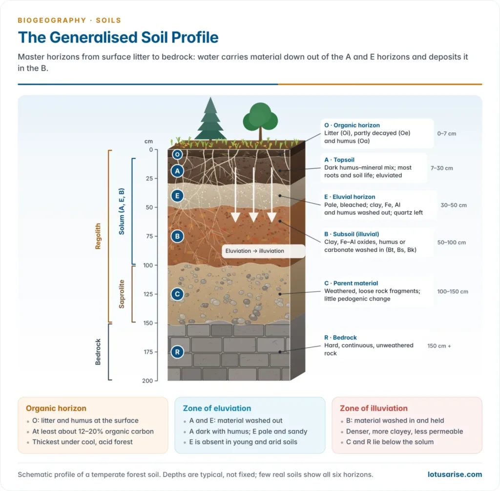
- Horizons develop through the interaction of climate, living organisms and the land surface over time, by the selective removal or accumulation of ions, colloids and compounds carried by water percolating from the surface downward. Horizons at different depths therefore display markedly different textures and colours.
- There are two fundamental categories:
- Organic horizons, designated O, lie above the mineral horizons and are formed from plant and animal remains.
- Mineral horizons are of four main types, A, E, B and C, with R for bedrock as a fifth reference layer.
- The dividing line is organic carbon. Organic soil material carries roughly 12–20% or more organic carbon by weight (about 20–35% organic matter), depending on clay content and wetness; the World Reference Base uses 20% organic carbon as its threshold. Mineral horizons carry less.
| Basis | Organic (O) horizons | Mineral (A, E, B, C) horizons |
|---|---|---|
| Composition | Litter and humus; at least about 12–20% organic carbon | Mostly sand, silt, clay; under about 12–20% organic carbon |
| Position | At the surface (or the whole profile in peats) | Below the O horizon down to bedrock |
| Origin | Additions of leaves, twigs, moss, dead fauna | Weathering of parent material plus translocation |
| Bulk density | Very low (under about 0.5 g/cm³) | Higher (about 1.1–1.8 g/cm³) |
| Water and CEC | Holds several times its weight of water; very high CEC | Lower; set by clay and humus content |
| Colour | Black to dark brown | Dark (A), pale (E), red, yellow or brown (B), rock-coloured (C) |
| Sub-divisions | Oi, Oe, Oa (or L, F, H) | A, E, B, C with suffixes |
| Best developed | Cool, wet, acid forests; bogs and peats | All soils; most differentiated in humid climates |
| Examples | Mor under Himalayan conifers; peats; kari soils of Kuttanad | Chernozem A, podzol E, laterite B, alluvial C |
O horizon (organic)
- Layers dominated by organic material rather than mineral matter: undecomposed or partly decomposed leaves, needles, twigs, moss and lichens.
- Sub-divided by the degree of decomposition:
- Oi: slightly decomposed (fibric) litter in which leaves, twigs and needles are still recognisable. Older schemes call it the L (litter) layer.
- Oe: moderately decomposed (hemic) material, the F (fermentation) layer.
- Oa: highly decomposed (sapric) humus with no visible plant structure, the H (humus) layer.
- Humus forms describe how the organic layer meets the mineral soil:
- Mor: a thick, acid O horizon resting sharply on the mineral soil, decomposed mainly by fungi (conifers, heath).
- Moder: intermediate, with partial mixing by small arthropods.
- Mull: litter rapidly worked into the A horizon by earthworms, leaving little or no O horizon (grasslands, deciduous forest on base-rich soils).
- O horizons may overlie mineral or organic soils. Histosols (peat and muck soils) are almost wholly O material: 40 cm or more of it within the upper part of the profile.
- In India the acid, peaty kari soils of Kuttanad (Kerala), below sea level and waterlogged, are the best-known organic soils.
- Best developed under forest where decomposition is slow (cool, moist or acid conditions); thin or absent in grasslands, the humid tropics (litter decays within months) and cultivated soils, where litter is quickly mixed in or removed.
A horizon (topsoil)
- The upper part of the true soil and the layer most examined for agriculture.
- Organic matter is mixed with mineral matter: it is the horizon of maximum humus and biological activity (roots, earthworms, microbes).
- Usually the darkest mineral horizon, owing to humus; its dark colour and crumb or granular structure make it the most fertile part of the profile.
- It is also a zone of eluviation: clay, iron, aluminium, organic compounds and soluble constituents are dissolved or dispersed and carried down out of it.
- Where this depletion is strong, a distinctly lighter E horizon appears immediately beneath.
- Ap marks a ploughed or otherwise disturbed surface layer in cultivated soils.
- In the older (pre-1981) notation, the A horizon was split into A1 (the dark, humus-rich A of today), A2 (the leached layer, now called E) and A3 (transitional to B).
E horizon (eluvial)
- E stands for eluviated, from the Latin ex (out) and luere (to wash).
- A light-coloured, leached layer that has lost much of its fine material and nutrients to the horizons below.
- It has been stripped of clay, iron and aluminium oxides and humus, leaving a residual concentration of resistant, coarse minerals, chiefly quartz, in the sand and silt sizes. Hence its pale, ashy or bleached look: the classic podzol “ash layer” (Russian podzol, “under ash”).
- E horizons occur in older, well-developed soils, sandwiched between the A and B horizons.
- Their presence or absence is diagnostic:
- a sharp, well-expressed E horizon marks podzols under coniferous forest and the albic layers of some Luvisols (Alfisols);
- it is usually absent in young soils, arid soils and most Indian tropical soils, where laterisation (residual accumulation, not clean eluviation) or too little leaching time prevents it.
B horizon (subsoil)
- A subsurface layer showing chemical or physical alteration of the parent material: the horizon of maximum illuviation (accumulation), the mirror image of eluviation.
- It receives material leached from the A and E horizons, so iron, clay, aluminium, humus and carbonates accumulate here. A B horizon can also form in place, by weathering that changes colour and structure without much inwash.
- Suffixes show what has accumulated:
- Bt: translocated silicate clay (the argillic horizon of Alfisols and Ultisols).
- Bw: weak alteration of colour or structure without significant illuviation (the cambic horizon).
- Bh, Bs: illuvial humus and iron–aluminium sesquioxides with organic matter (the spodic horizon, the classic podzol B).
- Bo: residual iron and aluminium oxides (the oxic horizon of laterites).
- Bk: secondary calcium carbonate (the calcic horizon, the kankar layer of Indian black and arid soils).
- By, Bz: gypsum and soluble salts respectively.
- Bss, Bn, Bg: slickensides (black soils), sodium (alkali soils) and gleying (waterlogged soils).
- The B horizon is usually denser, more compact and higher in clay than the A, so it is less permeable. A clay-rich Bt or a cemented pan can hold a perched water table and restrict roots.
C horizon (parent material)
- The layer of partially weathered parent material little affected by pedogenesis. In transported deposits it is literally the parent material of the solum above.
- It is the least weathered horizon with any soil character. In residual soils it is the saprolite: loose, rotten rock that keeps the rock’s fabric (designated Cr where it is weathered bedrock).
- It may hold soluble compounds leached all the way down (calcium carbonate, gypsum nodules) that have not yet left the profile.
- In residual soils the C grades gradually into bedrock; in transported soils (alluvium, loess, colluvium) it may bear no genetic relationship to the rock beneath. A change of material is shown by a numeral prefix (2C, a lithologic discontinuity).
R horizon (bedrock)
- The layer of unweathered or minimally weathered bedrock at the base of the profile: a continuous mass of hard, coherent rock, not loose particles.
- Soils formed in situ (residual soils) show strong mineralogical and structural similarity to their R horizon.
- This is the key test separating residual soils (for example regur over Deccan basalt, red soils over gneiss) from transported soils such as alluvium, which bear no such relationship to what lies beneath.
The idealised master horizon sequence
| Horizon | Common name | Key characteristic | Typical depth |
|---|---|---|---|
| O | Organic, litter | Undecomposed to well-decomposed organic matter | 0–5 cm |
| A | Topsoil | Humus–mineral mixture; zone of eluviation | 5–25 cm |
| E | Eluvial horizon | Light-coloured; leached of clay, Fe, Al | 25–45 cm |
| B | Subsoil | Zone of illuviation; clay, Fe, Al or carbonate accumulation | 45–100 cm |
| C | Parent material, saprolite | Weathered, unconsolidated parent material | 100–160 cm |
| R | Bedrock | Consolidated, largely unweathered rock | Below about 1.6 m |
- The depths are those of a moderately developed temperate forest soil; real profiles range from a few centimetres to many metres.
- No single profile displays all six horizons. The number and thickness of horizons are themselves a function of the CLORPT factors.
- A young alluvial soil on the Gangetic plain may show only a weak A–C profile; an old podzol under Himalayan conifers shows O–A–E–B–C; a mature laterite in Kerala shows A–B–C many metres thick but no E.
- Degree of horizonation is a proxy for soil age, and is used directly in soil classification: it separates Entisols and Inceptisols from Alfisols, Ultisols and Spodosols in USDA Soil Taxonomy, and azonal from zonal soils in the older Russian scheme.
Horizon designations: transitions, suffixes and diagnostic horizons
- Transitional horizons carry two capitals: AB, BA, BC (dominant one first) where properties grade; E/B or B/E where tongues of one horizon interfinger with another.
- Besides O–R, current USDA usage adds L (limnic layers laid down in water), W (water layers within soil) and M (root-limiting human-made layers).
- Common suffixes (lower-case, written after the capital):
| Suffix | Meaning | Suffix | Meaning |
|---|---|---|---|
| a, e, i | Sapric, hemic, fibric organic matter | o | Residual sesquioxides |
| b | Buried genetic horizon | p | Ploughed or disturbed |
| c | Concretions or nodules | s | Illuvial sesquioxides and humus |
| g | Strong gleying | ss | Slickensides |
| h | Illuvial humus | t | Illuvial silicate clay |
| k | Carbonate accumulation | v | Plinthite |
| m | Cemented (a pan) | w | Colour or structure only |
| n | Sodium accumulation | x, y, z | Fragipan; gypsum; soluble salts |
- Genetic horizons (A, Bt, Bk) are field descriptions. Classification uses quantitatively defined diagnostic horizons: surface epipedons (mollic, umbric, ochric, histic) and subsurface horizons (argillic, spodic, oxic, calcic, natric, cambic).
- The mollic epipedon defines Mollisols (chernozems); the spodic horizon defines Spodosols (podzols); the oxic horizon defines Oxisols (ferralsols, laterites).
Profiles Across Landscapes and Soil Types
The catena: horizons across a slope
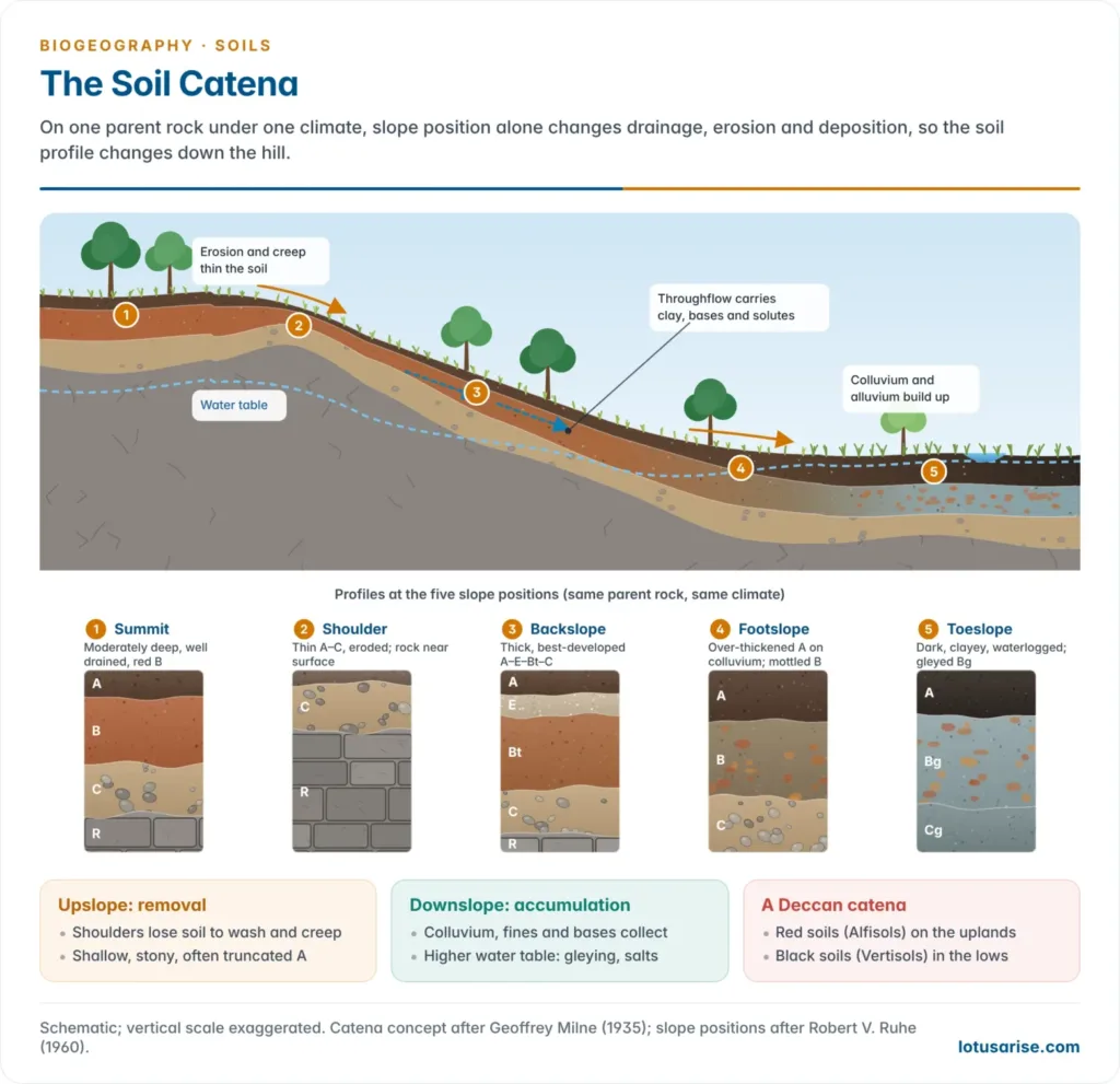
- A purely vertical reading of the profile is incomplete without its lateral setting, the catena (Latin, “chain”), a concept formalised by Geoffrey Milne (1935) from work in East Africa.
- A catena is a sequence of soils down a hillslope, formed from the same parent material under the same climate, that differ because of drainage and slope position.
- A toposequence is the broader term for any soils that differ mainly because of relief; Milne’s catena also allowed for material being moved downslope from one soil to the next.
- On a typical slope:
- Summit and shoulder soils are shallow, well drained and often have truncated or weak A horizons because of active erosion.
- Backslope (mid-slope) soils are usually the best developed, since material is neither excessively removed nor excessively received; on steep backslopes creep thins them.
- Footslope and toeslope soils receive colluvium and alluvium from upslope, are often poorly drained, and show gleyed (bluish-grey, waterlogged) horizons, thicker A horizons and more illuvial accumulation (thick Bt, carbonate or salt).
| Slope position | Main process | Drainage | Typical profile |
|---|---|---|---|
| Summit | Leaching, slow erosion | Well drained | Moderately deep, oxidised (red) |
| Shoulder | Erosion, creep | Excessive | Thin A–C or A–R |
| Backslope | Transport through the slope | Well to moderately drained | Thick, well-developed A–B–C |
| Footslope | Colluvial deposition | Imperfect | Over-thickened A; mottled B |
| Toeslope | Alluvial deposition; seepage; salts | Poor | Gleyed, dark, often clayey or saline |
- The red–black soil association of the Deccan is India’s classic catena: red soils (Alfisols) on the convex uplands, where the landscape is being lowered, and black soils (Vertisols) on lower slopes and depressions, where fine clay and bases collect. The two lie side by side at the ICRISAT farm, Patancheru (Telangana).
- The lateral dimension links the profile to slope development, drainage and land capability, so it recurs across geomorphology, soil geography and agricultural geography.
Profiles of zonal, intrazonal and azonal soils
- In the zonal scheme each group has a characteristic profile, which is how the groups are recognised in the field:
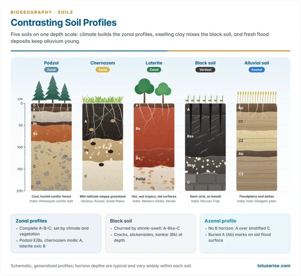
- Zonal soils are mature soils with complete A–B–C profiles that reflect the climate and vegetation of their belt: podzols, chernozems, laterites, desert soils.
- Intrazonal soils have well-developed profiles dominated by one local factor, drainage, salts or rock type, that overrides climate, so they occur inside several climatic zones.
- Azonal soils are immature soils without a B horizon, usually A–C or A–R, because time, steep slopes or continual deposition have not allowed horizons to form.
| Group | Soil | Profile | Key profile features |
|---|---|---|---|
| Zonal | Podzol | O – A – E – Bh/Bs – C | Mor humus; ash-grey E; rusty, humus-rich B; acid |
| Zonal | Chernozem | A – Bk – C | Very thick black mollic A (often 50–100 cm); carbonate Bk; animal burrows (krotovinas); loess C |
| Zonal | Laterite (Ferralsol) | A – Bo – plinthite – C | Thin A; deep red oxic B; iron crust; pallid zone; saprolite tens of metres deep |
| Zonal | Desert soil (Sierozem) | Thin A – Bk/By – C | Little humus; carbonate or gypsum near the surface |
| Intrazonal | Gley | A – Bg – Cg | Grey-blue reduced layers with rusty mottles |
| Intrazonal | Solonchak | Az – Bz – C | White salt crust; salts throughout |
| Intrazonal | Solonetz | A – E – Btn – C | Columnar, sodium-rich B with rounded tops |
| Intrazonal | Rendzina | A – R | Dark, humus-rich A directly on limestone |
| Azonal | Alluvial (Fluvisol) | A – C1 – C2 – C3 | Stratified flood layers; buried A horizons (Ab) |
| Azonal | Regosol | A – C | Thin A on deep loose sand, loess or volcanic ash |
| Azonal | Lithosol (Leptosol) | A – R | Under 25 cm of soil over hard rock on steep slopes |
- Azonal soils matter far beyond their weak profiles: the young alluvial soils of the great river plains feed much of humanity, while lithosols mark eroding mountain slopes.
Indian soil profiles
- Profile features are what separate the major soils of India:
- Alluvial soils (Indo-Gangetic plains and deltas, about 40% of India’s area): young, transported soils with weak horizons, usually a shallow A over a thick, stratified C recording successive floods.
- The older bhangar shows more profile development (kankar nodules, a weak Bw or Bk); the younger khadar is renewed by floods almost every year.
- Black soils (regur, Vertisols) of the Deccan Trap: derived in situ from basalt, these self-ploughing (self-mulching) soils crack deeply on drying.
- Their horizons are weakly differentiated by colour, because the shrink–swell of smectite (montmorillonite) clay churns the profile and surface crumbs fall into the cracks. The profile reads A–Bss–C, with slickensides, wedge-shaped peds and gilgai microrelief; here mineralogy overrides normal horizon differentiation.
- A calcic Bk (kankar) horizon is common at depth under the semi-arid Deccan climate.
- Red and yellow soils (Peninsular India, on granite and gneiss): moderate horizon development, with a reddish B horizon coloured by iron oxide (haematite) under sub-humid conditions.
- Yellow appears where iron oxides are hydrated (goethite, limonite) under wetter or less well-drained conditions.
- Laterite soils (Western and Eastern Ghats, Kerala, Odisha, Chhattisgarh, Meghalaya plateau): India’s classic case of laterisation.
- Intense leaching of silica under high rainfall and temperature leaves a residual, iron- and aluminium-oxide-rich B horizon.
- On exposure and alternate wetting and drying, the iron-rich layer hardens irreversibly into a laterite duricrust, a process termed hardening on exposure. It matters for soil degradation and for building: laterite blocks are a traditional construction material in Kerala and the Konkan.
- The full laterite weathering profile reads: soil – iron crust (ferricrete) – mottled zone – pallid (bleached kaolinite) zone – saprolite – fresh rock.
- The word laterite (Latin later, brick) was coined by Francis Buchanan-Hamilton (1807) at Angadipuram in Malappuram, Kerala. The Geological Survey of India declared the site a National Geological Monument in 1979.
- Arid and desert soils (Rajasthan, Kachchh): extremely thin A horizon over a sandy C horizon, frequent calcification (Bk, kankar pan) and local salinisation, due to high evapotranspiration and little leaching.
- Mountain and podzolic soils (Himalayan conifer belt): the only Indian soils approaching classical podzolisation, with an O horizon, a bleached E and an iron- and humus-enriched Bs under cool, humid conifer forest.
- Saline and alkaline soils (parts of Punjab, Haryana, Uttar Pradesh, Gujarat; usar*, reh, *kallar): salt accumulation in surface horizons by capillary rise in poorly drained, canal-irrigated tracts.
- Alkali soils develop a dense, sodium-rich Btn horizon and a pH above 8.5: the profile signature of secondary salinisation under irrigation.
- Peaty and marshy soils (Kuttanad, the Sundarbans, coastal Odisha): thick organic, waterlogged horizons over gleyed mineral layers.
- Alluvial soils (Indo-Gangetic plains and deltas, about 40% of India’s area): young, transported soils with weak horizons, usually a shallow A over a thick, stratified C recording successive floods.
Significance of the Soil Profile
- Agricultural planning: land use can be read directly from the depth, texture and fertility of the horizons present: rooting depth, water-holding capacity and the position of any restricting layer.
- Land capability classification: the USDA framework, adapted in India by the ICAR-National Bureau of Soil Survey and Land Use Planning (NBSS&LUP), grades land into capability classes I–VIII. It rests on the profile: depth to bedrock or hardpan, texture, drainage and erosion status.
- Soil survey and mapping: horizon-level data feed crop-suitability assessment, irrigation planning and watershed management.
- Degradation diagnosis: the profile records damage.
- Sheet erosion shows as progressive thinning of the A horizon; a hardened lateritic crust or an exposed Bk pan at the surface marks severe, often irreversible degradation.
- Salt efflorescence at the surface and a sodic B horizon mark secondary salinisation.
- Soil carbon and climate change: soils hold about 1,500 billion tonnes of organic carbon in the top metre, more than the atmosphere and vegetation together, and most of it lies in the O and A horizons.
- Deforestation, tillage and erosion of these horizons are major pathways of carbon loss; the “4 per 1000” initiative (launched at COP21, Paris, 2015) aims to raise soil carbon stocks instead.
- Peat (O-horizon) soils are the largest carbon stores of all; draining or burning them releases it quickly, as in South-East Asia and the boreal zone.
- Digital soil mapping: remote sensing and modelling now predict horizon properties (organic carbon, texture, pH) at 250 m resolution worldwide (SoilGrids 2.0, 2021), but measured profiles remain the ground truth against which such maps are calibrated.
- Ecology and engineering: profile depth and drainage decide where biomes give way to edaphic vegetation (savanna on lateritic crusts, swamp forest on gley soils), and guide foundations and slope stability.
Previous Year Questions
2026How a ‘Solum’ as a concept different from ‘Pedon’? Describe.2023Differentiate between the characteristics of organic horizons and mineral horizons in a generalised soil profile.2022Well developed soils typically exhibit distinct layers in their soil profile. Elaborate.2011Write short note on Soil profile in Zonal and Azonal soils.2000Short note: Soil Profile.





thank you
Fabulous